


Nighthawk Gold Corp. (TSX: NHK) is pleased to provide an update on the latest drill results from both its flagship Colomac Gold Project and the Treasure Island Gold Project located within the north central region of its 100% owned Indin Lake Gold Property, Northwest Territories, Canada. Results for nine holes (4,276.89 metres) drilled at Colomac’s Zone 1.5 and two holes (690 metres) recently completed at Treasure Island are reported (Table 1, Figures 1, 4).
Dr. Michael Byron, President and Chief Executive Officer said, “We are excited to resume our drilling program at Treasure Island and to follow up on our very successful 2018 program which delivered many noteworthy intercepts and discoveries. We consider Treasure Island as one of our key regional prospects and given that its extensive broad mineralized envelope hosts internal higher-grade domains, we believe that we are well on our way to realizing a first-class asset to compliment Colomac. Focused activities continue at Colomac, as we test the deposit around hole C19-08, Colomac’s best intercept on record, and to explore the northern margins of Zone 1.5. We are well on track to exceed last year’s record of 32,500 metres drilled, and project that this year we will meet or exceed 40,000 metres. 2019 has been an exceptional year so far and we eagerly await the remaining drilling and regional exploration results and their expected new discoveries.”
Drilling Highlights:
Colomac Zone 1.5
Treasure Island
| Note: All assays are uncut (see Table 1) |
Table 1. Colomac Drill Results (uncut)
| Hole ID | Collar Orientations (degrees) |
Intersection
(Metres) |
Core Length |
True Width | Gold Grade |
||
| Azimuth | Dip | From | To | (Metres)* | (Metres) | gpt | |
| Colomac – Zone 1.5 | |||||||
| C19-10 | 90 | -45 | 343.00 | 344.00 | 1.00 | 2.31 | |
| 392.75 | 395.75 | 3.00 | 0.58 | ||||
| 401.00 | 402.50 | 1.50 | 0.61 | ||||
| 407.75 | 408.50 | 0.75 | 0.71 | ||||
| 419.75 | 426.50 | 6.75 | 0.69 | ||||
| including | 419.75 | 422.75 | 3.00 | 1.00 | |||
| including | 419.75 | 420.50 | 0.75 | 2.53 | |||
| C19-10B | 90 | -55 | 430.25 | 441.5 | 11.25 | 1.15 | |
| including | 434.25 | 438.50 | 4.25 | 2.53 | |||
| including | 436.75 | 438.50 | 1.75 | 3.44 | |||
| 447.50 | 493.75 | 46.25 | 31.00 | 0.67 | |||
| including | 450.50 | 473.75 | 23.25 | 1.04 | |||
| including | 450.50 | 464.50 | 14.00 | 1.13 | |||
| including | 460.00 | 464.50 | 4.50 | 1.56 | |||
| including | 468.75 | 475.00 | 6.25 | 1.32 | |||
| including | 469.25 | 473.75 | 4.50 | 1.57 | |||
| C19-11 | 90 | -50 | 69.25 | 71.50 | 2.25 | 0.45 | |
| 121.25 | 123.50 | 2.25 | 1.12 | ||||
| C19-11B | 90 | -65 | 112.85 | 113.50 | 0.65 | 0.65 | |
| 128.00 | 130.25 | 2.25 | 1.34 | ||||
| 138.50 | 139.25 | 0.75 | 1.48 | ||||
| C19-14 | 90 | -55 | 478.00 | 482.50 | 4.50 | 0.52 | |
| 499.00 | 508.75 | 9.75 | 0.48 | ||||
| including | 499.00 | 500.50 | 1.50 | 1.17 | |||
| including | 507.25 | 508.75 | 1.50 | 0.96 | |||
| including | 512.50 | 513.25 | 0.75 | 0.82 | |||
| C19-17 | 90 | -65 | 348.75 | 350.25 | 1.50 | 1.92 | |
| 352.35 | 355.25 | 2.90 | 0.44 | ||||
| 379.75 | 438.25 | 58.50 | 32.00 | 1.93 | |||
| including | 380.50 | 388.50 | 8.00 | 2.18 | |||
| including | 380.50 | 384.90 | 4.40 | 3.05 | |||
| including | 383.40 | 384.90 | 1.50 | 6.85 | |||
| including | 410.50 | 437.75 | 27.25 | 15.00 | 2.88 | ||
| including | 424.20 | 437.75 | 13.55 | 4.58 | |||
| including | 428.95 | 437.75 | 8.80 | 6.34 | |||
| including | 433.20 | 437.75 | 4.55 | 10.26 | |||
| 441.20 | 467.15 | 25.95 | 0.76 | ||||
| including | 447.90 | 455.25 | 7.35 | 0.99 | |||
| including | 461.90 | 464.10 | 2.20 | 2.27 | |||
| 475.25 | 486.25 | 11.00 | 0.74 | ||||
| 489.75 | 495.00 | 5.25 | 1.02 | ||||
| 510.35 | 512.85 | 2.50 | 1.85 | ||||
| including | 511.10 | 512.85 | 1.75 | 2.36 | |||
| C19-21 | 90 | -65 | 337.00 | 340.75 | 3.75 | 0.54 | |
| 343.00 | 369.00 | 26.00 | 0.56 | ||||
| 371.25 | 375.00 | 3.75 | 0.54 | ||||
| 378.00 | 491.25 | 113.25 | 1.12 | ||||
| 378.00 | 440.25 | 62.25 | 33.00 | 1.47 | |||
| including | 387.00 | 398.25 | 11.25 | 2.12 | |||
| including | 387.00 | 395.25 | 8.25 | 2.35 | |||
| including | 410.50 | 429.75 | 19.25 | 2.20 | |||
| including | 410.50 | 416.50 | 6.00 | 2.65 | |||
| including | 419.25 | 426.00 | 6.75 | 2.80 | |||
| 462.75 | 477.75 | 15.00 | 1.32 | ||||
| including | 466.75 | 469.75 | 3.00 | 3.45 | |||
| 482.50 | 491.25 | 8.75 | 0.73 | ||||
| C19-22 | 90 | -65 | 317.00 | 347.25 | 30.25 | 17.00 | 0.77 |
| including | 317.00 | 336.00 | 19.00 | 0.84 | |||
| including | 317.00 | 320.25 | 3.25 | 1.89 | |||
| including | 341.25 | 347.25 | 6.00 | 1.05 | |||
| 361.50 | 366.75 | 5.25 | 0.63 | ||||
| 377.25 | 378.25 | 1.00 | 1.64 | ||||
| 387.00 | 406.25 | 19.25 | 0.89 | ||||
| including | 387.00 | 392.25 | 5.25 | 1.99 | |||
| including | 387.75 | 390.75 | 3.00 | 2.47 | |||
| 430.75 | 432.25 | 1.50 | 2.61 | ||||
| 444.25 | 477.00 | 32.75 | 18.00 | 1.24 | |||
| including | 445.00 | 449.25 | 4.25 | 3.07 | |||
| including | 456.75 | 463.50 | 6.75 | 1.67 | |||
| 470.75 | 477.00 | 6.25 | 1.57 | ||||
| C19-30 | 90 | -60 | 510.75 | 519.75 | 9.00 | 2.12 | |
| including | 514.50 | 519.00 | 4.50 | 3.72 | |||
| including | 514.50 | 516.75 | 2.25 | 6.71 | |||
| 529.00 | 531.50 | 2.50 | 1.98 | ||||
| 543.50 | 547.25 | 3.75 | 0.87 | ||||
| 552.50 | 560.00 | 7.50 | 2.22 | ||||
| including | 552.50 | 555.50 | 3.00 | 3.81 | |||
| 578.00 | 580.40 | 2.40 | 2.04 | ||||
| Treasure Island – Main Zone | |||||||
| T19-01 | 165 | -45 | 94.25 | 94.75 | 0.50 | 1.92 | |
| 110.25 | 113.25 | 3.00 | 0.39 | ||||
| 115.75 | 118.50 | 2.75 | 0.40 | ||||
| 131.25 | 138.75 | 7.50 | 0.83 | ||||
| including | 133.25 | 136.50 | 3.25 | 1.21 | |||
| 147.75 | 152.25 | 4.50 | 0.71 | ||||
| including | 148.50 | 151.50 | 3.00 | 0.98 | |||
| 168.75 | 175.00 | 6.25 | 12.08 | ||||
| including | 170.50 | 173.00 | 2.50 | 28.61 | |||
| 198.00 | 207.50 | 9.50 | 1.02 | ||||
| including | 203.75 | 207.50 | 3.75 | 1.74 | |||
| including | 217.25 | 230.75 | 13.50 | 0.74 | |||
| including | 217.25 | 221.75 | 4.50 | 1.30 | |||
| 235.25 | 236.00 | 0.75 | 3.59 | ||||
| 251.75 | 255.75 | 4.00 | 0.87 | ||||
| 260.25 | 261.75 | 1.50 | 0.96 | ||||
| 267.00 | 269.50 | 2.50 | 2.20 | ||||
| 274.50 | 278.50 | 4.00 | 0.48 | ||||
| T19-01B | 165 | -60 | 34.75 | 35.25 | 0.50 | 1.08 | |
| 137.75 | 141.00 | 3.25 | 1.05 | ||||
| 155.85 | 183.10 | 27.25 | 1.41 | ||||
| including | 155.85 | 170.50 | 14.65 | 1.71 | |||
| including | 161.25 | 170.50 | 9.25 | 2.37 | |||
| including | 164.00 | 170.50 | 6.50 | 3.01 | |||
| including | 164.00 | 167.50 | 3.50 | 4.21 | |||
| including | 178.80 | 182.50 | 3.70 | 2.86 | |||
| 188.00 | 190.25 | 2.25 | 1.07 | ||||
| 193.00 | 199.25 | 6.25 | 0.71 | ||||
| including | 193.00 | 194.35 | 1.35 | 2.34 | |||
| 226.50 | 230.45 | 3.95 | 0.49 | ||||
| 238.50 | 245.00 | 6.50 | 10.20 | ||||
| including | 239.00 | 242.75 | 3.75 | 16.38 | |||
| 247.50 | 260.25 | 12.75 | 0.76 | ||||
| including | 253.50 | 260.25 | 6.75 | 0.89 | |||
| 298.35 | 301.10 | 2.75 | 2.14 | ||||
* Lengths are reported as core lengths. True widths vary depending on drill hole dip.
Drill Summary
Colomac Zone 1.5
The recently completed holes at Colomac Zone 1.5 focused on exploring the zone’s northern extension both at shallow levels and to depth, and infilled areas south of the project’s best intercept to-date, hole C19-08 (56.00 metres of 13.49 gpt Au, including 30.50 metres of 22.12 gpt Au, and including 16.50 metres of 34.18 gpt Au; see press release dated May 28, 2019). Three holes were drilled south of hole C19-08 to test areas laterally at depth of the high-grade intercept. Hole C19-17 tested an area 70 metres south of C19-08 intersecting 58.50 metres of 1.93 gpt Au (32.00 metres true width), including 13.55 metres of 4.58 gpt Au, and including 4.55 metres of 10.26 gpt Au Figure 2). Hole C19-21 was collared 30 metres south of C19-17 and intersected 62.25 metres (33.00 metres true width) of 1.47 gpt Au, including 19.25 metres of 2.20 gpt Au, and including 6.75 metres of 2.80 gpt Au (Figure 3), and hole C19-22, located 55 metres south of C19-21, intersected 32.75 metres (18.00 metres true width) of 1.24 gpt Au, including 4.25 metres of 3.07 gpt Au. Collectively, the four holes define a broad panel of mineralization at depth in the sill, approximately 150 metres wide that spans from 190 metres to 470 metres vertical depth where it remains open.
Holes C19-10 and 10B were laid out to explore the zone north of its higher-grade core and to determine if significant mineralization exists above the presumed plunge of its central hub (Figure 1). Although both holes intersected mineralization, and in the case of the steeper hole C19-10B which intersected an extensive area of lower-grade material (46.25 metres of 0.67 gpt Au, including 23.25 metres of 1.04 gpt Au), the holes did not intersect grade typical of the zone’s higher-grade core.
Holes C19-14 and C19-30 were drilled on the same section located 60 metres southwest of C19-10 to explore the northern edge of the plunging zone to depth. C19-14, the shallower of the two holes did not encounter mineralization typical of the zone’s higher-grade core, while the steeper hole C19-30 intersected a broad area of mineralization centred at 450 metres vertical depth that returned 9.00 metres of 2.12 gpt Au, including 4.50 metres of 3.72 gpt Au, followed by a deeper section of 7.50 metres of 2.22 gpt Au, including 3.0 metres of 3.81 gpt Au.
Holes C19-11 and 11B were collared 265 metres northeast of the C19-10 series holes in an area the Company had never previously drilled but where historical drilling indicated the presence of the mineralized sill (Figure 1). Both holes intersected narrow areas of weakly mineralized quartz diorite to a vertical depth of 140 metres, but presumably well above the zone’s steeply plunging higher-grade core.
Since its discovery in 2014 Zone 1.5 has been drilled to 300 metres in strike, to a vertical depth of 660 metres, and a true width of 30 to 60 metres in the near surface, but upwards of 155 metres at depth. 2019 drilling is looking at refining these dimensions, particularly to depth where it is largely open. Updated zone dimensions will be determined once the results from the remainder of the 2019 drilling is available.
Treasure Island
Treasure Island lies 11 km north of Colomac along the eastern end of the Treasure Island – Laurie Lake Mineralized Corridor, a 7 km long underexplored pathway that hosts several high-priority gold showings. Mineralization is hosted by a series of sub-vertical stacked gold zones that coincide with a regional east-west mafic volcanic and sedimentary rock contact (Figure 4). Drilling has defined the system as being upwards of 200 metres wide and 700 metres long, where it remains largely open along strike and to depth.
The Company’s 2011 drill program was comprised of 5 drillholes (1,452 metres) that targeted the historical Main Zone located along the southwest shore of the island. Drilling was highlighted by a 215-metre intersection of 0.74 gpt Au, including 4.0 metres of 14.43 gpt Au; showcasing the zone’s extremely broad mineralized envelope and its capacity to host internal domains of much higher-grade. This maiden drill program successfully delivered on the primary objectives of verifying historical reports of gold in association with the contact, extending known mineralization in all dimensions, and confirming the existence of new zones at depth (see press release dated May 31, 2011). Surface exploration was carried out intermittently between 2012 and 2018 and resulted in the discovery of several new surface gold showings across the island further establishing its emergent potential (see press release dated April 12, 2018).
In 2018 Nighthawk completed its second drill campaign at Treasure Island. A total of 16 holes for 4,035 metres were drilled within the Main Zone to trace known mineralization to depth and along strike, and to test new targets (see press release dated October 22, 2018). Broad areas of mineralization were intersected throughout the contact zone between steeply dipping mafic volcanic rocks to the north and greywacke units to the south intercalated with intermediate to felsic pyroclastic volcanic rocks, highlighted by 46.25 metres of 3.31 gpt Au, including 21.75 metres of 6.23 gpt Au, and 7.75 metres of 14.20 gpt Au.
2018 was also the first time Nighthawk drilled the East Zone, a second area of mineralization located 500 metres east of the Main Zone. A new high-grade zone was intersected within a greywacke unit 100 metres from surface that returned 11.75 metres of 10.78 gpt Au, including 6.50 metres of 19.15 gpt Au. This new discovery confirmed the historical reports of East Zone mineralization, underscoring the prospect’s unexplored but strongly mineralized nature.
The Company’s 2011 and 2018 drilling suggests that the high-grade nature of the Main Zone may exist throughout the area’s 700 metres of known mineralized stratigraphy, potentially linking the two zones. The 2019 drill program is intended to follow up on the previous programs by testing new areas between and along strike of the zones, and to explore to greater depths by undercutting some of the former intersections.
Holes T19-01 and T19-01B were collared 25 metres west of previously drilled holes T18-01 and T18-01B to extend the Main Zone further west (Figure 4). Both holes intersected strong mineralization with T19-01 returning 6.25 metres of 12.08 gpt Au, including 2.50 metres of 28.61 gpt Au, while the steeper hole (T19-01B) intersected the same zone 50 metres to 75 metres below, reporting an upper cut of 27.25 metres of 1.41 gpt Au, including 9.25 metres of 2.37 gpt Au, and including 3.50 metres of 4.21 gpt Au, followed by a deeper intersect of 6.50 metres of 10.20 gpt Au, including 3.75 metres of 16.38 gpt Au (Figure 5). This represents the farthest west the Main Zone has been drilled to-date and has now been traced from surface to 200 metres vertical depth where it remains open.
Treasure Island is one of Nighthawk’s premier regional assets and remains largely untested, as does the 4 kilometres that separates Treasure Island from Laurie Lake to the west, leaving more than 90% of this mineralized corridor to be explored.
Technical Information
Nighthawk has implemented a quality-control program to comply with best practices in the sampling and analysis of drill core. Drill core samples were transported in security-sealed bags for analyses at ALS Global Assay Laboratory in Vancouver, BC (“ALS Global”). ALS Global is an ISO/IEC 17025 accredited laboratory. Pulp and metallics assaying for gold was conducted on the entire pulverized sample.
As part of its QA/QC program, Nighthawk inserts external gold standards (low to high-grade) and blanks every 20 samples in addition to the standards, blanks, and pulp duplicates inserted by ALS Global.
About Nighthawk
Nighthawk is a Canadian-based gold exploration company with 100% ownership of a district-scale land position within the Indin Lake Greenstone Belt, located approximately 200 km north of Yellowknife, Northwest Territories, Canada. Nighthawk is focused on advancing the Colomac Gold Project with a current inferred resource of 2.6 million ounces of gold (50.3 million tonnes at an average grade of 1.62 grams per tonne gold), as well as advancing its other regional gold deposits and showings within this largely underexplored Archean gold camp.
The Company has an experienced and dedicated team and is well funded to complete its goals and objectives over the next 18-24 months.
Qualified Person
Dr. Michael J. Byron, Ph.D., P.Geo., President & Chief Executive Officer of Nighthawk, who is the “Qualified Person” as defined by NI 43-101 for this project, has reviewed and approved of the technical disclosure contained in this news release. Please refer to NI 43-101 technical report “Technical Report and mineral resource estimate update on the Colomac Property of the Indin Lake Project”, dated July 26, 2018, as filed under the company’s profile on www.sedar.com.
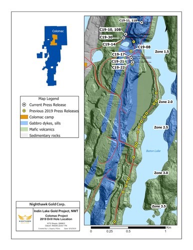
Figure 1. Plan View – Colomac Drillhole Locations (CNW Group/Nighthawk Gold Corp.)
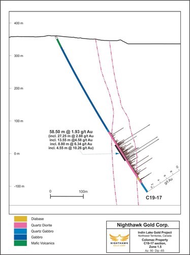
Figure 2. Cross Section – Colomac Zone 1.5 – Drillhole C19-17 (CNW Group/Nighthawk Gold Corp.)
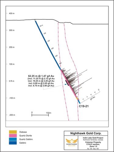
Figure 3. Cross Section – Colomac Zone 1.5 – Drillhole C19-21 (CNW Group/Nighthawk Gold Corp.)
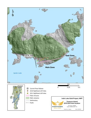
Figure 4. Plan View – Treasure Island Drillhole Locations (CNW Group/Nighthawk Gold Corp.)
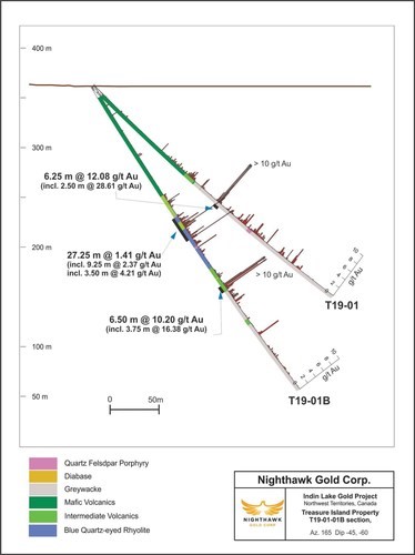
Figure 5. Cross Section – Treasure Island Drillholes – T19-01, and T19-01B (CNW Group/Nighthawk Gold Corp.)
First Phosphate Corp. (CSE: PHOS) (OTC: FRSPF) (FSE: KD0) is plea... READ MORE
MAG Silver Corp. (TSX:MAG) (NYSE American: MAG) announces the Com... READ MORE
Troilus Gold Corp. (TSX: TLG) (OTCQX: CHXMF) reports results from... READ MORE
Alamos Gold Inc. (TSX:AGI) (NYSE:AGI) reported new results from i... READ MORE
Titan Mining Corporation (TSX: TI) announces the results for the... READ MORE


