


IsoEnergy Ltd. (TSXV: ISO) (OTCQX: ISENF) is pleased to provide an update on the ongoing drilling program on the Hurricane zone at the Larocque East property. Highlights include assay results from drill hole LE19-16A and the intersection of uranium mineralization in drill hole LE19-18C1. The Hurricane zone is located on the Company’s 100% owned Larocque East property in the Eastern Athabasca Basin of Saskatchewan (Figure 1).
Highlights
Steve Blower, Vice President of Exploration commented: “Hurricane continues to deliver exceptional results, including the best mineralized interval to date in drill hole LE19-16A. I’m also encouraged that the key Hurricane structures were identified in undercutting drill hole LE19-19, a 250m step-out east of the Hurricane zone. This bodes well for the next drill holes on this section.”
Craig Parry, CEO commented: “The team has done a tremendous job of further testing and extending the Hurricane Deposit. The system is showing it has high-grade potential and now strike extent and scale. I’m particularly excited to see the results from our eastern most pathfinder hole LE19-19 and we look forward to reporting further results from the program where we have a further eight drill holes planned.”
Drill Hole LE19-16A Assays (Section 4635E)
Drill hole LE19-16A intersected the Hurricane zone 13.5m south of winter drill hole LE19-13. An interval of strong sandstone hosted uranium mineralization was intersected at 315.5-322.5m, just above the unconformity. The entire 7.0m interval averages 5.4% U3O8, 0.7% Ni and 0.1% Co and includes a 2.0m subinterval that averages 15.9% U3O8, 1.4% Ni and 0.1% Co. The highest-grade assay in the interval was 36.5% U3O8, 2.3% Ni and 0.1% Co over 0.5m. Table 1 compares the assay results in LE19-16A against previous intersections at the Hurricane zone. The location of the drill hole is shown in plan-view in Figure 2 and on a cross-section in Figure 3. Figure 4 is an annotated core photo of the mineralization.
Drill Hole LE19-18C1 Mineralization (Section 4735E)
Drill hole LE19-18C1 is a wedge off-cut from mineralized parent drill hole LE19-18. It was designed to evaluate the potential for additional mineralization north of LE19-18. The result was successful, with LE19-18C1 intersecting 5.0m of uranium mineralization >1,000 CPS, including 0.5m >10,000 CPS. The location is shown in plan-view on Figure 2 and on a cross-section in Figure 5. Assays are pending.
Drill Hole LE19-18 Assays (Section 4735E)
Drill hole LE19-18 (Figures 2 and 5) was completed as an along-strike step-out 100m to the east of drill hole LE19-16A. Chemical assays have now been received from this drill hole and it intersected 3.0m averaging 1.5% U3O8. The mineralization straddles the unconformity and includes 6.0% U3O8 over 0.5m.
Drill Hole LE19-19 (Section 4985E)
Completed as an under-cutting, along-strike step-out 250m east of drill holes LE19-18 and LE19-18C1, drill hole LE19-19 (Figures 2 and 6) was designed to locate the favourable structures and graphitic rock types associated with the Hurricane zone mineralization. This cross-section includes historical weakly mineralized drill hole KER-07. The results in drill hole LE19-19 are encouraging. The key package of faults in graphitic basement rocks is present in the drill core, and the intersection of those faults with the unconformity is currently being targeted. This drilling is located 500m east of the westernmost Hurricane zone drill hole, LE19-12.
Drill Hole LE19-20 (Section 4735E)
Drill hole LE19-20 (Figures 2 and 5) was completed on section with, and 12.5m north of, drill hole LE19-18C1. While it intersected considerable sandstone and basement alteration, no significantly elevated radioactivity was observed. This drill hole is interpreted to have intersected the unconformity north of the Hurricane zone. Significant potential still exists on this section to the south of LE19-18 – along strike of the strong mineralization intersected by drill hole LE19-16A. This area will be evaluated with drilling during this program.
Next Steps
Eight drill holes remain in the fully funded summer drilling program, as originally planned. The next drill holes will comprise additional drill holes on the LE19-18 and LE19-19 sections, further step-outs to the east, and infill drill holes on other sections where necessary.
The Larocque East Property
The 100% owned Property consists of 20 mineral claims totaling 8,371ha and is not encumbered by any royalties or other interests. Larocque East is immediately adjacent to the north end of IsoEnergy’s Geiger property and is 35 kilometres northwest of Orano Canada’s McClean Lake uranium mine and mill.
Along with other target areas, the Property covers a 15-kilometre-long northeast extension of the Larocque Lake conductor system; a trend of graphitic metasedimentary basement rocks that is associated with significant uranium mineralization at the Hurricane zone, and in several occurrences on Cameco Corp.’s neighbouring property to the southwest of Larocque East. The Hurricane zone was discovered in July, 2018 and was recently followed up with a 12-hole drilling campaign in the winter of 2019. Eleven of those 12 drill holes intersected substantial uranium mineralization, including 10.4% U3O8 over 3.5m in drill hole LE19-02 and 3.2% U3O8 over 8.5m in drill hole LE19-12. Drilling at Cameco Corp.’s Larocque Lake zone on the neighbouring property to the southwest has returned historical intersections of up to 29.9% U3O8 over 7.0 metres in drill hole Q22-040. Like the nearby Geiger property, Larocque East is located adjacent to the Wollaston-Mudjatik transition zone – a major crustal suture related to most of the major uranium deposits in the eastern Athabasca Basin. Importantly, the sandstone cover on the Property is thin, ranging between 140 metres and 330 metres in previous drilling. In addition to the Hurricane zone discovery, four historical drill holes have intersected weak uranium mineralization at other locations on the Property to date.
Table 1 – 2019 Hurricane Zone Intersections
| Hole-ID | From (m) | To (m) | Length (m) | Radioactivity1,2 (CPS) | Chemical Assays | Location | ||||
| U3O8 (%) | Ni (%) | Co (%) | ||||||||
| LE19-023 | 316.5 | 320.0 | 3.5 | >1,000 | 0.2 | 0.1 | 0.2 | Section 4560E | ||
| and | 326.5 | 330.0 | 3.5 | >1,000 | 10.4 | 0.8 | 0.0 | |||
| incl. | 328.5 | 330.0 | 1.5 | >20,000 | 23.6 | 1.6 | 0.0 | |||
| incl. | 329.0 | 329.5 | 0.5 | >50,000 | 38.2 | 1.5 | 0.1 | |||
| LE19-033 | 324.0 | 324.5 | 0.5 | >1,000 | 0.2 | 0.1 | 0.0 | Section 4560E | ||
| and | 326.5 | 329.5 | 3.0 | >1,000 | 2.7 | 2.3 | 0.0 | |||
| incl. | 328.5 | 329.5 | 1.0 | >5,000 | 7.6 | 6.6 | 0.1 | |||
| incl. | 329.0 | 329.5 | 0.5 | >20,000 | 13.3 | 11.8 | 0.1 | |||
| LE19-043 | 329.0 | 329.5 | 0.5 | >1,000 | 0.1 | 0.0 | 0.0 | Section 4560E | ||
| and | 333.0 | 333.5 | 0.5 | >1,000 | 0.4 | 0.2 | 0.0 | |||
| LE19-053 | No significantly elevated radioactivity | Section 4560E | ||||||||
| LE19-063 | 328.0 | 330.0 | 2.0 | >1,000 | 0.4 | 0.1 | 0.1 | Section 4585E | ||
| and | 332.0 | 336.0 | 4.0 | >5,000 | 3.8 | 1.1 | 0.0 | |||
| incl. | 333.5 | 335.5 | 2.0 | >10,000 | 5.5 | 0.7 | 0.0 | |||
| incl. | 333.5 | 334.0 | 0.5 | >20,000 | 13.7 | 1.2 | 0.0 | |||
| LE19-073 | 325.0 | 331.0 | 6.0 | >1,000 | 0.4 | 0.8 | 1.4 | Section 4585E | ||
| incl. | 328.0 | 328.5 | 0.5 | >5,000 | 1.0 | 4.9 | 9.3 | |||
| LE19-083 | 326.5 | 327.0 | 0.5 | >1,000 | 0.4 | 0.1 | 0.1 | Section 4535E | ||
| and | 333.0 | 336.5 | 3.5 | >1,000 | 0.8 | 1.5 | 0.4 | |||
| incl. | 335.5 | 336.0 | 0.5 | >10,000 | 3.7 | 8.3 | 1.3 | |||
| LE19-093 | 325.0 | 329.5 | 4.5 | >1,000 | 4.2 | 1.1 | 0.8 | Section 4535E | ||
| incl. | 327.0 | 329.0 | 2.0 | >20,000 | 6.8 | 1.9 | 1.3 | |||
| LE19-103 | 331.5 | 333.0 | 1.5 | >1,000 | 0.6 | 1.7 | 1.9 | Section 4535E | ||
| LE19-113 | 333.0 | 333.5 | 0.5 | >5,000 | 2.1 | 0.1 | 0.1 | Section 4485E | ||
| LE19-123 | 320.5 | 329.0 | 8.5 | >1,000 | 3.2 | 2.1 | 0.2 | Section 4485E | ||
| incl. | 324.5 | 327.0 | 2.5 | >10,000 | 7.2 | 0.6 | 0.0 | |||
| incl. | 324.5 | 325.0 | 0.5 | >20,000 | 3.5 | 0.3 | 0.0 | |||
| incl. | 326.0 | 327.0 | 1.0 | >20,000 | 14.3 | 1.1 | 0.0 | |||
| incl. | 328.5 | 329.0 | 0.5 | >20,000 | 12.8 | 15.0 | 0.4 | |||
| LE19-133 | 320.0 | 320.5 | 0.5 | >1,000 | 0.2 | 0.0 | 0.0 | Section 4635E | ||
| and | 321.5 | 324.0 | 2.5 | >1,000 | 0.6 | 0.2 | 0.5 | |||
| incl. | 322.5 | 323.0 | 0.5 | >10,000 | 1.6 | 0.4 | 1.1 | |||
| LE19-14B4 | 323.0 | 325.0 | 2.0 | >1,000 | 0.2 | 0.0 | 0.1 | Section 4535E | ||
| and | 327.5 | 331.0 | 3.5 | >1,000 | 0.3 | 0.3 | 0.7 | |||
| incl. | 327.5 | 328.0 | 0.5 | >5,000 | 0.6 | 0.1 | 0.4 | |||
| incl. | 329.0 | 329.5 | 0.5 | >5,000 | 0.7 | 0.3 | 0.7 | |||
| LE19-154 | No significantly elevated radioactivity | Section 4735E | ||||||||
| LE19-16A4 | 315.5 | 322.5 | 7.0 | >1,000 | 5.4 | 0.7 | 0.1 | Section 4635E | ||
| incl. | 318.0 | 320.0 | 2.0 | >10,000 | 15.9 | 1.4 | 0.1 | |||
| and incl. | 320.5 | 321.0 | 0.5 | >10,000 | 3.2 | 2.1 | 0.0 | |||
| LE19-174 | No significantly elevated radioactivity | Section 4635E | ||||||||
| LE19-184 | 323.0 | 326.0 | 3.0 | >1,000 | 1.5 | 0.1 | 0.1 | Section 4735E | ||
| incl. | 325.0 | 325.5 | 0.5 | >10,000 | 6.0 | 0.1 | 0.1 | |||
| LE19-18C15 | 261.0 | 266.0 | 5.0 | >1,000 | Pending | Section 4735E | ||||
| incl. | 261.5 | 262.0 | 0.5 | >10,000 | ||||||
| LE19-19 | No significantly elevated radioactivity | Section 4985E | ||||||||
| LE19-20 | No significantly elevated radioactivity | Section 4735E | ||||||||
| Notes: | 1. Radioactivity is total gamma from drill core measured with an RS-125 hand-held spectrometer. | |||||||||
| 2. Measurements of total gamma cps on drill core are an indication of uranium content, but may not correlate with uranium chemical assays. | ||||||||||
| 3. Winter 2019 drilling program – previously disclosed | ||||||||||
| 4. Summer 2019 drilling program – radioactivity previously disclosed
5. Collared 59m down-hole in LE19-18 |
||||||||||
Qualified Person Statement
The scientific and technical information contained in this news release was prepared by Andy Carmichael, P.Geo., IsoEnergy’s Senior Geologist, who is a “Qualified Person” (as defined in NI 43-101 – Standards of Disclosure for Mineral Projects). Mr. Carmichael has verified the data disclosed. As drill holes LE19-16A and LE19-18 are oriented very steeply (-80 degrees) into a zone of mineralization that is interpreted to be horizontal, the true thickness of the intersections is expected to be greater than or equal to 90% of the core lengths. This news release refers to properties other than those in which the Company has an interest. Mineralization on those other properties is not necessarily indicative of mineralization on the Company’s properties. For additional information regarding the Company’s Larocque East Project, including its quality assurance and quality control procedures, please see the Technical Report dated effective May 15, 2019 on the Company’s profile at www.sedar.com.
About IsoEnergy
IsoEnergy is a well-funded uranium exploration and development company with a portfolio of prospective projects in the eastern Athabasca Basin in Saskatchewan, Canada and a historic inferred mineral resource estimate at the Mountain Lake uranium deposit in Nunavut. IsoEnergy is led by a Board and Management team with a track record of success in uranium exploration, development and operations. The Company was founded and is supported by the team at its major shareholder, NexGen Energy Ltd.
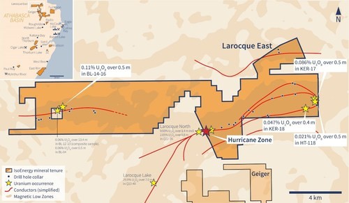
Figure 1 –Larocque East Property Map (CNW Group/IsoEnergy Ltd.)
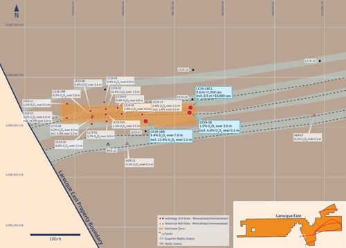
Figure 2 – Drill Hole Location Map (CNW Group/IsoEnergy Ltd.)
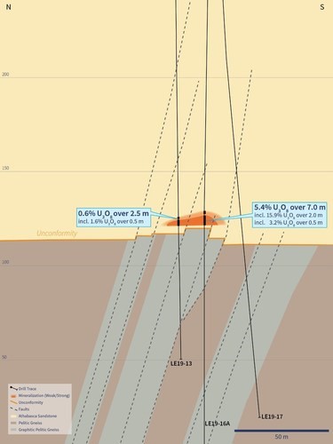
Figure 3 – Cross Section 4635E (CNW Group/IsoEnergy Ltd.)
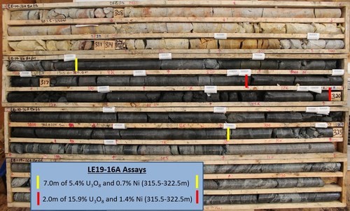
Figure 4 –LE19-16A Core Photo Annotated with Assay Results (CNW Group/IsoEnergy Ltd.)
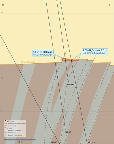
Figure 5 – Cross Section 4735E (CNW Group/IsoEnergy Ltd.)
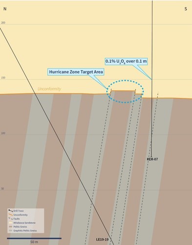
Figure 6 – Cross Section 4985E (CNW Group/IsoEnergy Ltd.)
First Phosphate Corp. (CSE: PHOS) (OTC: FRSPF) (FSE: KD0) is plea... READ MORE
MAG Silver Corp. (TSX:MAG) (NYSE American: MAG) announces the Com... READ MORE
Troilus Gold Corp. (TSX: TLG) (OTCQX: CHXMF) reports results from... READ MORE
Alamos Gold Inc. (TSX:AGI) (NYSE:AGI) reported new results from i... READ MORE
Titan Mining Corporation (TSX: TI) announces the results for the... READ MORE


