







Stallion Uranium Corp. (TSX-V: STUD) (OTCQB: STLNF) (FSE: B76) is pleased to announce the successful completion of an expanded ground gravity survey at its flagship Coyote target. The survey has delineated multiple new high-priority uranium drill targets while significantly extending the prospective strike length of the Coyote exploration corridor within the Moonlite Project, part of the southwestern Athabasca Basin Joint Venture with Atha Energy Corp. (TSX-V: SASK).
Matthew Schwab, CEO of Stallion, said, “Through every step of this exploration program we continue to strengthen our confidence in the Coyote corridor. The expanded gravity survey has materially increased the number of high-priority drill targets while further validating the geological model we have been building over the past several years. As we continue integrating each dataset, we’re seeing a larger and more compelling exploration system emerge.”
“The integration of multiple independent geophysical datasets continues to refine drill targeting while systematically reducing geological risk across the Coyote Corridor.”
Completed in two phases, the expanded gravity survey significantly increased coverage across the interpreted Coyote conductive corridor. The expanded survey builds upon the Company’s previously announced gravity results dated July 14, 2025 and provides substantially greater coverage across the interpreted conductive corridor.
The new data further enhances Stallion’s understanding of the structural architecture controlling uranium mineralization and has identified several additional gravity low anomalies spatially associated with conductive trends interpreted from MobileMT and ground TDEM surveys.
Highlights:
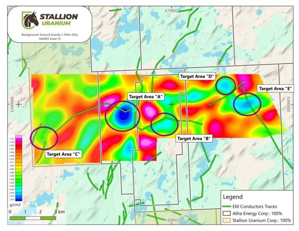
Figure 1: Updated ground gravity inversion (-150 m ASL) over the Coyote target showing completed survey extension with interpreted EM conductors
Gravity Survey Extension:
The expanded gravity program was designed to extend coverage beyond the original western survey area following encouraging results announced earlier this year, which identified a prominent gravity low coincident with interpreted basement structures and conductive trends.
The eastern extension has successfully expanded the survey footprint across the remainder of the interpreted conductive corridor, resulting in the identification of several additional discrete gravity low features (Figure 1). The gravity lows occur within areas interpreted to contain significant structural complexity and are spatially associated with electromagnetic conductors interpreted from previous MobileMT, HeliSam and ground TDEM surveys.
The integrated dataset now outlines multiple priority target areas distributed along the Coyote corridor outside of the previous survey area, providing several compelling targets for future drill testing. Collectively, these targets represent some of the highest-priority drill opportunities identified on the Coyote Corridor to date.
In the Athabasca Basin, gravity lows are commonly associated with hydrothermal alteration and structural disruption. When these features coincide with graphitic conductors and fault intersections, they become highly attractive uranium drill targets.
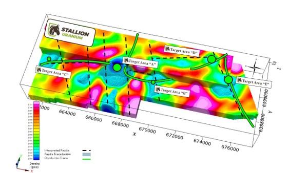
Figure 2: Three-dimensional view of the integrated Coyote exploration model showing the gravity inversion, interpreted basement faults, and EM conductor traces
Five priority target areas (A through E) have been identified where gravity lows coincide with interpreted structures and conductive corridors
Integrated Geological Model
Following completion of the gravity survey extension, Stallion integrated the new gravity data with previously completed MobileMT, ground TDEM, magnetic, and structural interpretations to generate an updated three-dimensional exploration model (Figure 2).
The gravity inversion suggests several gravity low features extend beneath the unconformity and are associated with interpreted fault intersections and graphitic conductive horizons. These relationships are consistent with the structural setting observed at numerous significant Athabasca Basin uranium deposits, where hydrothermal alteration commonly produces localized density reductions adjacent to reactivated basement structures.
The updated geological model will be used to refine future drill collar locations and prioritize exploration across the broader Coyote corridor.
Gravity Data Inversion:
Convolutions Geoscience inverted the ground gravity data, utilizing industry-standard 3D inversion techniques to estimate subsurface density variations from the processed gravity data. The objective was to assist in delineating alteration zones of interest for uranium exploration.
Convolutions Geoscience carried out a 3D inversion of the gravity data to create a voxel product of subsurface density anomalies using the industry-standard Fullagar Vertical Prism Magnetic and Gravity (VPmg) codes. The inputs into the inversion were the free air anomaly from the dataset; lake bathymetry data for water depth; digital terrain model (DTM) for the project area, in addition to NASA Shuttle Radar Topography Mission (SRTM) data for surrounding areas; and density constraints for sandstone cover rocks above the unconformity as well as basement rocks below the unconformity. Convolutions created a VPmg gravity inversion using 40m x 40m surface XY blocks and Z blocks of 10m at the surface, increasing by 5% at depth. The total model block depth exceeds 10km.
Next Steps:
The newly identified gravity targets will be incorporated into Stallion’s upcoming drill planning, with priority given to areas where gravity lows coincide with conductive corridors and interpreted basement structures. The Company believes these integrated targets represent some of the highest-priority exploration opportunities identified to date on the Coyote Corridor and will form the foundation of future drill campaigns.
Qualifying Statement:
The foregoing scientific and technical disclosures for Stallion Uranium have been reviewed and approved by Darren Slugoski, P.Geo., VP Exploration, a registered member of the Professional Engineers and Geoscientists of Saskatchewan. Mr. Slugoski is a Qualified Person as defined by National Instrument 43-101.
About Stallion Uranium Corp.:
Stallion Uranium is working to ‘Fuel the Future with Uranium’ through the exploration of roughly 1,700 sq/km in the Athabasca Basin, home to the largest high-grade uranium deposits in the world. The company, with JV partner Atha Energy holds the largest contiguous project in the Western Athabasca Basin adjacent to multiple high-grade discovery zones. With a commitment to responsible exploration and cutting-edge technology such as the use of the proprietary Haystack TI technology, Stallion is positioned to play a key role in the future of clean energy.
Our leadership and advisory teams are comprised of uranium and precious metals exploration experts with the capital markets experience and the technical talent for acquiring and exploring early-stage properties.
Brutus Mining Inc. (CSE: BRU) (FSE: ZI3) is pleased to announce that it has closed its non-brokered ... READ MORE
Jaguar Uranium Corp. (NYSE American: JAGU) is pleased to announce an independent Mineral Resource E... READ MORE
Auro Metals Inc. (TSX-V: AURO) (OTCQB: AURFF), is pleased to announce the assay results of the fina... READ MORE
Endeavour Silver Corp. (NYSE: EXK) (TSX: EDR) is pleased to announce that repairs to the primary bal... READ MORE
Scorpio Gold Corp. (NASDAQ: SGLD) (TSX-V: SGLD) (OTCQB: SRCRF) (FSE: RY9) is pleased to announce re... READ MORE


