


Highlights
Scorpio Gold Corp. (TSX-V: SGN) (OTCQB: SRCRF) (FSE: RY9) is pleased to announce results from three step-out holes of the Phase Two drill program at the Manhattan District Project, Nevada, USA: 26MN-082, 26MN-084 and 26MN-086, see Figure 1. The results are tabulated in Table 1 and discussed below. Scorpio Gold has drilled 92 drill holes to date from its Phase Two diamond drilling program, 25MN-011 through 25MN-045, 26MN-046 through 26MN-101, and 26MN-103, for a grand total of 25,919 m. With the results herein, Scorpio Gold has reported assays on 76 of these (25MN-011 through 25MN-045, 26MN-046 through 26MN-080, and 26MN-082 through 26MN-086, and 26MN-088), totalling 22,362 m, and assays are pending from 16 holes (26MN-081 and 26MN-087, and 26MN-089 through 26MN-101, and 26MN-103), totalling 3,557 m. The pending results will be reported as they become available. In addition to the Phase Two drill program, the Company has begun reviewing historic core that is available at Manhattan. Any new significant results will be included as they become available.
“With each hole we drill, our confidence builds that the volcanic units at the north end of Manhattan host the potential for much larger-scale mineralization than the narrow structures historic operators focused on — the very target we have been systematically testing along the Caldera Margin. Hole 26MN-086 is a good example, returning 45.23 metres of 1.27 g/t gold built around a high-grade feeder of 8.06 g/t over 2.80 metres that appears to bleed outward into the surrounding tuffs. This is a broad, volcanic-hosted signature reminiscent of the nearby Round Mountain system, and ours is the first program to drill these rocks specifically expecting to find it.
What is most encouraging is how repeatable this is becoming — hole after hole along the margin is returning mineralization from these tuffs. That consistency is giving us growing conviction that the volcanic-hosted mineralization need not be confined to the Caldera Margin, but could continue inward into the broader Manhattan Caldera itself. It remains early, but if the volcanics behave as we are seeing, the Manhattan Caldera could open up as a meaningful, larger-scale opportunity well beyond the margin we have tested to date. That potential, alongside our steady progress at Zanzibar, is why we see real room for the resource to grow from here,” said Harrison Pokrandt, VP Exploration for Scorpio Gold.
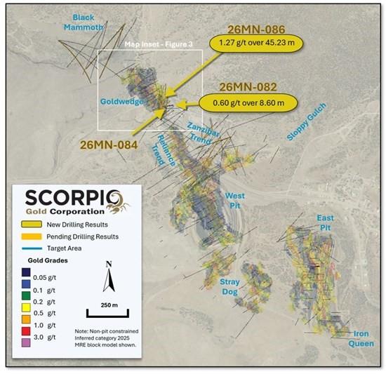
Figure 1. Surface Plan Map of drill results, with highlights noted. Map Inset area shown in Figure 3.
Drill hole 26MN-086 is a 50 m step-out, at Goldwedge, to the north of hole 26MN-048 (0.62 g/t over 32.13 m), see news release dated February 27, 2026, and 24MN-009 (1.69 g/t over 55.70 m), see news release dated December 11, 2024. Drill holes 26MN-084 and 26MN-082 are also 50 m step-outs, at Goldwedge, to the northeast of hole 26MN-048. Both drill holes tested inside and beyond the Inferred Resource Constraining Pit (“IRCP”), targeting new mineralization outside of the 2025 MRE block model, see Figures 3, 6, and 7. For further details see “Mineral Resource Estimate and NI 43-101 Technical Report, Manhattan Property, Nye County, Nevada” with an effective date of June 4, 2025, on Scorpio Gold’s website at https://wp-scorpiogold-2025.s3.ca-central-1.amazonaws.com/media/2025/10/SGN_Manhattan_Mineral_Resource_Estimate_-_Amended_43-101.pdf.
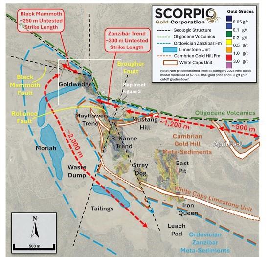
Figure 2. Geology Surface Plan Map of Target Areas, with untested strike lengths through the Ordovician Zanzibar Formation associated mineralization noted. Map Inset area shown in Figure 3.
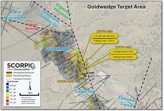
Figure 3. Inset Surface Plan Map of Goldwedge Target Area, with drill hole traces projected to surface and result highlights noted.
| Drill Hole ID | Target | From (m) | To (m) | Intercept¹ (m) | Gold (g/t) |
| Azimuth / Dip | |||||
| 26MN-082 | Goldwedge | 9.75 | 15.85 | 6.10 | 0.54 |
| 89 m | 082° / -45° | 21.95 | 37.19 | 15.24 | 0.14 |
| 40.78 | 49.38 | 8.60 | 0.6 | ||
| 26MN-084 | Goldwedge | No significant intervals. Encountered stope at ~49 m. | |||
| 78 m | 115° / -58° | ||||
| 26MN-086 | Goldwedge | 12.95 | 19.05 | 6.10 | 0.16 |
| 233 m | 350° / -65° | 104.85 | 110.43 | 5.58 | 0.31 |
| 115.83 | 122.99 | 7.16 | 0.68 | ||
| 137.95 | 183.18 | 45.23 | 1.27 | ||
| including | 160.26 | 167.73 | 7.47 | 2.4 | |
| including | 172.31 | 175.11 | 2.80 | 8.06 | |
| ¹ Intervals contain no more than 3 continuous metres grading less than 0.1 g/t gold. | |||||
Table 1. Results from the current batch of drill holes. Note: There is insufficient geological information to estimate a true width for the drill intercepts reported.
Goldwedge Results:
26MN-082: This drill hole tested mineralization in the Goldwedge area and along the Caldera margin. The drill hole contains three intervals hosted in Ordovician Zanzibar Formation limestone units, including 0.54 g/t gold over 6.1 m from 9.75 m, 0.14 g/t gold over 15.24 m from 21.95 m and 0.60 g/t gold over 8.6 m from 40.78 m. The later interval sits directly above the contact with Oligocene Round Rock Formation volcanic units at 49.38 m.
26MN-084: This drill hole tested mineralization in the Goldwedge area and along the Caldera margin. The drill hole encountered a void from 49.23 m to 78.00 m, where the hole was terminated. This void is not mapped on previous underground workings but is interpreted as a likely stope in the Goldwedge Underground mine. This hole contains no significant intervals, but all mineralization is hosted within Ordovician Zanzibar Formation limestone units.
26MN-086: This drill hole tested mineralization in the Goldwedge area and along the Caldera margin. The drill hole contains one interval hosted in Ordovician Zanzibar Formation limestone units of 0.16 g/t gold over 6.1 m from 12.95 m. The drill hole contains two intervals hosted in Cambrian Gold Hill Formation fine grained clastic meta-sediments and carbonate units. The first interval sits directly below the contact with Ordovician Zanzibar Formation, and is noted as 0.31 g/t gold over 5.58 m from 104.85 m. The second interval is 0.68 g/t gold over 7.16 m from 115.83 m. The final interval is hosted within Cambrian Gold Hill Formation meta-sediments and Oligocene Round Rock Formation volcanic units and is 1.27 g/t gold over 45.23 m from 137.95 m (see Figure 4). The Cambrian to Oligocene contact sits at 177.70 m. This interval includes intervals of 2.40 g/t gold over 7.47 m from 160.26 m and 8.06 g/t gold over 2.8 m from 172.31 m (see Figure 5), both hosted in the Cambrian Gold Hill Formation.
These Goldwedge intervals represent new mineralization inside and outside the current IRCP, see cross-section A to A’ (Figure 6) and cross-section B to B’ (Figure 7).
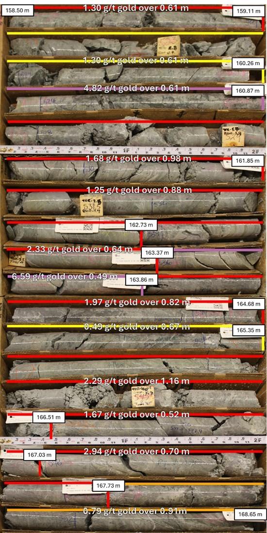
Figure 4. Drill hole 26MN-086, interval 158.50 m to 165.65 m, displaying fine grained meta-sediments of the Cambrian Gold Hill Formation with quartz-calcite-adularia epithermal veins.
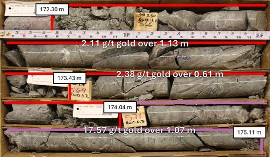
Figure 5. Drill hole 26MN-086, interval 172.30 m to 175.11 m, displaying fine grained meta-sediments of the Cambrian Gold Hill Formation with quartz-calcite-adularia epithermal veins.
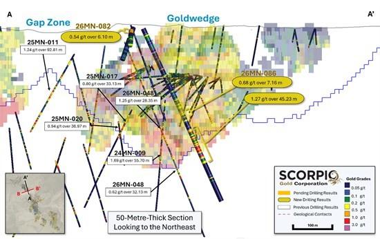
Figure 6. Cross-section A-A’, showing gold grades with reported intervals highlighted.
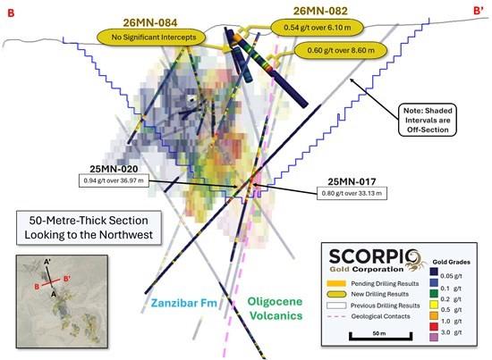
Figure 7. Cross-section B-B”, showing gold grades with reported intervals highlighted.
QA/QC
HQ sized diamond drill core samples were cut in halves, then bagged and secured with security tags to ensure integrity during transportation to the Reno, NV, Paragon Geochemical facility for preparation. For quality assurance, unmarked coarse blanks, unmarked certified reference materials, and requested laboratory duplicates were inserted into the sampling sequence. QA samples were systematically inserted into each batch of samples, amounting to approximately 10% of the run of samples. Samples were analyzed for gold using method PA-AU02 (~500 g), a two-cycle PhotonAssayTM analysis of crushed material (70% passing 2 mm). All Paragon Geochemical facilities comply with ISO 17025:2017.
About the Manhattan District
Manhattan, located in the Walker Lane Trend of Nevada, USA, is road accessible and lies approximately 20 kilometers south of the operating Round Mountain Gold Mine (https://www.kinross.com/operations/default.aspx#americas-roundmountain), which has produced more than 15 million ounces of gold. For the first time, the Company has consolidated Manhattan’s past-producing mines under a single entity that holds valuable permitting and water rights. Historically, Manhattan has produced approximately 700,000 ounces of gold from high-grade placer and lode operations dating from the late 1890s through to the mid-2000s.¹ The maiden mineral resource estimate covering the Goldwedge and Manhattan Pit areas of Manhattan is comprised of 18,343,000 tonnes grading 1.26 g/t gold for a total of 740,000 oz contained gold in the inferred category.²
A historical mineral resource estimate covers the Black Mammoth, April Fool, Hooligan, Keystone, and Jumbo areas of Manhattan and comprises 1,652,325 tonnes grading 5.89 g/t gold for a total of 303,949 oz contained gold.³ The deposit is interpreted as a low-sulfidation, epithermal, gold-rich system situated adjacent to the Tertiary-aged Manhattan caldera in the Southern Toquima Range of Nevada. A “Qualified Person” as defined in National Instrument 43-101 – Standards of Disclosure for Mineral Projects has not done sufficient work to make the Historical MRE current, and the Company is not treating the Historical MRE as current.
Notes
The Company considers the Historical MRE relevant as it demonstrates the presence of significant gold mineralization across multiple zones within Manhattan; however, its reliability is uncertain because it was prepared prior to the adoption of the current CIM Definition Standards and current QA/QC practices. The Historical MRE provides limited disclosure of assumptions, parameters, estimation methods, cutoff grades, and QA/QC protocols, and therefore these cannot be fully verified by the Company. The categories used in the historical estimate predate, and are not directly comparable to, current CIM Definition Standards, and the Company is not treating the Historical MRE as a current Mineral Resource Estimate. To upgrade and verify the Historical MRE in order to make it a current Mineral Resource Estimate, the Company would be required to undertake confirmatory drilling, modern QA/QC sampling, validation and digitization of historical datasets and updated geological modeling followed by the preparation of a new Mineral Resource Estimate in accordance with CIM Definition Standards and NI 43-101. The Company encourages readers to exercise appropriate caution when evaluating the Historical MRE.
All scientific and technical information relating to Manhattan pertaining to the Historical MRE contained in this news release is derived from the Technical Report dated May 1997 titled “Exploration and Pre-Production Mine Development, Manhattan District Project, Nye County” prepared by New Concept Mining, Inc. The information contained herein in respect of the Historical MRE is subject to all the assumptions, qualifications and procedures set out in the Historical Technical Report and reference should be made to the full text of the Historical Technical Report.
Qualified Person
The scientific and technical information in this news release has been reviewed, verified and approved by Thomas Poitras, P. Geo., Chief Geologist of Scorpio Gold, a “Qualified Person”, as defined under National Instrument 43-101 Standards of Disclosure for Mineral Projects. Verification included review of laboratory certificates, review of field logs and chain-of-custody records, inspection of blank/standard/duplicate performance, and review of collar and down-hole survey data. No limitations or failures to verify were identified.
About Scorpio Gold Corp.
Scorpio Gold holds a 100% interest in the Manhattan District located in the Walker Lane Trend of Nevada, USA. Scorpio Gold’s Manhattan District is ~4,780-hectares and comprises the advanced exploration-stage Goldwedge Mine, with a 400 ton per day maximum capacity gravity mill, and four past-producing pits that were acquired from Kinross in 2021 (see news release dated March 25, 2021 https://scorpiogold.com/news/scorpio-gold-closes-purchase-of-kinross-manhattan-property-nye-county-nevada/). The consolidated Manhattan District presents an exciting late-stage exploration opportunity, with over 140,000 metres of historical drilling, significant resource potential, and valuable permitting and water rights.
Imperial Metals Corporation (TSX:III) reports copper and gold p... READ MORE
Aldebaran Resources Inc. (TSX-V: ALDE) (OTCQX: ADBRF) and its maj... READ MORE
Nevada Sunrise Metals Corporation (TSX-V: NEV) (OTC Pink: NVSGF)... READ MORE
Newmont Corporation (NYSE: NEM) (ASX: NEM) (PNGX: NEM) announced ... READ MORE
Scorpio Gold Corporation (TSX-V: SGN) (OTCQB: SRCRF) (FSE: RY9) i... READ MORE


