


Onyx Gold Corp. (TSX-V: ONYX) (OTCQX: ONXGF) is pleased to the announce the discovery of a new zone of near-surface gold mineralization, 250 meters southwest of the Argus North Zone. This new discovery the latest advancement of the Company’s ongoing 75,000 m phase I/II/III diamond drill program at its 100%-owned Munro-Croesus Project, located 75 km east of Timmins, Ontario.
Results reported today from Argus West include two step-out drill holes, MC25-213 and MC25-199, completed 250 m and 430 m respectively from Argus North along the newly prioritized Argus Fault. This northeast-southwest-trending, moderately to steeply northwest-dipping structure is emerging as an important control on gold mineralization. Two additional drill holes are also reported today, which tested targets up to 925 m southwest of Argus North.
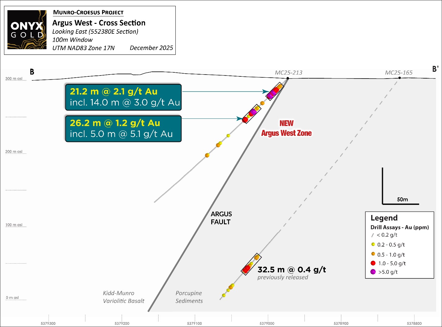
At Argus West, drill hole MC25-213 intersected multiple occurrences of visible gold (Plate 1) returning 21.2 m grading 2.1 grams per tonne gold starting at 9.8 m from surface within mafic variolitic volcanic rocks in the structural hanging wall to the Argus Fault. Drill hole MC25-199, a further 180 m to the southwest, intersected 14.0 m grading 1.0 g/t Au hosted by fine-grained metasedimentary rocks, in the structural footwall to the Argus Fault.
New Highlights from Argus West
“Argus West is a significant new discovery that continues to demonstrate the scale potential of the Argus gold system,” said Brock Colterjohn, President & CEO. “Intersecting near-surface gold mineralization 250 meters southwest of Argus North in both volcanic and sedimentary host rocks is a new and encouraging development for us, and highlights the fertility of the newly prioritized Argus Fault. Seeing the system develop across multiple lithologies supports our view that Argus is part of a larger, structurally controlled corridor with meaningful expansion potential. With three rigs active, we are continuing systematic step-outs along strike and down-dip to continue to evaluate the size of this new zone and the broader Argus trend.”
Discussion of 2025 Drill Results
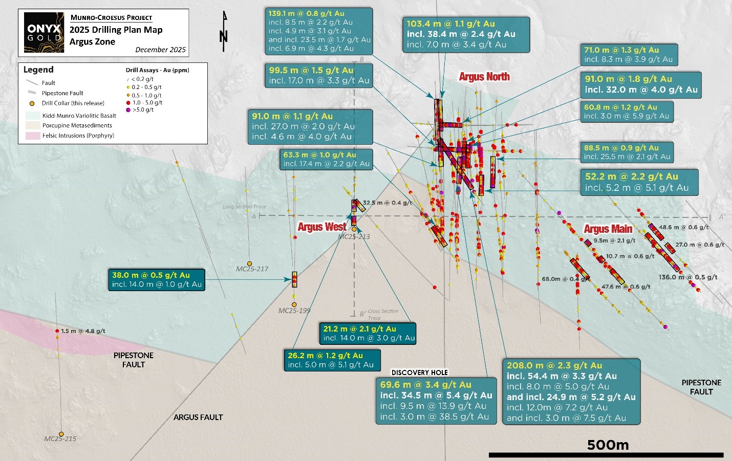
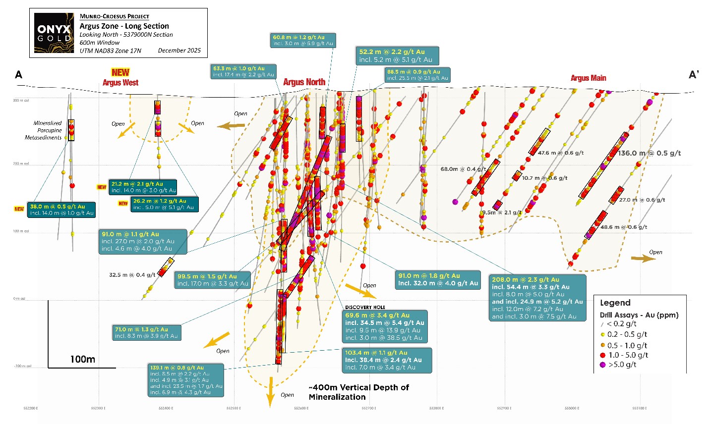
The Argus North Zone is located on the western half of the Munro-Croesus Project, approximately 150 meters north of the regional Pipestone Fault, a major structural corridor that hosts several significant gold deposits in the Timmins camp. The discovery hole at Argus North, MC24-163, was reported earlier this year, and returned 69.6 m grading 3.4 g/t Au, including 34.5 m grading 5.4 g/t Au and 9.5 m grading 13.9 g/t Au (see Company news release dated April 10, 2025).
Argus North lies roughly 100 meters north of the east-west trending Argus Main Zone, which represents a separate 750 m x 200 m near-surface bulk-tonnage gold target (e.g., 1.0 g/t Au over 63.3 m and 0.5 g/t Au over 136 m).
Gold mineralization at Argus North is distinguished by both broad zones (50 m to over 100 m) of +1 g/t Au mineralization containing multiple continuous higher-grade sub-intervals (e.g. 34.5 m grading 5.4 g/t in hole MC25-163, 24.9 m grading 5.2 g/t in MC25-232, and 5.2 m grading 5.1 g/t in hole MC25-180) (Figure 1). Geologically, the high-grade sub-intervals at Argus North are closely associated with zones of strong albitization and silicification, pyritic stringers, and localized porphyritic intrusions within variolitic basalt and volcanic breccias cut by dominant northeast-trending faults and associated fractures. This combination of alteration and structural preparation is interpreted to be a key control on gold deposition. Drilling to date has demonstrated excellent vertical continuity of mineralization, now traced from surface to approximately 400 meters depth, with the system remaining open along strike, down-dip and down-plunge.
Results reported today from the new Argus West Zone include two (2) step-out diamond drill holes, MC25-213 and MC25-199, which were completed 250 m and 430 m, respectively, from Argus North Zone along the Argus Fault, a key northeast-southwest-trending, moderately to steeply dipping structure that appears to play an important role in the locus of gold mineralization.
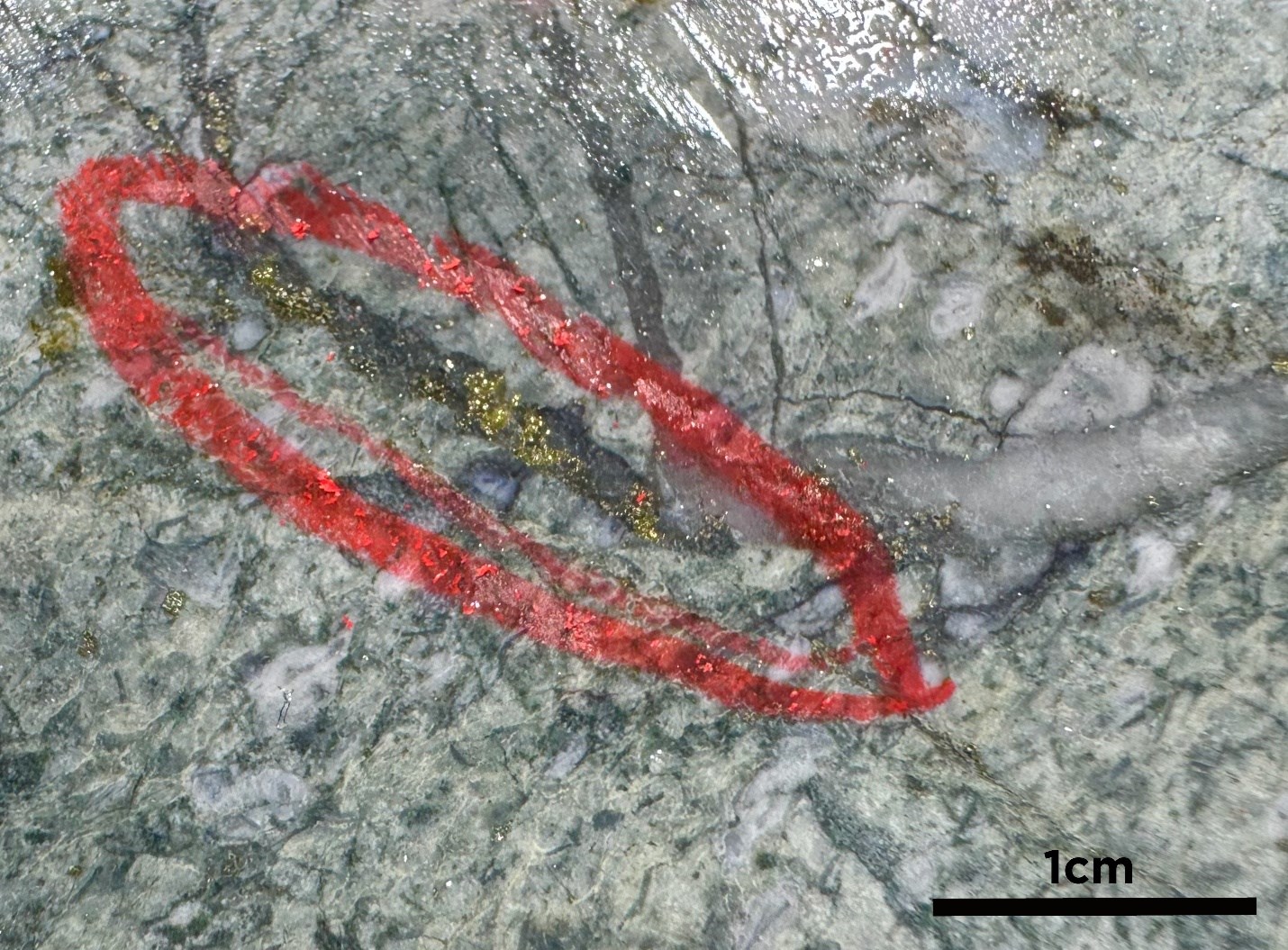
Drill hole MC25-213 returned 21.2 m grading 2.1 g/t Au starting at 9.8 m from surface within mafic variolitic volcanic rocks in the hanging wall to the Argus Fault. The variolitics are strongly albite-altered with a moderate crackle brecciation, and fine-grained disseminated to fracture-controlled pyrite, similar to Argus North. Multiple visible gold occurrences at approximately 27.0 m and 65.5 m depth downhole are associated with quartz ± carbonate veins that define the crackle breccia (Plate 1). Although interpreted to be broadly equivalent mineralizing systems, the limited observation of visible gold at Argus North indicates that Argus West may represent a distinct mineralization style with more efficient gold deposition focused in breccia units near the Argus Fault.
Drill hole MC25-199, a further 180 m to the southwest, intersected 14.0 m grading 1.0 g/t Au within fine-grained metasedimentary rocks, in the foot wall to the Argus Fault. Strong sericite alteration with an increase in quartz-carbonate veining characterizes the mineralized interval.
Drill hole MC25-215 was designed to test for gold mineralization associated with felsic intrusions adjacent to the Pipestone Fault, located 925 m southwest of Argus North. The hole returned 1.5 m grading 4.8 g/t Au in fine-grained metasedimentary rocks, confirming a new, fertile gold mineralizing environment. The metasedimentary rocks are intruded by multiple quartz-feldspar porphyritic intrusions, up to 50 m thick and are strongly sericite-altered with quartz-carbonate veining.
Drill hole MC25-217 was collared 100 m west of drill hole MC25-199, but north of the Argus Fault and returned no significant values.
The Company is aggressively following up on this discovery at Argus West with 50 m spaced step-out drill holes, immediately east, west and down-dip of drill hole MC25-213, with other holes planned to systematically test the Argus Fault along strike.
Details for drill hole assays reported in this news release are shown in Figures 1, 2, 3, 4 and Table 1.
Table 1 – Significant Assay Results from Recent Drilling Completed at the Argus North Zone
| Target | From | To | Length | Au |
| Drill Hole | (m) | (m) | (m) | (g/t) |
| Argus West | ||||
| MC25-199 | 21.5 | 28.5 | 7.0 | 0.2 |
| And | 55.5 | 93.5 | 38.0 | 0.5 |
| Including | 67.5 | 81.5 | 14.0 | 1.0 |
| Including | 78.5 | 81.5 | 3.0 | 2.4 |
| And | 195.9 | 197.4 | 1.5 | 3.0 |
| And | 302.5 | 308.0 | 5.5 | 0.2 |
| MC25-213 | 13.8 | 35.0 | 21.2 | 2.1 |
| Including | 21.0 | 35.0 | 14.0 | 3.0 |
| Including | 27.0 | 28.0 | 1.0 | 19.7 |
| And | 55.8 | 82.0 | 26.2 | 1.2 |
| Including | 64.8 | 69.8 | 5.0 | 5.1 |
| Including | 64.8 | 67.4 | 2.6 | 9.1 |
| Including | 64.8 | 66.3 | 1.5 | 13.7 |
| MC25-215 | 303.5 | 305.0 | 1.5 | 4.8 |
| MC25-217 | No Significant Assays | |||
*Intersections are reported as drilled width; true width is estimated to be 70-90% of drilled width.
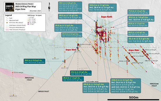
Figure 1 – Plan Map Highlighting Argus North/Argus West Zone Drill Holes Reported in this Release
To view an enhanced version of this graphic, please visit:
https://images.newsfilecorp.com/files/9800/276730_cb5c3229d420db7b_001full.jpg

Figure 2 – Longitudinal Section Highlighting Argus North/Argus West Zone Drill Holes Reported in this Release
To view an enhanced version of this graphic, please visit:
https://images.newsfilecorp.com/files/9800/276730_cb5c3229d420db7b_002full.jpg

Figure 3 – Cross Section Highlighting Argus West Zone Drill Hole MC25-213 Reported in this Release
To view an enhanced version of this graphic, please visit:
https://images.newsfilecorp.com/files/9800/276730_cb5c3229d420db7b_003full.jpg
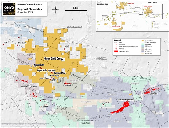
Figure 4 – Location of the Munro-Croesus Gold Project, Ontario
To view an enhanced version of this graphic, please visit:
https://images.newsfilecorp.com/files/9800/276730_cb5c3229d420db7b_004full.jpg

Plate 1 – Visible Gold from Drill Hole MC25-213 at 27 m Downhole Depth
To view an enhanced version of this graphic, please visit:
https://images.newsfilecorp.com/files/9800/276730_cb5c3229d420db7b_005full.jpg
The Munro-Croesus Project
The Munro-Croesus Project is located along Highway 101 in the heart of the Abitibi greenstone belt, Canada’s premier gold mining jurisdiction (Figure 2). This large, 100% owned land package includes the past-producing Croesus Gold Mine, which yielded some of the highest-grade gold ever mined in Ontario. Extensive land consolidation from 2020-2025 has unified the patchwork of patented and unpatented mining claims surrounding the Croesus Gold Mine into one coherent package and enhanced the project’s exploration potential.
The Project covers 109 km2 of highly prospective geology within the influence of major gold-bearing structural breaks. Bulk-tonnage gold deposits located in the immediate region include the Fenn-Gib gold project being developed by Mayfair Gold Corp., and the Tower Gold Project being developed by STLLR Gold Inc.
Net Smelter Royalty Purchase Agreement
The Company also wishes to announce that it has signed a net smelter returns royalty purchase agreement with two arm’s length vendors through its wholly-owned subsidiary under which the Company purchased and assumed from the Vendors a one and one-half percent (1.5%) net smelter returns royalty on certain staked mining claims in the Company’s 100% owned Munro-Croesus Project and the Timmins South property, both located in the Province of Ontario. The consideration to be paid by the Company to the Vendors for the Purchased Royalties is 50,000 common shares in the capital of the Company. The Agreement is subject to the approval of the TSX Venture Exchange.
About Onyx Gold
Onyx Gold Corp. is a Canadian exploration company focused on unlocking district-scale gold opportunities in two of the country’s most prolific and proven mining jurisdictions – Timmins, Ontario, and Yukon Territory.
In the Timmins Gold Camp, Onyx controls an extensive portfolio anchored by the Munro-Croesus Property, host to the historic high-grade Croesus Mine and site of the Company’s recent Argus North discovery – one of the most exciting new gold zones emerging in the camp. Complementing Munro-Croesus are two large, early-stage projects – Golden Mile, a 140 km² property situated just 9 km from Newmont’s multi-million-ounce Hoyle Pond Mine, and Timmins South, a 187 km² land package strategically positioned around the Shaw Dome structure, offering exceptional discovery potential.
Beyond Ontario, Onyx holds a commanding land position across four properties in Yukon’s Selwyn Basin, an area rapidly gaining recognition for new gold discoveries and growing exploration investment. The Company’s King Tut Property sits approximately 50km south of Snowline Gold’s Valley discovery and adjacent to Fireweed Metals’ MacPass property.
Led by an experienced team with a strong track record of discovery, development, and value creation, Onyx Gold (TSX-V: ONYX) (OTCQB: ONXGF) is well funded and committed to delivering shareholder value through disciplined exploration, strategic growth, and responsible resource development.
On Behalf of Onyx Gold Corp.,
“Brock Colterjohn”
President & CEO
For further information, please visit the Onyx Gold Corp. website at www.onyxgold.com or contact:
Brock Colterjohn, President & CEO
or
Nicole Hoeller, NIKLI Communications – nicole@onyxgold.com
Phone: 1-604-283-3341
Email: information@onyxgold.com
Website: www.onyxgold.com
LinkedIn: https://www.linkedin.com/company/onyx-gold-corp
Twitter: https://twitter.com/OnyxGoldCorp
Imperial Metals Corporation (TSX:III) reports copper and gold p... READ MORE
Aldebaran Resources Inc. (TSX-V: ALDE) (OTCQX: ADBRF) and its maj... READ MORE
Nevada Sunrise Metals Corporation (TSX-V: NEV) (OTC Pink: NVSGF)... READ MORE
Newmont Corporation (NYSE: NEM) (ASX: NEM) (PNGX: NEM) announced ... READ MORE
Scorpio Gold Corporation (TSX-V: SGN) (OTCQB: SRCRF) (FSE: RY9) i... READ MORE


