


Klondike Gold Corp. (TSX-V: KG) (FRA: LBDP) is pleased to provide assays from new core resampling of five holes as part of a significant re-evaluation of the Nugget Zone and Nugget Fault area at the Company’s wholly owned Klondike District Property, Yukon Territory. A minimum total of $2.5M has been budgeted for 2018 exploration (March 9, 2018 news release). The Company is fully funded through 2019 at a similar level of expenditure with $6.5M on hand.
SUMMARY:
PREAMBLE
The Company in 2014 interpreted a series of previously unrecognized district-scale faults (Bonanza, Nugget, Eldorado, and Irish Faults, and the Rabbit Creek Thrust) from regional airborne magnetics. During 2015 and 2016 the Company focussed exploration on gold-bearing quartz veins as had previous explorers over the past 120 years. Late in 2016 the Company recognized the potential for gold disseminated in the host rock adjacent to quartz veining.
Drilling in 2017 at the Lone Star Zone confirmed that disseminated gold was an important contributor to the gold endowment within the Klondike District. During these drill campaigns, individual rock units were distinguished and correlated for the first time, leading to the area historically mapped as “Undifferentiated Klondike Schist” to be mapped and divided by lithology. Late in 2017 disseminated gold was inferred in several holes drilled along the Nugget Fault (LS17-140, LS17-142) which led to a wholesale re-evaluation of previous Nugget Fault and Nugget Zone drilling, as well as the Gay Gulch target on the Eldorado Fault.
A total of 43 holes (37 from Nugget, 6 from Gay Gulch) are being relogged, additionally sampled, and assayed representing an approximate total of 2,500 new meters of core being sampled from these holes. First results from this re-evaluation are reported here.
NUGGET ZONE RE-EVALUATION
Holes EC15-15 to -17, plus EC17-140 and -142 tested within a 425 meter by 100 meter area situated adjacent to the Nugget Fault approximately 1,400 meters to the southeast along strike from the Nugget Zone. New assay results from extended and infill sampling from the five holes have been received. All exhibit broad intersections of near-surface gold mineralization, listed in the accompanying table.
TABLE OF NUGGET ZONE DRILL HOLE WEIGHTED AVERAGE ASSAY INTERVALS:
| Hole ID | From (m) | To (m) | Au g/t | Interval (m) |
| EC15-15 | 5.80 | 63.90 | 1.03 | 58.10 |
| EC15-16 | 10.80 | 55.30 | 0.76 | 44.50 |
| EC15-17 | 58.80 | 100.58 | 0.27 | 41.78 |
| EC17-140 | 67.06 | 92.00 | 2.20 | 24.94 |
| EC17-142 | 38.00 | 59.00 | 0.73 | 21.00 |
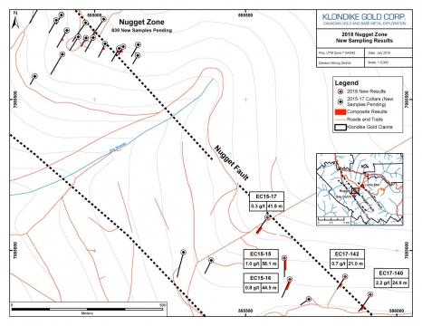
All drill holes originally targeted historical surface or trench occurrences of gold-bearing quartz veins. The holes were drilled in variable southerly orientations, with differing dips, with at least 100 meters between adjacent holes, and staggered across strike. Assay averages are calculated over drilled core lengths; true thickness of any interval is unknown. The reader is cautioned that not enough information is available to correlate lithology or gold mineralization between holes without further drill testing.
These Nugget Zone results warrant follow-up drilling. Re-allocation of drilling in the current 2018 budget is contemplated, with targeting contingent upon receipt of additional Nugget Zone results still pending.
QUALITY ASSURANCE AND METHODS
Klondike Gold maintains a rigorous quality assurance / quality control program. Details can be viewed on the Company’s website http://www.klondikegoldcorp.com/projects/sampling-and-assay-protocols.
Drill core samples are submitted by Klondike Gold personnel to Bureau Veritas Mineral Laboratories (formerly Acme Labs) preparation facility in Whitehorse, YT with chemical analysis of sample pulps completed in Vancouver, British Columbia. Bureau Veritas Labs is an accredited ISO 9001:2008 full-service commercial laboratory.
At BV Labs each core sample is crushed to 80% passing 2 mm size. A 500 g subsample is pulverized to 85% passing -75 microns size (Code PRP70-500). The 500 g subsample is then sieved to 106 microns (140 mesh) for “metallic screen” assaying. The plus 140 mesh fraction is then weighed and assayed for gold by fire assay (“FA”) fusion with a gravimetric finish (Code FS631). A 30 g subsample of the minus 140 mesh fraction is assayed for gold by fire assay (“FA”) fusion with an atomic absorption (“AA”) finish (Code FA430). All over-limit results in excess of 10 ppm (10 g/t) for both silver and gold are re-assayed using a 30 g subsample and assayed by FA with a gravimetric finish (Code FA530-Au/Ag). Total gold grade is then calculated using a weighted average of the plus and minus fraction assay results.
The technical and scientific information contained within this news release has been reviewed and approved by Ian Perry, P.Geol., Vice-President Exploration of Klondike Gold Corp. and Qualified Person as defined by National Instrument 43-101 policy.
ABOUT KLONDIKE GOLD CORP.
Klondike Gold Corp. is a Canadian exploration company with offices in Vancouver, British Columbia, and Dawson City, Yukon Territory. The Company is focused on exploration and development of the Lone Star gold target at the confluence of Bonanza and Eldorado Creeks, within a district scale 553 square kilometer property accessible by government maintained roads located on the outskirts of Dawson City, YT within the Tr’ondëk Hwëch’in First Nation traditional territory.
Rupert Resources Ltd. (TSX:RUP) reports assay results from projec... READ MORE
West Red Lake Gold Mines Ltd. (TSX-V: WRLG) (OTCQB: WRLGF) is ple... READ MORE
Highlights: The Company has received results from drillholes 1274... READ MORE
Highlights Continued strong lithium mineralization over wide inte... READ MORE
Argonaut Gold Inc. (TSX: AR) reported financial and operating res... READ MORE


