


Great Bear Resources Ltd. (TSXV: GBR) (OTCQX: GTBAF) reported results from its ongoing fully funded $45 million 2021 exploration program at its 100% owned flagship Dixie Project in the Red Lake district of Ontario.
Chris Taylor, President and CEO of Great Bear said, “We believe the LP Fault represents one of the largest consistently mineralized new gold discoveries being explored today. We encourage investors to review and compare the LP Fault cross sections provided in this release to those provided on February 8, 2021.”
This news release provides results from 10 new LP Fault drill holes completed along 225 metres of strike length. Great Bear has now published results from 260 LP Fault drill holes and anticipates at least 140 additional LP Fault drill holes will be completed by the end of 2021, for a total of at least 400 drill holes.
Additional drill results provided in this release include: 1) Discovery of a new high-grade vein zone beside the Hinge zone and preparation for directional drilling of the Dixie Limb and Hinge zones, 2) Larger core diameter metallurgical test drilling of the LP Fault, and 3) Regional reconnaissance drilling.
New LP Fault drill results from this release are provided in Table 1, Figure 1, Figure 3, Figure 4 and Figure 5. Table 2 contains drill results from other targets. A new 1.2 kilometre cross section showing all gold zones as drilled to date is provided in Figure 2.
New LP Fault Drill Results
Other Drill Results
Preparation for Dixie Limb and Hinge Zone Directional Drilling
Metallurgical Drilling
Regional Drilling
Table 1: New assay results from the LP Fault, arranged by drill section from southeast to northwest. Note BRH-001 and 002 are larger core diameter metallurgical test holes.
| Drill Hole | From (m) | To (m) | Width* (m) | Gold (g/t) | Section | ||
| BR-254 | 25.50 | 30.45 | 4.95 | 4.95 | 19900 | ||
| BR-255 |
and including and |
22.10
63.00 73.50 271.05 |
52.50
78.75 78.75 274.35 |
30.40
15.75 5.25 3.30 |
4.09
4.35 11.25 4.84 |
19900 | |
| BR-238 |
including and including and |
41.80
55.00 49.10 147.15 |
57.30
57.30 51.10 152.35 |
15.50
2.30 2.00 5.20 |
29.17
54.91 51.73 1.47 |
19975 | |
| BR-244 |
including |
23.85
23.85 |
39.65
25.15 |
15.80
1.30 |
18.08
78.94 |
20000 | |
| BR-246 | 424.30
459.00 |
481.50
460.90 |
57.20
1.90 |
1.82
36.17 |
20000 | ||
| BR-245 |
including and including |
333.90
338.75 397.50 405.00 |
340.85
339.95 426.50 406.60 |
6.95
1.20 29.00 1.60 |
2.19
10.90 5.29 62.13 |
20050 | |
| BRH-001 | 77.75 | 93.00 | 15.25 | 2.33 | 20075 | ||
| BRH-002 |
and |
59.25
154.00 |
63.10
197.55 |
3.85
43.55 |
6.71
0.79 |
20075 | |
| BR-228 | 373.40 | 422.30 | 48.90 | 0.78 | 20125 | ||
| BR-229 | 455.00 | 480.50 | 25.50 | 1.05 | 20125 | ||
* Widths are drill indicated core length, as insufficient drilling has been undertaken to determine true widths at this time. Average grades are calculated with un-capped gold assays, as insufficient drilling has been completed to determine capping levels for higher grade gold intercepts. Interval widths are calculated using a 0.10 g/t gold cut-off grade with up to 3 m of internal dilution of zero grade.
Table 2: Other drill results organized by area.
| Drill Hole | From (m) | To (m) | Width* (m) | Gold (g/t) | Area | |
| DL-063A** | 144.50 | 145.50 | 1.00 | 3.50 | ||
| DL-064 | including
and including and including |
798.65
803.55 1076.25 1076.25 1164.60 1166.00 |
806.40
804.55 1082.45 1077.35 1166.65 1166.65 |
7.75
1.00 6.20 1.10 2.05 0.65 |
1.86
5.46 1.35 4.28 4.41 11.80 |
Dixie Limb
Dixie Limb Hinge Hinge DHZ-FWH DHZ-FWH |
| REG-003 | 390.40 | 394.00 | 3.60 | 0.35 | Regional | |
| REG-004 | and | 630.00
688.00 |
631.50
689.50 |
1.50
1.50 |
0.26
0.64 |
Regional |
| REG-005 | and | 96.50
274.50 |
97.35
275.00 |
0.85
0.50 |
0.64
0.57 |
Regional |
| REG-006 | 352.75 | 353.75 | 1.00 | 0.43 | Regional | |
| REG-007 | 266.45 | 267.00 | 0.55 | 0.32 | Regional | |
| REG-008 | 240.00 | 241.50 | 1.50 | 0.54 | Regional | |
| REG-009 | and | 76.90
562.20 |
83.05
563.20 |
6.15
1.00 |
0.27
0.60 |
Regional |
| REG-010 | No significant values | Regional | ||||
| REG-011 | and
and |
115.50
251.00 279.00 |
117.00
252.00 281.00 |
1.50
1.00 2.00 |
0.55
8.29 0.78 |
Arrow |
* Widths are drill indicated core length, as insufficient drilling has been undertaken to determine true widths at this time. Average grades are calculated with un-capped gold assays, as insufficient drilling has been completed to determine capping levels for higher grade gold intercepts. Interval widths are calculated using a 0.10 g/t gold cut-off grade with up to 3 m of internal dilution of zero grade. ** Hole was abandoned before reaching target depth due to excessive deviation.
Great Bear’s progress can be followed using the Company’s plan maps, long sections and cross sections, and through the VRIFY model posted at the Company’s web site at www.greatbearresources.ca, which will next be updated in Q2 2021. All LP Fault drill hole highlighted assays, plus drill collar locations and orientations can also be downloaded at the Company’s web site.
Drill collar location, azimuth and dip for drill holes included in this release are provided in the table below (UTM zone 15N, NAD 83):
| Hole ID | Easting | Northing | Elevation | Length | Dip | Azimuth |
| BR-228 | 457512 | 5634241 | 366 | 745 | -60 | 207 |
| BR-229 | 457556 | 5634298 | 368 | 633 | -58 | 209 |
| BR-238 | 457506 | 5633874 | 350 | 276 | -51 | 194 |
| BR-244 | 457487 | 5633860 | 351 | 318 | -49 | 206 |
| BR-245 | 457596 | 5634180 | 363 | 675 | -58 | 211 |
| BR-246 | 457651 | 5634177 | 361 | 723 | -63 | 208 |
| BR-254 | 457574 | 5633821 | 353 | 237 | -52 | 204 |
| BR-255 | 457585 | 5633855 | 354 | 339 | -63 | 202 |
| BRH-001 | 457435 | 5633944 | 352 | 147 | -55 | 204 |
| BRH-002 | 457467 | 5634028 | 353 | 249 | -48 | 201 |
| DL-063A | 456723 | 5633985 | 362 | 741 | -60 | 225 |
| DL-064 | 456790 | 5633950 | 359 | 1188 | -54 | 222 |
| REG-003 | 456059 | 5634396 | 369 | 561 | -55 | 220 |
| REG-004 | 456214 | 5634182 | 376 | 714 | -50 | 240 |
| REG-005 | 455339 | 5634318 | 373 | 540 | -55 | 218 |
| REG-006 | 455145 | 5633967 | 361 | 556 | -55 | 217 |
| REG-007 | 454953 | 5633693 | 359 | 516 | -55 | 214 |
| REG-008 | 455602 | 5633733 | 364 | 493 | -60 | 219 |
| REG-009 | 455737 | 5634007 | 363 | 699 | -56 | 209 |
| REG-010 | 456380 | 5636480 | 407 | 510 | -55 | 204 |
| REG-011 | 455601 | 5633940 | 363 | 468 | -60 | 220 |
About the Dixie Project
The Dixie Project is 100% owned, comprised of 9,140 hectares of contiguous claims that extend over 22 kilometres, and is located approximately 25 kilometres southeast of the town of Red Lake, Ontario. The project is accessible year-round via a 15 minute drive on a paved highway which runs the length of the northern claim boundary and a network of well-maintained logging roads.
The Dixie Project hosts two principal styles of gold mineralization:
About Great Bear
Great Bear Resources Ltd. is a well-financed gold exploration company managed by a team with a track record of success in mineral exploration. Great Bear is focused on the prolific Red Lake gold district in northwest Ontario, where the company controls over 330 km2 of highly prospective tenure across 5 projects: the flagship Dixie Project (100% owned), the Pakwash Property (earning a 100% interest), the Dedee Property (earning a 100% interest), the Sobel Property (earning a 100% interest), and the Red Lake North Property (earning a 100% interest) all of which are accessible year-round through existing roads.
QA/QC and Core Sampling Protocols
Drill core is logged and sampled in a secure core storage facility located in Red Lake Ontario. Core samples from the program are cut in half, using a diamond cutting saw, and are sent to Activation Laboratories in Ontario, an accredited mineral analysis laboratory, for analysis. All samples are analysed for gold using standard Fire Assay-AA techniques. Samples returning over 10.0 g/t gold are analysed utilizing standard Fire Assay-Gravimetric methods. Pulps from approximately 5% of the gold mineralized samples are submitted for check analysis to a second lab. Selected samples are also chosen for duplicate assay from the coarse reject of the original sample. Selected samples with visible gold are also analyzed with a standard 1 kg metallic screen fire assay. Certified gold reference standards, blanks and field duplicates are routinely inserted into the sample stream, as part of Great Bear’s quality control/quality assurance program (QAQC). No QAQC issues were noted with the results reported herein.
Qualified Person and NI 43-101 Disclosure
Mr. R. Bob Singh, P.Geo, VP Exploration, and Ms. Andrea Diakow P.Geo, Exploration Manager for Great Bear are the Qualified Persons as defined by National Instrument 43-101 responsible for the accuracy of technical information contained in this news release.
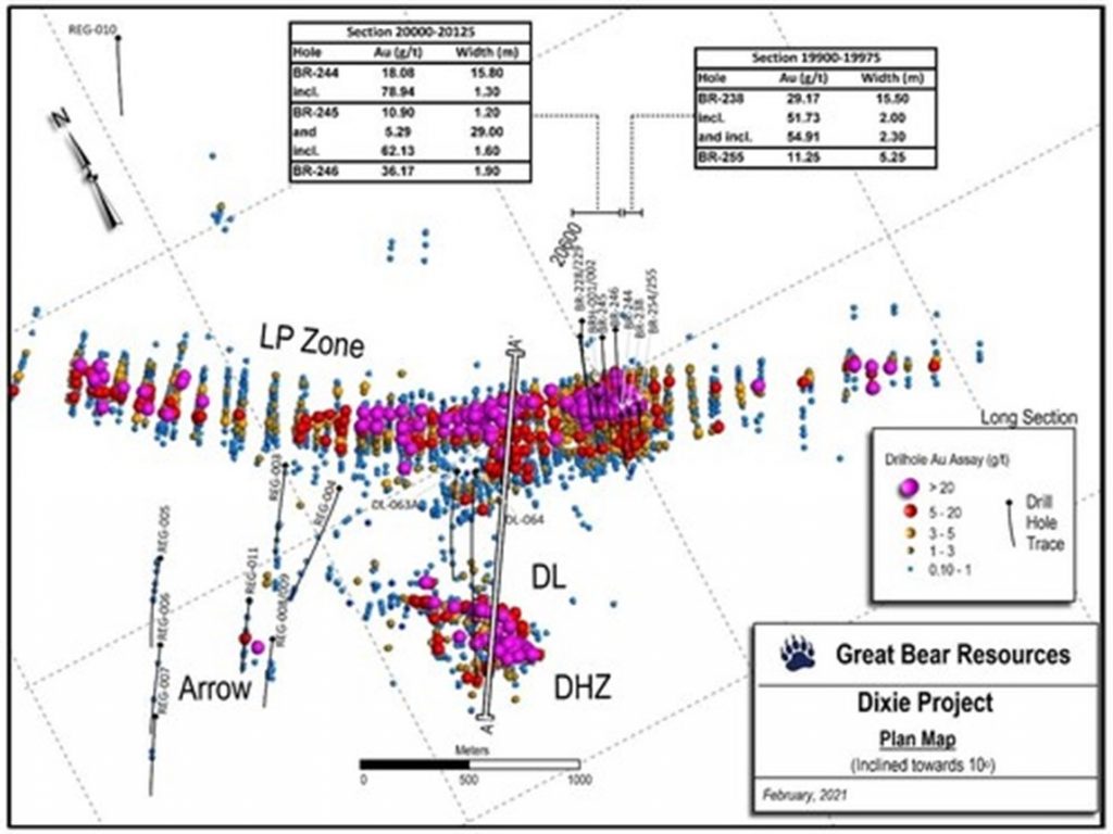
Figure 1: Map of current drill results showing the location of the new 1.2 kilometre cross section. (CNW Group/Great Bear Resources Ltd.)
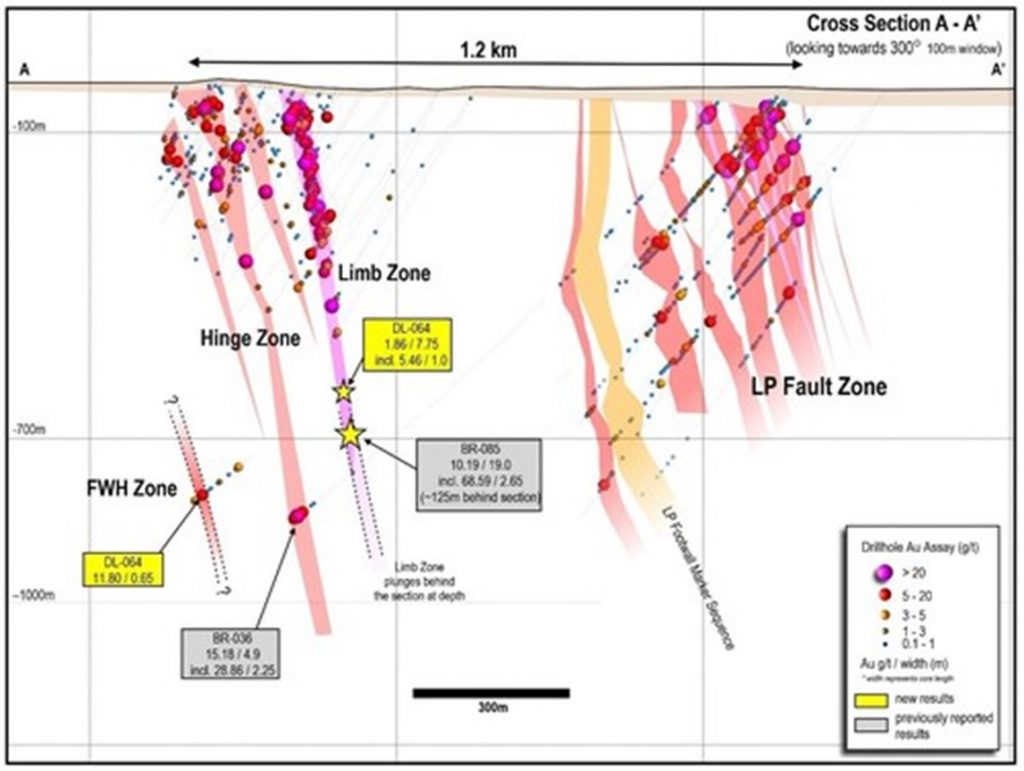
Figure 2: Updated 1.2 kilometre cross section showing multiple sub-parallel gold zones as drilled to date at Dixie, based on approx. 460 drill holes reported by Great Bear (located on Figure 1). The new high-grade vein zone (FWH) discovery beside the Hinge zone is shown. (CNW Group/Great Bear Resources Ltd.)
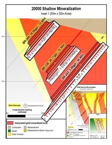
Figure 3: Near-surface gold results on drill section 20000. All individual assays are shown. 50 x 50 m view. (CNW Group/Great Bear Resources Ltd.)
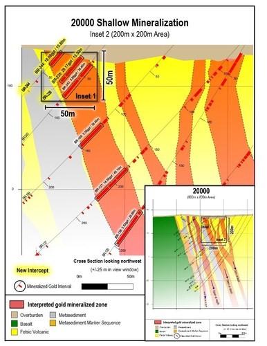
Figure 4: Shallow gold results from drill section 20000. 200 x 200 m view. (CNW Group/Great Bear Resources Ltd.)
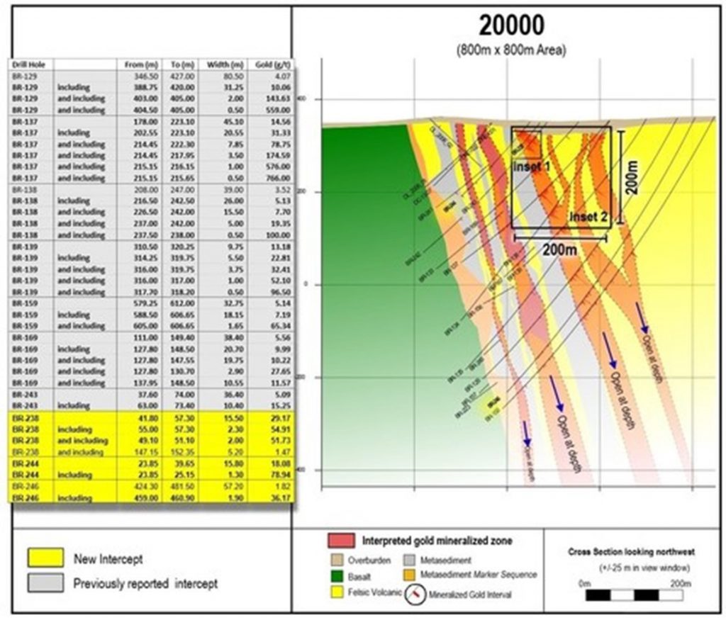
Figure 5: Complete drill section 20000 as drilled to date, showing insets of previous figures and highlights of past and current drilling. 800 x 800 m view. (CNW Group/Great Bear Resources Ltd.)
Significant copper and molybdenum intersections include: HM09: 13... READ MORE
Aya Gold & Silver Inc. (TSX: AYA) (OTCQX: AYASF) is pleased t... READ MORE
Key Highlights – Preliminary Economic Assessment Pre-Tax Net Pr... READ MORE
Aris Mining Corporation (TSX: ARIS) (NYSE-A: ARMN) announces its ... READ MORE
Orla Mining Ltd. (TSX: OLA) (NYSE: ORLA) announces the results fo... READ MORE


