


Alaska Silver Corp. (TSX-V: WAM) (OTCQX: WAMFF), is pleased to announce a fully-funded intensive summer 2026 exploration program – including a minimum of 6000 m of diamond drilling- for its 32,737-hectare (80,895 acre), 100%-owned Illinois Creek Silver-Gold-Lead-Zinc and Gallium project located in western Alaska. The Company will utilize two company-owned drill rigs, with simultaneous surface exploration and trenching. Activity should begin in early June.
The 2026 drilling program will focus on multiple priority targets at the high-grade Waterpump Creek deposit and the newly discovered Silver Sage Zone, along with scout drilling of other high priority targets. Building on 2025’s successful discovery of the blind Silver Sage Zone, systematic follow up of legacy and newly generated geochemical and geophysical anomalies will be undertaken in high-potential areas identified within the overall Illinois Creek Project area.
“With two drills turning and geologist’s boots on the ground throughout the season, this will be our most aggressive summer program in our history,” said Kit Marrs, President and CEO of Alaska Silver. “Prime drilling objectives are expanding the Waterpump Creek resource and finding the source of Silver Sage while we trench and do initial drilling of newly recognized targets throughout the Illinois Creek property.”
2026 Waterpump Creek
Alaska Silver has delineated a significant high-grade Ag-Pb-Zn Inferred Resource at Waterpump Creek with a grade of 980 grams per tonne silver equivalent (see press release dated February 22, 2024), interpreted to be part of a much larger integrated Carbonate Replacement Deposit system. This resource terminates abruptly against a post-mineral fault making finding the continuation of the mineralization across the fault a prime target. The Company’s limited 2025 Waterpump Creek program consisted of only four drill holes totaling 2,057 m (See press release dated January 20, 2026). Two holes intersected the post-mineral fault zone, providing critical insight into the structural architecture of the area and the conduits that focused mineralizing fluids into carbonate-hosted traps (Figure 1). Two other holes intersected altered carbonate host rocks south of the fault, which clearly indicates that mineralization continues south of the post-mineral fault. Aggressive drilling is planned for 2026 to better understand the structure, locate mineralization in the south block and follow that mineralization back towards its source.
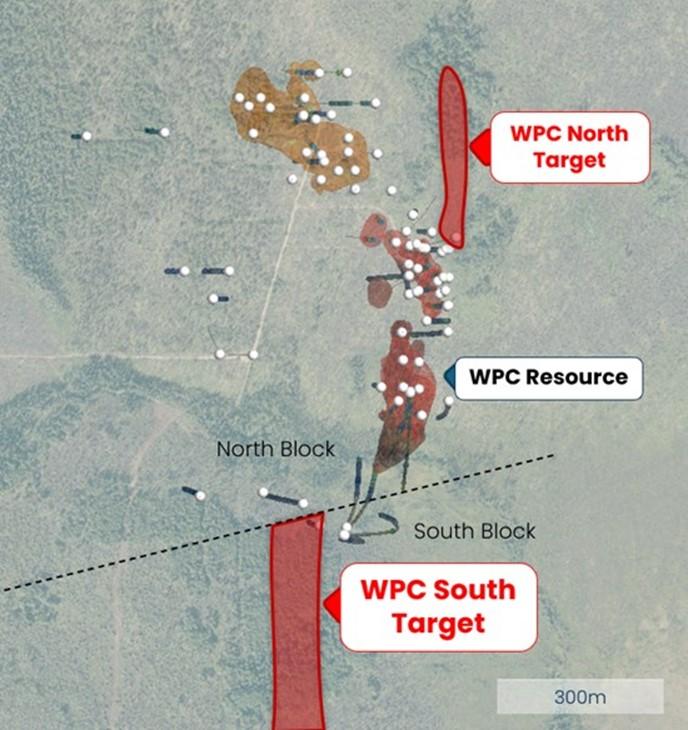
Figure 1. Map of the Waterpump Creek area with 2026 target areas illustrated in red.
2026 Silver Sage
Alaska Silver discovered the Silver Sage zone in early July 2025 through trenching along a 1.5 km-long trend of untested historical soil anomalies (See Press Release of November 3, 2025). The work outlined a 550 m-long, deeply weathered breccia zone containing silver-bearing galena and cerussite (lead carbonate mineral). Trench sampling returned numerous high-grade silver-lead results, including multiple samples above 310 g/t silver (10 oz/ton) and values up to 1,235 g/t silver (40 oz/ton), with gold values reaching 0.55 g/t. Silver Sage is interpreted as another key mineralization center within the overall Illinois Creek-Waterpump Creek CRD system.
Initial 2025 drilling comprised nine short, widely spaced holes totaling 906.5 m, designed to determine stratigraphy and structural controls (Figure 2). Four holes intersected significant localized silver and lead mineralization with anomalous zinc, gold exceeding 1 g/t locally, and copper locally approaching 1%. This shallow drilling program showed that mineralization is thoroughly oxidized, with evidence of zinc leaching, and is hosted at the top of reactive carbonate rocks beneath an impermeable schist horizon, consistent with a CRD setting.
Based on the 2025 results, Alaska Silver has designed a 2026 summer drilling program to target the feeder structures for Silver Sage and locate coherent sulfide mineralization at depth.
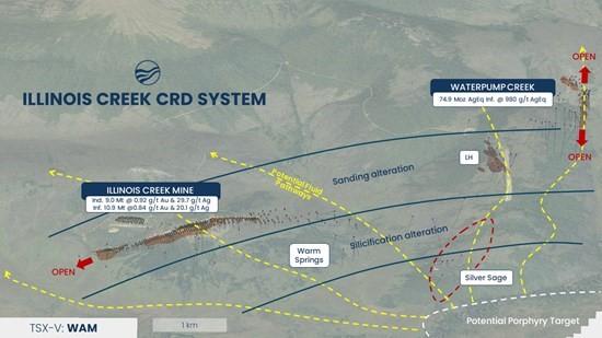
Figure 2. Illinois Creek Spoke Model Regional Map
Regional Field Exploration: Two CRD-Porphyry Systems in the District
In addition to the planned drilling at Waterpump Creek and Silver Sage, Alaska Silver will advance a regional exploration initiative during the 2026 field season, reflecting the Company’s evolving interpretation of the Illinois Creek district as having two carbonate replacement deposit-porphyry (“CRD-PPY”) centers. with significant CRD potential developed within reactive carbonate stratigraphy surrounding each center. The first center (or “hub”) is the well-established Illinois Creek system, where multiple components of a large CRD system have been identified, including the Waterpump Creek-Pb-Zn resource, the Illinois Creek Au-Ag resource, Silver Sage, Warm Springs, and other prospects. While the intrusive center responsible for mineralization at Illinois Creek has not yet been located, the geological, structural, geophysical and geochemical evidence strongly supports its presence at depth. 2026 will see continued exploration for CRD mineralization in the Illinois Creek system to connect the dots along this major 8-km long mineralization corridor.
The second hub is centered on the Round Top Ag-Cu-Mo porphyry, located approximately 20 km from the Illinois Creek system. In contrast to Illinois Creek, the Round Top system exposes a well-defined mineralized intrusive porphyry center surrounded by extensive carbonate host rocks that exhibit strong, widespread geochemical leakage to surface, including highly anomalous silver, lead, and zinc values over multi-kilometer strike lengths.
Within the Round Top hub, the TG and TG North (“TGN”) CRD prospects represent high-priority targets and will be a primary focus for one of the Company’s 2026 field exploration teams (Figure 3). Soil geochemistry outlines a strongly anomalous Ag-Pb-Zn trend extending over more than 5 km, with numerous samples exceeding 1,000 ppm lead, indicative of a robust and fertile mineralizing system. Reconnaissance mapping has identified multiple carbonate horizons interlayered with schist cap rocks, forming favorable stratigraphic and structural traps analogous to those hosting high-grade mineralization at Waterpump Creek.
The Company believes the TG/TGN area has strong potential to host Waterpump Creek-style CRD mineralization, developed peripheral to the Round Top intrusive center. Planned 2026 work will include detailed geological mapping, targeted soil and sub-surface sampling, trenching, and refinement of drill targets to test for high-grade CRD mineralization beneath the soil geochemical anomalies.
Together, the Illinois Creek and Round Top hubs define a district-scale exploration opportunity, significantly expanding the Company’s target inventory and discovery potential across the Project.
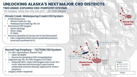
Figure 3. Location of the Round Top hub, the TG and TG North CRD prospects
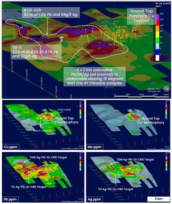
Figure 4. TGN Exploration Target Geochemistry
Qualified Person
Patrick Donnelly P.Geo, Executive Vice President of Alaska Silver, a Qualified Person under National Instrument 43-101, has reviewed and approved the scientific and technical information in this news release.
About Alaska Silver
Alaska Silver is a junior exploration company focused on the discovery and development of high-grade silver, gold and critical metals assets within one of North America’s major high-grade silver and critical minerals districts at their Illinois Creek (IC) Project in western Alaska. Illinois Creek is a contiguous, 100%-owned land package totaling 80,895 acres (126.40 square miles or 32,337 hectares) anchored by two resource-level mineralization zones separated by 8 km of high potential exploration ground. At one end lies the high-grade silver mineralization at the Waterpump Creek zone, which hosts an Inferred Mineral Resource of 75 Moz AgEq at a grade of 279 g/t silver, 11.28 % zinc and 9.87% lead¹, ² that remains open to the north and south, as well as by the Illinois Creek mine. At the western end is the historically produced Illinois Creek mine that closed due to low metal prices leaving untouched Indicated Mineral Resources of 260,000 oz gold at 0.92 g/t Au and 8.3 Moz silver at 29.72 g/t Ag, along with Inferred Mineral Resources of 290,000 oz gold at 0.84 g/t Au and 10.4 Moz silver at 30.11 g/t Ag2, 3. The IC Project is located approximately 38 kilometers from the Yukon River, the region’s primary marine transportation corridor, and comprises Headquartered in Alaska and Arizona, Alaska Silver is led by a team with a proven track record of large-scale mine discoveries.
1 For Waterpump Creek, the formulas for AgEq are AgEq (g/t)= Ag (g/t) + 28.56 x Pb(%) + 37.12 x Zn(%) and assume metal prices of US$24/oz Ag, US$1.30/lb Zn, and US$ 1.00/lb Pb.2
2 Please refer to the NI 43-101 Technical Report titled “Illinois Creek Project, Western Alaska, USA” dated February 25, 2026 (effective date of January 22, 2026).
3 For Illinois Creek, AuEq values are based only on gold and silver values using metal prices of US$3,500/oz Au and US$45/oz Ag.
Imperial Metals Corporation (TSX:III) reports copper and gold p... READ MORE
Aldebaran Resources Inc. (TSX-V: ALDE) (OTCQX: ADBRF) and its maj... READ MORE
Nevada Sunrise Metals Corporation (TSX-V: NEV) (OTC Pink: NVSGF)... READ MORE
Newmont Corporation (NYSE: NEM) (ASX: NEM) (PNGX: NEM) announced ... READ MORE
Scorpio Gold Corporation (TSX-V: SGN) (OTCQB: SRCRF) (FSE: RY9) i... READ MORE


