








Regional Exploration Confirms VMS Cluster Potential Beyond B26 in Proven VMS Camp
Abitibi Metals Corp. (CSE: AMQ) (OTCQB: AMQFF) (FSE: FW0) is pleased to announce regional exploration results from its 100%-owned B26 Polymetallic Property in Québec, highlighted by hole 1274-26-383, which intersected a new potential volcanogenic massive sulphide zinc-silver mineralized zone approximately 1.5 kilometres west of the B26 Deposit at 400 metres vertical depth. The 3,285-metre program, Abitibi’s first systematic test of the Property’s regional potential, targeted three of seven high-priority areas identified through a reinterpretation of historical drilling, legacy induced polarization surveys and the Company’s 2025 VTEM-MAG airborne survey (Figure 1). Abitibi now owns 100% of the B26 Project after exercising its option to acquire the remaining interest from SOQUEM Inc., a subsidiary of Investissement Québec (see news release dated June 11, 2026).
Highlights include:
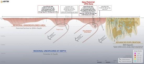
Figure 1. Longitudinal Section Looking North – 2026 Regional Drilling Results
Jonathon Deluce, CEO of Abitibi Metals, commented: “We are highly encouraged by these initial regional exploration results at B26. This program marks a milestone for the Company, representing the first step in a systematic exploration strategy beyond the immediate brownfield footprint of the B26 Deposit. Hole 1274-26-383 confirms a zinc-silver system hosted in the same felsic volcanic package as the B26 Deposit, and we are increasingly seeing evidence that this is part of a broader cluster of mineralized systems, which we intend to keep testing. Given this setting, the potential for new lenses comes as no surprise, and these results support our conviction that we are at the early stages of building a world-class VMS camp. While expanding the B26 Deposit remains our primary objective, discoveries like this, returned from just 400 metres vertical depth, demonstrate our ability to create meaningful long-term value for our shareholders. This progress also reflects the strength of our exploration team, which is really starting to grow and come together, and its growing ability to add value across the Property.”
Table 1 – Mineral Intercepts from Regional Drilling
| Drill hole | From (m) | To (m) | Interval (m) | CuEq 2026 % | Cu (%) | Au (g/t) | Ag (g/t) | Zn (%) | CuEq Spot % |
| 1274-26-382 | 486.30 | 490.55 | 4.30 | 0.12 | 0.00 | 0.00 | 2.78 | 0.29 | 0.12 |
| Incl. | 486.30 | 486.75 | 0.50 | 0.52 | 0.01 | 0.00 | 3.80 | 1.49 | 0.45 |
| 1274-26-383 | 455.75 | 470.00 | 14.25 | 0.74 | 0.01 | 0.03 | 51.51 | 1.13 | 1.07 |
| Incl. | 456.65 | 459.75 | 3.10 | 1.73 | 0.00 | 0.01 | 120.64 | 2.82 | 2.48 |
| Incl. | 466.50 | 470.00 | 3.50 | 1.18 | 0.02 | 0.11 | 82.49 | 1.61 | 1.74 |
| 1274-26-383 | 468.00 | 470.00 | 2.00 | 1.53 | 0.02 | 0.11 | 106.10 | 2.18 | 2.23 |
| And | 537.30 | 538.40 | 1.10 | 0.70 | 0.55 | 0.03 | 16.80 | 0.03 | 0.84 |
| 1274-26-384 | 344.30 | 344.75 | 0.50 | 0.24 | 0.00 | 0.04 | 29.20 | 0.01 | 0.47 |
| And | 384.00 | 385.50 | 1.50 | 0.23 | 0.00 | 0.04 | 24.57 | 0.08 | 0.42 |
| And | 417.30 | 419.00 | 1.70 | 0.31 | 0.24 | 0.02 | 2.54 | 0.10 | 0.32 |
| 1274-26-385 | 462.00 | 470.85 | 8.85 | 0.47 | 0.02 | 0.11 | 21.21 | 0.68 | 0.62 |
| Incl. | 463.50 | 468.20 | 4.70 | 0.68 | 0.02 | 0.16 | 26.03 | 1.04 | 0.84 |
| And | 501.00 | 502.00 | 1.00 | 3.01 | 0.01 | 0.83 | 332.00 | 0.17 | 5.72 |
Note 1: The intercepts above are not necessarily representative of the true width of mineralization. Local interpretation indicates that the mineralized lens’ true width generally corresponds to 60% to 80% of core length.
Note 2: Copper equivalent (CuEq 2026) values are calculated using metal prices of US$4.50/lb Cu, US$1.50/lb Zn, US$28.00/oz Ag and US$3,000/oz Au, with recoveries per the SGS CACGS-P2017-047 metallurgical test: 98.3% Cu, 90.0% Au, 96.1% Zn, 72.1% Ag.
Note 3: Intervals are generally composited using a 0.1% Zn cut-off, allowing up to three consecutive samples below cut-off grade.
Note 4: CuEq Spot values are calculated using metal prices of US$5.60/lb Cu, US$1.50/lb Zn, US$75.00/oz Ag and US$4,650/oz Au, with the same recovery factors as Note 2.
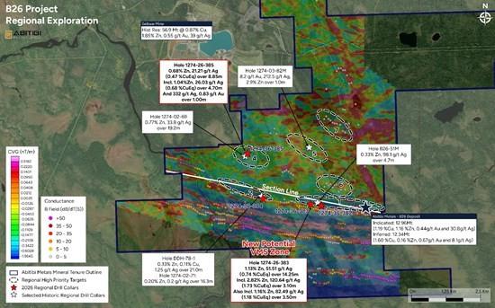
Figure 2. Plan Map of B26 Regional Exploration Targets
Discussion of Results
The 2026 regional drilling program tested downdip extension of shallow historical zinc-silver anomalies at approximately 400 metres vertical depth across three of the Property’s seven identified priority targets (Figure 1). Only four drill holes have been completed to date, underscoring the early stage of this exploration effort on a property where historical drilling remains largely limited to the upper 200 metres, with no prior holes testing the system at 400 metres vertical depth outside of the B26 Deposit itself (Figure 2).
The most encouraging results were returned from Target 1 (Figure 1), which covers the western extension of the B26 stratigraphic horizon over approximately 1.5 kilometres west of the current deposit. This corridor exhibits the same subdued magnetic signature as the B26 Deposit and includes historical drill hole B26-51M, which intersected 0.33% Zn and 98.1 g/t Ag over 4.7 metres within a B26-style alteration system that was never followed up. Two holes tested this corridor, approximately 500 metres and 1,500 metres west of the deposit; the latter, hole 1274-26-383, intersected 1.13% Zn and 51.51 g/t Ag over 14.25 m starting at 455.75 m depth, including 2.82% Zn and 120.64 g/t Ag over 3.10 m and 1.61% Zn and 82.49 g/t Ag over 3.50 m. The Zn-Ag mineralization is hosted in pyritized, locally semi-massive felsic ash and lapilli tuffs affected by medium to strong sericite, silica and iron carbonate alteration, the same host-rock package and alteration style as the B26 deposit sequence, though here it is more intensely altered and moderately foliated, distinguishing this occurrence from B26 itself.
Approximately 70 metres farther downhole to the north, hole 1274-26-383 also intersected a separate copper-rich interval grading 0.55% Cu over 0.60 metres associated with chalcopyrite stringers and black chlorite alteration, the signature style of the Cu Stringer zone at B26. Although narrow, this copper occurrence reproduces the same metal zonation observed at B26, where the zinc-silver-rich horizon sits adjacent to the main copper-gold-rich horizon. This architecture strengthens the interpretation that Target 1 hosts a fertile VMS system analogous to, but distinct from, B26, a new mineralized lens that remains open in all directions.
Approximately 5 kilometres farther west, Target 2 tested a 1.5-kilometre-long VTEM conductor hosted within the same favourable felsic volcanic sequence as B26. Historical drilling returned broad polymetallic halos, including 0.33% Zn, 0.11% Cu and 1.25 g/t Ag over 21.0 metres, suggesting leakage from a larger mineralized system at depth. The 2026 drill hole confirmed the favourable geological setting at 400 metres vertical depth and will be followed by downhole Pulse EM surveying to evaluate potential off-hole conductors.
The fourth hole tested Target 4 located approximately 4.5 kilometres northwest of B26, where historical drilling outlined an open zinc-silver mineralized system associated with a strong IP anomaly, including 0.77% Zn and 33.8 g/t Ag over 19.2 metres. The hole intersected additional sulphide mineralization at 400 metres vertical depth, confirming the continuation of the system and providing another platform for follow-up Pulse EM surveys. It also returned a high-grade precious metals intercept of 332 g/t Ag and 0.83 g/t Au over 1.0 metre from 501 metres downhole, pointing to an added precious-metals component to the regional potential. This result will be evaluated alongside other historical high-grade intercepts on the Property, including hole 1274-03-82M, which returned 8.2 g/t Au, 212.5 g/t Ag and 2.9% Zn over 1.0 metre at Target 5 (Figure 1). Beyond these targets, several highly prospective areas remain untested, including additional precious metal targets north of B26 and newly defined Targets 5 – 7 (Figure 1), which outline a separate VMS corridor extending toward the former Selbaie Mine.
Overall, this program represents only an initial test of the Property’s regional potential (Figure 2). While Targets 2 and 4 confirmed the continuation of known mineralized systems at 400 metres vertical depth, hole 1274-26-383 stands out as the key exploration success, pointing to a mineralized lens west of the B26 Deposit that is geologically related to, yet distinct from, B26 itself. Combined with the Property’s limited historical drilling and numerous untested targets, these results reinforce the significant regional exploration upside of the B26 Property. A follow-up program is being designed for execution in winter 2027, when frozen ground conditions allow access to the drill sites.
Table 2 – Regional Drill Hole Information
| Hole ID | UTM East | UTM North | Elevation | Azimuth | Dip | Start (m) | End (m) |
| 1274-26-382 | 651453 | 5513200 | 271 | 350 | -60 | 0 | 813 |
| 1274-26-383 | 651047 | 5513241 | 269 | 350 | -60 | 0 | 835 |
| 1274-26-384 | 649329 | 5513597 | 265 | 0 | -70 | 0 | 813 |
| 1274-26-385 | 648750 | 5515157 | 265 | 355 | -67 | 0 | 824 |
Note 1: Numbers have been rounded to the nearest whole number in the table above.
Quality Control & Quality Assurance
Core logging and QA/QC protocols were run and supervised by the Company’s technical team. Drill core was split in half and sent to AGAT Laboratories Ltd., with sample preparation in Val-d’Or, fire assay in Thunder Bay and 4-acid digestion / multi-element analysis in Calgary. Prepared samples are fused using standard fire assay techniques, cupelled and parted in nitric and hydrochloric acid; sample splits of 30 g are routinely used, though 50 g may also be used (AGAT Code 202 551). A 0.2 g split of each prepared sample is digested in a series of acids (HClO4, HF, HCl and HNO3) at approximately 200°C to incipient dryness, then heated with HNO3 and HCl and diluted to 12 mL with de-ionized water. Because solubility can depend on the mineral species present, data reported from 4-acid digestion represent only the leachable portion of a given analyte; some elements (B, As, Hg) show poor recovery due to volatilization. Analyses are run on PerkinElmer 7300DV/8300DV and Agilent 5900 ICP-OES instruments, with Inter-Element Correction applied to correct for spectral interferences, and AAS instruments used where applicable. Blanks, replicates, duplicates and internal reference materials are routinely inserted as part of AGAT’s quality assurance program.
Qualified Person
Louis Gariépy, P.Eng. (OIQ #107538), VP Exploration of Abitibi Metals, is the Qualified Person, as defined by National Instrument 43-101 – Standards of Disclosure for Mineral Projects, for the B26 Polymetallic Property. He has reviewed and approved the scientific and technical information contained in this press release.
About Abitibi Metals Corp.
Abitibi Metals Corp. is dedicated to acquiring and exploring mineral properties within Quebec, with a particular emphasis on high-quality base and precious metal assets that offer significant potential for growth and expansion.
The company’s flagship B26 Polymetallic project hosts a substantial and growing resource base1:
The B26 Project is strategically located just 7 km southeast of the formerly producing Selbaie Mine, providing access to key infrastructure for potential future mine development.
Brutus Mining Inc. (CSE: BRU) (FSE: ZI3) is pleased to announce that it has closed its non-brokered ... READ MORE
Jaguar Uranium Corp. (NYSE American: JAGU) is pleased to announce an independent Mineral Resource E... READ MORE
Auro Metals Inc. (TSX-V: AURO) (OTCQB: AURFF), is pleased to announce the assay results of the fina... READ MORE
Endeavour Silver Corp. (NYSE: EXK) (TSX: EDR) is pleased to announce that repairs to the primary bal... READ MORE
Scorpio Gold Corp. (NASDAQ: SGLD) (TSX-V: SGLD) (OTCQB: SRCRF) (FSE: RY9) is pleased to announce re... READ MORE


