








Yukon Metals Corp. (CSE: YMC) (FSE: E770) (OTCQB: YMMCF) is pleased to report results from a successful 2025 diamond drilling program at the Star River property located adjacent to the past-producing Ketza mine in the southern Yukon, motivating the acquisition of additional, highly prospective, Stump claims along the same structural corridor.
The 2025 drill campaign focused on testing the down-dip and along-strike extensions of gold and silver-bearing veins exposed at surface within the F2, F3 and Saddle zones. Holes successfully correlated geology with geophysical surveys, including electromagnetics, gravimetry and drone magnetics defining a 1-kilometre-long structural mineralized corridor containing multiple exploration targets.
Highlights
*Note that mineralization is from a high-grade, narrow-vein system such that most of the holes only intersect with a meter or so per hole of each targeted vein, while the rest of the hole sought to define deeper system geology. The average concentrations for each hole can be found in Table 1, below.
“Results from our first drill program at Star River represent an important step toward defining a district-scale polymetallic vein system within the Ketza district,” commented Jim Coates, CEO of Yukon Metals. “We successfully intersected the targeted vein systems and confirmed the presence of a polymetallic hydrothermal system. The program returned encouraging gold values, including up to 11.7 grams per tonne gold in vein material, and intersected silver-lead mineralization consistent with the surface vein exposures. Based on successful drilling, we acquired the additional Stump claims, expanding the land package to cover multipl e mineralized vein systems along a highly prospective structural corridor, while adding an additional silver-lead vein target.”
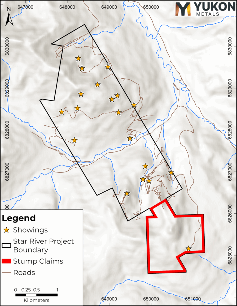
Figure 1- Star River area with highlighted newly acquired Stump claims to the south.
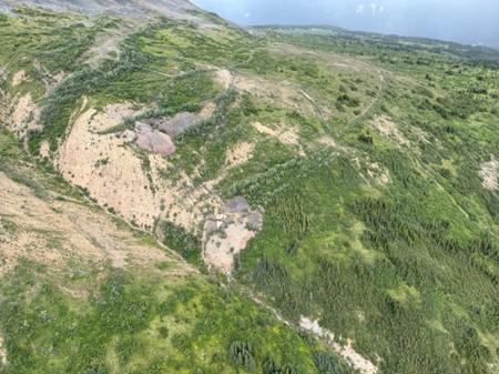
Figure 2- View of historic trenching on the Stump claims.
Next Steps
The Company is integrating geological, geochemical and geophysical data from the 2025 program to refine the structural model of the F2 corridor and prioritize follow-up work. Future work will focus on testing additional vein splays along the F2 structure, particularly where structural preparation coincides with calcium-rich metasedimentary units interpreted to be favourable hosts for gold mineralization. The newly acquired Stump vein claims represent a priority exploration target.
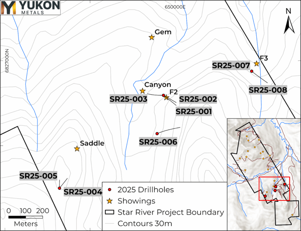
Figure 3- 2025 Star River drill hole locations and inset map showing new Stump claims to the south.
Geology and Mineralization
Drilling in the F2, F3 and Saddle zones intersected a metasedimentary sequence comprising quartzite and phyllitic metasediments separated by graphitic schist horizons within the Cassiar Platform stratigraphy. Mineralization occurs primarily within brecciated and veined intervals developed in calcium-rich metasedimentary units, indicating that structurally prepared reactive host rocks played an important role in localizing hydrothermal fluid flow.
Holes SR25-001, 002, and 003 drilled near the F2 vein showing intersected gold mineralization in massive quartz–ankerite veins containing pyrite and arsenopyrite, returning values of up to 11.7 g/t Au and several veins returning between 1 .9-4.9 g/t Au. Multielement analysis indicates a strong Au–As–Fe association, with elevated gold values correlating with Ca-rich host rocks and Ca-dominant geochemical ratios. In addition, a second set of narrow polymetallic veins containing galena returned values of up to 183 g/t Ag and 10.6% Pb.
Hole SR25-006 south of the F2 vein area is thought to be separated by an offsetting fault intersected three 1.5-metre-long intervals of elevated zinc between 2.4-3.4% within brecciated and veined intervals hosted in phyllitic and calcareous metasediments. These results together indicate a multiphase polymetallic hydrothermal system within the F2 corridor.
Holes SR25-004 and 005 drilled in the Saddle zone primarily intersected fault breccia and gouge material, with portions extremely oxidised. Core recovery was low in these holes, and one section of low-grade gold mineralization was intersect ed in hole 4 associated with the fault.
Holes SR25-007 and 008 targeted the F3 vein showing on the east side of the Star River Property intersected silver and lead-bearing vein breccias up to 116 g/t Ag and up to 3.2% Pb. Near the bottom of hole 008, a zinc rich interval was intersected that may be related to mineralization in Hole 6 to the west.
Current modelling indicates that the F2 vein system represents the principal mineralized structure linking the majority of Au, Ag and Pb intercepts to mapped surface veins. Individual veins strike predominantly north–south, while geophysical data define a broader east–west structural corridor interpreted to represent a major deformation zone across the Property. Gold mineralization is preferentially developed where veining and brecciation intersect calcium-rich metasedimentary units, suggesting that structural preparation and reactive host lithologies together controlled t he localization of mineralization. At depth and along strike the F2 structure appears to bifurcate into multiple splays, forming a distributed vein network.
Table 1- 2025 Star River Drilling Highlights
| Hole ID | From (m) | To (m) | Length (m) | Au g/t | Ag g/t | Pb % | Zn % | ||||||||
| SR25-001 | 28.5 | 29.0 | 0.5 | 0.1 | 183.0 | 10.6 | 0.0 | ||||||||
| SR25-001 | 52.0 | 53.0 | 1.0 | 2.0 | 0.3 | 0.0 | 0.0 | ||||||||
| SR25-001 | 79.5 | 81.0 | 1.5 | 0.0 | 29.5 | 1.9 | 0.0 | ||||||||
| SR25-001 | 99.1 | 99.6 | 0.5 | 11.7 | 3.5 | 0.0 | 0.0 | ||||||||
| SR25-002 | 13.5 | 31.5 | 18.0 | 0. 0 | 10.3 | 0.4 | 0.0 | ||||||||
| incl | 27.0 | 31.5 | 4.5 | 0.0 | 26 | 1.4 | 0.0 | ||||||||
| SR25-002 | 65.1 | 82.0 | 16.9 | 0.8 | 3.2 | 0.1 | 0.0 | ||||||||
| incl | 69.6 | 71.0 | 0.6 | 4.9 | 1.9 | 0.0 | 0.0 | ||||||||
| incl | 71.0 | 71.7 | 0.7 | 2.0 | 13.1 | 0.6 | 0.0 | ||||||||
| incl | 78.0 | 79.0 | 1.0 | 1.9 | 1.3 | 0.0 | 0.0 | ||||||||
| incl | 79.0 | 80.0 | 1.0 | 1.9 | 1.0 | 0.0 | 0.0 | ||||||||
| SR25-002 | 228.0 | 229.5 | 1.5 | 0.0 | 5.8 | 0.6 | 0.7 | ||||||||
| &n bsp; | |||||||||||||||
| SR25-003 | 16.0 | 17.0 | 1.0 | 0.0 | 30.5 | 1.7 | 0.0 | ||||||||
| SR25-003 | 19.0 | 20.0 | 1.0 | 0.0 | 131.0 | 5.8 | 0.0 | ||||||||
| SR25-003 | 42.0 | 43.5 | 1.5 | 0.0 | 34.7 | 0.0 | 0.0 | ||||||||
| &n bsp; | |||||||||||||||
| SR25-004 | 67 | 68 | 1 | 0.3 | 3.7 | 0 | 0 | ||||||||
| SR25-004 | 68 | 69 | 1 | 0.2 | 2.2 | 0 | 0 | ||||||||
| SR25-004 | 69 | 69.5 | 0.5 | 0.2 | 1.9 | 0 | 0 | ||||||||
| SR25-004 | 72 | 73 | 1 | 0.2 | 0.25 | 0 | 0 | ||||||||
| SR25-004 | 73 | 74 | 1 | 0.2 | 0.25 | 0 | 0 | ||||||||
| SR25-004 | 74 | 74.7 | 0.7 | 0.3 | 2 | 0 | 0 | ||||||||
| SR25-005 | No significant results | ||||||||||||||
| SR25-006 | 254.5 | 256.0 | 1.5 | 0.0 | 7.1 | 0.6 | 3.4 | ||||||||
| SR25-006 | 258.0 | 259.5 | 1.5 | 0.0 | 2.3 | 0.1 | 2.4 | ||||||||
| SR25-006 | 268.5 | 270.0 | 1.5 | 0.0 | 5.1 | 0.4 | 3.0 | ||||||||
| SR25-007 | 25.5 | 27.0 | 1.5 | 0.0 | 116.0 | 0.6 | 0.0 | ||||||||
| SR25-008 | 39.0 | 40.5 | 1.5 | 0.1 | 80.1 | 2.7 | 0.0 | ||||||||
| SR25-008 | 40.5 | 42.0 | 1.5 | 0.0 | 92.5 | 3.2 | 0.1 | ||||||||
| SR25-008 | 42.0 | 42.6 | 0.6 | 0.0 | 41.2 | 1.5 | 0.6 | ||||||||
| SR25-008 | 195.0 | 196.1 | 1.1 | 0.0 | 1.9 | 0.1 | 1.0 | ||||||||
Reported intervals represent core lengths; true widths are unknown at this time.
Property Expansion – Stump Vein
The Company acquired a contiguous block of claims covering the historic Stump silver-lead vein system, located south of the current drill area. The Stump vein is a northerly trending structure traced for approximately 850 metres and hosts high-grade galena-rich mineralization within carbonate and metasedimentary rocks.
Historical trenching and bulk sampling identified lenses of semi-massive to massive galena, with surface samples returning values exceeding 2,400 g/t Ag and 70% Pb over narrow intervals. The newly acquired claims significantly expand the Property along a prospective structural corridor and add an additional high-grade silver exploration target.
Geophysics
A 2025 drone magnetic survey outlined a prominent east–west trending magnetic low extending approximately 800–1,000 metres, interpreted to represent a major structural corridor characterized by fault gouge and hydrothermal alteration that separates the northern and southern parts of the mapped F2 vein (Figure 2). Notably, the F2, F3, and Saddle showings themselves coincide with high magnetic horizontal derivative anomalies. These anomalies, although discontinuous, can be linked into an east-west trending, semi-continuous feature that corresponds closely with the structural corridor.
The 2025 drilling program also intersected the modelled Plate 3 conductor from a 2024 FLEM survey (see Yukon Metals news release dated November 5, 2024), confirming the response corresponds to graphitic schist units within the F2 vein zone. A coincident +0.6 mGal gravity anomaly (see Yukon Metals news release dated December 3, 2024) may reflect increased density associated with lead-bearing mineralization within quartzite and metasedimentary host rocks.
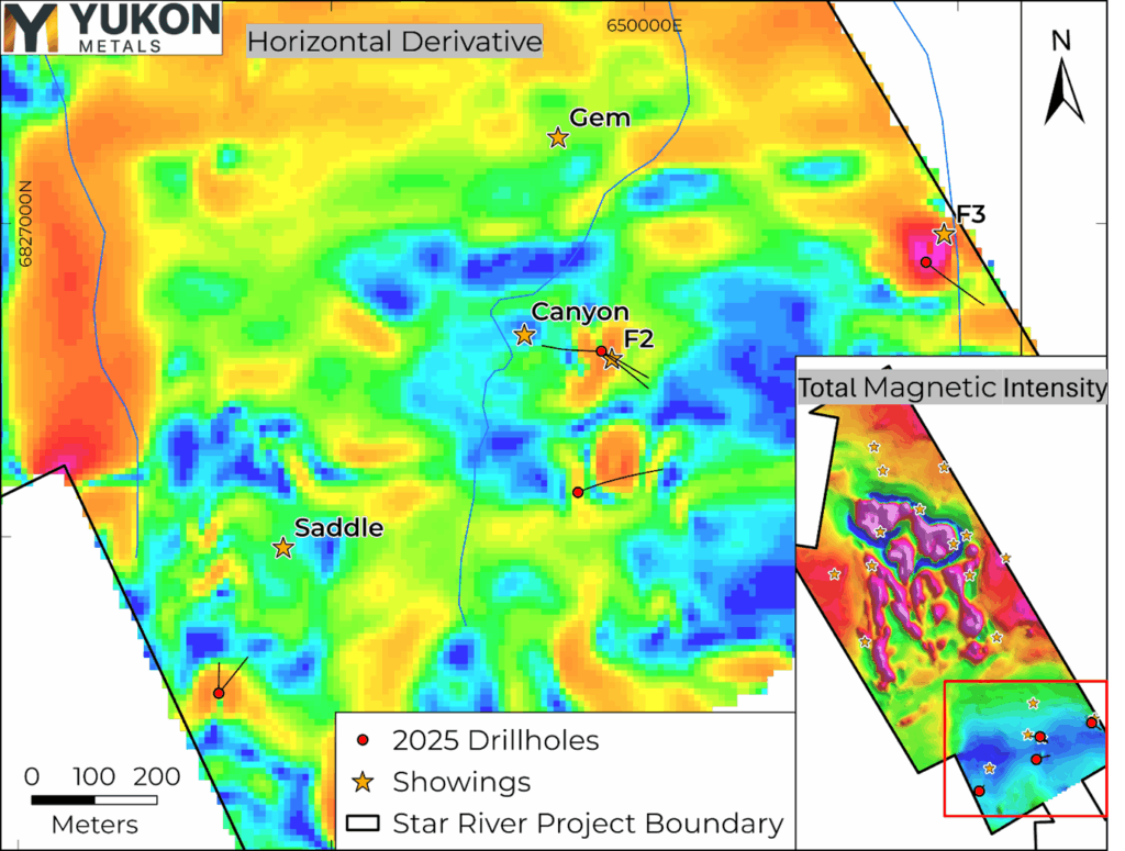
Figure 4- Total Magnetic Intensity and Horizontal Derivative products from the 2025 Drone Magnetics Survey. Red dots with extension lines show direction of drilling.
Table 2- Location of 2025 Star River Drillholes
| Hole ID | UTM_East | UTM_North | Elevation (m) | Azimuth | Dip | Length (m) | Location | ||||||||
| SR25-001 | 6826796 | 649931 | 1447 | 130 | -50 | 149 | near F2 vein | ||||||||
| SR25-002 | 6826796 | 649931 | 1447 | 120< /td> | -70 | 252 | near F2 vein | ||||||||
| SR25-003 | 6826796 | 649931 | 1447 | 270 | -70 | 300 | near F2 vein | ||||||||
| SR25-004* | 6826250 | 649320 | 1534 | 40 | -45 | 107 | near Saddle showing | & nbsp; | |||||||
| SR25-005* | 6826250 | 649320 | 1534 | 0 | -50 | 75 | near Saddle showing | ||||||||
| SR25-006 | 6826571 | 649894 | 1367 | 70 | -60 | 330 | South of F2 manto | ||||||||
| SR25-007 | 6826938 | 650449 | 1363 | 150 | -90 | 141 | near F3 vein | ||||||||
| SR25-008 | 6826938 | 650449 | 1363 | 130 | -60 | 237 | near F3 vein | ||||||||
*Holes SR25-004 and 005 exhibited poor recovery in a faulted oxide zone.
QA/QC
All diamond drill core from the 2025 drill program at Star River was logged, photographed, and sawed in half using a diamond blade core saw. One half of the core was submitted for geochemical analysis, while the other half was retained in secure storage for reference. Sampling intervals were determined based on geological boundaries and typically ranged from 0.3-1.5 meters. Control samples comprised approximately 10% of all samples submitted, including certified reference standards, analytical blanks, field duplicates, and preparation duplicates. QA/QC results were reviewed in real time, and all data have been verified as meeting acceptable thresholds for accuracy, precision, and contamination before inclusion in this news release.
Drill core and rock samples were sent to MSA for analysis with sample preparation in Terrace, BC and analysis in Langley, British Columbia. Samples were prepared by crush to 70% passing 2mm, 250g split pulverised better than 85% passing 75 microns (PRP-910). Pulp samples were analysed for 34 elements by four acid digestion and ICP-ES (ICP-230). All samples were analyzed for gold by fire assay and AA finish with a 50g nominal sample weight (FAS-121). Samples over 10 g/t Au were assayed by 50g fusion fire assay and gravimetric finish (FAS- 425). Samples over 100ppm silver were assayed with ICF-6Ag.
About the Star River Property
The Star River Property is in the Ketza district of southern Yukon, approximately 5 kilometres from the past-producing Ketza River Gold Mine. The Property hosts multiple polymetallic vein systems within metasedimentary rocks of the Cassiar Platform and lies within a district known for both gold and high-grade silver-lead mineralization.
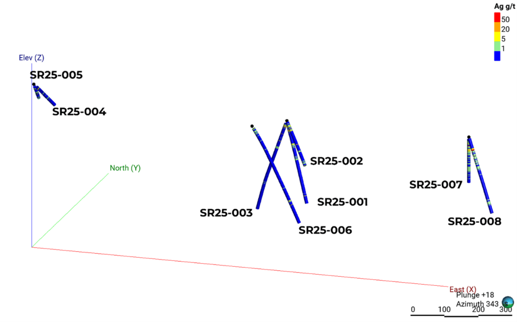
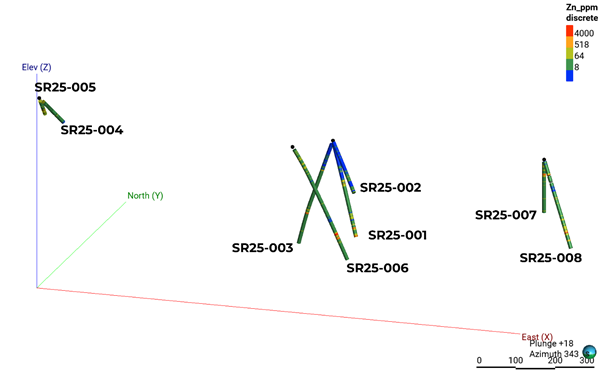
Figure 5 – 3D visualization of drill holes showing silver and zinc intercepts.
Qualified Person
The technical content of this news release has been reviewed and approved by Helena Kuikka, P.Geo., VP Exploration for Yukon Metals and a Qualified Person (as defined by National Instrument 43-101 – Standards of Disclosure for Mineral Projects).
About Yukon Metals Corp.
Yukon Metals is well financed and represents a property portfolio built on over 30 years of prospecting by the Berdahl family, the prospecting team behind Snowline Gold Corp.’s portfolio of primary gold assets. The Yukon Metals portfolio consis ts primarily of copper-gold and silver-lead-zinc assets, with a substantial gold and silver component. The Company is led by an experienced Board of Directors and Management Team across technical and finance disciplines.
Yukon Metals is focused on fostering sustainable growth and prosperity within Yukon’s local communities, while simultaneously enhancing stakeholder value. The Company’s strategy centers around inclusivity and shared prosperity, offering both community members and investors the chance to contribute to, and benefit from, its ventures.
The Yukon
The Yukon ranks 10th most prospective for mineral potential across global jurisdictions according to the Fraser Institute’s 2023 Survey of Mining Companies and is host to a highly experienced and conscientious local workforce, fostered by a long culture of exploration coupled with deep respect for the land. Recent major disco veries with local roots such as Snowline Gold Corp.’s Rogue Project – Valley Discovery, demonstrate the Yukon’s potential to generate fresh district-scale mining opportunities.
Manitoba-focused company, backed by the Canada Growth Fund, Orion... READ MORE
Golconda Gold Ltd. (TSX-V: GG) (OTCQX: GGGOF) is pleased to annou... READ MORE
Talamore Mining Corp. (TSX: TALA) (OTCQB: TALMF) is pleased to an... READ MORE
Atico Mining Corporation (TSX-V: ATY) (OTC: ATCMF) reports that i... READ MORE
ATERRA Metals Inc. (CSE: ATC) (OTCQB: CSSCF) is pleased to announ... READ MORE


