The Prospector News

XIMEN MINING AIRBORNE LiDAR SURVEY SURROUNDING KENVILLE GOLD MINE NELSON BC

You have opened a direct link to the current edition PDF

Open PDF Close
Uncategorized

Share this news article

XIMEN MINING AIRBORNE LiDAR SURVEY SURROUNDING KENVILLE GOLD MINE NELSON BC


Ximen Mining Corp. (TSX-V: XIM) (FRA: 1XMA) (OTCQB: XXMMF) announces that it has conducted an interpretation of the results from a LiDAR survey completed over a portion of its Nelson Property holdings in southern B.C., which surround the company’s flagship, the Kenville Gold Mine.

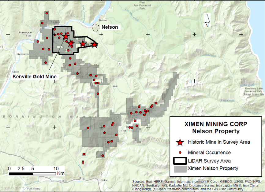
Figure 1. Ximen’s Nelson Property
showing survey area

Ximen is exploring an extensive land package of 21,497 hectares in the Nelson area that surrounds its Kenville Gold Mine project. A helicopter-borne LiDAR survey covering 36.1 square kilometers was completed over the Kenville and surrounding area (Figure 1 above).

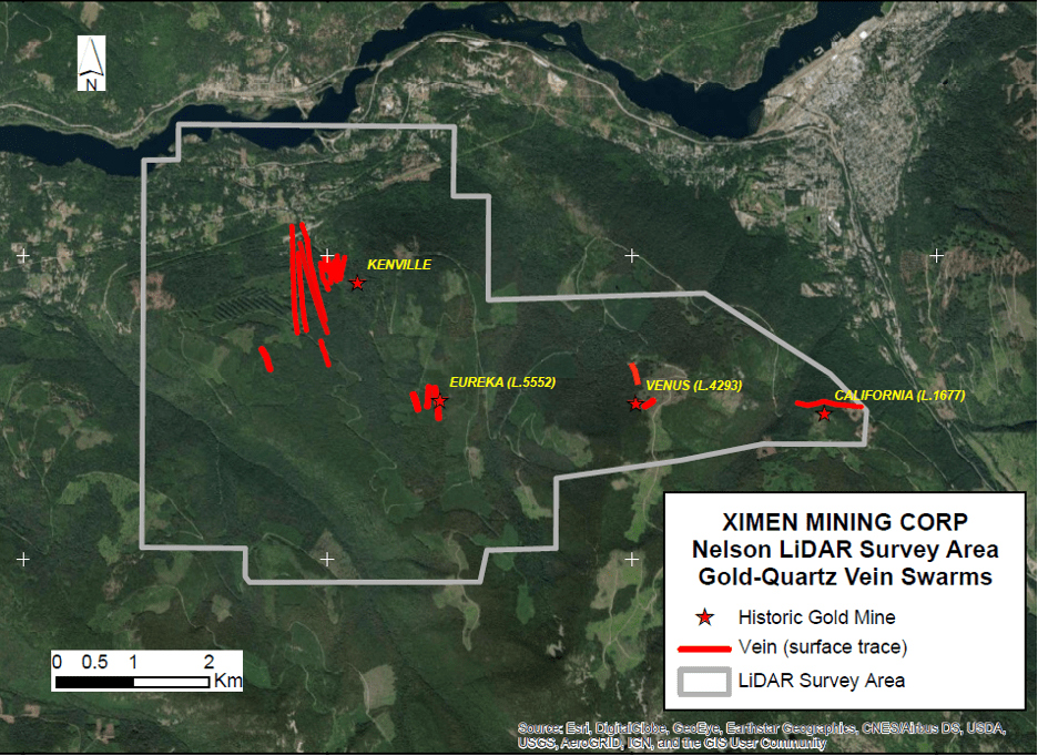
At Kenville, underground development was recently permitted to access new veins discovered by surface drilling.  Over its 64-year history of production, the Kenville mine produced 65,381 ounces of gold and 27,685 ounces of silver from 181,375 tonnes mined (BC Minfile). The Kenville deposit occurs within area of gold-quartz vein swarms measuring 8 by 3 kilometers that includes the Eureka, Venus and California historic mines (Figure 2). Total production from Eureka, Venus and California mines was 5,945 ounces gold and 43,547 ounces silver as well as significant copper, lead and zinc (BC Minfile).

The LiDAR survey resulted in two products: a digital elevation model (DEM) and orthophoto mosaic. The DEM was used to identify lineaments related to geological and geomorphological features. Lineaments were interpreted as faults, bedding traces and landscape-scale glacial grooves.   Features reflecting infrastructure such as logging roads and previous exploration workings were also identified, using a combination of the DEM (Figure 3) and the orthomosaic (Figure 4).

Figure 2. Map of known vein swarms extending over 8 x 3 km area
within LiDAR survey area

Figure 3. Lineaments identified
from LiDAR DEM

Figure 4. Orthomosaic from the LiDAR survey showing lineaments identified

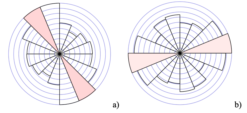
The lineaments fall into two statistical groups as shown by the Rose diagrams in Figure 4.  The length-weighted Rose diagram (a) shows a dominant north-northwest trend, representing the major valleys in the area including Eagle and 49er Creek.  These valleys are related to major faults including the Mt. Verde Fault and the Silver King Shear Zone, which is associated with gold mineralization in the area.  There are also numerous parallel lineaments in this group, some of which appear to be large-scale ridge–groove features in the bedrock interpreted as glacial in origin.  The non-length weighted Rose diagram shows a dominant east-northeast trend.  This group may represent cross-faults or quartz veins. Lineaments that parallel the known vein swarms are high priority and warrant follow-up exploration.

Figure 4.  Rose diagrams of lineaments showing length-weighted (a)
and non length-weighted groupings (b)

Readers are cautioned that historical records referred to in this News Release have been examined but not verified by a Qualified Person. Further work is required to verify that historical records referred to in this News Release are accurate.

Dr. Mathew Ball, P.Geo., VP Exploration for Ximen Mining Corp. and a Qualified Person as defined by NI 43-101, approved the technical information contained in this News Release.

Posted October 19, 2023

Share this news article

MORE or "UNCATEGORIZED"


Fredonia Announces Closing of C$11.5M Bought Deal Private Placement Including Full Exercise of Underwriters’ Option

Fredonia Mining Inc. (TSX-V: FRED) is pleased to announce that it has closed its previously announce... READ MORE

September 23, 2026

SAGA Metals Drills 485.4 m at 32.21% Fe2O3, 5.30% TiO2, 0.191% V2O5 Including 56.8 m at 49.56% Fe2O3, 8.17% TiO2, 0.339% V2O5 at Radar Critical Minerals Project in Labrador

SAGA Metals Corp. (TSX-V: SAGA) (OTCQX: SAGMF) (FSE: 20H), a North American exploration company foc... READ MORE

September 23, 2026

Legacy in New Core Hole Hits 3.7 g/t Gold over 41ft (12.5m) near Surface, Incl. 15.1 g/t over 6.7ft (2.05m), plus 4 Mineralized Zones Incl. 0.62 g/t over 127ft (38.8m) at Baner, Idaho

Legacy Gold Mines Ltd. (TSX-V: LEGY) is pleased to report assay results from core holes LG26-017 an... READ MORE

September 23, 2026

Inventus Expands Shallow High-Grade Main Layer and Identifies Broad Bulk-Tonnage Gold Potential at Pardo

Inventus Mining Corp. (TSX-V: IVS) is pleased to report results from 100 drill holes from its now-... READ MORE

September 23, 2026

Sleeping Giant Mine Activity Report

Abcourt Mines Inc. (TSX-V: ABI) (OTCQB: ABMBF) is pleased to present its operational report for the ... READ MORE

September 23, 2026

Copyright 2026 The Prospector News