


Whitehorse Gold Corp. (TSX-V: WHG) reports additional results from the 2020 drill program at its Skukum Gold Project located in the Whitehorse Mining District, southern Yukon.
Drill hole SC20-002 intersected 10.5 metres (6.3 metres true width) grading 8.1 g/t Au and 175 g/t Ag, including 2.2 metres of 25.2 g/t Au and 636 g/t Ag, in the Rainbow Zone of the Skukum Creek deposit (Table 1 and Figure 1). Results from the remaining two 2020 drillholes are pending.
Table 1: Assay results for SC20-001 and SC20-002
| Hole ID | From (m) | To (m) | Interval (m)1 | Au (g/t) | Ag (g/t) | Pb (%) | Zn (%) | True Width (m) | Zone | |
| SC20-001 (previously released) |
434.08 | 443.01 | 8.93 | 6.54 | 186.83 | 1.40 | 0.99 | 8.07 | Rainbow Zone | |
| Incl. | 437.60 | 439.76 | 2.16 | 7.80 | 306.05 | 1.79 | 0.96 | 1.94 | ||
| Incl. | 441.79 | 443.01 | 1.22 | 21.40 | 563.00 | 5.27 | 3.59 | 1.10 | ||
| SC20-002 | 417.45 | 427.94 | 10.49 | 8.13 | 175.11 | 0.84 | 1.02 | 6.31 | ||
| Incl. | 417.45 | 419.39 | 2.24 | 25.24 | 636.47 | 2.53 | 3.19 | 1.35 | ||
| Incl. | 426.37 | 427.94 | 1.57 | 13.30 | 152.00 | 1.23 | 0.92 | 0.94 |
Notes:
The 2020 drill program consisted of 4 drillholes designed to better define the deeper portion of the Skukum Creek deposit, validate historic drill hole intercepts, and to test re-interpreted, potentially thicker, and higher-grade portions of the deposit which remain open for expansion.
Kevin Weston, CEO of Whitehorse Gold stated, “The results from our 2020 exploration continue to verify both the depth potential and the high-grade tenor of the Skukum Creek gold deposit. We are encouraged by the zone thickness and look forward to releasing the additional drill results as we are finalizing our 2021 drill campaign which is aimed at increasing the mineral resources at the Project.”
2020 Exploration Program – Skukum Creek Deposit
The Company’s inaugural exploration program was primarily focused on gaining geologic understanding of the numerous exploration targets, completing historic data validation and collecting new data in support of a resource expansion program planned for 2021. In detail the 2020 exploration program consisted of reconnaissance mapping, data compilation, re-interpretation of the Skukum Gold system and a 4-hole, 2,091-metre diamond drilling program on the Skukum Creek deposit (Figures 1 and 2).
Skukum Creek is the largest of the Project’s three deposits currently defined with over 1 million indicated tonnes grading 5.85 g/t Au and 166.4 g/t Ag and 537,000 inferred tonnes grading 4.99 g/t Au and 108.3 g/t Ag (Table 2).
Hole SC20-002 intersected mineralization in the Rainbow Zone at approximately 417 metres downhole and returned 10.5 metres (6.3 metres true width) grading 8.1 g/t Au and 175 g/t Ag, including 2.4 metres of 25.2 g/t Au and 636 g/t Ag (Table 1 and Figures 2 and 3). This mineralized interval is comparable to the nearby historic drill hole SC11-01, which returned 8.42 g/t Au and 82.63 g/t Ag over a true width of 5.82 metres (Table 3 and Figures 2 and 3).
As detailed in the Company’s Technical Report (as defined below), the three delineated deposits on the Project (Skukum Creek, Goddell and Mt. Skukum) individually host the following mineral resources using a 3.0 g/t gold equivalent (AuEQ) cut-off grade.
Table 2: 2020 resource estimates for deposits on the Property using a 3.0 g/t AuEQ cut-off grade.
| Class | Tonnes | Au (g/t) | Ag (g/t) | AuEQ (g/t) | Contained oz Au | Contained oz Ag | Contained oz AuEQ | |
| Skukum Creek | Indicated | 1,001,300 | 5.85 | 166.4 | 7.75 | 188,334 | 5,355,478 | 249,401 |
| Inferred | 537,000 | 4.99 | 108.3 | 6.22 | 86,124 | 1,869,065 | 107,415 | |
| Goddell | Indicated | 329,700 | 8.13 | – | 8.13 | 86,210 | – | 86,210 |
| Inferred | 483,900 | 7.13 | – | 7.13 | 110,867 | – | 110,867 | |
| Mt Skukum | Inferred | 90,100 | 9.28 | 12.9 | 9.43 | 26,882 | 37,368 | 27,308 |
Notes:
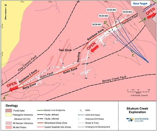
Figure 1: Bedrock geologic map of the Skukum Creek deposit showing traces of 2020 drill program.

Figure 2: Long section looking WNW, showing mineralized zones, underground workings, historic drilling, 2020 drill holes (blue) and location of Cross Section (Figure 3).
Table 3: Assay composites for historic drill holes presented in Figure 3.
| Hole ID | From (m) | To (m) | Interval (m)1 |
Au (g/t) | Ag (g/t) | True Width (m) | Zone |
| R96-211 | 56.00 | 66.30 | 10.30 | 17.66 | 170.67 | 7.56 | Rainbow Zone |
| R96-212 | 75.90 | 78.90 | 3.00 | 1.54 | 39.10 | 2.10 | |
| R96-213 | 128.80 | 154.15 | 25.35 | 23.08 | 259.03 | 7.16 | |
| SC02-18 | 118.50 | 124.94 | 6.44 | 6.11 | 122.85 | 3.91 | |
| SC11-01 | 368.30 | 380.40 | 12.10 | 8.42 | 82.63 | 5.82 |
Notes:

Figure 3: 3a) Cross section through the Rainbow Zone showing gold grades for SC20-002 and historic drill holes. 3b)same as 3a but showing silver grades. Section is approximately 25 metres thick looking WSW (227°).
Table 4: Drill hole details for current and historic drill holes presented in this document.
| Hole ID | Northing | Easting | Elevation | Total Depth | Collar Azimuth | Collar Dip | Year | Type | Operator |
| Whitehorse Gold Drill Holes | |||||||||
| SC20-001 | 478101.1 | 6671141.2 | 1390.9 | 490.42 | 304.9 | 48.1 | 2020 | SFC | WHG |
| SC20-002 | 478101.8 | 6671140.7 | 1390.9 | 480.67 | 307.3 | 46.0 | 2020 | SFC | WHG |
| Historic Drill Holes | |||||||||
| R96-213 | 477890.6 | 6671322.3 | 1221.0 | 164.29 | 325.0 | 82.0 | 1996 | UG | Omni1 |
| SC02-18 | 477891.2 | 6671321.2 | 1222.2 | 146.91 | 317.5 | 77.4 | 2002 | UG | TLG2 |
| SC11-01 | 477945.5 | 6671171.4 | 1444.6 | 412.83 | 327.0 | 63.5 | 2011 | SFC | NUAG3 |
| R96-212 | 477890.6 | 6671322.3 | 1221.0 | 100.28 | 325.0 | 69.0 | 1996 | UG | Omni1 |
| R96-211 | 477890.6 | 6671322.3 | 1222.0 | 72.85 | 325.0 | 55.0 | 1996 | UG | Omni1 |
Notes:
Qualified Persons
The independent Qualified Person for the mineral resource estimate is Ronald G. Simpson, P.Geo. from GeoSim Services, Inc. The technical information contained in this news release has been reviewed and approved by Tim Kingsley, Vice President of Exploration of Whitehorse Gold and Certified Professional Geologist (CPG-11538) with the American Institute of Professional Geologists, a Qualified Person for the purposes of National Instrument 43-101 – Standards of Disclosure of Mineral Projects.
Quality Assurance and Quality Control
Drill core from the Company’s 2020 exploration program was logged and sampled in a secure core storage facility located at the Project site. Core samples from the program were cut in half, using a diamond cutting saw. Drill core and surface samples were sent to ALS Laboratories, which is independent of the Company. Sample preparation was performed at the ALS Laboratory in Whitehorse, YT, followed by analysis at the ALS Laboratory in North Vancouver, ALS is an accredited mineral analysis laboratory. All samples were analysed for gold using standard Fire Assay-AA techniques. Samples returning over 10.0 g/t gold were analysed utilizing standard Fire Assay-Gravimetric methods. Samples were also analyzed for a 48 multi-element geochemical suite by ICP-MS with a four-acid digestion. Certified gold reference standards, blanks, field duplicates and coarse reject duplicates were routinely inserted into the sample stream, as part of Whitehorse Gold’s quality control/quality assurance program.
Historic QA/QC data and methodology were reviewed and are summarized in the Technical Report. The author of the Technical Report considered historical sample preparation, analysis, and security to have been generally performed in accordance with exploration best practices at the time of collection.
ABOUT WHITEHORSE GOLD CORP.
Whitehorse Gold is focused on its wholly-owned Skukum Gold Project (formerly named the Tagish Lake Gold Project) located in the Whitehorse Mining District of the southern Yukon. The Project consists of 1,051 mineral claims covering an area of 170 square kilometres and is located approximately 55 kilometres south of Whitehorse, Yukon, in the Wheaton River Valley region. The Project hosts the advanced-stage Skukum Creek, Goddell and Mount Skukum high-grade gold deposits and multiple high-priority exploration targets. The Project infrastructure includes an all-weather access road, an all-weather 50-person camp, approximately 4.8 kilometres of underground workings, an extensive surface road network and a previously operating 300-tpd mill along with a tailings management facility and service buildings. Over 140,000 metres of drilling was completed on the Project by former operators. Historical underground operations on the Mount Skukum deposit from 1986 to 1988 saw a total of 233,400 tons of ore mined and processed in the plant, recovering approximately 79,750 ounces of gold under a previous operator.
Targa Exploration Corp. (CSE: TEX) (FRA: V6Y) (OTCQB: TRGEF) an... READ MORE
SIRIOS RESOURCES INC. (TSX-V: SOI) announces that it has closed,... READ MORE
Adventus Mining Corporation (TSX-V: ADZN) and Silvercorp Metals... READ MORE
i-80 Gold Corp. (TSX: IAU) (NYSE American: IAUX) is pleased to ... READ MORE
retains a 1.5% gold net smelter return royalty for the La Arena I... READ MORE


