








West Point Gold Corp. (TSX-V: WPG) (OTCQX: WPGCF) (FSE: LRA0) is pleased to announce the results from two drill holes within the high-grade Northeast Tyro zone at its flagship Gold Chain Project in Arizona. Hole GC26-168 was a reverse circulation hole that intersected 56.4 metres of 4.24 grams per tonne gold from 242.3m, including 28.9m at 7.77 g/t. This hole was drilled as a follow-up to GC26-161, which was a core hole that intersected 68.2m at 2.20 g/t Au from 210.5m, including 34.3m at 3.57 g/t Au. These holes continue to extend the zone at NE Tyro down-dip where it remains open to depth. The previously released hole GC26-148 (see release here) suggests that the zone appears to be widening at depth.
The Company is reporting assay results for two drill holes (628.5m), GC26-161 and GC26-168. Results from 19 holes representing 5,920m of the recently completed 21,079m program are still pending. All results from Tyro Main and NE Tyro are expected to contribute to the Company’s upcoming maiden resource estimate to be released later in 2026.
Highlights:
“With these results and GC26-148, the apparent widening, along with the textures observed, suggests multiple gold mineralizing events with deposition over a greater vertical range than you would typically see in low sulphidation epithermal systems. These results further support the zone remaining open to depth,” stated Derek Macpherson, President and CEO.
Table 1: Drill Results
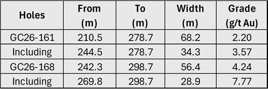
Note: All widths shown are downhole; true widths are approximately 50-60% of downhole widths.
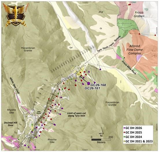
Figure 1. Plan view of the Main Tyro vein showing geology and drilling conducted in 2021, 2023, 2024, 2025, and 2026. Note the location of Hole Nos. GC26-161 and GC26-168.
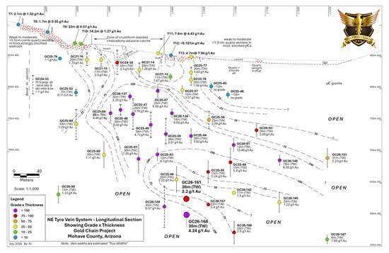
Figure 2. Longitudinal perspective of the Tyro NE zone contoured GT (g/t Au X estimated true thickness). Both Holes GC26-161 and -168 are contained within the GT >100 interval.
GC26-161 and -168
Both Holes GC26-161 (core) and -168 (RC) targeted the down-dip extension of the NE Tyro zone and crossed the vein system between holes GC26-148 (66.2m at 6.57 g/t Au) and GC26-157 (31m at 3.4 g/t Au) at an elevation of about 600m above sea level (“ASL”) which is 250m below surface (Figure 2). Both holes deviated somewhat to the south resulting in a step-out of only about 30 metres from GC26-148. The proximity of the two holes allows for a comparison between the two drilling/sampling techniques. It was also deemed important to cross higher-grade portions with core where detailed documentation of recovery, RQD, vein styles, textures and density has occurred. In summary, these two holes support the emerging geologic (Figure 3) and grade models (Figure 2) and improve the definition of the high-grade gold mineralization in the NE Tyro zone at the Company’s Gold Chain project in Arizona. The two holes comprising this release represent 628.5m of the now completed 21,079m drill program.
Both holes, shown in Figures 2 and 3, corroborate the widening of the vein system observed to the south in hole GC26-148 (see release here). The primary structural control appears to define the footwall (FW) contact where a broad, and generally high-grade, hydrothermal breccia is in sharp contact with the hosting Precambrian granite. The intensity of vein-filling (quartz-calcite-adularia) diminishes upwards toward the hanging wall (HW) along with a general decrease in gold grades. Figure 3 also suggests that the vein system may be steeping at an elevation of about 650m ASL (200m below surface), which may explain the widening of the ‘damage zone’ and associated fracturing.
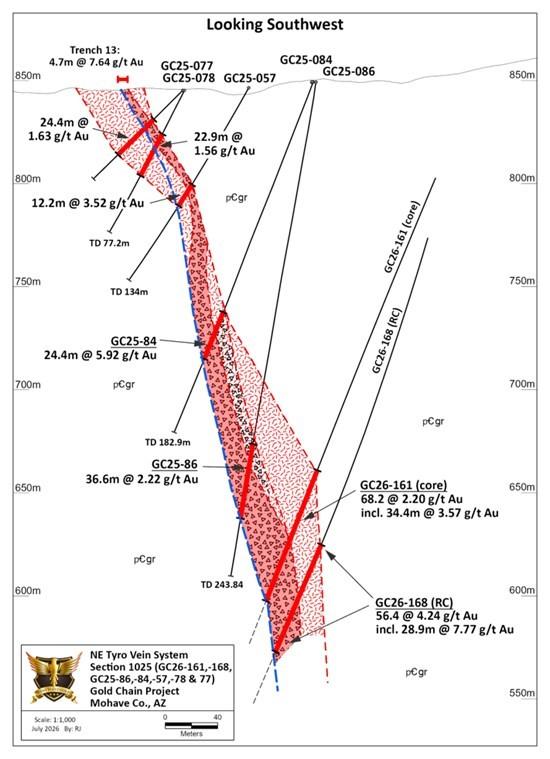
Figure 3. Geologic section drawn along GC26-161 and GC26-168 showing vein and spatial relation to GC25-77, GC25-78, GC25-57, GC25-084, and Trench 13 on the surface.
Hole GC26-161 encountered mineralization between 201.5 and 278.7m containing 2.20 g/t Au within a broad envelope of fractured, broken and altered granite. This envelope contains 34.3m at 3.57 g/t Au from 244.5m in a zone of quartz-chalcedony-calcite adularia stockwork and breccia (Figure 4). Hole GC26-168 encountered similar mineralization at a slightly greater depth (Figure 3) from 242.3 to 298.7m (56.4m) at 4.24 g/t Au, containing 28.9m at 7.77 g/t Au from 269.8m down to the FW contact (Figure 3).
The vein system along this section (Figure 3) dips 75 degrees where it steepens to near-vertical at about 650m ASL (200m below surface). The intercept has developed around a couple of fine-grained intrusive phases, i.e. dikes, that are strongly altered, broken and veined. This spatial coincidence may reflect a preference for the gold-bearing fluids to follow the dikes (more brittle) and/or the contact with the hosting Precambrian (likely broken and faulted). The modelling of these features in the upcoming weeks will provide greater insight into deeper targets.
Figure 4 provides a photo of the main mineralized zone or ‘vein breccia’ in GC26-161, which hosts most of the gold mineralization. Veins and breccia composing the NE Tyro vein are multi-stage and comprised of quartz-chalcedony-calcite (bladed)-adularia with only trace amounts of pyrite. Bladed calcite or “lattice texture” has developed in several stages and ranges from delicate bands within crustiform/coliform-banded chalcedony to coarse, angular fragments in late-stage breccia.
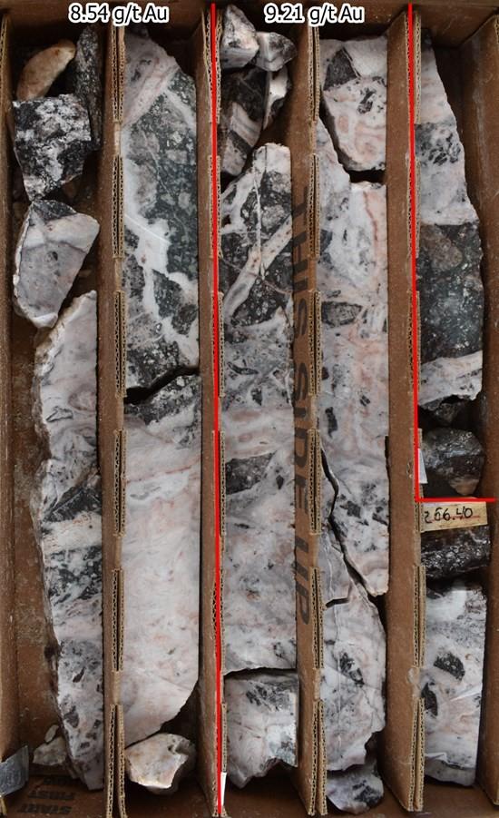
Figure 4. Photo GC26-161 showing a portion of the vein and corresponding gold values. Core reveals that the NE Tyro vein is a broad zone of multi-stage veins and breccia hosting a broad array of textures.
Table 2: Drill hole locations and descriptions

Qualified Person
Robert Johansing, M.Sc. Econ. Geol., P. Geo., the Company’s Vice President, Exploration, is a qualified person as defined by NI 43-101 and has reviewed and approved the technical content of this press release. Mr. Johansing has also been responsible for overseeing all phases of the drilling program, including logging, cutting, labelling, bagging and transport from the project to American Assay Laboratories (AAL) of Sparks, Nevada. Reverse Circulation (RC) drill holes have a diameter of about 10cm (~4″), and samples have an approximate weight of 5 to 10kg. Core size is HQ (2.5″/63.5mm) and is logged, photographed and cut at the Company’s Bullhead City sampling facility including the insertion of blanks and standards. All samples are packaged for shipment at the facility and trucked to AAL in Reno. Samples were then dried, crushed and split, and pulp samples were prepared for analysis. Gold was determined by fire assay with an ICP finish, and over-limit samples were determined by fire assay and gravimetric finish. Silver plus 15 other elements were determined by Aqua Regia ICP-AES (IM-2A16), and over-limit samples were determined by fire assay and gravimetric finish. Both certified standards and blanks were inserted on site along with duplicates, standards and blanks inserted by American Assay. The results summarized above have been carefully reviewed with reference to the QA/QC results. Standard sample chain of custody procedures were employed during drilling and sampling campaigns until delivery to the analytical facility.
About West Point Gold Corp.
West Point Gold is an exploration and development company focused on unlocking value across four strategically located projects along the prolific Walker Lane Trend in Nevada and Arizona, USA, providing shareholders with exposure to multiple discovery opportunities across one of North America’s most productive gold regions. The Company’s near-term priority is advancing its flagship Gold Chain Project in Arizona.
Brutus Mining Inc. (CSE: BRU) (FSE: ZI3) is pleased to announce that it has closed its non-brokered ... READ MORE
Jaguar Uranium Corp. (NYSE American: JAGU) is pleased to announce an independent Mineral Resource E... READ MORE
Auro Metals Inc. (TSX-V: AURO) (OTCQB: AURFF), is pleased to announce the assay results of the fina... READ MORE
Endeavour Silver Corp. (NYSE: EXK) (TSX: EDR) is pleased to announce that repairs to the primary bal... READ MORE
Scorpio Gold Corp. (NASDAQ: SGLD) (TSX-V: SGLD) (OTCQB: SRCRF) (FSE: RY9) is pleased to announce re... READ MORE


