


West Point Gold Corp. (TSX-V: WPG) (OTCQB: WPGCF) (FSE: LRA0) is pleased to announce the most recent drill results from its recently completed reverse circulation drill program at the Tyro Main Zone, Gold Chain Project, Arizona. This release contains the assays for drill holes GC25-57 and GC25-58, totalling 301.7 metres (“m”).
Highlights:
“These results expand the width of the recently defined high-grade zone at northeast Tyro to 190 metres, and the overall Tyro Main Zone remains open, north towards the Frisco Graben. Significantly, grades at northeast Tyro appear to be improving at depth”, stated CEO Quentin Mai. “In the next drill campaign, we plan to focus on the northeast Tyro segment where high-grade gold mineralization remains open to the northeast and at depth.”
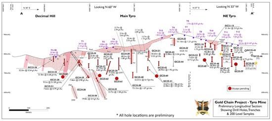
Figure 1: Long Section of the Tyro Main Zone
Notes:
Table 1: Drill Results
| Holes | From (m) | To (m) | Width (m) | Grade (g/t Au) | |
| GC25-57 | 53.30 | 67.10 | 13.80 | 3.16 | |
| incl. | 56.40 | 64.00 | 7.60 | 4.31 | |
| and | 99.10 | 100.60 | 1.50 | 4.57 | |
| GC-25-58 | 91.40 | 123.40 | 32.00 | 2.01 | |
| incl. | 121.90 | 123.40 | 1.50 | 26.70 |
Notes:
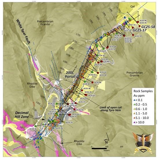
Figure 2: Plan View of Tyro Main Zone Showing Drill Holes, Trenches and Surface Samples (gold). Note that the distance along the Tyro’s strike between GC25-48 (L915) and GC25-58 (L1070) is about 190 metres.
Summary
Recent drilling across the NE Tyro veins (core and RC) has identified that high-grade veins observed at the surface coalesce downward into a broad, high-grade zone. The high-grade component here is characterized by banded chalcedony-adularia-calcite vein and stockwork hosted by strongly altered (quartz + chlorite) wall rock, i.e. GC25-47 with 50.3m of 3.76 g/t Au. Holes GC25-57 and GC25-58 were designed to define the limits of this zone along with the plunge of the emerging shoot. The current drill sections suggest a moderate to steep northeast plunge toward the Frisco Graben. Upon receipt of assays for a few additional holes, sufficient data will be available to design the follow-up drill program.
The addition of holes GC25-57 and GC25-58, as described below, expands the higher-grade zone defined in holes GC25-47 to GC25-49 to the north by approximately 90 metres of strike length and demonstrates that the Tyro Main zone overall appears to extend to the northeast towards the Frisco Graben despite there being a lack of visible surface exposures.
Hole GC25-57
Hole GC25-57 was drilled to test the zone about 30m below hole GC21-13 (12.2m of 1.67 g/t Au) or about 60m below weakly developed surface vein exposures (Figure 3). A broad package of quartz veining was observed between 45 and 105m, which contained 13.8m of 3.16 g/t Au (53.3 to 67.1m) near the zone’s hanging wall and 1.5m of 4.57 g/t Au (99.1 to 100.6m) at the footwall contact. This intercept is positioned about 50m north and 50m up-dip from the intercept observed in GC25-49. Logging suggests that the two holes traversed a similar structural setting.
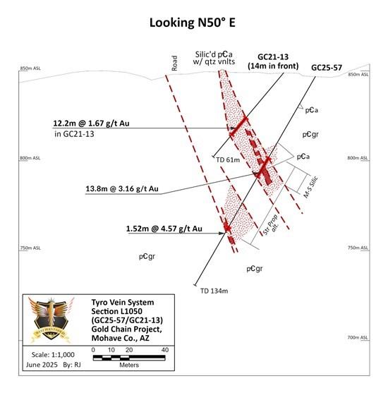
Figure 3: Hole GC25-57 Cross Section
Hole GC25-58
This hole was drilled about 90 metres north of GC25-49 and 60 metres beneath GC25-45. Both holes GC25-45 and GC25-46 intersected broad intervals of strong quartz-chlorite alteration with only locally weak quartz veining hosting trace gold values. Hole GC25-58 intersected a broad zone of quartz-adularia-calcite veins and veinlets from 91.4 to 123.4m (32.0m) of 2.01 g/t Au. This intercept indicates that the Main Tyro zone continues to the northeast despite there being no surface exposure. Perhaps most importantly, this intercept continues to locate strong gold mineralization to the northeast and closer to the intersection with the Frisco Mine fault, about 400m to the northeast.
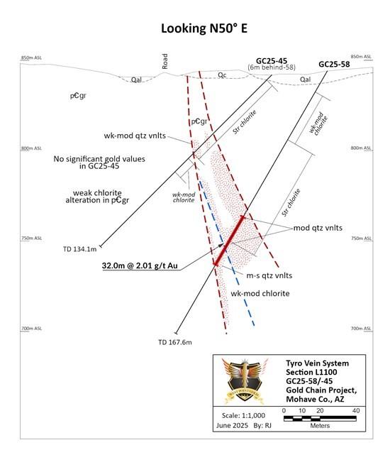
Figure 4: Hole GC25-58 Cross Section
Qualified Person
Robert Johansing, M.Sc. Econ. Geol., P. Geo., the Company’s Vice President, Exploration, is a qualified person (“QP”) as defined by NI 43-101 and has reviewed and approved the technical content of this press release. Mr. Johansing has also been responsible for overseeing all phases of the drilling program, including logging, labelling, bagging and transport from the project to American Assay Laboratories of Sparks, Nevada. Drillholes have a diameter of 15cm, and samples have an approximate weight of 3 to 5kg. Samples were then dried, crushed and split, and pulp samples were prepared for analysis. Gold was determined by fire assay with an ICP finish, and over-limit samples were determined by fire assay and gravimetric finish. Silver plus 15 other elements were determined by Aqua Regia ICP-AES (IM-2A16), and over-limit samples were determined by fire assay and gravimetric finish. Both certified standards and blanks were inserted on site along with duplicates, standards and blanks inserted by American Assay. The results summarized above have been carefully reviewed with reference to the QA/QC results. Standard sample chain of custody procedures were employed during drilling and sampling campaigns until delivery to the analytical facility.
About West Point Gold Corp.
West Point Gold Corp. (formerly Gold79 Mines Ltd.) is a publicly listed company focused on gold discovery and development at four prolific Walker Lane Trend projects covering Nevada and Arizona, USA. West Point Gold is focused on developing a maiden resource at its Gold Chain project in Arizona, while JV partner Kinross is advancing the Jefferson Canyon project in Nevada.
Imperial Metals Corporation (TSX:III) reports copper and gold p... READ MORE
Aldebaran Resources Inc. (TSX-V: ALDE) (OTCQX: ADBRF) and its maj... READ MORE
Nevada Sunrise Metals Corporation (TSX-V: NEV) (OTC Pink: NVSGF)... READ MORE
Newmont Corporation (NYSE: NEM) (ASX: NEM) (PNGX: NEM) announced ... READ MORE
Scorpio Gold Corporation (TSX-V: SGN) (OTCQB: SRCRF) (FSE: RY9) i... READ MORE


