


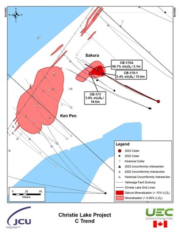
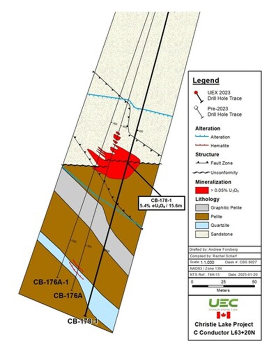
Uranium Energy Corp (NYSE American: UEC) is pleased to announce new uranium mineralization in drill hole CB-178-1 that grades 5.42% eU3O8 over 15.6 metres, including a subinterval that grades 23.2% eU3O8 over 3.4 metres (Table 1). This result expands the footprint of high-grade uranium mineralization at the Christie Lake Project that was initially announced last year (see press release from October 4, 2022).
Vertical depth to the unconformity-hosted mineralization at Christie Lake is between 400 and 420 metres from surface. This is shallower by about 100 m than McArthur River and at approximately the same depth as Cigar Lake. The McArthur River and Cigar Lake Deposits are the archetypical high-grade Athabasca super-deposits with combined reserves and past production of 985.7 million lb. uranium.
Amir Adnani, CEO and President stated: “Following our acquisition of UEX in 2022 we commenced a drilling program at the Christie Lake Project and reported one of the best intercepts of the year in Canada’s high-grade Athabasca Basin with our discovery at the Sakura zone, with 68.7% eU3O8 over 2.1 meters. We hit the ground running in 2023 to follow-up and test the continuity at this new zone and are excited to see the first drill hole of our new program expand the footprint of the high-grade mineralization. The results announced today also demonstrate the capability of our Canadian technical team to unlock value from UEC’s Canadian conventional project pipeline. Moving forward, we have two objectives with our Eastern Athabasca Basin projects, 1) continue with aggressive exploration drilling for resource growth and 2) evaluate potential synergies for future development given the proximity of Christie Lake and Horseshoe Raven projects to our recently acquired Roughrider project.”
Chris Hamel, Vice President Exploration, Canada stated: “The confirmed continuity of the high-grade uranium mineralization at the Sakura zone suggests a previously unrecognized trend of uranium mineralization at Christie Lake. With constrained expenditures during the years of the uranium bear market the exciting potential of Christie Lake was left under-explored. We’re excited to be aggressively drilling and growing the world-class potential of this project. UEC’s ability to apply financial strength into the project builds upon the technical work and compilation efforts done by UEX since 2016 to set the stage for this success.”
Mineralization at the Sakura Zone remains open for expansion in all directions and is the focus of the 2023 drilling on the Christie Lake Project.
Table 1: Christie Lake Radiometric Equivalent Grades from CB-178-1
From
(m)To
(m)Width
(m)Grade
(% eU3O8)Cut-off
Grade
(% eU3O8)
| Hole | |||||||
| CB-178-1 | 419.1 | 434.7 | 15.6 | 5.42 | 0.05 | ||
| incl. | 426.6 | 430.0 | 3.4 | 23.22 | 5.0 | ||
Notes:
| 1. | True widths of the mineralization reported in Table 1 is anticipated to be 90-95% of core length but cannot be verified at this time. |
| 2. | eU3O8 refers to radiometric equivalent grade U3O8, and it determined using calibrated down-hole radiometric probes, a process further discussed in the section “About Radiometric Grades”. |
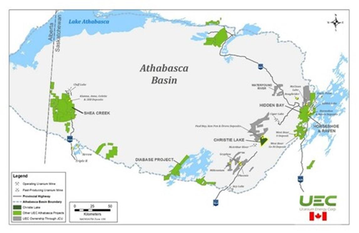
Figure 1 – UEC’s Athabasca Basin Projects
About Canada’s Athabasca Basin
The Athabasca Basin is a world-class uranium district in the northern portion of the provinces of Saskatchewan and Alberta in Canada, occupying an area of about 100,000 square kilometers. The unique geology of the Athabasca Basin deposits can result in deposit grades that exceed the world average of uranium deposits of 0.2% U3O8 by up to 100 times.
All of Canada’s current uranium production occurs from the mines located in the Athabasca Basin. According to the World Nuclear Association, the Athabasca Basin was responsible for producing 9.7% of the world’s uranium production in 2021.
Uranium mineralization in the Athabasca Basin occurs in fault structures that penetrate the interface between the sandstone and underlying basement rocks, known as the unconformity. Uranium can be found at the interface, known as the unconformity, or up to several hundreds of meters below the unconformity surface in the underlying fault structures in the basement.
The uranium concentrations from holes presented above from the radiometric equivalent uranium grade (“REG”), denoted as eU3O8, which is determined in-situ within the drill hole. For more information on REGs please see the “About Radiometric Equivalent Grades” section below.
The core recovery from parts of the mineralized zone in hole CB-178-1 is estimated at approximately 50%. The portions of the core recovered from the interval confirm the presence of very high-grade uranium mineralization. Thus, the Company believes that assay results collected from the mineralized interval may not be representative of the true concentration of uranium present and that the REG presented above will be a more accurate estimate of grade.
About Radiometric Equivalent Grades
The eU3O8 grades were estimated in-situ within the drill holes using calibrated down-hole radiometric gamma probes which are lowered down the hole, a method commonly used by uranium explorers and miners in the Athabasca Basin. The probe records the amount of radioactivity present in the rock adjacent to the probe as it moves up and down the hole.
The probes were calibrated prior to the commencement of the current drill program at the Saskatchewan Research Council’s (“SRC”) test pit facility in Saskatoon. Using down-hole probes to calculate radiometric equivalent grades is a common practice by uranium mining companies in the Athabasca Basin. Down-hole probes can accurately measure uranium concentration by measuring the light flashes that occur every time the probe’s scintillator is struck by a gamma radiation particle emitted from uranium crystals. The number of light flashes are ‘counted’ by a photomultiplier tube. Sometimes within high-grade intervals, due to a process called ‘saturation’ occurs when light emitted by the probe’s scintillator overwhelms the photomultiplier tube’s ability to ‘count’ individual light flashes it can be difficult to accurate determine radiometric equivalent grades.
Samples from all holes have been collected for assay analysis to confirm these equivalent grades. The samples will be analyzed at the SRC’s Geoanalytical Laboratory in Saskatoon, Saskatchewan, with results expected in the coming weeks.
About the Christie Lake Project
UEC holds an 82.775% combined direct and indirect interest in the Christie Lake Project which is a joint venture with JCU (Canada) Exploration Company, Limited, a company that is 50% owned by UEC’s wholly owned subsidiary UEX Corporation. UEC’s direct ownership in Christie Lake is 65.5492% and indirect ownership through its 50% ownership in JCU is 17.2254%
The Christie Lake Project is located in the eastern Athabasca Basin (see Figures 1 & 2) approximately 9 km northeast and along strike of Cameco’s McArthur River Mine, the world’s largest and highest-grade uranium mine. The controlling structure of the McArthur River Mine deposits, the P2 fault, continues to the northeast beyond the mine and trends onto the Christie Lake Project. Our technical team believes that, through a series of en-echelon steps, the northeast strike extension of the P2 Fault not only crosses the Christie Lake Project but also controls the three known uranium deposits on Christie Lake: the Ōrora, Paul Bay and Ken Pen Deposits as well as the newly discovered Sakura Zone.
Figure 2 – Christie Lake Project Location
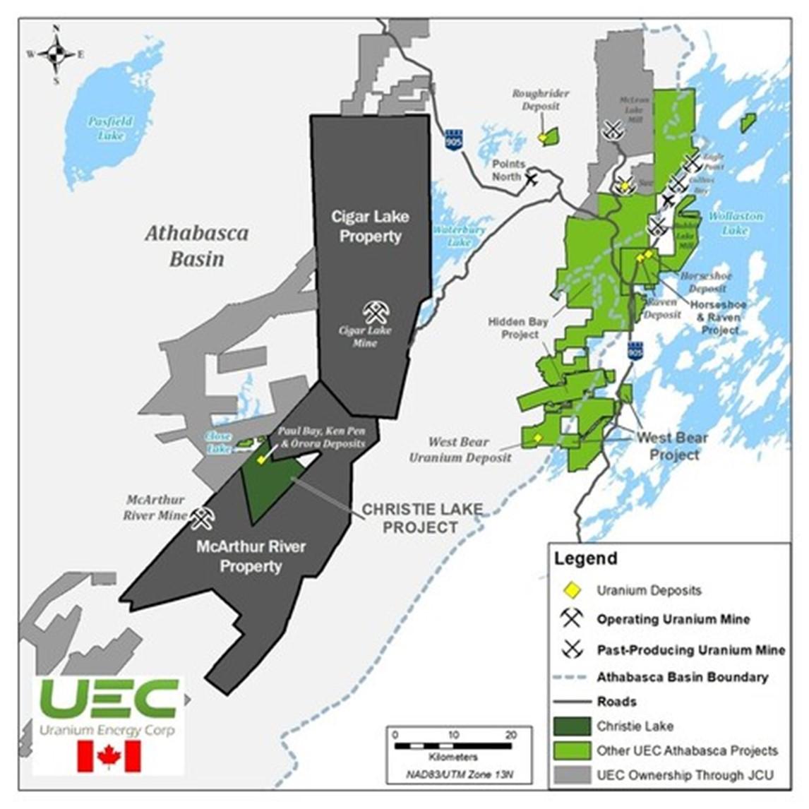
Figure 3 – Sakura Zone Mineralization – preliminary zone boundaries
Qualified Persons and Data Acquisition
The technical information in this news release has been reviewed and approved by Chris Hamel, P.Geo., UECs Vice President Exploration, Canada who is considered to be a Qualified Person as defined by S-K 1300.
Figure 4 – Preliminary Cross Section with CB-178-1
About Uranium Energy Corp
Uranium Energy Corp is the fastest growing supplier of the fuel for the green energy transition to a low carbon future. UEC is the largest, diversified North American focused uranium company, advancing the next generation of low-cost, environmentally friendly In-Situ Recovery mining uranium projects in the United States and high-grade conventional projects in Canada. The Company has two production-ready ISR hub and spoke platforms in South Texas and Wyoming. These two production platforms are anchored by fully operational central processing plants and served by seven U.S. ISR uranium projects with all their major permits in place. Additionally, the Company has diversified uranium holdings including: (1) one of the largest physical uranium portfolios of North American warehoused U3O8; (2) a major equity stake in Uranium Royalty Corp., the only royalty company in the sector; and (3) a Western Hemisphere pipeline of resource stage uranium projects. The Company’s operations are managed by professionals with decades of hands-on experience in the key facets of uranium exploration, development and mining.
Group Eleven Resources Corp. (TSX-V: ZNG) (OTCQB: GRLVF) (FSE: 3G... READ MORE
In response to shareholder questions, First Phosphate Corp. (CSE:... READ MORE
Imperial Metals Corporation (TSX:III) reports financial results f... READ MORE
“Wheaton’s portfolio of high-quality, long-life asset... READ MORE
Verde AgriTech Ltd. (TSX: NPK) (OTCQX: VNPKF) is pleased to annou... READ MORE


