








U.S. GoldMining Inc. (NASDAQ: USGO) is pleased to announce initial assay results from the first two diamond drill holes completed of its 2024 drilling program at the Whistler Gold-Copper Project in Alaska, U.S.A., which commenced in late June 2024. The results reported in this news release include WH24-01 drilled within the Raintree West Open Pit Deposit and the re-entry extension of drill hole WH23-03 within the Whistler Deposit.
Highlights:
| * AuEq equations are calculated consistent with the methodology outlined in Whistler Project technical reports “S-K 1300 Technical Report Summary Initial Assessment for the Whistler Project, South Central Alaska” with an effective date of September 22, 2022, available under the Company’s profile at www.sec.gov, and technical report titled “NI 43-101 Mineral Resource Estimate for the Whistler Project, South Central Alaska” with an effective date of September 22, 2022, available under the Company’s profile at www.sedarplus.ca. Specifically: below 10 g/t Ag: AuEq = Au + Cu*1.5733 + 0.0108*Ag, and above 10 g/t Ag: AuEq = Au + Cu*1.5733. |
Tim Smith, Chief Executive Officer of U.S. GoldMining, commented: “The 2023 drill program returned the longest drill intercept of consistent mineralization ever recorded at the Project: 547.2 meters at 1.06 g/t AuEq in WH23-03. We are further encouraged that we have now extended this by an additional +100 meters to enlarge the continuously mineralized intercept within the Whistler deposit high-grade core to 652.5 meters at 1.00 g/t AuEq. At Raintree, the drilling has returned both porphyry and vein-type mineralization, which both remain open along strike and to depth, warranting additional follow-up exploration. I want to acknowledge our professional and hard-working field teams that executed the 2024 exploration program safely, without a single lost time incident to date, and delivered on budget and ahead of schedule.”
2024 Drilling Program
As reported on June 27, 2024, the Company commenced diamond core drilling at the Raintree West deposit, before moving to the Whistler deposit in early July (see Figure 1).
The initial confirmatory infill drill hole at Raintree West aimed to elucidate the geological model and to also provide the potential to expand the existing resource. Confirmatory drill hole WH24-01 was drilled into the area of the mineral resource estimate constraining pit shell for the Raintree West Open Pit deposit, with the objective of collecting additional information about the style, geometry, continuity and controls on mineralization hosted therein.
Drilling at the Whistler deposit was aimed at further delineating and extending areas of high–grade mineralization to depth, building upon the success of the 2023 drilling program. Previously, WH23-03 was abandoned due to winter freeze-up in late October 2023, at 600.2 meters depth. Subsequently in July 2024 our drilling contractor successfully re-entered the drill hole and extended core sampling to 874.5 meters depth. Porphyry style mineralization was intersected to a depth of 717 meters within the drill hole, at which point it encountered barren country rock peripheral to the porphyry mineral system. WH23-03 assay results have further increased confidence in the continuity of mineralization within the Whistler deposit’s core of high-grade mineralization, which extends to surface and remains open to depth.
Drilling Results Discussion
Whistler Deposit
Combining assay results for both the original core drilled in 2023 to 600.2 meters downhole, and the 2024 re-entry and coring extended to 874.5 meters downhole, Whistler drill hole WH23-03 intersected 716.6 meters at 0.93 g/t AuEq from just below shallow soil cover at surface (0.41 meters depth) to 717.0 meters downhole. Gold, copper and silver mineralization was relatively consistent throughout the length of the overall intercept, with several zones of higher grade mineralization encountered including:
The Whistler Deposit is hosted within the Whistler Intrusive Suite, a composite of diorite stocks and dykes that divide the suite broadly into an early Main Stage Porphyry, a later Intermineral Porphyry Suite and a late intrusive phase referred to as the Late Stage Porphyry. Gold and copper mineralization is characterized by abundant disseminated sulphide and quartz + sulphide vein stockworks (including classic porphyry diagnostic ‘A’, ‘B’, ‘D’, and ‘M’ type veins), and potassic alteration which is variably overprinted by later phyllic alteration. The early-stage MSP suite is most strongly altered, veined and mineralized, with the IMP being less intensely altered and veined but remaining consistently mineralized, and the late or post-mineralization LSP generally containing below cut-off grade or being unmineralized. In addition, the Company’s technical team has identified the presence of a robust core of higher-grade mineralization within the deposit that correlates with intense alteration and B-veining within MSP in the eastern part of the intrusive suite.
WH23-03 infilled an area of previously sparse drilling on the southern margin of this ‘high-grade core’, with a corresponding lower-confidence resource classification. WH23-03 drilled at a steep angle on the southern margin of the high-grade core, aimed at improving confidence in grade continuity and achieving maximum depth penetration. The drill hole was designed to test for potential expansion of mineralization below the base of the current mineral resource constraining pit shell. WH23-03 demonstrated remarkable consistency of mineralization within the high-grade core, with near continuous mineralization encountered from surface to 717 meters depth, where it intersected barren country rock and LSP. The lower half of the drill hole intersected mineral resources currently classified as Inferred, thereby improving confidence in the geological model.
Raintree West Deposit
WH24-01 comprised a confirmatory drill hole into the Raintree West Open Pit deposit, targeting potential extensions of porphyry-style and distal (possibly epithermal) vein-style mineralization previously encountered in drilling. The drill hole also planned to extend below the existing mineral resource estimate constraining pit shell to test the interpreted presence of a shallow dipping fault that may offset the near surface (open pit) and deeper (underground) portions of the Raintree West deposit.
Drilling confirmed two styles of mineralization:
WH24-01 provided the first oriented core data within the Raintree deposit, which is being analyzed to help with improving future iterations of the geological and resource model, and to vector towards potential extension of mineralization. Both the porphyry-style and vein-style mineralization remain open along strike and to depth throughout the Raintree area.
Table 1 – Whistler Project drill assay intercepts from 2024 drilling program, received as of September 30, 2024, including intercepts for the entirety of WH23-03, which was re-entered in 2024 and extended from 600.2 to 874.5 m depth. Bold intervals correspond with those reported in ‘highlights’ section above.
| Hole Number |
Interval From (m) |
Interval To (m) |
Core Length (m) |
Gold Grade (g/t) |
Copper Grade (%) |
Silver Grade (g/t) |
AuEq (g/t)* |
Lead Grade (%) |
Zinc Grade (%) |
| WH23-03 | 0.41 | 717.00 | 716.59 | 0.68 | 0.15 | 1.40 | 0.93 | – | – |
| Including | 7.00 | 659.46 | 652.46 | 0.73 | 0.16 | 1.50 | 1.00 | – | – |
| Including | 131.00 | 307.00 | 176.00 | 1.24 | 0.19 | 1.66 | 1.55 | – | – |
| And | 373.50 | 423.00 | 49.50 | 0.92 | 0.10 | 1.82 | 1.10 | – | – |
| And | 441.00 | 457.00 | 16.00 | 1.03 | 0.20 | 1.64 | 1.36 | – | – |
| And | 480.00 | 501.00 | 21.00 | 0.80 | 0.35 | 2.11 | 1.37 | – | – |
| And | 523.00 | 539.00 | 16.00 | 0.83 | 0.30 | 1.14 | 1.31 | – | – |
| And | 575.00 | 632.00 | 57.00 | 1.07 | 0.17 | 1.18 | 1.36 | – | – |
| WH23-03 | 698.03 | 717.00 | 18.97 | 0.52 | 0.11 | 1.02 | 0.70 | ||
| WH24-01 | 107.00 | 109.00 | 2.00 | 0.45 | – | 8.60 | 0.58 | 0.61 | 3.07 |
| WH24-01 | 147.00 | 151.00 | 4.00 | 0.28 | – | 7.10 | 0.42 | 0.44 | 1.20 |
| WH24-01 | 159.00 | 161.00 | 2.00 | 0.64 | – | 4.50 | 0.72 | 0.29 | 1.59 |
| WH24-01 | 249.00 | 266.00 | 17.00 | 0.33 | 0.07 | 41.97 | 0.45 | 0.33 | 0.75 |
| Including | 249.00 | 253.00 | 4.00 | 0.78 | 0.22 | 171.55 | 1.12 | 1.19 | 2.53 |
| WH24-01 | 280.60 | 300.00 | 19.40 | 0.31 | – | 1.81 | 0.38 | 0.12 | 0.40 |
| Including | 284.00 | 286.00 | 2.00 | 1.23 | – | 4.70 | 1.32 | 0.37 | 1.27 |
| WH24-01 | 311.00 | 372.38 | 61.38 | 0.36 | 0.09 | 4.43 | 0.53 | 0.14 | 0.39 |
| Including | 321.00 | 362.00 | 41.00 | 0.41 | 0.11 | 5.43 | 0.61 | 0.15 | 0.49 |
| * AuEq equations are calculated consistent with the methodology outlined in Whistler Project technical reports “S-K 1300 Technical Report Summary Initial Assessment for the Whistler Project, South Central Alaska” with an effective date of September 22, 2022, available under the Company’s profile at www.sec.gov, and technical report titled “NI 43-101 Mineral Resource Estimate for the Whistler Project, South Central Alaska” with an effective date of September 22, 2022, available under the Company’s profile at www.sedarplus.ca. Specifically: below 10g/t Ag: AuEq=Au + Cu*1.5733 +0.0108Ag, and above 10g/t Ag: AuEq=Au + Cu*1.5733. AuEq calculations do not include Pb and Zn as it is unknown currently whether these metals can be recovered. |
Table 2 –Whistler Project drill hole collar location coordinates.
| Hole
Number |
Easting
Meters (UTM Zone 18) |
Northing
Meters (UTM Zone 18) |
Elevation
(m above sea level) |
Depth
(m) |
Azimuth
(Degrees) |
Dip
(Degrees) |
Status |
| WH23-01 | 518,782 | 6,871,260 | 886.0 | 467.87 | 140.80 | – 49.0 | All assays received |
| WH23-02 | 518,779 | 6,871,253 | 886.0 | 605.64 | 229.20 | – 60.1 | All assays received |
| WH23-03 | 518,776 | 6,871,253 | 886.0 | 874.50 | 189.20 | – 82.9 | All assays received |
| WH23-04 | 520,193 | 6,869,142 | 352.0 | 560.83 | 134.80 | – 78.0 | All assays received |
| WH24-01 | 520,494 | 6,871,260 | 497.0 | 445.77 | 14.63 | -46.9 | All assays received |
| WH24-02 | 518,452 | 6,871,362 | 849.0 | 716.30 | 135.43 | -75.2 | Assays Pending |
| WH24-03 | 518,746 | 6,871,335 | 859.0 | 961.9 | 309.69 | -80.1 | Assays Pending |
| WH24-04 | 518,680 | 6,871,248 | 876.0 | 832.20 | 185.85 | -78.0 | Assays Pending |
| WH24-05 | 520,495 | 6,871,258 | 497.0 | 777.85 | 184.37 | -55.3 | Assays Pending |
Technical Information
Tim Smith, P.Geo., Chief Executive Officer of U.S. GoldMining, has supervised the preparation of this news release and has reviewed and approved the scientific and technical information contained herein. Mr. Smith is a “qualified person” as defined in Canadian National Instrument 43-101 – Standards of Disclosure for Mineral Projects.
For details of the Whistler Gold-Copper Project mineral resource estimate see technical report “S-K 1300 Technical Report Summary Initial Assessment for the Whistler Project, South Central Alaska” with an effective date of September 22, 2022, available under the Company’s profile at www.sec.gov, or technical report titled “NI 43-101 Mineral Resource Estimate for the Whistler Project, South Central Alaska” with an effective date of September 22, 2022, available under the Company’s profile at www.sedarplus.ca.
Data Verification
For the Whistler Project drill core sampling program, samples were taken from the NQ/HQ core by sawing the drill core in half, with one-half sent to Bureau Veritas Commodities Canada Ltd. in Fairbanks for sample preparation, then to BV’s analytical laboratory in Vancouver, Canada for assaying, and the other half of the core is retained at the site for future reference. Sample lengths downhole were generally 2.0 m, except where samples were taken to honor geological contacts.
BV is a certified commercial laboratory and is independent of U.S. GoldMining. The Company has implemented a quality assurance and quality control program for the sampling and analysis of drill core samples, including duplicates, mineralized standards and blank samples for each batch of core samples. The gold analyses were completed by lead collection fire assay fusion with AAS finish (FA430 method) on 30 grams test weight. Copper, silver and other base metals (total suite of 45 elements) assays were assayed by 4-acid digestion and ICP-MS analysis (MA200 method) on 0.25 grams test weight.
About U.S. GoldMining Inc.
U.S. GoldMining Inc. is an exploration and development company focused on advancing the 100% owned Whistler Gold-Copper Project, located 105 miles (170 kilometers) northwest of Anchorage, Alaska, U.S.A. The Whistler Project consists of several gold-copper porphyry deposits and exploration targets within a large regional land package totaling approximately 53,700 acres (217.5 square kilometers).
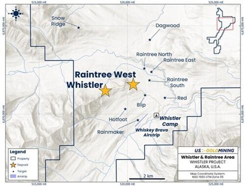
Figure 1 – Plan map of the northern section of the Whistler Project (see inset), showing the location of the Whistler and Raintree gold-copper-silver deposits. (CNW Group/U.S. GoldMining Inc.)
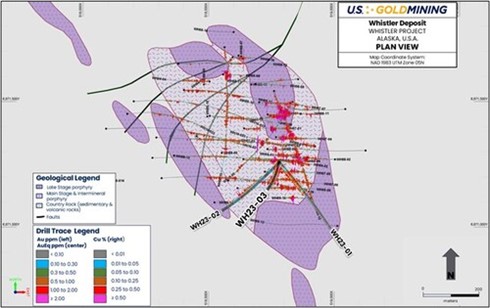
Figure 2 Whistler Deposit drill plan with gold and copper histograms plotted (left and right respectively; see legend). Traces for 2023 drill holes, including the re-entry of WH23-03 completed in 2024, are shown in bold (with prefix ‘WH23’). Drilling is overlain on a geological interpretation of the host diorite porphyry (cut at 200 meters below surface) to illustrate the overall geometry of mineralized porphyry phases (pale purple) and weak to non-mineralized late-stage porphyry phases (darker purple). (CNW Group/U.S. GoldMining Inc.)
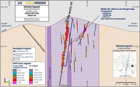
Figure 3 Whistler deposit, WH23-03 cross section view. (CNW Group/U.S. GoldMining Inc.)
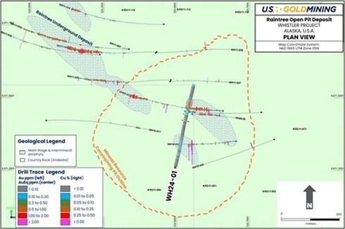
Figure 4 Raintree West Open Pit deposit drill plan with gold and copper histograms plotted (left and right respectively; see legend). Trace of WH240-01 is shown in bold. Drilling is overlain on a geological interpretation of the host diorite porphyry and volcanic (andesite) country-rock (cut at 200 meters below surface) to illustrate the overall geometry of mineralized porphyry phases (textured green units). (CNW Group/U.S. GoldMining Inc.)
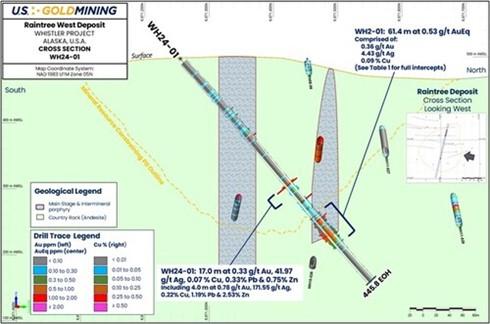
Figure 5 Raintree West deposit, WH24-01 cross section view. (CNW Group/U.S. GoldMining Inc.)
Critical Metals Corp. (Nasdaq: CRML) a leading critical minerals ... READ MORE
Holes SH26-22 and SH26-23 return up to 930 g/t AgEq within broade... READ MORE
Pasinex Resources Limited (CSE: PSE) (FSE: PNX) a growing zinc-fo... READ MORE
Aya Gold & Silver Inc. (TSX: AYA; NASDAQ: AYA) is pleased to... READ MORE
New Break Resources Ltd. (CSE: NBRK) (OTCQB: NBRKF) (FSE: O91) ha... READ MORE


