








Holes SH26-22 and SH26-23 return up to 930 g/t AgEq within broader mineralized horizons as ongoing step out drilling expands Silver Hill and the Company prepares for significantly larger step outs along strike
Metalsource Mining Inc. (CSE: MSM) (OTCQB: MSMMF) (FSE: E9Z) is pleased to announce additional assay results from its ongoing drill program at Silver Hill, where deep drilling continues to improve management’s understanding of the high grade polymetallic system. Hole SH26-22 returned 7.32 metres grading 261 g/t silver equivalent, including 1.37 metres grading 930 g/t AgEq from 245.67m. Hole SH26-23 returned 12.31 metres grading 140 g/t AgEq, including 1.86 metres grading 833 g/t AgEq from 246.8m.These two holes continue to demonstrate mineralization at depth, with reliable widths and high grades. SH26-06 returned minimal base metals, but identified multiple mineralized intervals containing gold (Au), including 0.4m of 3.1 g/t Au from 119.30m. Both holes intersected higher grade mineralization within broader mineralized horizons at depth, providing additional geological information as Metalsource continues step out drilling and prepares to significantly expand exploration along strike.
Ongoing drilling is currently stepping out from the known Silver Hill mineralization to test its continuation into previously untested ground. Building on this work, Metalsource is preparing a subsequent phase of significantly larger step outs to the north and south designed to test the broader strike potential of the mineralization. In parallel, expanded drilling capacity will allow the Company to begin testing priority IP anomalies beyond the historic mine footprint, several of which exhibit geophysical characteristics similar to those associated with Silver Hill proper.
| Drill Hole ID | From (m) | To (m) | Length (m) | Au (g/t) | Ag (g/t) | Pb (%) | Zn (%) | Cu (%) | AgEq (g/t) | ||||||||||||||||||||||||
| SH26-22 | 245.67 | 252.98 | 7.32 | 1.4 | 33.7 | 3.7 | 5.4 | 0.1 | 261 | ||||||||||||||||||||||||
| Including | 251.61 | 252.98 | 1.37 | 3.0 | 157.6 | 17.1 | 23.6 | 0.4 | 930 | ||||||||||||||||||||||||
| SH26-23 | 246.80 | 259.11 | 12.31 | 0.9 | 12.0 | 1.0 | 3.3 | 0.0 | 140 | ||||||||||||||||||||||||
| Including | 257.25 | 259. | .86 | 5.7 | 70.3 | 5.7 | 18.2 | 0.1 | 833 | ||||||||||||||||||||||||
| SH26-06 | 119.30 | 119.69 | 0.40 | 3.1 | 2.6 | 0.0 | 0.0 | 0.0 | 236 |
Table 1: Composite assay results with widths reported as core length. Additional data is needed to estimate the true width of intercepts at this stage of the project. *Details on AgEq calculations below.
Drillhole SH26-25 was drilled toward the WSW (Figure 3), and was designed to test the developing structural model of the project while investigating alteration assemblages on trend to the south of Silver Hill, and west of SH26-27. Although no mineralization was anticipated, SH26-25 provided valuable information about alteration intensity in hanging wall stratigraphy above the interpreted deep extension of Silver Hill mineralization. Strong quartz-sericite-pyrite + albite alteration was observed in the hanging wall rocks, stratigraphically above the down plunge projection of SH26-27. These results provide justification for deep exploration below SH26-27 and represent a potential for significant growth opportunity at Silver Hill.
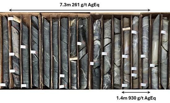
Figure 1: Panoramic photograph showing mineralization from SH26-22.
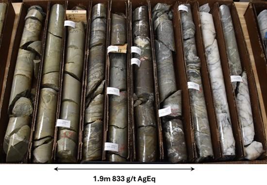
Figure 2: Photograph showing mineralization from SH26-23.
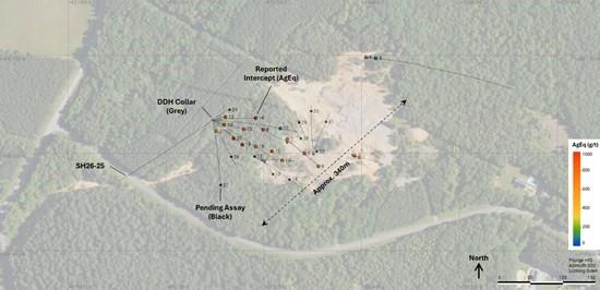
Figure 3: Plan view of the Silver Hill project area showing the location of drilled intercepts (AgEq), intercepts with pending assays (black) and collar locations (grey).
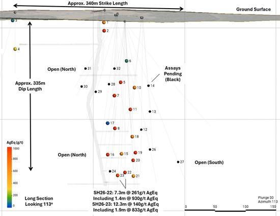
Figure 4: Long section looking southeast (113°) showing intercept locations colored by AgEq. Black dots indicate intercepts with pending assays.
Joe Cullen, CEO of Metalsource Mining, commented:
“SH26-22 and SH26-23 give us continued confidence in the continuity of the Silver Hill mineralization at depth. Together with the alteration we’re seeing farther south, we’re building an increasingly coherent picture of how this system is organized and where it may continue.
“We’re actively stepping out from the known system today, but what excites us most is where we’re preparing to take the program next. We intend to significantly increase the scale of our step out drilling to the north and south, while our second drill gives us the capacity to begin testing completely untested IP anomalies beyond the historic mine footprint, several of which exhibit geophysical characteristics similar to Silver Hill proper.
“Our strategy is simple: aggressively expand what we know while systematically testing what we have high confidence in to expand the footprint of mineralization. With two drills, multiple assays pending and a growing pipeline of targets, we’ve never been more excited about the opportunity in front of us.”
What’s Next
Why This Matters to Investors
SH26-22 and SH26-23 provide additional evidence supporting the continuity of the Silver Hill mineralization at depth, with both holes returning higher grade intervals within broader mineralized horizons. Together with the alteration observed farther south, the results continue to strengthen the Company’s geological understanding as drilling expands beyond the historically mined area.
The opportunity now extends well beyond the currently drilled footprint. Metalsource is actively stepping out from the known system and preparing significantly larger step outs to the north and south to test the broader strike potential across largely untested ground.
At the same time, the second drill provides the capacity to begin testing priority IP anomalies beyond Silver Hill proper, several of which exhibit geophysical characteristics similar to the known mineralization but remain completely untested by drilling.
| Drill Hole ID | Easting (m) | Northing (m) | Elev. (m) | Azimuth | Dip | Length (m) | Status |
| SH25-01 | 572408 | 3951597 | 229 | 107 | -63 | 109 | Complete |
| SH25-02 | 572408 | 3951597 | 229 | 96 | -85 | 101 | Complete |
| SH25-03 | 572410 | 3951751 | 226 | 96 | -46 | 305 | Complete |
| SH25-04 | 572410 | 3951751 | 225 | 352 | -89 | 100 | Complete |
| SH26-05 | 572280 | 3951624 | 222 | 125 | -73 | 199 | Complete |
| SH26-06 | 572280 | 3951624 | 222 | 129 | -51 | 154 | Complete |
| SH26-07 | 572280 | 3951624 | 222 | 74 | -89 | 200 | Complete |
| SH26-08 | 572280 | 3951624 | 222 | 297 | -77 | 231 | Complete |
| SH26-09 | 572237 | 3951590 | 218 | 89 | -70 | 15 | Abandoned |
| SH26-10 | 572237 | 3951590 | 218 | 91 | -76 | 188 | Complete |
| SH26-11 | 572237 | 3951590 | 218 | 26 | -83 | 197 | Complete |
| SH26-12 | 572237 | 3951590 | 218 | 293 | -84 | 255 | Assay Pending |
| SH26-13 | 572237 | 3951590 | 218 | 145 | -82 | 215 | Assay Pending |
| SH26-14 | 572237 | 3951590 | 218 | 125 | -67 | 185 | Assay Pending |
| SH26-15 | 572168 | 3951658 | 213 | 107 | -79 | 267 | Complete |
| SH26-16 | 572168 | 3951658 | 213 | 85 | -76 | 267 | Complete |
| SH26-17 | 572168 | 3951658 | 213 | 94 | -61 | 245 | Complete |
| SH26-18 | 572168 | 3951658 | 213 | 120 | -70 | 297 | Complete |
| SH26-19 | 572168 | 3951658 | 213 | 131 | -76 | 258 | Complete |
| SH26-20 | 572168 | 3951658 | 213 | 133 | -80 | 276 | Complete |
| SH26-21 | 572168 | 3951658 | 213 | 168 | -86 | 288 | Complete |
| SH26-22 | 572168 | 3951658 | 213 | 111 | -86 | 285 | Complete |
| SH26-23 | 572168 | 3951658 | 213 | 71 | -87 | 288 | Complete |
| SH26-24 | 572168 | 3951658 | 213 | 55 | -84 | 288 | Assay Pending |
| SH26-25 | 572168 | 3951658 | 213 | 236 | -49 | 241 | Assay Pending |
| SH26-26 | 572168 | 3951658 | 213 | 156 | -74 | 276 | Assay Pending |
| SH26-27 | 572168 | 3951658 | 213 | 173 | -67 | 283 | Assay Pending |
| SH26-28 | 572326 | 3951599 | 224 | 320 | -76 | 246 | Assay Pending |
| SH26-29 | 572326 | 3951599 | 224 | 334 | -68 | 188 | Assay Pending |
| SH26-30 | 572326 | 3951599 | 224 | 355 | -62 | 154 | Assay Pending |
| SH26-31 | 572326 | 3951599 | 224 | 19 | -60 | 139 | Assay Pending |
| SH26-32 | 572326 | 3951599 | 224 | 48 | -86 | 154 | Assay Pending |
Table 2: Drill collar locations and layout azimuth/dip for exploration drilling thus far at the Silver Hill Project. A recent collar survey and utilization of available LiDAR has improved collar locations and elevation estimates at Silver Hill.
Metalsource QA/QC protocols are maintained through the insertion of certified reference material (standards), blanks, and duplicates within the sample stream. The drill core is cut in half with a diamond saw, with one half placed in sealed bags and shipped to the laboratory and the other half retained on site. Chain of custody is maintained from the drill to the submittal into the laboratory preparation facility.
Analytical testing is performed by ALS Geochemistry (Reno, NV) and ALS Canada (Vancouver, BC). The entire sample is crushed to 70% passing 2mm mesh, with a 250 gram split pulverized to 85% passing minus 75 micron. A four-acid digest is performed on 0.25g of sample to quantitatively dissolve most geological materials. Analysis is performed with a combination of ICP-AES and ICP-MS and fire assay.
The exploration results described herein are preliminary in nature and are insufficient to define a mineral resource. Further drilling is required to determine the continuity, geometry, and grade distribution of mineralization. At the time of this release analytical results remain pending.
*Metal values used in AgEq calculations are from the 200-day moving average values from 2/6/2026, and all values are in USD. PAu= $124.5/g, PAg= $1.58/g, PCu= $4.9/lb, PPb=$0.90/lbs, PZn=$1.11/lb, 0.00220462262 = grams-to-pounds conversion factor, 22.0462262 = pounds per tonne for 1% metal. Metal recoveries used in the AgEq calculation are Au: 95.5%, Ag: 92.9%, Pb: 89.2%, Zn: 93.8% and Cu 90.8%. These recovery values are derived from batch metallurgical testing used to estimate recoveries of Silver Hill ores, completed in 1988. Individual metal values in the results table are composited values and not factored by recovery. Metal recoveries are applied to their respective component of the AgEq calculation only.

Qualified Person
All scientific and technical information has been reviewed and approved by Darcy Vis, B.Sc., P.Geo., President of Tripoint Geological Services Ltd., a contractor of the Company, and a Qualified Person as defined under National Instrument (“NI”) 43-101 – Standards of Disclosure for Mineral Projects.
Silver Hill Project
Located in the Carolina Terrane, the property is underlain by volcaniclastic and volcano-sedimentary rocks predominantly of Neoproterozoic and Cambrian age. Current interpretations suggest this terrane is an extension of the Avalon Terrane. The property is 1,300 acres located in Davidson County, North Carolina. As the first significant discovery and first silver-producing mine in America, the property is supported by an extensive historic dataset, including drillhole data, underground mapping, historic dumps and underground chip samples. Currently known mineralization extends to 550m from surface, in a steeply trending series of lenses, which remain open in multiple directions.
Byrd-Pilot Mountain Project
The Byrd-Pilot Mountain Project is located in central North Carolina within the Carolina Terrane. Initial USGS surveys in the 1980s identified the area as a potential host for a porphyry gold-copper system. Subsequent exploration demonstrated broad gold mineralization in soils, trenches, and shallow RC drilling, coincident with strong self-potential anomalies. Geology shows intense quartz-sericite-pyrite alteration, high-sulfidation signatures, and high-alumina minerals (like Haile and Brewer deposits to the south), suggesting potential for a large epithermal or porphyry-related gold system. Geologic modelling of currently identified mineralization indicates an east-west trend open in multiple directions, with oxidation noted down to a depth of 30m. No drilling has tested the Meridian discovery zone since those 1980s campaigns, leaving potential for significant resource expansion through work commitments of the agreement.
About Metalsource Mining Inc.
Metalsource Mining Inc. is a U.S.-focused precious and critical metals exploration company advancing the Silver Hill Project in North Carolina, widely recognized as America’s first silver mine. A historically producing mining district dating back to 1839, Silver Hill produced silver, gold, lead and zinc during the formative years of the American mining industry and remains one of the most historically significant mining assets in the United States.
The Company is focused on expanding known mineralization, advancing toward a modern resource estimate, and unlocking the broader potential of the Silver Hill district through systematic drilling, geological modeling and modern exploration techniques.
Brutus Mining Inc. (CSE: BRU) (FSE: ZI3) is pleased to announce that it has closed its non-brokered ... READ MORE
Jaguar Uranium Corp. (NYSE American: JAGU) is pleased to announce an independent Mineral Resource E... READ MORE
Auro Metals Inc. (TSX-V: AURO) (OTCQB: AURFF), is pleased to announce the assay results of the fina... READ MORE
Endeavour Silver Corp. (NYSE: EXK) (TSX: EDR) is pleased to announce that repairs to the primary bal... READ MORE
Scorpio Gold Corp. (NASDAQ: SGLD) (TSX-V: SGLD) (OTCQB: SRCRF) (FSE: RY9) is pleased to announce re... READ MORE


