


Titan Mining Corporation (TSX:TI) is pleased to provide an update on the ongoing Kilbourne exploration program. The Company has received assays from the initial phase of trenching and from the initial fifteen drill holes of the Company’s ongoing graphite exploration program. The first phase of exploration has been focused on mineralization within the fully permitted footprint of the Company’s 100% owned Empire State Mine in upstate New York.
Titan CEO Don Taylor commented, “We are very pleased with the results of the initial programs. The results have provided definitive evidence that the potential size and grade of the deposit are significant and present Titan with an early entry opportunity into the US graphite market. The Kilbourne target being tested is amenable to open pit mining on permitted ground.”
Surface drilling at Kilbourne has focused on delineating the thickness and grade of the historically documented graphite mineralization within the Company’s active mine permit. To date 21 core holes have been completed, totaling 7,357 ft (2,242 m) of drilling. The Company has received assays from 15 of the completed 21 holes.
Significant mineralized intercepts from drilling include:
The Company is pleased by the early success of the Phase I exploration program at Kilbourne. Graphite mineralization has been successfully tested from surface to vertical depths of 592 ft (180 m), and along a strike length of nearly 5,000 ft (1,524 m). All drilling has taken place within the Company’s active use permit. In Phase I an additional 11 holes are planned to test near surface mineralization within the remaining 3,500 ft (1,066.8 m) of target strike length.
In addition to the ongoing drill program, the Company completed 265 feet (80.7 m) of channel sampling, testing bedrock exposed through trenching. To date, 91 trench samples have been collected.
The assay results have continued to exceed expectations, with the grade of mineralized drill intercepts averaging 3.2% Cg (graphitic carbon). Individual samples within the mineralized zones have returned assays ranging up to 11.3 % Cg (KX24-007 from 165.0 ft to 168.2 ft, part of the noted 13 ft interval from 160.0 ft to 173.0 ft at 6.0% Cg).
As part of Phase I, representative drill core intervals of both the upper and lower mineralized zones have been selected for composite and metallurgical testing. Forte Analytics (formerly RDI) of Wheat Ridge, Colorado has been contracted to perform tests to evaluate processing options in order to maximize recovery and concentrate grades while maintaining the natural large flake size of the Kilbourne mineralization. Preliminary testing at SGS Labs in Lakefield, Ontario has shown that the Kilbourne Mineralization is able to be purified to a satisfactory quality, and that early size fraction analyses places the material in a suitable range for battery usage, and other applications.
Table I. Mineralized intercepts from underground exploration program
| 2023-2024 Kilbourne Drilling | |||||||||
| Hole ID | From (ft) | To (ft) | Interval (ft) | From (m) | To (m) | Interval (m) | Cg% | ||
| KX23-001 | 46.0 | 137.5 | 91.5 | 14.0 | 41.9 | 27.9 | 3.3 | ||
| 181.0 | 210.5 | 29.5 | 55.2 | 64.2 | 9.0 | 2.8 | |||
| KX24-002 | 28.8 | 112.7 | 83.9 | 8.8 | 34.4 | 25.6 | 3.3 | ||
| 155.0 | 169.2 | 14.2 | 47.2 | 51.6 | 4.3 | 3.1 | |||
| KX24-003 | 9.0 | 149.0 | 140.0 | 2.7 | 45.4 | 42.7 | 3.5 | ||
| 227.6 | 259.9 | 32.3 | 69.4 | 79.2 | 9.8 | 4.0 | |||
| KX24-004 | 8.0 | 181.5 | 173.5 | 2.4 | 55.3 | 52.9 | 3.7 | ||
| Including | 23.0 | 45.0 | 22.0 | 7.0 | 13.7 | 6.7 | 4.1 | ||
| and | 65.0 | 145.0 | 80.0 | 19.8 | 44.2 | 24.4 | 4.0 | ||
| 303.3 | 319.9 | 16.6 | 92.4 | 97.5 | 5.1 | 2.8 | |||
| KX24-005 | 54.0 | 89.0 | 35.0 | 16.5 | 27.1 | 10.7 | 3.4 | ||
| 161.0 | 175.0 | 14.0 | 49.1 | 53.3 | 4.3 | 2.7 | |||
| KX24-006 | 60.0 | 85.0 | 25.0 | 18.3 | 25.9 | 7.6 | 3.1 | ||
| 160.0 | 186.7 | 26.7 | 48.8 | 56.9 | 8.1 | 3.4 | |||
| KX24-007 | 50.0 | 95.0 | 45.0 | 15.2 | 29.0 | 13.7 | 3.1 | ||
| 149.6 | 181.5 | 31.9 | 45.6 | 55.3 | 9.7 | 4.4 | |||
| including | 160.0 | 173.0 | 13.0 | 48.8 | 52.7 | 4.0 | 6.0 | ||
| KX24-008 | 76.0 | 97.0 | 21.0 | 23.2 | 29.6 | 6.4 | 2.2 | ||
| 159.0 | 185.9 | 26.9 | 48.5 | 56.7 | 8.2 | 3.6 | |||
| KX24-009 | 484.0 | 535.4 | 51.4 | 147.5 | 163.2 | 15.7 | 2.2 | ||
| Including | 505.0 | 530.4 | 25.4 | 153.9 | 161.7 | 7.7 | 2.9 | ||
| 558.6 | 573.8 | 15.2 | 170.3 | 174.9 | 4.6 | 3.0 | |||
| KX24-010 | 455.0 | 534.5 | 79.5 | 138.7 | 162.9 | 24.2 | 2.2 | ||
| 575.0 | 587.7 | 12.7 | 175.3 | 179.1 | 3.9 | 2.5 | |||
| KX24-011 | 0.0 | 10.0 | 10.0 | 0.0 | 3.0 | 3.0 | 2.5 | ||
| 70.0 | 96.2 | 26.2 | 21.3 | 29.3 | 8.0 | 3.0 | |||
| KX24-012 | 0.0 | 11.0 | 11.0 | 0.0 | 3.4 | 3.4 | 3.8 | ||
| 90.0 | 102.7 | 12.7 | 27.4 | 31.3 | 3.9 | 2.2 | |||
| KX24-013 | 77.5 | 98.4 | 20.9 | 23.6 | 30.0 | 6.4 | 3.3 | ||
| KX24-014 | 96.4 | 121.4 | 25.0 | 29.4 | 37.0 | 7.6 | 2.4 | ||
| KX24-015 | 330.0 | 410.0 | 80.0 | 100.6 | 125.0 | 24.4 | 3.6 | ||
| 441.0 | 470.5 | 29.5 | 134.4 | 143.4 | 9.0 | 3.2 | |||
Note: The true width of the mineralization is not currently known.
Table II. Collar Location
| Kilbourne Collars | ||||||||
| Hole ID | Length (ft) | Easting (ft) | Northing (ft) | Elevation (ft) | Azimuth | Dip | ||
| KX23-001 | 270 | 13481.5 | 13275.9 | 608.8 | 0 | -90 | ||
| KX24-002 | 256 | 13484.4 | 13274.0 | 608.5 | 120 | -50 | ||
| KX24-003 | 315 | 13081.1 | 12684.6 | 640.5 | 160 | -50 | ||
| KX24-004 | 356 | 13082.4 | 12681.0 | 640.5 | 0 | -90 | ||
| KX24-005 | 240.8 | 12578.1 | 12302.5 | 653.1 | 0 | -90 | ||
| KX24-006 | 209 | 12580.5 | 12299.7 | 652.6 | 140 | -50 | ||
| KX24-007 | 209 | 12201.5 | 11701.7 | 643.1 | 0 | -90 | ||
| KX24-008 | 221 | 12204.0 | 11699.5 | 643.3 | 130 | -50 | ||
| KX24-009 | 644 | 11642.2 | 12592.8 | 641.6 | 140 | -50 | ||
| KX24-010 | 636 | 11648.7 | 12600.1 | 641.6 | 110 | -50 | ||
| KX24-011 | 165 | 11404.5 | 11065.6 | 636.5 | 140 | -50 | ||
| KX24-012 | 157 | 11401.5 | 11067.6 | 636.2 | 140 | -90 | ||
| KX24-013 | 126 | 12018.4 | 11394.5 | 641.5 | 0 | -90 | ||
| KX24-014 | 167 | 12020.6 | 11391.3 | 641.4 | 140 | -50 | ||
| KX24-015 | 544 | 13115.4 | 13636.2 | 609.3 | 130 | -50 | ||
Table III. Results from the Kilbourne Trenching Program
| 2023 Kilbourne Trenching | ||||||||||
| Trench ID | Segment | From (ft) | To (ft) | Interval (ft) | From (m) | To (m) | Interval (m) | Cg% | ||
| KT23-001 | KT23-001A | 0.0 | 55.0 | 55.0 | 0.0 | 16.8 | 16.8 | 3.2 | ||
| KT23-001B | 0.0 | 42.0 | 42.0 | 0.0 | 12.8 | 12.8 | 2.7 | |||
| KT23-001C | 0.0 | 42.0 | 42.0 | 0.0 | 12.8 | 12.8 | 3.5 | |||
| KT23-001D | 0.0 | 42.0 | 42.0 | 0.0 | 12.8 | 12.8 | 1.8 | |||
| KT23-002 | KT23-002A | 0.0 | 84.0 | 84.0 | 0.0 | 25.6 | 25.6 | 2.6 | ||
Table IV. Trench Segment Start and End Points
| Kilbourne Trenching – Start and End Points | ||||||||
| Trench ID | Point | Length (ft) | Easting (ft) | Northing (ft) | Elevation (ft) | Azimuth | ||
| KT23-001 A | Start | 55 | 12660.0 | 13054.0 | 641.0 | 255 | ||
| KT23-001 A | End | 12674.7 | 13108.6 | 636.1 | ||||
| KT23-001 B | Start | 42 | 12668.7 | 13110.8 | 635.8 | 261 | ||
| KT23-001 B | End | 12677.2 | 13148.4 | 634.8 | ||||
| KT23-001 C | Start | 42 | 12672.6 | 13148.2 | 634.7 | 240 | ||
| KT23-001 C | End | 12694.0 | 13182.1 | 637.1 | ||||
| KT23-001 D | Start | 42 | 12699.8 | 13188.8 | 638.6 | 254 | ||
| KT23-001 D | End | 12712.0 | 13229.0 | 639.0 | ||||
| KT23-002 A | Start | 88 | 13175.7 | 13976.8 | 643.0 | 309 | ||
| KT23-002 A | End | 13228.3 | 13911.9 | 641.1 | ||||
All trench samples collected from within 6 inches (15.2 cm) of the bedrock surface.
Figure 1. Location of the Kilbourne Project relative to ESM Operations, solid hollow shape represents the active mine area currently permitted.

Figure 2. Plan view of drilling showing the location of Kilbourne Exploration holes, planned drill holes, and trenching.
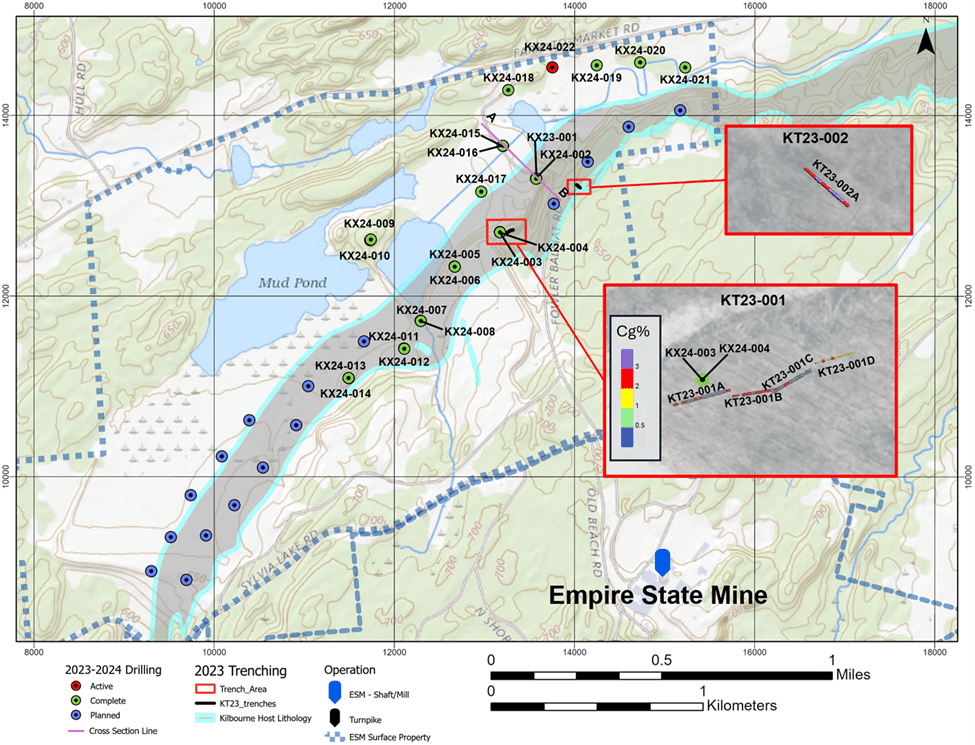
Figure 3. Cross section showing host lithologies with assays from 2023-2024 drilling. Highlighted are holes KX23-001, KX24-002, and KX24-015.

Looking North East, section line marked on Figure 2.
Qualified Person
The scientific and technical information contained in this news release and the sampling, analytical and test data underlying the scientific and technical information has been reviewed, verified and approved by Donald R. Taylor, MSc., PG, President and Chief Executive Officer of the Company, a qualified person for the purposes of NI 43-101. Mr. Taylor has more than 25 years of mineral exploration and mining experience and is a Registered Professional Geologist through the SME (registered member #4029597). Mr. Taylor verified the data disclosed, including sampling, analytical, and test data underlying the information included in this news release for which he is responsible, by performing a number of checks to confirm the accuracy of such data. In addition, Mr. Taylor reviewed the QA/QC reports from the Company’s drill programs and noted that there were no issues that arose which would affect confidence with the assay data.
Assays and Quality Assurance/Quality Control
To ensure reliable sample results, the Company has a rigorous QA/QC program in place that monitors the chain-of-custody of samples and includes the insertion of blanks and certified reference standards at statistically derived intervals within each batch of samples. Core is photographed and split in half with one-half retained in a secured facility for verification purposes. Drill core samples submitted for analysis had a minimum weight of 0.6 lb (0.3 kg) and a maximum weight of 6.0 lb (2.7 kg), with an average weight of 3.6 lb (1.6 kg). Trench samples submitted for analysis had a minimum weight of 4.2 lb (1.9 kg) and a maximum weight of 26.2 lb (11.9 kg), with an average weight of 6.2 lb (13.6 kg).
Analysis has been performed at SGS Canada Inc. an independent ISO/IEC accredited lab. Sample preparation (crushing and pulverizing) and total graphitic carbon analysis has been completed at SGS Lakefield, Ontario, Canada. SGS prepares a pulp of all samples and sends the pulps to their analytical laboratory in Burnaby, B.C., Canada for multielement analysis. SGS analyzes the pulp sample by leach and IR combustion for total graphitic carbon (GC_CSA05V) and aqua regia digestion (GE-ICP21B20 for 34 elements) with an ICP – OES finish including Cu (copper), Pb (lead), and Zn (zinc). All samples in which Cu (copper), Pb (lead), or Zn (zinc) are greater than 10,000 ppm are re-run using aqua regia digestion (GO_ICP21B100) with the elements reported in percentage (%).
The Company has not identified any drilling, sampling, recovery, or other factors that could materially affect the accuracy or reliability of the data set out in this news release. True widths of the mineralized zones described in this news release are not presently known.
About Titan Mining Corporation
Titan is an Augusta Group company which produces zinc concentrate at its 100%-owned Empire State Mine located in New York state. Titan is built for growth, focused on value and committed to excellence.
Abcourt Mines Inc. (TSX-V: ABI) (OTCQB: ABMBF) continues its work... READ MORE
Premier American Uranium Inc. (TSX-V: PUR) (OTCQB: PAUIF) is plea... READ MORE
Gladiator Metals Corp. (TSX-V: GLAD) (OTCQB: GDTRF) (FSE: ZX7) is... READ MORE
Bullion Gold Discoveries Corp. (TSX-V: BGD) is pleased to announc... READ MORE
Trident Resources Corp. (TSXV: ROCK) (OTCQB: TRDTF) (Frankfurt: ... READ MORE


