


Talon Metals Corp. (TSX: TLO) is pleased to announce that 7.14 meters (23.4 feet) of Mixed Massive Sulphides has been intersected at the Tamarack Nickel-Copper-Cobalt project, located in Minnesota, USA. The Tamarack Project comprises the Tamarack North Project and the Tamarack South Project.
Highlights:
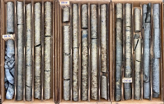
FIGURE 1: DRILL CORE FROM DRILL HOLE 12TK0153C: PHOTO FROM ~581 METERS TO ~589 METERS
“Our winter 2020 drill program has now been successfully completed, and we believe the results are fantastic”, said Henri van Rooyen, CEO of Talon. “Today’s announcement includes three new positive developments – (1) intersecting 7.14 meters (23.4 feet) of mixed massive sulphides (with assays pending); (2) intersecting an additional 115 meters (378 feet) of Mixed Zone mineralization (with assays pending); and (3) identifying a possible extension of our high-grade Massive Sulphide Unit outside of the resource area.”
“We believe that this drill program reiterates to the market that the Tamarack Project is a high-quality, high-grade project that is well positioned to deliver additional shareholder value as the project further progresses. We look forward to sharing the results of the outstanding assays once they are received,” said Sean Werger, President of Talon.
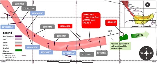
FIGURE 2: PLAN VIEW OF THE SOUTHERN PORTION OF THE HIGH-GRADE MASSIVE SULPHIDE UNIT WITHIN THE TAMARACK ZONE BELOW THE 138 ZONE. THE MAP SHOWS THE LOCATION OF NEW DRILL HOLES 12TK0153C, 12TK0153B AND PREVIOUS DRILL HOLE 14TK0206, AND THEIR LOCATION RELATIVE TO PREVIOUS DRILL HOLES 12TK0153 AND 13TK0171
Drill Hole: Objective, Design and Results
The primary objective of drill hole 12TK0153C was to test continuity of the high-grade Massive Sulphide Unit between previous drill holes 12TK153 and 13TK0171, with the distance in between these drill holes being approximately 50 meters (164 feet) (see Figure 3). Drill hole 12TK0153 intersected 12.19 meters (40 feet) of MMS grading 6.85% Ni, 3.02% Cu, 0.12% Co, 0.50 g/t Pd, 0.49 g/t Pt and 0.12 g/t Au (8.38% NiEq1) starting at 555.86 meters, and drill hole 13TK0171 intersected 7.34 meters (24.1 feet) of MMS grading 8.3% Ni, 2.95% Cu, 0.15% Co, 0.93 g/t PGEs and 0.19 g/t Au (9.81% NiEq) starting at 573.3 meters.
Drill hole 12TK0153C was designed to intercept the MMS hosted in the sediment wedge which is found between the Fine Grained Orthocumulate/Mixed Zone and Coarse Grained Orthocumulate. The lithological sequence was predicted to be similar to previous drill holes 12TK0153 and 12TK0171.
As a result, drill hole 12TK0153C successfully intersected 7.14 meters (23.4 feet) of MMS at the predicted elevation (starting at 578.45 meters), approximately 30 meters (98 feet) to the east of drill hole 12TK0153 and 20 meters (66 feet) to the west of drill hole 13TK0171.
The primary objective of drill hole 12TK0153B was to test the edge of a Borehole Electromagnetic anomaly from previous drill hole 12TK0153 that extended beyond the northern edge of the Company’s resource area. Drill hole 12TK0153B was drilled approximately two meters north of the Company’s resource area and did not intersect significant mineralization; however, a BHEM survey conducted on 12TK0153B identified a strong off-hole BHEM anomaly to the south back towards drill hole 12TK0153 where the Company’s resource area is located.
With respect to drill hole 12TK0153C, assays for the observed MMS intercept of 7.14 meters (23.4 feet) and the MZNO mineralization intercept of 115 meters (378 feet) above the MMS intercept are still pending.
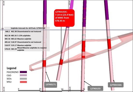
FIGURE 3. LONG SECTIONS LOOKING SOUTH. SOUTHERN PORTION OF THE TAMARACK ZONE HIGH-GRADE MASSIVE SULPHIDE UNIT BELOW THE 138 ZONE. SECTION SHOW THE POSITION OF HOLE 12TK0153C WITH RESPECT TO 13TK0171 AND 12TK0153.
Geophysical Survey Results
During the Company’s winter 2020 exploration program, the Company has been testing different geophysical methods to try and extend the high-grade MSU. The results of one of the BHEM surveys has identified three stacked BHEM anomalies south of drill hole 14TK0206 (see Figure 2) at a depth of 575 meters to 600 meters. This depth corresponds to the depth of the high-grade MSU in previous drill holes 12TK0153C and 13TK0171. The BHEM anomaly corresponds to a 55 meter step-out from hole 13TK0171 and could represent the down plunge continuation of the high-grade MSU.
We look forward to providing further results from assays and geophysical data processing and interpretation when these become available.
Quality Assurance, Quality Control and Qualified Persons
Please see the technical report entitled “NI 43-101 Technical Report Updated Preliminary Economic Assessment (PEA) of the Tamarack North Project – Tamarack, Minnesota” with an effective date of March 12, 2020 prepared by independent “Qualified Persons” (as that term is defined in National Instrument 43-101 Leslie Correia (Pr. Eng), Andre-Francois Gravel (P. Eng.), Tim Fletcher (P. Eng.), Daniel Gagnon (P. Eng.), David Ritchie (P. Eng.), Oliver Peters (P. Eng.), Christine Pint (P.G.) and Brian Thomas (P. Geo.) for information on the QA/QC, analytical and testing procedures at the Tamarack Project. Copies are available on the Company’s website (www.talonmetals.com) or on SEDAR at (www.sedar.com). The laboratory used is ALS Minerals who is independent of the Company.
Lengths are drill intersections and not necessarily true widths. True widths cannot be consistently calculated for comparison purposes between holes because of the irregular shapes of the mineralized zones. Drill intersections have been independently selected by Talon. Drill composites have been independently calculated by Talon. The geological interpretations in this news release are solely those of the Company.
The locations and distances highlighted on all maps in this news release are approximate.
Dr. Etienne Dinel, Vice President, Geology of Talon, is a Qualified Person within the meaning of NI 43-101. Dr. Dinel is satisfied that the analytical and testing procedures used are standard industry operating procedures and methodologies, and he has reviewed, approved and verified the technical information disclosed in this news release, including sampling, analytical and test data underlying the technical information.
About Talon
Talon is a TSX-listed base metals company in a joint venture with Rio Tinto on the high-grade Tamarack Nickel-Copper-Cobalt Project located in Minnesota, USA, comprised of the Tamarack North Project and the Tamarack South Project. Talon has an earn-in right to acquire up to 60% of the Tamarack Project. The Tamarack Project comprises a large land position (18km of strike length) with numerous high-grade intercepts outside of the current resource area. Talon is focussed on expanding its current high-grade nickel mineralization resource prepared in accordance with NI 43-101; identifying additional high-grade nickel mineralization; and developing a process to potentially produce nickel sulphates responsibly for batteries for the electric vehicles industry. Talon has a well-qualified mine management team with extensive experience in project management.
Significant copper and molybdenum intersections include: HM09: 13... READ MORE
Aya Gold & Silver Inc. (TSX: AYA) (OTCQX: AYASF) is pleased t... READ MORE
Key Highlights – Preliminary Economic Assessment Pre-Tax Net Pr... READ MORE
Aris Mining Corporation (TSX: ARIS) (NYSE-A: ARMN) announces its ... READ MORE
Orla Mining Ltd. (TSX: OLA) (NYSE: ORLA) announces the results fo... READ MORE


