


Superior Gold Inc. (TSX-V: SGI) is pleased to announce high-grade drill results from its ongoing underground diamond drill program at its 100%-owned Plutonic Gold mine in Western Australia. Plutonic is a world-class Archean lode-style gold mineralized system that has produced close to six million ounces of gold to date and encompasses a Measured and Indicted Mineral Resource of 1.89 million ounces together with an Inferred Mineral Resource of 3.07 million ounces. The Company’s continuous exploration effort underpins a commitment to resource growth.
Results are provided for 52 underground exploration drill holes for a total of 8,451 metres of drilling. Drilling was focused on extending and infilling the Western Mining Front which remains open along strike and both up and down dip as it is yet to be fully drill tested.
HIGHLIGHTS
The location of this drilling is shown in Figures 1-4 below. The key intersections are shown in Table 1 and Table 2 below and all intersections are provided in Table 3. Reported intersections are over a minimum downhole length of 0.30 metres (0.20 metres true width).
Chris Jordaan, President and CEO of Superior Gold stated: “We are delighted to announce today’s drill results, clearly extending the new high-grade Western Mining Front. Today’s drill results extends the western edge of the Plutonic deposit a further approximately 60 metres along the entire Western Mining Front currently estimated to be 1.6 kilometre long from surface to Baltic West. They also support our view that this new northwest high-grade trend, known as the Guppy Trend, continues through an area not previously drilled, opening a much larger target area than previously considered.
Results to date support our view that the Western Mining Front has excellent potential to be an important new gold production zone at Plutonic. In addition, today’s results are not included in our current Mineral Resource estimate.
The expansion into new mining fronts is a key component of our current strategy to extend Plutonic’s mine life and increase production by further improving our mining grades and efficiencies. Our ongoing drill program, utilizing our dedicated exploration drill rig, will continue to infill the Western Mining Front with the aim of including parts of this area in the 2022 mine plan.”
EXTENSION OF THE WESTERN MINING FRONT
Superior Gold’s mine exploration program is designed to open new mining fronts by targeting extensions of high-grade mineralization that are close to existing infrastructure but outside of the current Mineral Resources. Numerous significant historical high-grade intercepts, both throughout and peripheral to the large mineralized Plutonic system, have yet to be followed up. The immediate focus is on expanding two key areas to open new mining fronts, these being: 1) The Western Mining Front (along the Caspian, Indian and Baltic zones); and 2) The Baltic Gap as shown in Figure 4.
The Western Mining Front extends approximately 1.6 kilometre along the western edge of the Caspian, Indian and Baltic zones of the Plutonic underground mine and remains open, with several historic high-grade intercepts confirming mineralization continuity outside of Mineral Resources, as shown in Figure 4.
Drilling in 2020 identified significant high-grade mineralization in the northwest of the Indian zone, including 56.3 g/t gold over 15.1 metres (hole UDD22011) (refer to the News Release dated June 17, 2020). Drilling in the first quarter of 2021 identified the northwest extension of these high-grade bands of mineralization, 350 metres down dip in the Baltic zone, including 13.7 g/t gold over 8.8 metres (hole UDD23656) (refer to the News Release dated March 1, 2021).
Today’s Western Mining Front drill results extend from the Caspian zone, down through the Indian and Baltic zones to the Baltic Extension zone – covering up to a 1.6 kilometre long northwest extension of the Western Mining Front. Results are clustered in three general areas 1) Caspian zone, 2) Baltic West zone and 3) Baltic Extension zone as shown in Figures 1 and 2.
The Caspian zone results include 42.2 g/t gold over 5.6 metres (hole UDD24141), extending the Caspian zone along the northwest Guppy Trend, which is now thought to extend the entire 1.6 kilometre length of the Western Mining Front.
The Baltic West zone also includes results along the Guppy Trend, located between the Indian zone and Baltic zone results (noted above), approximately 50 metres up dip from the March 2021 Baltic zone results and 170 metres west of the current Mineral Resource envelope. Consistent grade bearing intersections, including 140.4 g/t gold over 1.4 metres (grade control hole UDD23993) and 10.1 g/t gold over 4.0 metres (hole UDD24191), further demonstrate continuity of the typical Plutonic mineralization system, being a high-grade stacked lode system.
The Baltic Extension zone results include 17.7 g/t gold over 6.4 metres (hole UDD24376) and 6.4 g/t gold over 5.9 metres (hole UDD 24379), up to 100 metres northwest of the existing Mineral Resource envelope. These results support continuity with historical high-grade step out intercepts, such as 6.7 g/t gold over 6.8 metres (hole PEDD0221), which demonstrates a 620 metre strike of high-grade mineralization, including today’s results.
Today’s results also support the hypothesis that the highest grades at Plutonic are controlled by the northwest trending faults. These results are also adjacent and in close proximity to existing infrastructure which translates to minimal capital expenditures required to infill drill and develop the area.
Figure 1: Mineralized Zones at Plutonic Underground with Drill Hole Locations (Plan View)
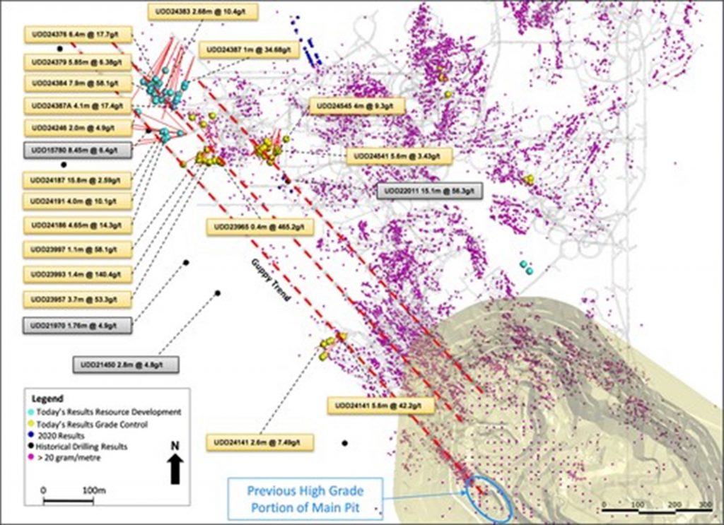
Figure 2: Western Mining Front Extension Third Quarter 2021 Drill Hole Locations (Plan View)
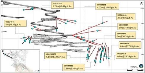
Figure 3: Western Mining Front Significant Intercept Location (Cross Section – Looking South)
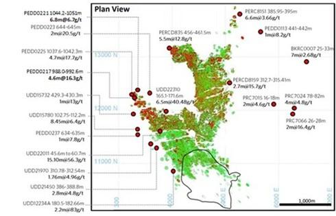
Figure 4: Plutonic Historical Significant Intercepts and Targeted New Mining Fronts (Plan View)
Table 1: Highlights of Expansion Drill Results from Western Mining Front
| Drill Hole # | Easting (Mine Grid) | Northing (Mine Grid) | Drill hole collar RL (Mine Grid) | Dip (degrees) | Azimuth (degrees, Mine Grid) | End of hole depth (m) | Downhole From (m) | Downhole To (m) | Downhole Intersection (m) | Au (gpt) uncut | Est True Thickness | ||
| UDD24186 | 3608 | 11695 | 914 | -18 | 259 | 141 | 54.0 | 58.7 | 4.7 | 3.1 | 3.3 | ||
| UDD24187 | 3608 | 11696 | 914 | -23 | 275 | 125 | 55.2 | 71.0 | 15.8 | 2.6 | 11.1 | ||
| UDD24191 | 3607 | 11697 | 914 | -23 | 290 | 210 | 67.2 | 71.2 | 4.0 | 10.1 | 2.8 | ||
| 60.1 | 63.3 | 3.2 | 3.0 | 2.2 | |||||||||
| UDD24221 | 4566 | 11317 | 1225 | 15 | 298 | 80 | 54.4 | 57.8 | 3.4 | 6.9 | 2.4 | ||
| UDD24246 | 3607 | 11697 | 916 | 25 | 294 | 183 | 155.6 | 157.6 | 2.0 | 5.0 | 1.4 | ||
| UDD24263 | 3571 | 11961 | 900 | -31 | 214 | 246 | 175.8 | 176.8 | 1.0 | 8.7 | 0.7 | ||
| UDD24374 | 3573 | 11959 | 900 | -25 | 206 | 186 | 162.2 | 165.4 | 3.2 | 2.9 | 2.2 | ||
| UDD24376 | 3573 | 11959 | 899 | -30 | 204 | 205 | 159.3 | 165.7 | 6.4 | 17.7 | 4.5 | ||
| UDD24377 | 3573 | 11959 | 900 | -21 | 203 | 180 | 133.4 | 134.4 | 1.0 | 30.4 | 0.7 | ||
| 171.8 | 172.8 | 1.0 | 12.3 | 0.7 | |||||||||
| UDD24378 | 3584 | 11947 | 899 | -36 | 205 | 201 | 177.3 | 178.1 | 0.8 | 25.3 | 0.6 | ||
| 191.0 | 193.0 | 2.0 | 6.3 | 1.4 | |||||||||
| 185.0 | 186.0 | 1.0 | 12.0 | 0.7 | |||||||||
| 106.0 | 106.5 | 0.5 | 17.3 | 0.4 | |||||||||
| UDD24379 | 3584 | 11947 | 900 | -29 | 205 | 209 | 161.0 | 166.8 | 5.8 | 7.0 | 4.1 | ||
| 153.1 | 159.0 | 5.9 | 6.4 | 4.1 | |||||||||
| UDD24380 | 3584 | 11947 | 900 | -17 | 205 | 211 | 165.0 | 166.1 | 1.1 | 8.2 | 0.8 | ||
| UDD24382 | 3593 | 11938 | 899 | -32 | 201 | 207 | 189.0 | 193.0 | 4.0 | 5.0 | 2.8 | ||
| UDD24383 | 3593 | 11938 | 899 | -39 | 200 | 204 | 175.5 | 178.2 | 2.7 | 10.4 | 1.9 | ||
| UDD24386 | 3600 | 11933 | 899 | -31 | 194 | 198 | 183.0 | 189.3 | 6.3 | 2.6 | 4.4 | ||
| UDD24387 | 3627 | 11906 | 898 | -31 | 200 | 123 | 89.5 | 90.5 | 1.0 | 34.7 | 0.7 | ||
| UDD24387A | 3627 | 11906 | 898 | -32 | 203 | 192 | 171.0 | 175.1 | 4.1 | 17.5 | 2.9 | ||
| 143.9 | 145.7 | 1.8 | 4.5 | 1.3 | |||||||||
| UDD24388A | 3627 | 11906 | 898 | -39 | 202 | 178 | 140.1 | 143.2 | 3.1 | 3.7 | 2.2 | ||
| Note: Mine grid co-ordinates shown. | |||||||||||||
Table 2: Highlights of Infill Drill Results from Western Mining Front
| Drill Hole # | Easting (Mine Grid) | Northing (Mine Grid) | Drill hole collar RL (Mine Grid) | Dip (degrees) | Azimuth (degrees, Mine Grid) | End of hole depth (m) | Down hole From (m) | Down hole To (m) | Downhole Intersection (m) | Au (gpt) uncut | Est True Thickness | ||
| UDD23870 | 4734 | 10726 | 1350 | 1 | 329 | 153 | 117.7 | 121.3 | 3.6 | 9.9 | 2.5 | ||
| UDD24130 | 3683 | 11670 | 998 | -13 | 328 | 108 | 61.7 | 62.6 | 0.9 | 23.2 | 0.6 | ||
| UDD24139 | 4043 | 11157 | 1158 | 9 | 232 | 84 | 19.1 | 20.9 | 1.8 | 11.8 | 1.3 | ||
| UDD24141 | 4042 | 11157 | 1158 | 12 | 243 | 102 | 20.0 | 25.6 | 5.6 | 42.2 | 3.9 | ||
| UDD24200 | 4628 | 10733 | 1362 | -7 | 359 | 138 | 111.3 | 117.1 | 5.8 | 6.6 | 4.1 | ||
| UDD24201 | 4628 | 10733 | 1362 | -7 | 14 | 165 | 114.4 | 120.7 | 6.3 | 7.4 | 4.4 | ||
| UDD24202 | 4627 | 10732 | 1362 | -5 | 9 | 141 | 67.2 | 70.5 | 3.3 | 7.0 | 2.3 | ||
| UDD24203 | 4752 | 10947 | 1343 | -1 | 221 | 141 | 115.1 | 119.3 | 4.2 | 9.7 | 2.9 | ||
| UDD24207 | 4752 | 10947 | 1343 | 2 | 215 | 174 | 139.4 | 144.2 | 4.8 | 10.5 | 3.4 | ||
| 130.1 | 133.6 | 3.5 | 7.2 | 2.5 | |||||||||
| UDD24208 | 4752 | 10947 | 1343 | 2 | 220 | 165 | 134.5 | 135.9 | 1.4 | 14.9 | 1.0 | ||
| UDD24209 | 4752 | 10947 | 1343 | -1 | 225 | 168 | 117.0 | 119.2 | 2.2 | 13.4 | 1.5 | ||
| UDD24298 | 4289 | 11901 | 938 | 12 | 174 | 62 | 50.1 | 52.3 | 2.2 | 31.9 | 1.5 | ||
| 25.5 | 27.2 | 1.7 | 13.2 | 1.2 | |||||||||
| UDD24362 | 4655 | 11015 | 1280 | -63 | 162 | 66 | 36.4 | 40.5 | 4.1 | 6.2 | 2.9 | ||
| UDD24363 | 4656 | 11015 | 1280 | -51 | 139 | 84 | 66.8 | 71.1 | 4.3 | 5.2 | 3.0 | ||
| UDD24365 | 4651 | 11017 | 1280 | -85 | 223 | 77 | 48.7 | 55.9 | 7.2 | 5.3 | 5.0 | ||
| UDD24367 | 4655 | 11015 | 1280 | -67 | 137 | 84 | 62.5 | 72.5 | 10.0 | 6.9 | 7.0 | ||
| UDD24368 | 4656 | 11015 | 1280 | -59 | 148 | 81 | 60.2 | 68.2 | 8.0 | 3.9 | 5.6 | ||
| UDD24480 | 4455 | 11171 | 1249 | -16 | 243 | 24 | 3.8 | 6.2 | 2.4 | 11.2 | 1.7 | ||
| UDD24545 | 3858 | 11708 | 910 | -13 | 196 | 102 | 92.6 | 96.6 | 4.0 | 9.4 | 2.8 | ||
| UDD23957 | 3680 | 11624 | 938 | 4 | 250 | 51 | 10.7 | 14.4 | 3.7 | 14.4 | 2.6 | ||
| UDD23964 | 3702 | 11618 | 941 | 77 | 212 | 21 | 2.1 | 3.9 | 1.8 | 11.5 | 1.3 | ||
| UDD23965 | 3702 | 11619 | 941 | 68 | 225 | 15 | 0.6 | 1.0 | 0.4 | 463.3 | 0.3 | ||
| UDD23975 | 3682 | 11624 | 936 | -70 | 243 | 72 | 0.4 | 1.5 | 1.1 | 24.7 | 0.8 | ||
| UDD23979 | 3694 | 11622 | 941 | 85 | 7 | 15 | 0.0 | 0.3 | 0.3 | 146.6 | 0.2 | ||
| UDD23993 | 3681 | 11665 | 998 | -51 | 218 | 110 | 79.3 | 80.7 | 1.4 | 140.4 | 1.0 | ||
| UDD23994 | 3681 | 11666 | 998 | -51 | 227 | 96 | 82.2 | 82.5 | 0.3 | 100.5 | 0.2 | ||
| UDD23997 | 3681 | 11666 | 998 | -56 | 232 | 90 | 80.4 | 81.5 | 1.1 | 58.1 | 0.8 | ||
| Note: Mine grid co-ordinates shown. | |||||||||||||
Table 3: Complete Expansion Drill Results from Western Mining Front
| Drill Hole # | Easting (Mine Grid) | Northing (Mine Grid) | Drill hole collar RL (Mine Grid) | Dip (degrees) | Azimuth (degrees, Mine Grid) | End of hole depth (m) | Down hole From (m) | Down hole To (m) | Down hole Intersection (m) | Au (gpt) uncut | Est True Thickness | ||
| UDD24336 | 4075 | 11935 | 860 | 4 | 290 | 74 | 57.7 | 58.7 | 1.0 | 17.5 | 0.7 | ||
| 69.0 | 70.0 | 1.0 | 3.4 | 0.7 | |||||||||
| UDD24337 | 4067 | 11929 | 858 | -6 | 290 | 90 | 58.7 | 60.7 | 2.0 | 2.1 | 1.4 | ||
| 86.0 | 87.0 | 1.0 | 6.1 | 0.7 | |||||||||
| UDD24338 | 4050 | 11917 | 855 | -5 | 292 | 60 | 35.6 | 36.6 | 1.0 | 2.5 | 0.7 | ||
| 38.9 | 39.9 | 1.0 | 1.0 | 0.7 | |||||||||
| 42.1 | 46.7 | 4.6 | 1.7 | 3.2 | |||||||||
| 55.9 | 56.9 | 1.0 | 1.3 | 0.7 | |||||||||
| 57.9 | 58.8 | 0.9 | 1.7 | 0.6 | |||||||||
| UDD24339 | 4016 | 11895 | 850 | -13 | 324 | 183 | 37.1 | 38.1 | 1.0 | 1.1 | 0.7 | ||
| 44.1 | 45.1 | 1.0 | 7.2 | 0.7 | |||||||||
| 72.4 | 72.8 | 0.4 | 2.3 | 0.3 | |||||||||
| 102.1 | 106.3 | 4.2 | 1.1 | 2.9 | |||||||||
| 128.0 | 128.9 | 0.9 | 1.5 | 0.6 | |||||||||
| 154.0 | 154.7 | 0.7 | 5.7 | 0.5 | |||||||||
| UDD24340 | 3997 | 11882 | 846 | -18 | 323 | 195 | 16.3 | 17.3 | 1.0 | 5.1 | 0.7 | ||
| 23.6 | 24.5 | 0.9 | 1.6 | 0.6 | |||||||||
| 44.0 | 45.0 | 1.0 | 1.4 | 0.7 | |||||||||
| 55.1 | 58.1 | 3.0 | 1.1 | 2.1 | |||||||||
| 94.4 | 96.2 | 1.8 | 23.0 | 1.3 | |||||||||
| 160.0 | 160.6 | 0.6 | 1.6 | 0.4 | |||||||||
| 163.5 | 164.5 | 1.0 | 1.9 | 0.7 | |||||||||
| 189.1 | 189.6 | 0.5 | 1.6 | 0.4 | |||||||||
| UDD24341 | 3969 | 11862 | 841 | -12 | 318 | 90 | 30.0 | 33.0 | 3.0 | 2.3 | 2.1 | ||
| 42.8 | 43.8 | 1.0 | 12.4 | 0.7 | |||||||||
| 45.8 | 47.8 | 2.0 | 1.4 | 1.4 | |||||||||
| 82.0 | 85.0 | 3.0 | 1.2 | 2.1 | |||||||||
| UDD24342 | 3979 | 11869 | 843 | -19 | 322 | 114 | 22.6 | 36.0 | 13.4 | 14.8 | 9.4 | ||
| 39.0 | 40.0 | 1.0 | 1.1 | 0.7 | |||||||||
| 60.6 | 64.0 | 3.4 | 1.1 | 2.4 | |||||||||
| 66.0 | 67.0 | 1.0 | 2.2 | 0.7 | |||||||||
| 69.0 | 70.1 | 1.1 | 2.5 | 0.8 | |||||||||
| UDD24343 | 3897 | 11806 | 833 | 60 | 282 | 41 | 10.1 | 11.1 | 1.0 | 1.7 | 0.7 | ||
| UDD24351 | 3847 | 11867 | 832 | -24 | 2 | 186 | 1.7 | 3.7 | 2.0 | 1.6 | 1.4 | ||
| 12.4 | 13.2 | 0.9 | 2.2 | 0.6 | |||||||||
| 142.3 | 143.2 | 0.9 | 1.0 | 0.6 | |||||||||
| 161.2 | 162.2 | 1.0 | 5.4 | 0.7 | |||||||||
| 170.7 | 171.2 | 0.5 | 1.5 | 0.4 | |||||||||
| 175.9 | 176.9 | 1.0 | 60.0 | 0.7 | |||||||||
| UDD24352 | 3834 | 11869 | 832 | -34 | 3 | 177 | 153.2 | 154.2 | 1.0 | 1.2 | 0.7 | ||
| 161.2 | 162.2 | 1.0 | 2.4 | 0.7 | |||||||||
| 165.0 | 165.3 | 0.3 | 1.7 | 0.2 | |||||||||
| UDD24353 | 3866 | 11865 | 832 | -24 | 6 | 168 | 9.9 | 10.9 | 1.0 | 1.2 | 0.7 | ||
| 21.0 | 22.0 | 1.0 | 1.2 | 0.7 | |||||||||
| 88.0 | 89.0 | 1.0 | 3.4 | 0.7 | |||||||||
| 93.4 | 97.6 | 4.3 | 2.3 | 3.0 | |||||||||
| 102.0 | 108.5 | 6.5 | 2.8 | 4.5 | |||||||||
| 117.3 | 119.9 | 2.6 | 1.6 | 1.8 | |||||||||
| 129.3 | 130.9 | 1.6 | 2.1 | 1.1 | |||||||||
| 148.8 | 152.0 | 3.3 | 3.2 | 2.3 | |||||||||
| UDD24354 | 3858 | 11866 | 832 | -34 | 5 | 174 | 11.5 | 16.4 | 4.9 | 1.9 | 3.4 | ||
| 140.3 | 141.1 | 0.8 | 2.6 | 0.6 | |||||||||
| 143.5 | 146.3 | 2.8 | 2.1 | 2.0 | |||||||||
| 148.7 | 155.2 | 6.5 | 4.1 | 4.6 | |||||||||
| UDD24355 | 3847 | 11867 | 831 | -44 | 2 | 171 | 64.1 | 64.6 | 0.5 | 14.5 | 0.3 | ||
| 92.5 | 93.5 | 1.0 | 3.4 | 0.7 | |||||||||
| 113.0 | 114.0 | 1.0 | 3.7 | 0.7 | |||||||||
| 118.2 | 119.2 | 1.0 | 2.7 | 0.7 | |||||||||
| 139.7 | 140.7 | 1.0 | 2.0 | 0.7 | |||||||||
| 162.7 | 165.1 | 2.4 | 1.6 | 1.7 | |||||||||
| UDD24356 | 3850 | 11867 | 832 | -42 | 22 | 93 | 14.3 | 18.8 | 4.5 | 1.6 | 3.1 | ||
| 53.5 | 54.2 | 0.7 | 4.9 | 0.5 | |||||||||
| UDD24357 | 3842 | 11868 | 831 | -60 | 23 | 63 | 6.0 | 9.0 | 3.0 | 1.9 | 2.1 | ||
| 14.0 | 16.7 | 2.7 | 9.0 | 1.9 | |||||||||
| 20.3 | 21.0 | 0.7 | 3.4 | 0.5 | |||||||||
| 23.0 | 26.0 | 3.0 | 1.7 | 2.1 | |||||||||
| 27.7 | 30.7 | 3.0 | 1.4 | 2.1 | |||||||||
| 34.1 | 35.1 | 1.0 | 1.3 | 0.7 | |||||||||
| 48.3 | 50.0 | 1.7 | 6.3 | 1.2 | |||||||||
| 54.0 | 55.0 | 1.0 | 9.2 | 0.7 | |||||||||
| UDD24358 | 3816 | 11868 | 832 | -60 | 16 | 147 | 78.6 | 79.2 | 0.6 | 3.2 | 0.4 | ||
| 85.0 | 86.0 | 1.0 | 1.7 | 0.7 | |||||||||
| 89.5 | 90.4 | 0.9 | 2.0 | 0.6 | |||||||||
| 94.4 | 95.4 | 1.0 | 2.3 | 0.7 | |||||||||
| 109.3 | 111.4 | 2.1 | 2.2 | 1.5 | |||||||||
| UDD24359 | 3861 | 11861 | 833 | 39 | 172 | 60 | 8.7 | 9.0 | 0.4 | 1.5 | 0.2 | ||
| 11.1 | 17.0 | 6.0 | 2.3 | 4.2 | |||||||||
| 23.0 | 25.0 | 2.0 | 1.9 | 1.4 | |||||||||
| 30.0 | 31.0 | 1.0 | 1.1 | 0.7 | |||||||||
| 36.0 | 36.6 | 0.6 | 6.6 | 0.4 | |||||||||
| 41.8 | 42.6 | 0.8 | 5.8 | 0.5 | |||||||||
| 44.6 | 44.9 | 0.4 | 1.6 | 0.3 | |||||||||
| 47.8 | 49.6 | 1.8 | 1.3 | 1.2 | |||||||||
| 57.7 | 59.7 | 2.1 | 1.8 | 1.4 | |||||||||
| UDD24360 | 3807 | 11862 | 834 | 18 | 198 | 57 | 28.3 | 29.3 | 1.0 | 1.6 | 0.7 | ||
| 41.2 | 43.0 | 1.8 | 1.3 | 1.3 | |||||||||
| 47.5 | 48.4 | 0.9 | 3.6 | 0.6 | |||||||||
| 53.0 | 55.6 | 2.6 | 3.8 | 1.8 | |||||||||
| UDD24263 | 3571 | 11961 | 900 | -31 | 214 | 246 | 175.8 | 176.8 | 1.0 | 8.7 | 0.7 | ||
| UDD24373 | 3573 | 11959 | 899 | -30 | 210 | 186 | 165.7 | 166.7 | 1.0 | 1.2 | 0.7 | ||
| 168.7 | 170.7 | 2.0 | 2.4 | 1.4 | |||||||||
| UDD24374 | 3573 | 11959 | 900 | -25 | 206 | 186 | 162.2 | 165.4 | 3.2 | 2.9 | 2.2 | ||
| 168.4 | 169.4 | 1.0 | 1.6 | 0.7 | |||||||||
| UDD24376 | 3573 | 11959 | 899 | -30 | 204 | 205 | 159.3 | 165.7 | 6.4 | 17.7 | 4.5 | ||
| UDD24377 | 3573 | 11959 | 900 | -21 | 203 | 180 | 133.4 | 134.4 | 1.0 | 30.4 | 0.7 | ||
| 153.9 | 154.9 | 1.0 | 1.0 | 0.7 | |||||||||
| 156.9 | 157.9 | 1.0 | 1.1 | 0.7 | |||||||||
| 163.6 | 164.6 | 1.0 | 4.8 | 0.7 | |||||||||
| 171.8 | 172.8 | 1.0 | 12.3 | 0.7 | |||||||||
| UDD24378 | 3584 | 11947 | 899 | -36 | 205 | 201 | 106.0 | 106.5 | 0.5 | 17.3 | 0.4 | ||
| 151.6 | 152.6 | 1.0 | 5.8 | 0.7 | |||||||||
| 164.4 | 166.0 | 1.7 | 1.3 | 1.2 | |||||||||
| 177.3 | 178.1 | 0.8 | 25.3 | 0.6 | |||||||||
| 185.0 | 186.0 | 1.0 | 12.0 | 0.7 | |||||||||
| 191.0 | 193.0 | 2.0 | 6.3 | 1.4 | |||||||||
| UDD24379 | 3584 | 11947 | 900 | -29 | 205 | 209 | 145.1 | 147.1 | 2.0 | 2.3 | 1.4 | ||
| 153.1 | 159.0 | 5.9 | 6.4 | 4.1 | |||||||||
| 161.0 | 166.8 | 5.8 | 7.0 | 4.1 | |||||||||
| UDD24380 | 3584 | 11947 | 900 | -17 | 205 | 211 | 146.3 | 146.8 | 0.5 | 1.2 | 0.4 | ||
| 152.8 | 156.0 | 3.2 | 2.1 | 2.3 | |||||||||
| 165.0 | 166.1 | 1.1 | 8.2 | 0.8 | |||||||||
| UDD24381 | 3584 | 11947 | 900 | -20 | 200 | 180 | 123.1 | 124.1 | 1.0 | 1.4 | 0.7 | ||
| 127.0 | 128.0 | 1.0 | 1.4 | 0.7 | |||||||||
| 172.0 | 173.0 | 1.0 | 1.6 | 0.7 | |||||||||
| UDD24382 | 3593 | 11938 | 899 | -32 | 201 | 207 | 175.0 | 176.0 | 1.0 | 2.1 | 0.7 | ||
| 182.0 | 184.0 | 2.0 | 2.2 | 1.4 | |||||||||
| 189.0 | 193.0 | 4.0 | 5.0 | 2.8 | |||||||||
| UDD24383 | 3593 | 11938 | 899 | -39 | 200 | 204 | 135.2 | 135.7 | 0.5 | 3.3 | 0.4 | ||
| 144.8 | 145.4 | 0.6 | 1.2 | 0.4 | |||||||||
| 175.5 | 178.2 | 2.7 | 10.4 | 1.9 | |||||||||
| 187.6 | 188.6 | 1.0 | 2.5 | 0.7 | |||||||||
| 195.0 | 195.5 | 0.5 | 1.3 | 0.4 | |||||||||
| UDD24384 | 3593 | 11938 | 899 | -31 | 196 | 207 | 185.6 | 190.5 | 4.9 | 7.4 | 7.9 | ||
| UDD24385 | 3600 | 11933 | 901 | -4 | 196 | 207 | 130.1 | 132.1 | 2.0 | 2.4 | 1.4 | ||
| 189.4 | 190.4 | 1.0 | 1.1 | 0.7 | |||||||||
| UDD24386 | 3600 | 11933 | 899 | -31 | 194 | 198 | 183.0 | 189.3 | 6.3 | 2.6 | 4.4 | ||
| UDD24387 | 3627 | 11906 | 898 | -31 | 200 | 123 | 89.5 | 90.5 | 1.0 | 34.7 | 0.7 | ||
| 92.4 | 93.0 | 0.6 | 1.4 | 0.4 | |||||||||
| 96.0 | 97.0 | 1.0 | 3.9 | 0.7 | |||||||||
| 100.0 | 101.0 | 1.0 | 4.5 | 0.7 | |||||||||
| 121.5 | 122.1 | 0.6 | 1.7 | 0.4 | |||||||||
| UDD24387A | 3627 | 11906 | 898 | -32 | 203 | 192 | 121.7 | 122.2 | 0.6 | 1.6 | 0.4 | ||
| 136.2 | 137.2 | 1.0 | 1.2 | 0.7 | |||||||||
| 143.9 | 145.7 | 1.8 | 4.5 | 1.3 | |||||||||
| 150.7 | 154.4 | 3.7 | 1.4 | 2.6 | |||||||||
| 168.3 | 169.3 | 1.0 | 3.1 | 0.7 | |||||||||
| 171.0 | 175.1 | 4.1 | 17.5 | 2.9 | |||||||||
| UDD24388A | 3627 | 11906 | 898 | -39 | 202 | 178 | 118.5 | 120.0 | 1.5 | 1.4 | 1.1 | ||
| 140.1 | 143.2 | 3.1 | 3.7 | 2.2 | |||||||||
| 152.8 | 153.1 | 0.4 | 3.9 | 0.2 | |||||||||
| UDD24185 | 3608 | 11695 | 914 | -6 | 257 | 327 | 63.8 | 64.6 | 0.8 | 6.8 | 0.6 | ||
| 72.8 | 74.1 | 1.3 | 3.0 | 0.9 | |||||||||
| 164.2 | 165.2 | 1.0 | 3.0 | 0.7 | |||||||||
| UDD24186 | 3608 | 11695 | 914 | -18 | 259 | 141 | 1.0 | 1.5 | 0.5 | 1.2 | 0.4 | ||
| 54.0 | 58.7 | 4.7 | 3.1 | 3.3 | |||||||||
| 61.7 | 63.4 | 1.8 | 1.1 | 1.2 | |||||||||
| 74.9 | 75.6 | 0.7 | 4.5 | 0.5 | |||||||||
| 132.4 | 132.9 | 0.5 | 1.6 | 0.4 | |||||||||
| UDD24187 | 3608 | 11696 | 914 | -23 | 275 | 125 | 55.2 | 71.0 | 15.8 | 2.6 | 11.1 | ||
| UDD24188 | 3607 | 11696 | 914 | -36 | 286 | 141 | 47.8 | 48.6 | 0.8 | 2.1 | 0.6 | ||
| UDD24189 | 3607 | 11696 | 914 | -25 | 284 | 145 | 49.6 | 50.6 | 1.0 | 2.2 | 0.7 | ||
| 55.6 | 57.3 | 1.7 | 1.3 | 1.2 | |||||||||
| 59.5 | 60.5 | 1.0 | 2.5 | 0.7 | |||||||||
| UDD24190 | 3608 | 11696 | 914 | -15 | 278 | 162 | 18.1 | 19.1 | 1.0 | 6.1 | 0.7 | ||
| 71.8 | 72.3 | 0.5 | 1.1 | 0.4 | |||||||||
| 76.4 | 77.1 | 0.8 | 2.0 | 0.5 | |||||||||
| UDD24191 | 3607 | 11697 | 914 | -23 | 290 | 210 | 7.9 | 8.5 | 0.6 | 1.7 | 0.4 | ||
| 60.1 | 63.3 | 3.2 | 3.0 | 2.2 | |||||||||
| 67.2 | 71.2 | 4.0 | 10.1 | 2.8 | |||||||||
| 76.5 | 77.5 | 1.0 | 1.1 | 0.7 | |||||||||
| 195.8 | 196.1 | 0.3 | 1.9 | 0.2 | |||||||||
| UDD24245 | 3610 | 11698 | 915 | 12 | 314 | 146 | 70.1 | 71.1 | 1.0 | 1.4 | 0.7 | ||
| 94.9 | 95.5 | 0.6 | 3.3 | 0.4 | |||||||||
| 121.9 | 122.3 | 0.4 | 1.2 | 0.3 | |||||||||
| 124.3 | 126.3 | 2.0 | 2.8 | 1.4 | |||||||||
| 130.5 | 131.5 | 1.0 | 1.1 | 0.7 | |||||||||
| UDD24246 | 3607 | 11697 | 916 | 25 | 294 | 183 | 144.1 | 144.6 | 0.6 | 2.7 | 0.4 | ||
| 155.6 | 157.6 | 2.0 | 5.0 | 1.4 | |||||||||
| UDD24248 | 3607 | 11697 | 915 | 8 | 293 | 201 | 57.9 | 58.6 | 0.7 | 1.0 | 0.5 | ||
| 165.2 | 166.2 | 1.0 | 1.8 | 0.7 | |||||||||
| 171.7 | 172.7 | 1.0 | 1.3 | 0.7 | |||||||||
| 189.3 | 190.3 | 1.0 | 1.7 | 0.7 | |||||||||
| UDD24249 | 3607 | 11697 | 914 | -6 | 295 | 225 | 24.7 | 25.7 | 1.0 | 3.9 | 0.7 | ||
| 53.6 | 54.5 | 0.9 | 1.7 | 0.6 | |||||||||
| 57.5 | 58.0 | 0.5 | 1.8 | 0.4 | |||||||||
| 60.7 | 61.7 | 1.0 | 1.3 | 0.7 | |||||||||
| 151.9 | 152.4 | 0.5 | 2.6 | 0.3 | |||||||||
| UDD24212 | 4604 | 11332 | 1230 | 12 | 232 | 204 | 106.8 | 107.3 | 0.5 | 2.8 | 0.4 | ||
| 121.4 | 122.4 | 1.0 | 2.9 | 0.7 | |||||||||
| 127.0 | 128.0 | 1.0 | 2.2 | 0.7 | |||||||||
| UDD24215 | 4519 | 11267 | 1215 | 6 | 190 | 150 | 11.0 | 12.0 | 1.0 | 5.2 | 0.7 | ||
| 45.1 | 47.5 | 2.4 | 2.1 | 1.7 | |||||||||
| UDD24218 | 4566 | 11316 | 1227 | 40 | 285 | 150 | 40.5 | 41.1 | 0.6 | 11.1 | 0.4 | ||
| UDD24221 | 4566 | 11317 | 1225 | 15 | 298 | 80 | 54.4 | 57.8 | 3.4 | 6.9 | 2.4 | ||
| UDD23817A | 3775 | 11632 | 1042 | -48 | 156 | 188 | 115.3 | 115.6 | 0.3 | 4.3 | 0.2 | ||
| 126.7 | 127.0 | 0.3 | 2.1 | 0.2 | |||||||||
| 140.9 | 141.2 | 0.3 | 1.1 | 0.2 | |||||||||
| UDD23819 | 3776 | 11632 | 1042 | -26 | 156 | 210 | 146.1 | 146.8 | 0.8 | 1.9 | 0.5 | ||
| Note: Mine grid co-ordinates shown. | |||||||||||||
Mineral Resource and Technical Report
The updated Mineral Resource estimate and Preliminary Economic Assessment were completed under the supervision of Stephen Hyland, FAusIMM who is a “qualified person” as defined by NI 43-101 and is independent of the Company. Mr. Hyland is a Fellow of the Australasian Institute of Mining and Metallurgy (FAusIMM) and a member of the Canadian Institute of Mining, Metallurgy and Petroleum (CIM) and a “qualified person” within the meaning of NI 43-101. Mr. Hyland is employed by Hyland Geological and Mining Consultants (HGMC) and has been engaged on the basis of professional association between client and independent consultant.
The technical report is entitled, “2020 Mineral Resource and Reserve Estimate for the Plutonic Gold Operations Including Main Open Cut Pit Area”, is dated December 30, 2020, is effective December 31, 2019 and is available under Superior Gold’s profile on SEDAR at www.sedar.com and on the Company’s website at www.superior-gold.com.
Qualified Person
Scientific and technical information in this news release has been reviewed and approved by Keith Boyle, P.Eng., Chief Operating Officer of the Company, who is a “qualified person” as defined by National Instrument 43-101.
Quality Control Protocols
Drilling is completed with NQ2 core diameter (50.7 mm) and samples are completed with combination of whole core and half core. Gold results were determined by ALS Minerals (Perth) and/or Plutonic laboratory using fire assay fusion. Standards, blanks and duplicates are included in approximately every 20 samples for Quality Assurance/Quality Control purposes by the Company as well as the laboratory.
About Superior Gold
Superior Gold is a Canadian based gold producer that owns 100% of the Plutonic Gold Operations located in Western Australia. The Plutonic Gold Operations include the Plutonic underground gold mine and central mill, numerous open pit projects including the Plutonic Main Pit push-back project, the Hermes open pit projects and an interest in the Bryah Basin joint venture. Superior Gold is focused on expanding production at the Plutonic Gold Operations and building an intermediate gold producer with superior returns for shareholders.
Figure 1: Mineralized Zones at Plutonic Underground with Drill Hole Locations (Plan View) (CNW Group/Superior Gold)
Figure 2: Western Mining Front Extension Third Quarter 2021 Drill Hole Locations (Plan View) (CNW Group/Superior Gold)
Figure 3: Western Mining Front Significant Intercept Location (Cross Section – Looking South) (CNW Group/Superior Gold)
Figure 4: Plutonic Historical Significant Intercepts and Targeted New Mining Fronts (Plan View) (CNW Group/Superior Gold)
PLANS FOLLOW UP DRILLING ON EXTENSIVE HIGH-GRADE COPPER-GOLD TARG... READ MORE
Karora Resources Inc. (TSX: KRR) announced financial and operatin... READ MORE
OceanaGold Corporation (TSX: OGC) (OTCQX: OCANF) is pleased to an... READ MORE
G2 Goldfields Inc. (TSX: GTWO) (OTCQX: GUYGF) is pleased to provi... READ MORE
Cantex Mine Development Corp. (TSX-V: CD) (OTCQB: CTXDF) provides... READ MORE


