


Highlights
Scorpio Gold Corp. (TSX-V: SGN) (OTCQB: SRCRF) (FSE: RY9) is pleased to announce results from seven holes from its 2025 drilling program at the Manhattan District Project, Nevada, USA: from the Phase Two program (25MN-027 through 25MN-033). The results are tabulated in Table 1 and discussed below. Scorpio Gold has drilled 35 diamond drill holes this year, MN25-011 through MN25-045, totalling 10,880 m. With the results herein, Scorpio Gold has reported assays on 23 of these (25MN-011 through 25MN-033), totalling 7,711 m, and assays are pending from 12 holes (25MN-034 through 25MN-045), totalling 3,169 m. The pending results will be reported in the New Year as they come available and are briefly discussed below.
“Scorpio Gold continues to drill holes that step out from the existing resource model, both laterally and at depth, and that continue to expand the resource envelope and the constraining pit, modelled at a gold price of US$2,500. Importantly, the results reported to date demonstrate that this drilling is additive to the existing mineralized system, with multiple intercepts extending mineralization beyond the current inferred resource footprint and contributing to the potential for increased mineralized tonnage. Additionally, this new drilling has intercepted both previously mapped and newly recognized mineralized structures, building on the team’s understanding of the deposit’s structural framework and enhancing our ability to predict future accretive drill targets. Results from the 12 completed holes are eagerly anticipated and will be released in the New Year. We recognize that, with three drills now in the field, there is an expectation for a cadence of results to be delivered to the market, and we will endeavour to maintain a consistent flow of results, subject to laboratory turnaround times and rigorous QA/QC,” commented Zayn Kalyan, CEO and Director of Scorpio Gold.
Three holes were drilled in the Gap Zone (25MN-027, 25MN-028 and 25MN-028), two holes were drilled at the southern end of the West Pit (25MN-032 and 25MN-033) and one hole was drilled at the northern end of the West Pit (25MN-031). One exploration hole was drilled between the Reliance Trend and Mustang Hill, 25MN-029. Generally, holes tested laterally and below the Inferred Resource Constraining Pit, modelled at a gold price of US$2,500 and a 0.3 g/t gold only cutoff grade, and including other inputs including: mill recovery of 90%, 50 degree pit slope angle for in-situ rock, mining costs of $3.00 per tonne for both ore and waste, milling costs of $15.00 per tonne processed, general administration cost of $3.50 per tonne processed and 2% royalty costs, and ore loss and dilution not applied. For further details see see “Mineral Resource Estimate and NI 43-101 Technical Report, Manhattan Property, Nye County, Nevada” with an effective date of June 4, 2025 on Scorpio Gold’s website, here.
Intervals returning weighted average grades of more than 1 g/t gold are hosted in structural feeder zones and, in 25MN-028 at a lithological contact at the base of a limestone unit. Some of these structures, such as the Reliance Fault/Trend and the Brougher Fault have been previously mapped, and other structures have been newly recognized in drilling and outcrop. Lower grade mineralization occurs in receptive argillites and phyllites (collectively, fine grained clastics), most likely within mineralized envelopes around such structures. These mineralization styles are consistent with the Company’s existing geological model.
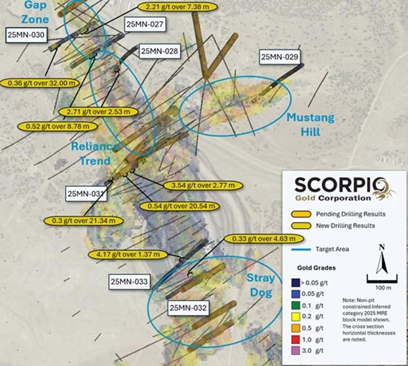
Figure 1. Surface Plan Map of Drill results over 2025 MRE Block Model.
| Drill Hole ID Final depth (m) |
Target Azimuth / Dip |
From (m) | To (m) | Intercept¹ (m) | Gold (g/t) |
| 25MN-027 | Reliance Trend | 104.85 | 108.63 | 3.78 | 0.38 |
| 377.04 | 240° / -75° | 118.41 | 123.83 | 5.41 | 0.25 |
| 131.06 | 139.84 | 8.78 | 0.52 | ||
| 25MN-028 | Reliance Trend | 153.68 | 157.52 | 3.84 | 0.25 |
| 345.64 | 240° / -72° | 289.68 | 292.21 | 2.53 | 2.71 |
| 374.84 | 382.48 | 7.64 | 0.23 | ||
| 395.22 | 398.56 | 3.34 | 0.49 | ||
| 25MN-030 | Gap Zone | 29.57 | 61.57 | 32 | 0.36 |
| 245.06 | 60° / -48° | 189.89 | 198.42 | 8.53 | 0.43 |
| 204.37 | 214 | 9.63 | 0.24 | ||
| 222.14 | 229.51 | 7.38 | 2.21 | ||
| including | 227.23 | 229.51 | 2.29 | 6.64 | |
| 25MN-031 | West Pit | 34.75 | 56.08 | 21.34 | 0.3 |
| 301.75 | 60° / -65° | 121.92 | 144.32 | 22.4 | 0.26 |
| 164.77 | 185.32 | 20.54 | 0.54 | ||
| including | 170.67 | 179.62 | 8.95 | 1.34 | |
| 205.71 | 208.48 | 2.77 | 3.54 | ||
| including | 205.71 | 206.2 | 0.49 | 14.66 | |
| 218.1 | 221.22 | 3.12 | 0.23 | ||
| 256.4 | 260.15 | 3.75 | 0.44 | ||
| 25MN-032 | West Pit | 111.65 | 117.35 | 5.7 | 0.2 |
| 290.47 | 60° / -65° | 163.56 | 168.19 | 4.63 | 0.33 |
| 25MN-033 | West Pit | 6.1 | 7.47 | 1.37 | 4.17 |
| 315.77 | 45° / -52° | 183.12 | 188.4 | 5.27 | 0.4 |
Table 1. Results from the latest batch of drill holes. There is insufficient geological information to estimate a true width for the drill intercepts reported.
Completed Hole Summaries – Reported Results
Hole 25MN-027, contained three intervals, all hosted in fine grained clastic units, of 3.78 m, 5.41 m and 8.78 m grading 0.38 g/t gold, 0.25 g/t gold and 0.52 g/t gold respectively. The first of these intervals falls within the IRCP and the latter two intercepts are located 50 m and 170 m respectively, below the IRCP.
Hole 25MN-028, contained four intervals. The uppermost interval of 3.84 m grading 0.25 g/t gold located at the base of a limestone unit, approximately at the IRCP wall. The lower three intervals, all hosted in argillites, of 2.53 m, 7.54 m and 3.34 m grading 2.71 g/t gold, 0.23 g/t gold and 0.49 g/t gold respectively, and located 80 m, 180 m and 190 m below the IRCP.
Hole 25MN-029, was an exploration drill hole testing a deep, distal structural target located between the Reliance Trend and Mustang Hill and returned no reportable intercepts.
Hole 25MN-030, was drilled in the area of the Goldwedge Mine and contained four intervals: 32 m grading 0.36 g/t gold from 29.57 m, less than 50 m behind the upper part of the IRCP; and two further intervals of 8.53 m grading 0.43 g/t gold and 9.63 m grading 0.24 g/t gold from 189.89 m and 204.37 m respectively, both in phyllites and 70-80 m below the IRCP; and 7.38 m grading 2.21 g/t gold from 222.14 m along the Reliance Trend in phyllites and approximately 100 m below the northern end of the IRCP.
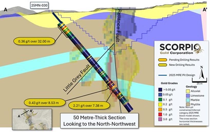
Figure 2. Section A-A, along trace of the of hole 25MN-030 showing gold grades and geology, with reported intervals highlighted, modelled structural features and trace of IRCP
Hole 25MN-031 was drilled at the northern end of the historic West Pit and contained six intervals. The upper four intervals were located within the IRCP: 21.34 m grading 0.30 g/t gold from 34.75 m within limestones; 22.40 m grading 0.26 g/t gold from 121.92 m in phyllites including 8.95 m grading 1.34 g/t gold in a splay of the Reliance Fault from 170.67 m; 2.77 m grading 3.54 g/t gold from 205.71 m, also in a splay of the Reliance Fault, hosted in phyllites. The lower two phyllite hosted intercepts of 3.12 m grading 0.23 g/t gold and 3.75 m grading 0.44 g/t gold from 218.10 m and 256.40 m respectively down hole, and 10 m and 75 m respectively below the IRCP.
Hole 25MN-032 contained two argillite hosted intervals of 5.70 m grading 0.2 g/t gold from 111.65 m, approximately 40 m to the west of the IRCP and 4.63 m grading 0.33 g/t gold from 163.56 m in a fault zone, parallel to the mapped Brougher Fault, and approximately 70 m from the bottom of the IRCP.
Hole 25MN-033, was drilled along the IRCP wall and intercepted 1.37 m grading 4.17 g/t gold from 6.10 m in a structure hosted in phyllites and 5.27 m grading 0.40 g/t gold from 187.12 m in a similar setting and located approximately 25 m below the IRCP.
Completed Hole Summaries – Assays Pending
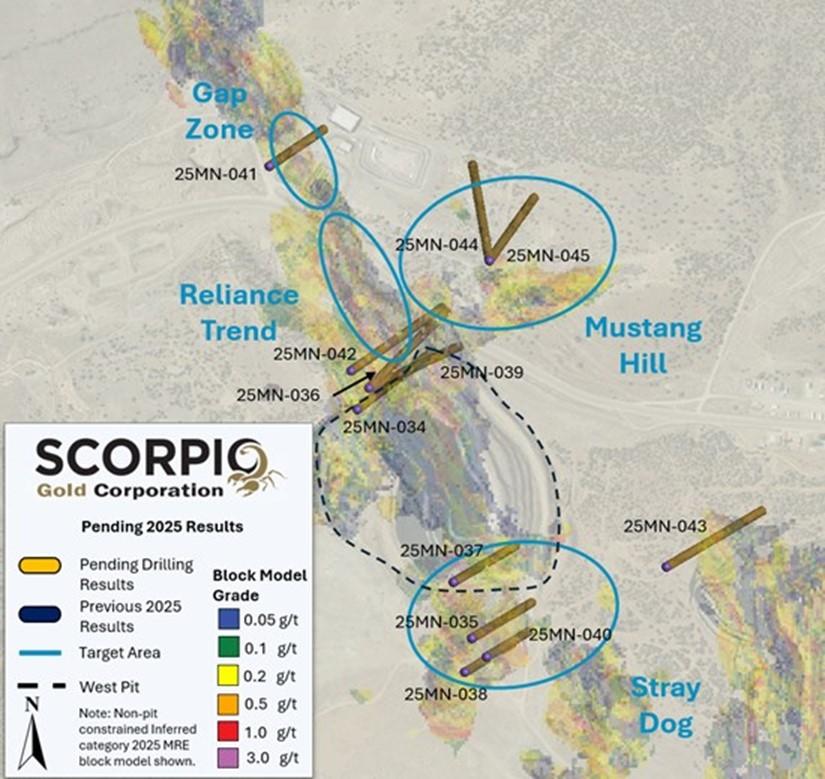
Figure 3. Location and surface traces of completed holes with assays pending, with modelled structures and Current Inferred Mineral Resource Block Model2.
25MN-034: Drilled on the Reliance Trend at the northern end of the historic West Pit, approximately 50 m to the east northeast of drill hole 25MN-031.
25MN-035: Drilled at the southern extension of the historic West Pit, within a structurally complex zone near the intersection of the Nellie Gray and Brougher Parallel Faults.
25MN-036: Drilled as a 50 m step out to the north northwest of drill hole 25MN-034 on the Reliance Trend.
25MN-037: Drilled at the southern end of the historic West Pit, approximately 80 m to the east of MN25-033 and approximately 80 m northeast of 25MN-032 in the Stray Dog target area.
25MN-038: Drilled at the southern end of the historic West Pit, within a structurally complex zone near the intersection of the Nellie Gray and Brougher Parallel Faults.
25MN-039: Drilled as a 50 m step out on drill hole MN25-036, to the north northwest, on the Reliance Trend.
25MN-040: Drilled as a 50 m step out on hole MN25-038, to the east northeast, in a structurally complex area to the south of the historic West Pit and northwest of the historic USD Pit.
25MN-041: Drilled in the Gap Zone to test the faulted contact zone between caldera volcanics and older sedimentary units that host the current Inferred Mineral Resource.
25MN-042: Drilled as a 50 m step out on drill hole MN25-039 to the north northwest, on the Reliance Trend.
25MN-043: Drilled directly north of the historic East Pit, to test for a northerly extension of a mineralized fault splay which hosted significant gold mineralization in the mined-out portions of the East Pit.
25MN-044: Drilled largely outside of the current Inferred Mineral Resource to test newly recognized gold mineralization along the faulted contact between caldera volcanics and older sedimentary units.
25MN-045: Drilled largely outside of the current Inferred Mineral Resource to test newly recognized gold mineralization along the faulted contact between caldera volcanics and older sedimentary units.
QA/QC for reported holes
HQ sized diamond drill core samples were cut in halves, then bagged and secured with security tags to ensure integrity during transportation to the Reno, NV, Paragon Geochemical facility for preparation. For quality assurance, unmarked coarse blanks, unmarked certified reference materials, and requested laboratory duplicates were inserted into the sampling sequence. QA samples were systematically inserted into each batch of samples, amounting to approximately 8% of the run of samples. Samples were analyzed for gold using method PA-AU02 (~500 g), a two-cycle PhotonAssayTM analysis of crushed material (70% passing 2 mm). All Paragon Geochemical facilities comply with ISO 17025:2017.
About the Manhattan District
Manhattan, located north of the Walker Lane Trend of Nevada, USA, is road accessible and lies approximately 20 kilometers south of the operating Round Mountain Gold Mine, which has produced more than 15 million ounces of gold.* For the first time, the Company has consolidated the project’s past-producing mines under a single entity that holds valuable permitting and water rights. Historically, Manhattan has produced approximately 700,000 ounces of gold from high-grade placer and lode operations dating from the late 1890s through to the mid-2000s.¹ The maiden mineral resource estimate covering the Goldwedge and Manhattan Pit areas of the project is comprised of 18,343,000 tonnes grading 1.26 g/t gold, for a total of 740,000 oz contained gold in the inferred category.²
A historical mineral resource estimate covers the Black Mammoth, April Fool, Hooligan, Keystone, and Jumbo areas of Manhattan and comprises 1,652,325 tonnes grading 5.89 g/t gold, for a total of 303,949 oz contained gold.**³ The deposit is interpreted as a low-sulfidation, epithermal, gold-rich system situated adjacent to the Tertiary-aged Manhattan caldera in the Southern Toquima Range of Nevada.
*Data and results from adjacent or nearby properties, including the Round Mountain Mine, are not necessarily indicative of mineralization on the Manhattan Project.
**The Company considers this historical estimate relevant, as it demonstrates the presence of significant gold mineralization across multiple zones within the district; however, its reliability is uncertain because it was prepared prior to the adoption of current CIM Definition Standards and modern QA/QC practices. The original historical estimate report provides limited disclosure of assumptions, parameters, estimation methods, cutoff grades, and QA/QC protocols, and therefore these cannot be fully verified by the Company. The categories used in the historical estimate predate, and are not directly comparable to, current CIM Definition Standards (2014), and the Company is not treating the historical estimate as a current mineral resource.
To upgrade and verify the Historical MRE to a current mineral resource, the Company would be required to undertake confirmatory drilling, modern QA/QC sampling, validation and digitization of historical datasets, and updated geological modeling followed by preparation of a new resource estimate in accordance with CIM Definition Standards and NI 43-101.
Qualified Person
The scientific and technical information in this news release has been reviewed, verified and approved by Leo Hathaway, P. Geo., Chief Geologist of Scorpio Gold, a “Qualified Person”, as defined under National Instrument 43-101 Standards of Disclosure for Mineral Projects. Verification included review of laboratory certificates, review of field logs and chain-of-custody records, inspection of blank/standard/duplicate performance, and review of collar and down-hole survey data. No limitations or failures to verify were identified.
About Scorpio Gold Corp.
Scorpio Gold holds a 100% interest in the Manhattan District located in the Walker Lane Trend of Nevada, USA. Scorpio Gold’s Manhattan District is ~4,780-hectares and comprises the advanced exploration-stage Goldwedge Mine, with a 400 ton per day maximum capacity gravity mill, and four past-producing pits that were acquired from Kinross in 2021 (see news release dated March 25, 2021). The consolidated Manhattan District presents an exciting late-stage exploration opportunity, with over 140,000 metres of historical drilling, significant resource potential, and valuable permitting and water rights.
Imperial Metals Corporation (TSX:III) reports copper and gold p... READ MORE
Aldebaran Resources Inc. (TSX-V: ALDE) (OTCQX: ADBRF) and its maj... READ MORE
Nevada Sunrise Metals Corporation (TSX-V: NEV) (OTC Pink: NVSGF)... READ MORE
Newmont Corporation (NYSE: NEM) (ASX: NEM) (PNGX: NEM) announced ... READ MORE
Scorpio Gold Corporation (TSX-V: SGN) (OTCQB: SRCRF) (FSE: RY9) i... READ MORE


