Québec Nickel Intersects 152 Metres of 0.21% Nickel + 114 ppm Cobalt at Ducros Sill

Results confirm the presence of large tonnage nickel-cobalt-bearing ultramafic intrusion with a geophysical expression spanning several hundred metres wide and seven kilometers long
Québec Nickel Corp. (CSE: QNI) (FSE: 7IB) (OTCQB: QNICF) is pleased to report drill assay results from the Ducros Sill target at its Ducros Ni-Co-Cu-PGE project, located 85 kilometers northeast of Val-d’Or, Québec.
Highlights:
- Hole QDG-23-503 was terminated at 450 metres depth in nickel + cobalt-bearing dunite, the last 118.30 metres of which returned 0.21% Ni + 117 ppm Co;
- Hole QDG-23-505 returned 293 metres at 0.19% Ni + 106 ppm Co, including a higher-grade subinterval of 152 metres @ 0.21% Ni + 114 ppm Co;
- Confirmation that the Ducros Sill is mineralized with nickel and cobalt across its entire ~300 metre width; the geophysical expression of the ultramafic body extends for seven kilometers along strike.
Ducros Sill Target
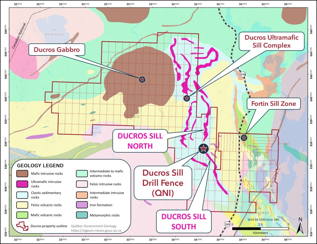
The Ducros Sill target lies at the southern half of the two-kilometer wide by fifteen-kilometer long Ducros Ultramafic Sill Complex (DUSC), in the south-central portion of QNI’s Ducros claims (Figure 1). Historically, four widely spaced holes were drilled in the immediate area by Abitibi Resources Ltd. (“Abitibi”) in 1987 (Figure 3, 4). Assessment report drill logs for the Abitibi holes describe variably serpentinized and magnetic dunitic +/- pyroxenitic rocks with occurrences of trace amounts of native copper and brucite throughout their entire drilled lengths (Quebec Government report GM 47268). Notable results include hole 87-6 which returned greater than 0.22% nickel and 120 ppm cobalt over the last 20 metres of the 106.7 metre long BQ diameter hole.
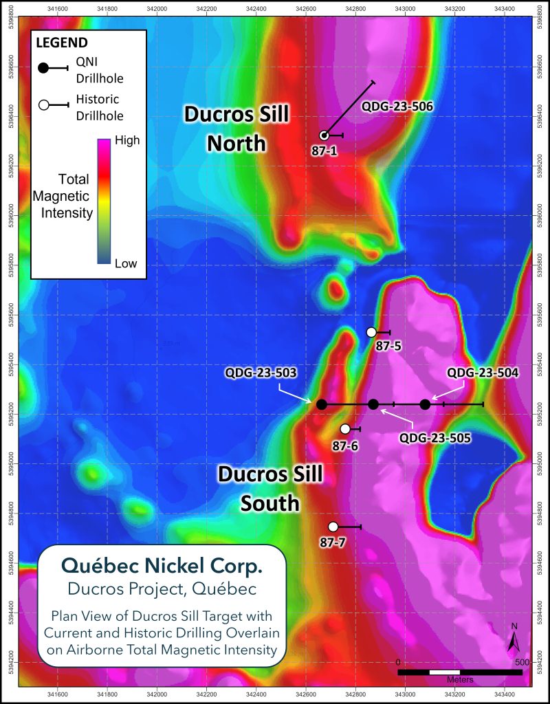
As previously announced, the Company completed a series of holes this winter along an east-west fence approximately 100 metres north of the historical Abitibi hole 87-06 (see April 19,2023 news release). The fence of holes was designed to cut across the entire 600-metre-wide magnetic high feature (Figure 2, 3). In addition to drilling this fence of holes, the Company also completed a hole approximately one kilometer north of the drill fence to test the continuity of the Ducros Sill magnetic high anomaly, hole QDG-23-506, at the very end of the winter exploration program (Figure 2, 3). All four holes completed at Ducros Sill by the Company this winter intersected long core lengths of serpentinized ultramafic rocks, including dunite, peridotite and pyroxenite units (see April 19, 2023 News Release for additional information).
Current Drilling Results
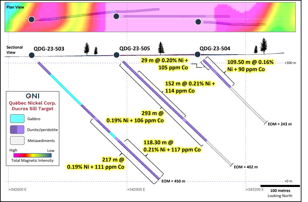
Hole QDG-23-503 was collared on the west side of the targeted magnetic high and was drilled eastward at a dip of -45°, towards the centre of the ultramafic intrusion (Figure 2). The hole encountered a package of intercalated mafic and ultramafic intrusive rocks, including gabbro, pyroxenite, peridotite and dunite, from 23.00 to 308.00 metres downhole depth before cutting a 142-metre-long interval of serpentinized dunite, believed to be the same unit encountered in Abitibi hole 87-6. The hole was terminated in this lower dunite unit until the planned end of hole of 450 metres depth. Assay results returned 0.19% Ni + 111 ppm Co over the last 217 metres of the hole (233.00-450.00 m depth) including a higher-grade subinterval of 118.30 metres @ 0.21% Ni + 117 ppm Co (308.20-426.50 m depth).
Hole QDG-23-505 was collared approximately 210 metres east of QDG-23-503 and drilled towards the east at a -45° dip to the planned end of hole depth of 402 metres (Figure 2, 3). The hole collared in variably serpentinized dunite at 21.00 metres hole depth and remained in the altered ultramafic unit until 314.00 metres, a 293-metre-long intersection, where it encountered metasedimentary footwall rocks.
Assay results for this hole returned a 293-metre-long intersection of 0.19% Ni + 106 ppm Co (21.00- 314.00 m) including a higher-grade subinterval of 0.21% Ni + 114 ppm Co over 152 metres (79.50-231.50 m).
Hole QDG-23-504 was collared approximately 210 metres east of QDG-23-505 and was also drilled towards the east at a -45° dip to a depth of 243 metres (Figure 2, 3). This hole collared in variably serpentinized dunite until 117.00 metres downhole, after which it entered the package of metasedimentary footwall rocks.
Assay results from this hole returned 109.50 metres @ 0.16% Ni + 90 ppm Co (21.00-130.50 m) including a higher-grade subinterval of 0.20% Ni + 105 ppm Co over 29 metres near surface (21.00-50.00 m hole depth).
A drill section summarizing the results from these three holes can be found as Figure 2. A summary of the assay results is found in Table 1.
Hole QDG-23-506 was collared approximately one kilometer north of the three-hole fence noted above to test the interpreted strike extension of the Ducros Sill ultramafic intrusion. This interpretation is based on the continuity of the airborne magnetic high feature identified by the 2022 VTEM™ survey as well as the lone historical hole completed by Abitibi in the immediate area (hole 87-1, Figure 3). After passing through overburden, hole QDG-23-506 collared in variably serpentinized dunite at 30.00 metres hole depth and finished in the same dunite unit at 366.00 metres. The hole was terminated earlier than planned due to the onset of spring breakup. Assays are pending for this hole, but the results are expected to be in line with those returned from QDG-23-503 through QDG-23-505.
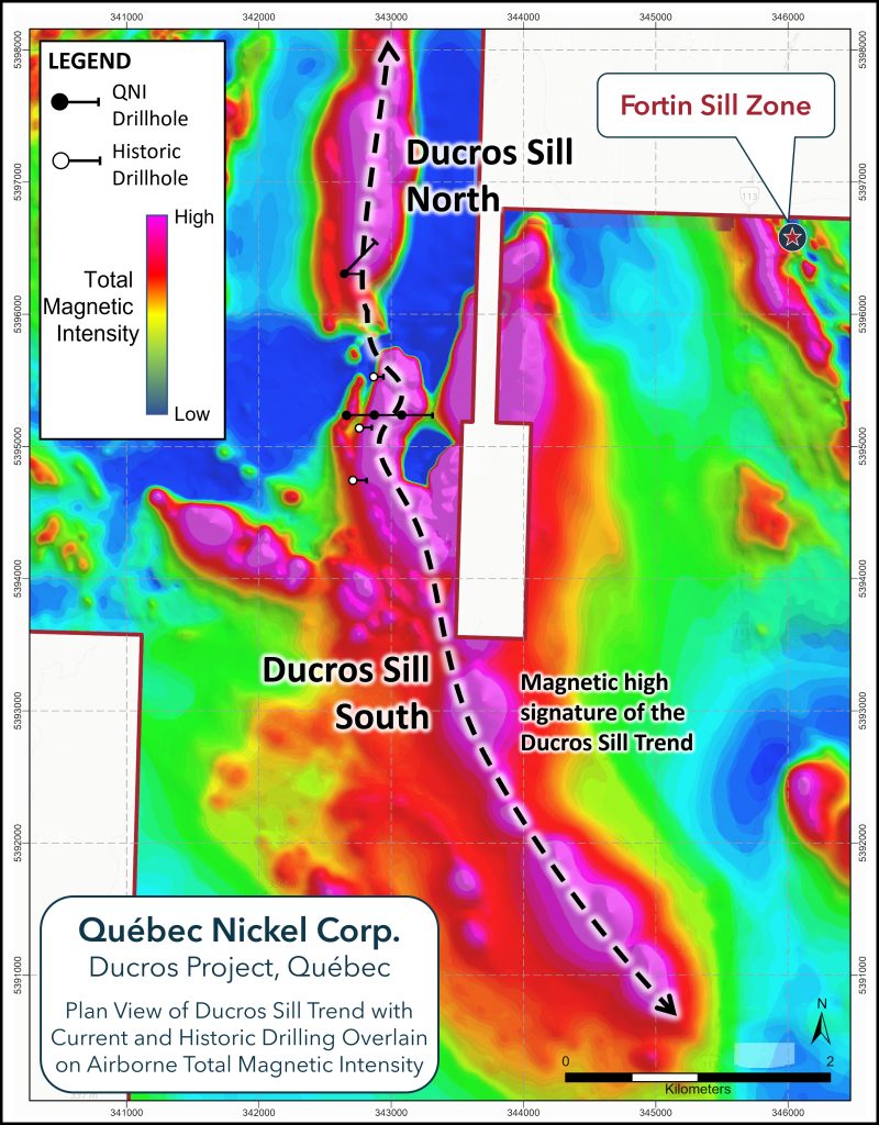
Given these results, this part of the Ducros Sill where hole QDG-23-506 was completed is now referred to as “Ducros Sill North” whereas the area which includes the recently completed three-hole drill fence is referred to as “Ducros Sill South” as shown in Figures 3 and 4.
| Hole ID | From (m) | To (m) | Length (m) | Ni (%) | Co (ppm) |
| QDG-23-503 | 233.00 | 450.00 | 217.00 | 0.19 | 111 |
| including | 308.20 | 426.50 | 118.30 | 0.21 | 117 |
| QDG-23-504 | 21.00 | 130.50 | 109.50 | 0.16 | 90 |
| including | 21.00 | 50.00 | 29.00 | 0.20 | 105 |
| QDG-23-505 | 21.00 | 314.00 | 293.00 | 0.19 | 106 |
| including | 79.50 | 231.50 | 152.00 | 0.21 | 114 |
| QDG-23-506 | Assays pending | ||||
Table 1. Summary of assay results for holes QDG-23-503 through QDG-23-505. Reported results are sample length weighted.
Extents of the Ducros Sill Intrusion
The digital Québec government geology for QNI’s Ducros Project claims, as sourced from the SIGEOM database, combined with these recent results indicates the Ducros Sill ultramafic intrusion now spans two kilometres north of QNI’s most recent drilling, as confirmed by hole QDG-23-506, to approximately five kilometers to the south-southeast (Figure 1, 4). There is no evidence of this magnetic high feature being exposed at surface or drilled beyond the recent work conducted by QNI and Abitibi Resources Ltd. in 1987. Should this seven-kilometer-long magnetic anomaly be the geophysical expression of the Ducros Sill intrusion, as is currently hypothesized, its overall dimensions would rival the size of other high-profile large tonnage nickel-cobalt projects currently being advanced in the Abitibi Greenstone Belt.
Fortin Sill Zone Work Update
During the first part of the year, exploration drilling focused exclusively on testing targets that require winter conditions to access, such as at the Ducros Ultramafic Sill Complex and Ducros Gabbro targets (Figure 1). The Company intends to resume exploration at the Fortin Sill Zone, where local ground conditions allow for year-round access, once the forest fire-related work restrictions are lifted. Drilling at the Fortin Sill Zone this summer and fall will follow up on some of the exceptional results returned in 2022, including from hole QDG-22-29, which drilled an 11.80 metre interval containing 1.44% Ni, 1.49% Cu, 461 ppm Co and 2.79 g/t Pt-Pd-Au that includes a higher-grade subinterval assaying 1.85% Ni, 1.65% Cu (3.50% Ni + Cu), 576 ppm Co and 3.27 g/t Pt-Pd-Au over 8.43 metres (see August 30, 2022 News Release for reference).
Core Processing & QAQC
Québec Nickel has implemented a quality assurance and quality control (“QAQC”) program for its drilling programs to ensure best practices for logging, sampling and analysis of its drill core as well as for the collection and analyses of rock samples. This includes the regular insertion of geochemical blanks, sample duplicates and multiple Ni-Cu-PGE-Au certified reference material standards (CRMs) into the sample stream.
Drill core is collected by Ducros Project personnel daily from the drill rigs and transported in secured core boxes to QNI’s core logging facilities in Lebel-sur-Quévillon. Logging is completed on laptops and data are captured using fit-for-purpose computer software.
Core destined for geochemical analyses is identified and labeled by core logging geologists and is then sawed in half by a diamond blade. One half of the NQ-diameter core sample is placed in a labeled and secured sample bag. The remaining half of the core sample is returned to its core box for archiving. All core samples are transported from QNI’s logging facilities to AGAT Laboratories’ and/or SGS Canada’s sample preparation facilities in Val-d’Or in secured and numbered rice bags by Project personnel.
AGAT Laboratories and SGS operate under a Quality Management System that complies with the ISO/IEC 17025:2017 standard. Analysis for precious metals (gold, platinum, and palladium) is completed by Fire Assay with an ICP-OES finish while analyses for nickel, copper and 41 other elements are performed using AGAT’s and SGS’s 4 Acid Digest – Metals Packages, with an ICP-OES finish.
QUALIFIED PERSON
Gary DeSchutter, M.Sc., P.Geo., Vice-President of Exploration for Québec Nickel Corp., and a Qualified Person as defined under National Instrument 43-101 (“NI 43-101”), has reviewed, and approved the scientific and technical content of this press release.
ABOUT QUEBEC NICKEL CORP.
Québec Nickel Corp. is a mineral exploration company focused on acquiring, exploring, and developing critical metals (Ni-Cu-Co-PGE) projects in Québec, Canada. The Company has a 100% interest in the Ducros Property, consisting of 282 contiguous mining claims covering 15,293 hectares within the eastern portion of the Abitibi Greenstone Belt in Québec, Canada.

Figure 1. Geology map of Québec Nickel’s Ducros property (red outline) showing the individual mining claims that comprise the Ducros property land package, along with the locations of the Ni-Co-Cu-PGE target areas. The regional geology is sourced from the Government of Québec’s online SIGEOM database. (Graphic: Business Wire)

Figure 2. Drill section of the Ducros Sill target drill fence showing the summary assay results for holes QDG-23-503 through QDG-23-505. Magnetic data derived from combined VTEMTMand drone data collected in 2022. Section is looking north. (Graphic: Business Wire)

Figure 3. Plan map of the Ducros Sill target area showing the locations of the historic Abitibi Resources Ltd. drill holes (white symbols) and the recently completed QNI drill holes (black symbols) overlain on the total magnetic intensity image as derived from the compiled/combined VTEMTM and drone magnetic surveys completed in 2022. (Graphic: Business Wire)

Figure 4. Plan map of the Ducros Sill target area showing the locations of the historic Abitibi Resources Ltd. drill holes (white symbols) and the recently completed QNI drill holes (black symbols) overlain on the total magnetic intensity image derived from the compiled/combined VTEMTM and drone magnetic surveys completed in 2022. The multi-kilometer Ducros Sill Trend is indicated by the dashed line. (Graphic: Business Wire)
MORE or "UNCATEGORIZED"
Aldebaran Announces Closing of $40 Million Bought Deal Offering
Aldebaran Resources Inc. (TSX-V: ALDE) (OTCQX: ADBRF) is please... READ MORE
Erdene Announces Closing of $25 Million Bought Deal Private Placement
Erdene Resource Development Corp. (TSX:ERD) (MSE:ERDN) (OTCQX: ER... READ MORE
NOVAGOLD Announces Closing of Upsized Bought Deal for Gross Proceeds of US$310 Million
NOVAGOLD RESOURCES INC. (NYSE: NG) (TSX: NG) is pleased to report... READ MORE
Guanajuato Silver Sees Significant Growth in Resources at Valenciana
~ Inferred Mineral Resources Increased by 630% to 20.3M AgEq Ounc... READ MORE
Copper Quest Increases and Closes Unit Offering for Total Gross Proceeds of $2,099,890
Copper Quest Exploration Inc. (CSE: CQX) (OTCQB: IMIMF) (FRA: 3MX... READ MORE


