








Outcrop Silver & Gold Corporation (TSX-V: OCG) (OTCQX: OCGSF) (DE: MRG1) is pleased to announce the results of nine core holes designed to test the continuity at depth of the Las Maras shoot on its 100% owned Santa Ana high-grade silver project in Colombia. Twenty-three holes have been drilled in Las Maras to date. Thirteen returned high-grade assays; two holes have assays that are pending.
Las Peñas vein in Las Maras shoot has an average estimated true width of 1.6 metres with a weighted average grade of 1,161 grams equivalent silver per tonne. Significantly, recent drilling extends Las Maras shoot to 370 metres depth, the deepest high-grade mineralization drilled to date on Santa Ana project. This compares to an average drill depth of only 170 metres on twelve other ore shoots. Potential resource areas may be more than doubled by relatively low-risk deeper drilling offsetting known shallower high-grade mineralization. Importantly, the limit to high-grade mineralization at depth within the Santa Ana vein systems is open.
Highlights
“We are thrilled with our most recent drill results at Las Maras with very robust vein interceptions extending high grade,” comments Guillermo Hernandez, Vice President of Exploration. “The deeper Las Maras delineation program shows encouraging visual results of abundant silver sulfide in core pending assays, which suggests high-grade mineralization will continue at depth.”
“Las Maras results are encouraging in the context of our year-end compliant resource,” comments Joseph Hebert, Chief Executive Officer. “With an average vein true thickness of 1.6 metres that compares to the possible use of engineered “long hole stopes” of 1.5 metres in the resource report, external dilution of the Las Maras veins that have a weighted average grade of 1,162 grams silver equivalent per tonne, may substantially be controlled. The depth of mineralization drilled in Las Maras indicates potential to expand all shoots in the resource area up to 117 percent by volume with just deeper drilling, which will be completed early in 2023.”
| Target | Hole ID | From (m) |
To
(m) |
Width (m)* |
Au g/t | Ag g/t | Pb % | Zn % | AgEq g/t |
| Las
Maras |
SAMR22DH286 | NSR | |||||||
| SAMR22DH288 | NSR | ||||||||
| SAMR22DH290 | 265.00 | 265.45 | 0.25 | 0.65 | 264 | 0.06 | 0.02 | 292 | |
| SAMR22DH292 | 268.58 | 274.80 | 4.40 | 1.64 | 442 | 0.43 | 0.49 | 563 | |
| including | 268.58 | 269.15 | 0.40 | 16.59 | 3,807 | 4.43 | 5.15 | 5,109 | |
| and | 274.27 | 274.80 | 0.37 | 0.45 | 890 | 0.13 | 0.12 | 846 | |
| SAMR22DH294 | 209.70 | 212.06 | 2.14 | 2.00 | 2,054 | 0.30 | 0.33 | 2,032 | |
| including | 209.70 | 210.23 | 0.48 | 0.54 | 1,253 | 0.22 | 0.16 | 1,184 | |
| and | 210.23 | 211.01 | 0.71 | 5.50 | 5,289 | 0.72 | 0.76 | 5,254 | |
| including | 216.10 | 216.40 | 0.23 | 4.53 | 1,715 | 4.08 | 0.53 | 2,038 | |
| and | 217.00 | 217.30 | 0.23 | 30.49 | 3,737 | 1.75 | 1.38 | 5,912 | |
| SAMR22DH294 | 226.03 | 226.32 | 0.22 | 3.55 | 2,209 | 1.72 | 0.98 | 2,363 | |
| SAMR22DH297 | 249.01 | 252.20 | 1.46 | 4.76 | 1,941 | 1.15 | 1.42 | 2,224 | |
| including | 249.01 | 250.27 | 0.56 | 2.78 | 1,496 | 0.47 | 0.83 | 1,620 | |
| and | 251.08 | 252.20 | 0.47 | 10.35 | 3,806 | 2.72 | 3.08 | 4,468 | |
| SAMR22DH297 | 263.30 | 265.10 | 0.79 | 1.06 | 277 | 0.14 | 0.48 | 360 | |
| including | 264.20 | 265.10 | 0.40 | 1.74 | 514 | 0.27 | 0.96 | 653 | |
| SAMR22DH297 | 307.19 | 307.49 | 0.15 | 1.44 | 557 | 0.09 | 0.16 | 626 | |
| SAMR22DH299 | NSR | ||||||||
| SAMR22DH300 | 307.19 | 307.49 | 3.82 | 0.87 | 504 | 0.19 | 0.21 | 537 | |
| including | 285.86 | 286.98 | 0.52 | 1.64 | 2,137 | 0.51 | 0.85 | 2,102 | |
| and | 291.58 | 292.27 | 0.32 | 5.94 | 2,334 | 1.28 | 0.85 | 2,642 | |
| *Estimated True width. Metal prices used for equivalent calculations were US$1,827/oz for gold, US$21.24/oz for silver, US$0.90/lb for lead and US$1.56/lb for zinc. Metallurgical recoveries assumed are 93% for gold, 90% for silver, 90% for lead and 92% for zinc. NSR: No significant result. | |||||||||
| Table 1. New significant drill assays from Las Maras. | |||||||||
Twenty-three drill holes have been completed in Las Maras to date; thirteen returned high-grade assays; two holes have assays pending (Figure 4). The drill program at Las Maras continues with additional delineation holes to offset DH301 and DH302 at depth. Both of these drill holes show silver-sulfide mineralogy in core (Figure 3 and Figure 4).
Las Maras comprises two, northerly trending parallel veins, and the main northeast-trending Las Peñas vein (Map 1). Las Peñas vein shows wide alteration halos with quartz stringers and fault gouge. All three veins show continuity and may contribute to the planned compliant resource to be published in 2022.
| Hole ID | Easting | Northing | Elevation (m) |
Depth (m) | Azimuth | Dip |
| SAMR22DH282 | 505849.526 | 564165.154 | 890.613 | 209.09 | 138 | -65 |
| SAMR22DH286 | 505850.365 | 564163.735 | 891.026 | 206.10 | 160 | -49 |
| SAMR22DH288 | 505850.365 | 564163.735 | 891.026 | 215.64 | 160 | -58 |
| SAMR22DH290 | 505805.758 | 564211.332 | 903.472 | 284.80 | 136 | -60 |
| SAMR22DH292 | 505810.871 | 564291.112 | 923.254 | 330.09 | 130 | -60 |
| SAMR22DH294 | 505815.642 | 564244.261 | 901.981 | 282.65 | 130 | -61 |
| SAMR22DH297 | 505815.642 | 564244.261 | 901.981 | 337.10 | 130 | -67 |
| SAMR22DH299 | 505814.389 | 564243.887 | 901.925 | 366.36 | 130 | -77 |
| SAMR22DH300 | 505815.221 | 564244.958 | 901.902 | 309.98 | 110 | -70 |
| Table 2. Collar and survey table for drill holes reporting in this release. | ||||||
QA/QC
Core samples are sent to either Actlabs in Medellin or ALS Chemex in Medellin for preparation and then to ALS Chemex in Toronto or Lima, Peru, for analysis. In line with QA/QC best practice, approximately three control samples are inserted per twenty samples (one blank, one standard and one field duplicate). The samples are analysed for gold using a standard fire-assay on a 50-gram sample with a gravimetric finish. Multi-element geochemistry is determined by ICP-MS using either aqua regia (ME-MS41) or four-acid (ME-MS61) digestion. Comparison to control samples and their standard deviations indicates acceptable accuracy of the assays and no detectible contamination.
About Santa Ana
The 100% owned Santa Ana project comprises 36,000 hectares located in the northern Tolima Department, Colombia, 190 kilometres from Bogota. The project consists of five or more regional scale parallel vein systems across a trend 12 kilometres wide and 30 kilometres long. The Santa Ana project covers a majority of the Mariquita District, where mining records date to at least 1585. The Mariquita District is the highest-grade primary silver district in Colombia, with historic silver grades reported to be among the highest in Latin America from dozens of mines. Historic mining depths support a geologic and exploration model for composite mesothermal and epithermal vein systems having mineralization that likely extends to great depth. At Santa Ana, it is unlikely that there is sharp elevation restriction common to high-grade zones in many epithermal systems with no mesozonal component. The extremely high silver and gold values on Santa Ana reflect at least three recognized overprinting mineralization events.
At the core Royal Santa Ana project, located at the northern extent of just one of the regional vein systems controlled by Outcrop, thirteen high-grade shoots have been discovered to date – La Ivana hanging-wall and footwall (La Porfia vein system); San Antonio, Roberto Tovar, San Juan (Royal Santa Ana vein systems); Las Maras (Las Penas vein system); El Dorado, La Abeja (El Dorado vein systems); Megapozo, Paraiso (El Paraiso vein system); Espiritu Santo (Aguilar vein system); La Isabela and Los Naranjos. Each zone commonly contains multiple parallel veins. The veins can show both high-grade silver and high-grade gold mineralization, and low-angle veins appear to connect to more common high-angle veins.
Outcrop drilling indicates that mineralization extends from surface or near surface to depths of at least 370 metres. Cumulatively, over 60 kilometres of mapped and inferred vein zones occur on the Santa Ana project. The Frias Mine on the south-central part of the project, 16 kilometres south of the Royal Santa Ana Mines, produced 7.8 million ounces of silver post-production in the Spanish colonial era at a recovered grade of 1.3 kg Ag/t. The Frias Mine is considered an analogue to each of the thirteen shoots discovered to date by Outcrop. Between the Royal Santa Ana Mines and the Frias Mine, veins have been extended to the south providing strong drill targets in the Aguilar, Espiritu Santo and El Cristo veins that show high values up to 5.5 kg AgEq/t. These veins show widths up to 4.7 metres. Twelve kilometres of vein zones have been mapped between El Dorado vein to the north and the Aguilar vein to the south. An additional seven kilometres of veins have been mapped between Aguiler and the Frias mine, including the veins Los Mangos and La Ye, which provide several targets with high values up to 9,738 g AgEq/t.
About Outcrop
Outcrop Silver & Gold is rapidly advancing the Santa Ana high-grade silver discovery with ongoing expansion drilling and an initial resource to be released in the coming months. Outcrop is also progressing exploration on four gold projects with world-class discovery potential in Colombia. These assets are being advanced by a highly disciplined and seasoned professional team with decades of experience in Colombia.
Qualified Person
The technical information in this news release has been approved by Joseph P Hebert, a qualified person as defined in NI43-101 and President and Chief Executive Officer of Outcrop Silver.
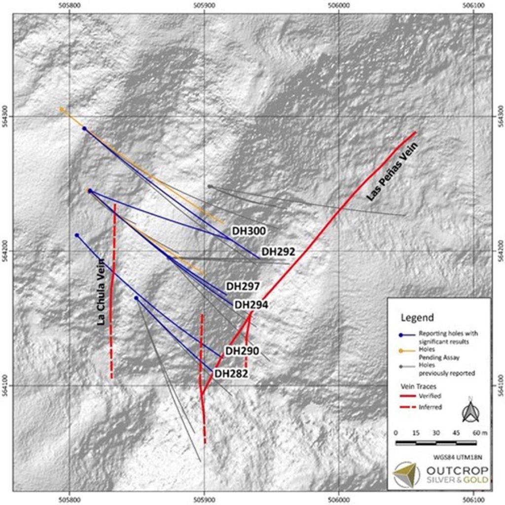
Map 1. Las Maras target area with drill hole traces. (CNW Group/Outcrop Silver & Gold Corporation)
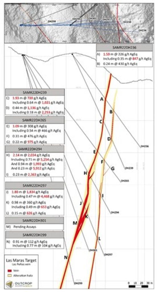
Figure 1. Cross section of Las Maras. (CNW Group/Outcrop Silver & Gold Corporation)
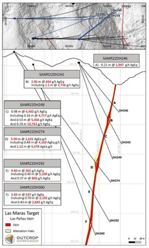
Figure 2. Cross section of Las Maras. (CNW Group/Outcrop Silver & Gold Corporation)
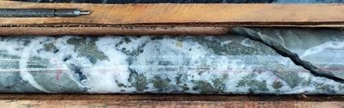
Figure 3. Drill core pending assay from hole DH301 at 299 m shows strong mineralization Las Peñas vein. (CNW Group/Outcrop Silver & Gold Corporation)
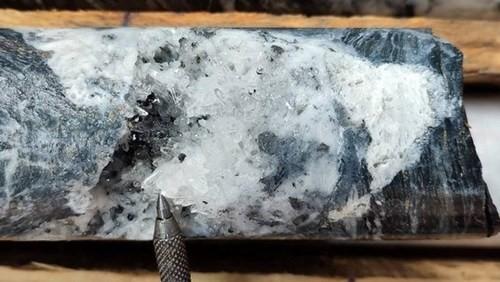
Figure 4. Drill core pending assay from hole DH302 at 353 m shows silver-sulfide mineralization from Las Peñas vein. (CNW Group/Outcrop Silver & Gold Corporation)
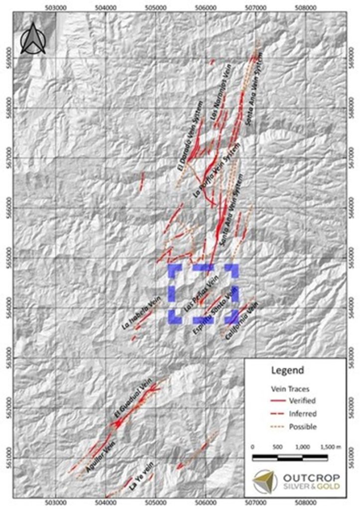
Map 2. Location of Las Peñas vein at Las Maras, 3 km south of the Royal Santa Ana vein system and 2 kilometres north-east from the Aguilar-Guadual vein system. Detailed work will probably show continuity between these vein zones. (CNW Group/Outcrop Silver & Gold Corporation)
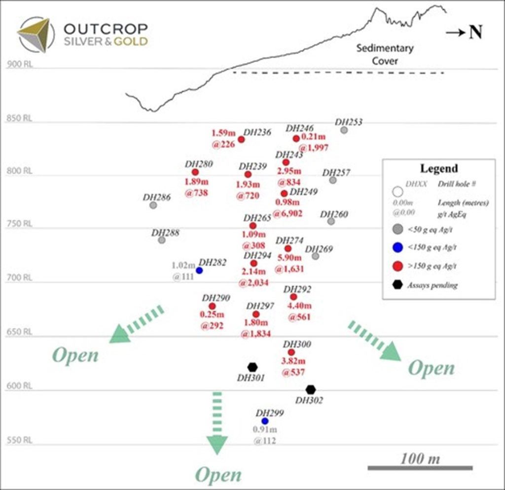
Figure 5. Longitudinal section from Las Peñas vein with estimated true width in drill pierce points. (CNW Group/Outcrop Silver & Gold Corporation)
Critical Metals Corp. (Nasdaq: CRML) a leading critical minerals ... READ MORE
Holes SH26-22 and SH26-23 return up to 930 g/t AgEq within broade... READ MORE
Pasinex Resources Limited (CSE: PSE) (FSE: PNX) a growing zinc-fo... READ MORE
Aya Gold & Silver Inc. (TSX: AYA; NASDAQ: AYA) is pleased to... READ MORE
New Break Resources Ltd. (CSE: NBRK) (OTCQB: NBRKF) (FSE: O91) ha... READ MORE


