


Highlights:
Northisle Copper and Gold Inc. (TSX-V: NCX) is pleased to announce that it has received the first assay results from its 2021 drill program at Northwest Expo confirming a zone of high-grade, gold-rich porphyry mineralization approximately 3 kilometers northwest of its Red Dog Deposit. In addition, preliminary surface geophysical surveys at Macintosh have identified numerous chargeability and resistivity anomalies. Northisle commenced drill testing these anomalies on January 19, 2022 and anticipates completion during Q1 2022. In addition, Northisle recently completed 4 holes at Hushamu, and will continue in-fill and step-out drilling following completion of drilling at Macintosh.
Sam Lee, President & CEO of Northisle stated “We are pleased with the results at Northwest Expo to date which demonstrates the potential to add higher grade resources to the North Island Project. This gold-rich zone is not within the current resource at the North Island Project and is only 14 kilometers from the proposed plant site. Grades in the new zone are approximately three to five times higher than the grades at Hushamu and Red Dog which could have a positive impact on project economics and support our belief that we are just scratching the surface of the potential of our 50km camp scale porphyry belt.”
Robin Tolbert, Vice President Exploration of Northisle added “With the receipt of assay results from NW21-03, we have now defined an area of approximately 480 meters by 360 meters of porphyry copper-gold mineralization, with an interpreted average width of 86 meters, and this volume is open in multiple directions. This is just the beginning of exploration on Northwest Expo. A ground-based geophysical program is scheduled to commence shortly and will allow targeting of an expanded drill program, to commence upon receipt of permits. The positive assay results have confirmed the regional interpretation of the importance of the chlorite-magnetite mineralization in this area, which will help to inform our approach to exploring the rest of our large and prospective land package.” He added, “I am very excited to get back in the field during Q1 to test the drill targets identified by recent geophysical surveys at Macintosh and continue to see immense opportunities across our more than 33,000 hectares of exploration tenure.”
Summary of High-Grade Gold Rich Porphyry Zone Results
Intercepts of the high-grade gold zone are summarized in Table 1.
| Table 1: Zone 1 Significant Intercepts | |||||||||
| Hole ID | From (m) |
To (m) | Interval (m) |
True Width (m) |
Au Grade (g/t) |
Cu Grade (%) |
Mo Grade (%) |
Re Grade (g/t) |
Au Eq. Grade (g/t) |
| NW21-03 | 280.25 | 365.05 | 84.8 | 84.0 | 0.92 | 0.19 | 0.005 | 0.17 | 1.20 |
| Including | 280.3 | 305.0 | 24.8 | 24.8 | 1.30 | 0.10 | 0.007 | 0.30 | 1.46 |
| EC-218 | 323.8 | 438 | 114.2 | 114.0 | 0.53 | 0.11 | 0.004 | * | 0.70 |
| EC-228 | 151.85 | 221.9 | 70.1 | 70.0 | 1.15 | 0.22 | 0.018 | * | 1.52 |
| EC-233 | 329.2 | 423.7 | 94.5 | 94.0 | 0.86 | 0.13 | 0.002 | * | 1.04 |
| EC-234 | 286.5 | 384.0 | 97.5 | 97.5 | 0.94 | 0.16 | 0.003 | * | 1.18 |
| EC-245 | 148.0 | 264.9 | 116.9 | 110.0 | 1.18 | 0.15 | 0.001 | * | 1.80 |
| Including | 234.7 | 264.9 | 30.2 | 28.4 | 2.03 | 0.25 | 0.001 | * | 2.37 |
| EC08-254 | 270.00 | 386.00 | 116.0 | 95.0 | 1.00 | 0.17 | 0.005 | 0.37 | 1.26 |
| Including | 322.0 | 352.0 | 30.0 | 24.6 | 1.50 | 0.21 | 0.008 | 0.24 | 1.82 |
* Not analyzed in historical drilling.
Bolded holes are from 2021 drilling
Copper and gold equivalent calculations based on the following metal prices which were used in the Company’s 2021 PEA on the North Island Project:
Cu = US$3.25/lb, Au = US$1,650/oz, Mo = US$10/lb, Re = $1,256/kg. Calculations assume 100% recovery; totals may not add due to rounding
Note on equivalent calculation:
Copper equivalent is determined by calculating total contained metal value/ tonne, dividing by the copper price, and then dividing the resultant number of pounds of copper by 2204.6. Gold equivalent is determined by calculating total contained metal value/tonne, dividing by the gold price, and then multiplying the resultant number of troy ounces of gold by 31.103
Figure 1 can be found at full size at the following link:
http://www.northisle.ca/wp-content/uploads/2022/01/Figure-1-Northisle-Project-Location-220113.pdf
Northwest Expo Details
Northwest Expo has been the subject of several drill programs dating back to at least 2005. Current exploration is focused on gaining a better understanding of three zones, labelled Zone 1, Zone 2, and Zone 3. Zone 1 contains significant intercepts of gold-rich copper porphyry mineralization and is a compelling target for near-term exploration. Zone 2 exhibits extensive faulting and may represent a down faulted block. Zone 3 contains historic drill intercepts of significant (>0.1 % Cu) copper-gold porphyry mineralization from 91 metres to 176 metres in length. Two holes were drilled in 2021 in this area with assays pending.
The objective of the 2021 program at Northwest Expo was to drill test anomalies indicated by limited induced polarization (IP) geophysical surveys completed in 2012. A review of historical drilling from 2005 and 2007, and updated with additional data from 2008, identified several intercepts of economically significant gold and copper which are detailed below. Figure 2: Northwest Expo Zones and shows the location of 2021 drilling at Northwest Expo in the context of historical drilling. The previous IP geophysics identified a 550 m wide chargeability anomaly (>15mV/V) extending south from a line running northeast from 5619500 North (north of DDH EC245) to 571400 East (northeast of DDH NW21-02). This anomaly is open to the northeast. The IP/Mag survey planned to commence in Q2 2022 will cover that un-surveyed area.
To date, assays for NW21-03 and NW21-04 have been received. NW21-03 is detailed, along with nearby historical drill holes in Zone 1, in Table 1. NW21-04 had no significant intercepts but provided a better understanding of Zone 2. NW21-05 and NW21-08 (assays pending) are also assigned to Northwest Expo Zone 2, while NW21-01 and NW21-02 are targeting an un-drilled area of Zone 3.
The observed styles of alteration and mineralization in drill holes at Northwest Expo are consistent with the current hypothesis that this porphyry system is tilted to the southwest so that the core of the porphyry system lies to the northeast.
A plan view Northwest Expo, showing the above drill holes, can be found in Figure 2.
Figure 2 can be found at full size at the following link:
http://www.northisle.ca/wp-content/uploads/2022/01/Figure-2-Zone-1-3-V8.pdf
Collar data for the relevant drill holes in Zones 1, 2 and 3 can be found on the Company’s website here.
Figure 3 can be found at full size at the following link:
http://www.northisle.ca/wp-content/uploads/2022/01/Figure-3.jpg
Zone 1 – Gold-rich Porphyry Target
This zone is underlain by Jurassic Bonanza Formation andesitic volcaniclastics, flows and feldspar porphyry dykes and minor diorite with intense silica-clay-pyrite alteration imposed upon them, as well as hydrothermal breccias and silica immiscibility textured rocks emanating from an aerially extensive hydrothermal system. Mineralization occurs predominantly in characteristic chlorite-magnetite altered rocks (CMG) which is identical to the mineralization observed at Island Copper, Hushamu, Red Dog and Goodspeed areas.
Figure 4 shows the location of current and historical drill holes in Zone 1, including significant intercepts (> 0.1% Cu) of drilling to date as well as the location of two cross-sections detailed in Figure 5 (Section A-A’) and Figure 6 (Section B-B’). Table 1 details the grades of those intercepts.
Drill hole NW21-03 is of particular interest as it confirms a zone of high-grade gold-copper porphyry mineralization which extends from EC-254 in the west approximately 480 meters horizontally to NW21-03 in the east, and from EC-254 in the north 120 metres horizontally to EC-228 in the south, for an interpreted total extent of at least 500 meters strike length by between at least 240 – 480 metres dip length (Sections A-A’ and B-B’ in Figure 5 and Figure 6 respectively). Drill holes which intersect this zone have significant mineralized intercepts (>0.1% Cu) ranging from 70 metres to 116 m in length, and an interpreted average true width of 86 metres.
Figure 4 can be found at full size at the following link:
http://www.northisle.ca/wp-content/uploads/2022/01/Figure-4-Zone-1-V5.pdf
It was observed in several historic holes and in NW21-03 assays that a zone with higher molybdenum and rhenium grades occurs above and overlaps with the intercepts noted in Table 1. None of the 2005-2007 holes were analyzed for rhenium. Northisle plans to carry out check re-assays of those holes for Cu, Au, Mo and Re.
Figure 5 can be found at full size at the following link:
http://www.northisle.ca/wp-content/uploads/2022/01/Figure-5-Section-A-A-V7.pdf
Figure 6 can be found at full size at the following link:
http://www.northisle.ca/wp-content/uploads/2022/01/Figure-6-Section-2-B-B-V7.pdf
Other Exploration Programs
Macintosh IP Survey and Drill Program
Simcoe Geoscience Limited completed over 13,500 metres of magnetometer and IP geophysical surveys on 5 lines across the intensely silica-clay-pyrite (SCP) altered Macintosh target immediately adjacent and southeast of the Hushamu Deposit (Figure 7 and Figure 8). Macintosh has similar geology to the Hushamu Deposit in that it is underlain by Jurassic Bonanza Formation, predominantly andesitic volcaniclastics and flows intruded by feldspar porphyry dykes and diorite from the Northeast.
Figure 7 can be found at full size at the following link:
http://www.northisle.ca/wp-content/uploads/2022/01/Figure-7.jpg
The surveys identified two main IP chargeability anomalies which extend to over 400 metres depth, with branches approaching near surface, and trend across MacIntosh Mountain over 2,000 m from northeast to southwest and over 2,700 m from northwest to southeast (Figure 7 and Figure 8). These anomalies are open at depth and to the northeast and southwest. The northwest anomaly to be tested by proposed holes PH-6 and PH-7 (Figure 8) is adjacent and contiguous with the Hushamu Deposit. The central anomaly and branches will be tested by PH-1 to 5 and Ph-8 and PH-A. This central anomaly has coincident magnetic anomalies at depth and to the northeast. One of the main ore types at Hushamu, Northwest Expo and Red Dog is chlorite-magnetite altered Bonanza Formation and is, as the name suggests, very magnetic. These proposed holes will also test these magnetic anomalies.
Figure 8 can be found at full size at the following link:
http://www.northisle.ca/wp-content/uploads/2022/01/Figure-8.png
Nine drill holes are planned to test these anomalies. The first drill hole (MT22-01), shown as PH-1 above, has commenced at the time of this press release.
2022 Surface Geophysical Surveys
Simcoe will resume geophysical surveying on the remaining four regional targets Northwest Expo, Red Dog, Goodspeed, and Pemberton Hills once snow clears from these areas. This program is anticipated to be complete in Q3 2022.
Hushamu
Four planned drill holes at Hushamu have now been completed, totalling 2,162 metres. Drilling at Hushamu was paused to allow the drill to test the targets at Macintosh, as described above. The holes completed during late 2021 and early 2022 were targeted at filling in an under-drilled volume to the southwest of the resource and intercepted mineralization consistent with that found elsewhere in the Hushamu Deposit. The objective of the recently completed drilling was to test areas near the defined resource with potential for increasing the global resource. Additional drilling at Hushamu will commence following completion of exploratory drilling at Macintosh.
Red Dog
At Red Dog, drill hole RD21-01 was targeted to test silica-clay-pyrite (SCP) alteration at depth to the south of a major east-west trending fault zone and to drill through the fault and underneath the Red Dog Deposit which consists of a mineralized silica-magnetite breccia. The objective was to find the source porphyry for this mineralization. This drill hole encountered SCP alteration but no mineralized intervals on either side of the fault. RD21-02 was drilled to test an IP chargeability anomaly northwest of the Red Dog Deposit. The anomaly was found to be caused by SCP and propylitic alteration occurring from near surface to over 300 m depth in the hole. The hole ended in late basalt and felspar-porphyry dykes. Assay results for holes RD21-01 and RD21-02 have now been received and although have no significant assays the lithologies encountered confirm the existence of a very large area of alteration consistent with an extensive hydrothermal system with anomalous copper in soils. Future drilling will be undertaking following completion of the geophysical survey described above.
Key Exploration Catalysts
Key exploration catalysts for the coming year are detailed in Table 2:
| Table 2: Key Exploration Catalysts | ||
| Timing | Category | Details |
| Q1 2022 | Assays | Northwest Expo, Hushamu Assays |
| Q1-Q2 2022 | Surface Exploration | Surface exploration at Northwest Expo, Pemberton Hills |
| Q2 2022 | Drilling | Preliminary assays from Macintosh drilling |
| Q2 2022 | Surface Exploration | Surface exploration at Goodspeed, Red Dog |
| H2 2022 | Drilling | Drill Program at Northwest Expo, Macintosh |
| Through H2 2022 | Drilling | Continue Hushamu in-fill and step out drilling |
Additional 2022 exploration programs will follow the above activities.
Logging, Sampling and Assaying Procedures
The diamond drill core logging and sampling program was carried out under a rigorous quality assurance / quality control program using industry best practices. Drill intersections in this release are typically HQ to 100 m and NQ thereafter to the end of holes. After drilling, core was logged for geology, structure, and geotechnical characteristics utilizing Geospark© core logging software, then marked for sampling and photographed on site. The cores for analyses were marked for sampling based on geological intervals with individual samples 3 m or less in length. Drill core was cut lengthwise in half with a core saw. Half-core was sent for assays reported in this news release. Prior to cutting core for assay bulk density was also determined on site by taking 20 to 25 cm lengths of whole core of each lithology at 10 m intervals. The ends of these were then cut at right angle to the core axis, retaining all pieces to be returned to the core box for later sample cutting and analysis. The diameter of each core sampled for bulk density was measured at each end with digital calipers to 3 decimal places and recorded. The length of the core was measured on four sides at 90 degrees to each other, to 2 decimal places and recorded. The software averaged the lengths and diameters. The mass of the dry core was measured twice on an Ohaus© balance to 2 decimal places. If no discrepancy occurred the measurement was recorded. If there was a discrepancy the measuring was repeated until no discrepancy between 2 measurements occurred. The density was calculated using the formula Bulk Density = π times r² times h (where r is radius of core and h is length of core). Certified standard masses are used to calibrate the scale balance used for bulk density determinations. The balance in the core logging area was levelled on a large concrete block to avoid vibration, was leveled, and surrounded by a wooden partition to avoid wind affecting the balance. The measurements were recorded in Geospark© logging software and Bulk Density calculated to 2 decimal places.
A total of 5% assay standards or blanks and 5% core duplicates are included in the sample stream as a quality control measure and are reviewed after analyses are received. Standards were obtained from WCM Minerals, Vancouver and CDN Minerals, Langley. Blanks were obtained from unmineralized course bagged limestone landscaping rock. Standards and blanks in 2021 drill results to date have been approved as acceptable. Duplicate data add to the long-term estimates of precision for assay data on the project and precision for drill results reported is deemed to be within acceptable levels. Samples were sent to the Bureau Veritas laboratory in Vancouver, BC where the samples were dried, then crushed, split and a 250 g split was pulverized to 85% passing 200 mesh size pulps. Clean crush material was passed through the crusher and clean silica was pulverized between each sample. The pulps were analyzed for gold by fire assay fusion of 50 g of the 250 g split. Total gold content was determined by digesting the silver doré bead from the fusion and then analysing by ICP/ES (Bureau Veritas Code FA350-Au). All samples were also analyzed for multiple elements by taking a 0.25 g of the 250g split which was heated in HNO3, HClO4 and HF to fuming and taken to dryness. The residue was dissolved in HCl and then analyzed utilizing ICP-ES/MA (Bureau Veritas Code MA200). Bureau Veritas (Vancouver) is an independent, international ISO/IEC 17025:2005 accredited laboratory.
Pulps and rejects of holes with significant assay intervals are stored at Western Mineral Storage. The remaining split core is indexed and stored at Northisle logging and office facility in Port Hardy, BC.
Results in this news release are length weighted averages.
Qualified Person
Robin Tolbert, P.Geo., Vice President Exploration of Northisle and a Qualified Person as defined by National Instrument 43-101, has approved the scientific and technical disclosure contained in this news release.
About Northisle
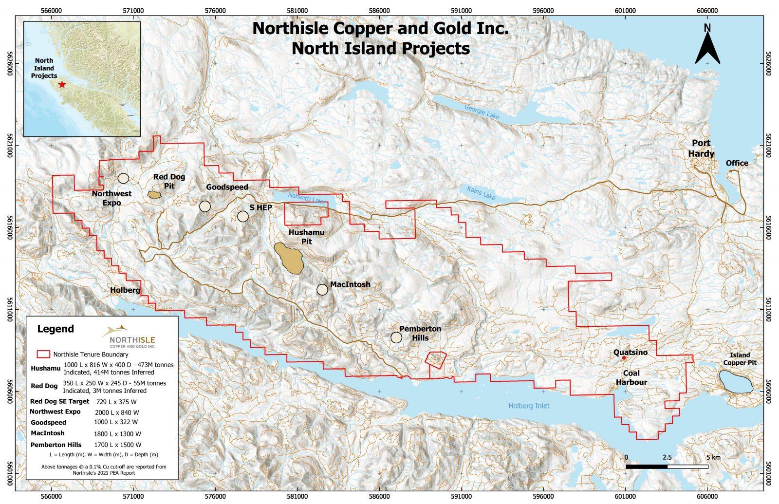
Northisle Copper and Gold Inc. is a Vancouver-based company whose mission is to become a leading and sustainable mineral resource company for the future. Northisle owns the North Island Project, which is one of the most promising copper and gold porphyry deposits in Canada. The North Island Project is located near Port Hardy, British Columbia on a 33,149-hectare block of mineral titles 100% owned by Northisle stretching 50 kilometres northwest from the now closed Island Copper Mine operated by BHP Billiton. Northisle recently completed an updated preliminary economic assessment for the North Island Project and is now focused on advancement of the project through a prefeasibility study while continuing exploration within this highly prospective land package.
Premier American Uranium Inc. (TSX-V: PUR) (OTCQB: PAUIF) is ple... READ MORE
Osisko Development Corp. (NYSE: ODV) (TSX-V: ODV) is pleased to a... READ MORE
High-grade intercepts include 3.5 g/t over 8 meters and 1.2 g/t Au over ... READ MORE
Grid Metals Corp. (TSX-V:GRDM) (OTCQB:MSMGF) is pleased to report... READ MORE
Gold Hunter Resources Inc. (CSE: HUNT) (OTCQB: HNTRF) (Frankfurt:... READ MORE


