


Potential to Increase Resource Grade and Add Tonnage in Future Resource Estimate
Highlights:
Northisle Copper and Gold Inc. (TSX-V: NCX) is pleased to announce complete assay results from its 2021 drill program. Results at Hushamu include intercepts of mineralization with grades significantly above the existing Indicated Resource estimate. At Northwest Expo, NW21-04 intersected significant gold grades which extend the gold-rich zone to the east. The remaining 2021 assays at the Northwest Expo target confirm the existence of an extensive porphyry system while results at Macintosh suggest that the significant area of alteration represents an extension of the Hushamu hydrothermal system which warrants further exploration.
Table 1: Hushamu 2021 Significant Intercepts
| DDHID | From (m) | To (m) | Interval (m) | True width (m) | Cu % | Au g/t | Mo % | Re g/t | Au Equiv g/t | Cu Equiv % |
| HU21-01 | 333 | 480.25 | 147.25m | 140 | 0.306 | 0.419 | 0.013 | 0.806 | 0.905 | 0.670 |
| HU21-02 | 179 | 197 | 18 | 18 | 0.219 | 0.294 | 0.009 | 0.415 | 0.637 | 0.472 |
| and | 216 | 222 | 6 | 6 | 0.295 | 0.25 | 0.009 | 0.532 | 0.698 | 0.517 |
| and | 263 | 306 | 43 | 43 | 0.184 | 0.298 | 0.011 | 0.705 | 0.609 | 0.451 |
| and | 322.25 | 387 | 64.75 | 64.75 | 0.225 | 0.188 | 0.010 | 0.423 | 0.543 | 0.402 |
| HU21-03 | 312.4 | 330 | 17.6 | 15 | 0.162 | 0.196 | 0.007 | 0.313 | 0.451 | 0.334 |
| and | 339 | 347.4 | 8.4 | 7 | 0.284 | 0.291 | 0.014 | 0.801 | 0.752 | 0.557 |
| and | 407 | 442 | 35 | 31 | 0.412 | 0.521 | 0.018 | 0.747 | 1.170 | 0.866 |
| HU21-04 | 309 | 372 | 63 | 56 | 0.405 | 0.491 | 0.011 | 0.539 | 1.096 | 0.812 |
|
Copper and gold equivalent calculations based on the following metal prices which were used in the Company’s 2021 PEA on the North Island Project: |
||||||||||
| Cu = US$3.25/lb, Au = US$1,650/oz, Mo = US$10/lb, Re = $1,256/kg. Calculations assume 100% recovery; totals may not add due to rounding | ||||||||||
|
Note on equivalent calculation: |
||||||||||
| Copper equivalent is determined by calculating total contained metal value/ tonne, dividing by the copper price, and then dividing the resultant number of pounds of copper by 2204.6. Gold equivalent is determined by calculating total contained metal value/tonne, dividing by the gold price, and then multiplying the resultant number of troy ounces of gold by 31.103. | ||||||||||
Sam Lee, President & CEO of Northisle stated “Our 2021 drilling program was successful and demonstrated the potential of expanding our already large mineral resource base across our 50 km porphyry district. Drilling at Hushamu intersected a zone of copper-gold mineralization, within the existing pit shell, which is more than 50% above the existing resource grade of the deposit. This drilling demonstrates the potential for higher grade intercepts within the Hushamu deposit and has the potential to improve modelled tonnage and grade in future resource estimates. With key exploration catalysts set in motion for this year at Northwest Expo, Pemberton Hills and now Hushamu, we will continue to deliver enduring value for our shareholders in 2022.”
Robin Tolbert, Vice President Exploration of Northisle added “We initiated infill drilling at Hushamu in late 2021, with a goal of targeting high priority under-drilled volumes within the PEA pit shell. These drill holes, combined with a review of previous drill logs, indicate that previous drilling intersected an interpreted fault zone which runs northwest to southeast along the south side of the deposit and which provides an opportunity for improvement to the grades and tonnage in the resource estimate in this area. Northisle is completing a comprehensive review of the assay database to understand the potential for further grade improvement as part of its proposed in-fill program. At Northwest Expo, NW21-04 intersected significant gold grades 175m to the east of previous drilling, and drilling in zones 2 and 3 has confirmed the existence of extensive porphyry style alteration. Our upcoming IP survey in the area is anticipated to generate additional drill targets.”
Figure 1 shows the Company’s existing deposits as well as key exploration targets at the North Island Project. The Hushamu deposit forms the core of the PEA completed by the Company in 2021.
Hushamu 2021 Drill Results
Northisle has now received the assay results of the four drill holes from its 2021 drill program at Hushamu (HU21-01 to HU21-04), which are the first from the extensive in-fill program for the deposit which has the objective of adding drill holes in under-drilled areas of the deposit and converting Inferred Resources to Indicated Resources ahead of the Company’s planned pre-feasibility study. Future drilling is also targeted at extending the resource to the southeast and northwest. An additional six holes have been drilled to date in 2022 and results for these are anticipated by the end of Q2 2022. Significant intercepts from the 2021 drill holes can be found in Table 1 above.
Drill hole collar locations for the 2021 drilling at Hushamu can be found in Table 2, and the drill holes are shown in context in Figure 2, with key sections highlighted (580400E, 580700E, 580800E) in the context of the 2021 PEA proposed final pit outline as well as the surface projection of the Hushamu resource estimate.
Table 2: Hushamu 2021 Drill Hole Collar Locations
| Hole ID | Azimuth | Dip | Easting UTM | Northing UTM | Hole Depth (m) |
| HU21-01 | 360 | -70 | 580416 | 5613998 | 552.0 |
| HU21-02 | 0 | -70 | 580400 | 5613925 | 450.4 |
| HU21-03 | 360 | -65 | 580794 | 5613754 | 581.0 |
| HU21-04 | 0 | -90 | 580694 | 5613781 | 579.0 |
The significance of these four drill holes are:
Figure 3 shows Section 580400E, where HU21-01 and HU21-02 can be seen in the context of previous drill holes.
Figure 4 shows HU21-04 on section 580700E in context.
The drill hole structure log for H17-02 on Figure 4: Section 580700E indicates the presence of a fault zone from 307m to 384 m, and the structure log for EC-172 on Figure 5: Section 580800E indicates the presence of a fault zone between 200 m and 454 m. This may explain the lower grades exhibited in these holes. The objective of future additional drilling like HU21-04 on either side of these ’null’ holes is to increase the resource in these and similar areas elsewhere in the deposit.
Northwest Expo Drilling
All assays for NW21-01 to NW21-08 have now been received. NW21-03 assay results were detailed, along with nearby historical drill holes in Zone 1, in Northisle’s press release dated January 25, 2022 and outlined a significant area of gold-rich mineralization. NW21-04 also contains significant gold intercepts, including over the last 10 metres, as shown in Table 3. NW21-04 intersects gold-rich mineralization at a point approximately 175 metres to the east of NW21-03 and indicates that the gold rich zone could be larger than previously anticipated. As noted in the Company’s March 31, 2022 press release, Northisle intends to complete a resource definition drilling program at Northwest Expo during the second half of 2022.
Table 3: Significant Intercepts in NW21-04
| DDHID | From (m) | To (m) | Length (m) | True width (m) | Cu % | Au g/t | Mo % | Re g/t | Au Equiv g/t | Cu Equiv % |
| NW21-04 | 373 | 406 | 33 | 33 | 0.070 | 0.358 | 0.012 | 0.348 | 0.511 | 0.378 |
| and | 431 | 485 | 54 | 54 | 0.053 | 0.258 | 0.008 | 0.278 | 0.369 | 0.274 |
| and | 500 | 510 (EOH) | 10 | 10 | 0.045 | 0.108 | 0.006 | 0.233 | 0.199 | 0.148 |
The additional drill holes completed in Zones 2 and 3 provided a better understanding the porphyry system at Northwest Expo. The observed styles of alteration and mineralization in drill holes at Northwest Expo are consistent with the current hypothesis that this porphyry system is tilted to the southwest so that the core of the porphyry system lies to the northeast of NW21-08.
Northwest Expo has been the subject of several drill programs dating back to at least 2005. Current exploration is focused on gaining a better understanding of three zones, labelled Zone 1, 2, and 3. Zone 1 contains significant intercepts of gold-rich copper porphyry mineralization and is a compelling target for near-term exploration. Zone 2 exhibits extensive faulting and may represent a down faulted block. Zone 3 contains historic drill intercepts of significant (>0.1 % Cu) copper-gold porphyry mineralization from 91 metres to 176 metres in length.
The objective of the 2021 program at Northwest Expo was to drill test anomalies indicated by limited induced polarization (IP) geophysical surveys completed in 2012. A review of historical drilling from 2005 and 2007, and updated with additional data from 2008, identified several intercepts of economically significant gold and copper which are detailed below.
Figure 6 shows the location of 2021 drilling at Northwest Expo in the context of historical drilling. 2012 IP geophysics identified a 550 metre wide chargeability anomaly (>15mV/V) extending south from a line running northeast from 5619500 North (north of DDH EC-245) to 571400 East (northeast of DDH NW21-02). This anomaly is open to the northeast. The IP/mag survey planned to commence in Q2 2022 will cover that un-surveyed area.
A plan view Northwest Expo, showing the complete 2021 drill holes as well as past drilling, can be found in Figure 6.
Collar data for the relevant drill holes in Zones 1, 2 and 3 can be found on the Company’s website here.
MacIntosh Drill Program
Northisle has now reviewed the preliminary results of the 9 hole, 3,579 metre drill program to test the extensive silica-clay-pyrite (SCP) alteration and chargeability anomalies resulting from the recent geophysical survey at MacIntosh. The drilling confirmed the extensive SCP alteration of Bonanza Formation volcanics/volcaniclastics, diorite and rhyodacite in the area of the ridge south of Hushamu. However, no significant copper, gold or molybdenum values are anticipated from assays. It appears this area is a portion of the southeast arm of the Hushamu hydrothermal system. In order to address limited assay lab capacity, these assays have been deferred until later in 2022. The eastern portion of the Macintosh target is located in the western boundary of the proposed tailings/waste storage for Hushamu, and this drilling has provided increased confidence in the viability of the waste/tailings storage area. The southwest side of MacIntosh is interpreted to be faulted and remains to be explored following the detailed review of assays, geochemistry, mapping and geophysics, as this area remains very much under-drilled.
2022 Surface Geophysical Surveys
Simcoe will resume geophysical surveying on the remaining four regional targets Northwest Expo, Pemberton Hills, Red Dog and Goodspeed once snow clears from these areas. This program is anticipated to be complete in Q3 2022.
Key Exploration Catalysts
Key exploration catalysts for the coming year are detailed in Table 4:
Table 4: Key Exploration Catalysts
| Timing | Category | Details |
| Q2 2022 | Assays | Hushamu Assays |
| Q3 2022 | Preliminary Met. Results | Results from preliminary gold deportment studies and met testing at Northwest Expo |
| Q3 2022 | Surface Exploration | Surface exploration including geophysics at NW Expo, Pemberton, Red Dog and Goodspeed |
| H2 2022 | Drilling | Zone 1 Drill Program at Northwest Expo |
| H2 2022 | Drilling | Continue Hushamu in-fill and step out drilling |
| Q4 2022 | Resource Estimate | Initial resource estimate for NW Expo gold-rich Zone 1 |
| Q4 2022 / Q1 2023 | Trade-off Studies | Preliminary trade-off studies to evaluate impact of NW Expo gold-rich zone on North Island Project |
Logging, Sampling and Assaying Procedures
The diamond drill core logging and sampling program was carried out under a rigorous quality assurance / quality control program using industry best practices. Drill intersections in this release are typically HQ to 100 m and NQ thereafter to the end of holes. After drilling, core was logged for geology, structure, and geotechnical characteristics utilizing Geospark© core logging software, then marked for sampling and photographed on site. The cores for analyses were marked for sampling based on geological intervals with individual samples 3 m or less in length. Drill core was cut lengthwise in half with a core saw. Half-core was sent for assays reported in this news release. Prior to cutting core for assay bulk density was also determined on site by taking 20 to 25 cm lengths of whole core of each lithology at 10 m intervals. The ends of these were then cut at right angle to the core axis, retaining all pieces to be returned to the core box for later sample cutting and analysis. The diameter of each core sampled for bulk density was measured at each end with digital calipers to 3 decimal places and recorded. The length of the core was measured on four sides at 90 degrees to each other, to 2 decimal places and recorded. The software averaged the lengths and diameters. The mass of the dry core was measured twice on an Ohaus© balance to 2 decimal places. If no discrepancy occurred the measurement was recorded. If there was a discrepancy the measuring was repeated until no discrepancy between 2 measurements occurred. The density was calculated using the formula Bulk Density = π times r² times h (where r is radius of core and h is length of core). Certified standard masses are used to calibrate the scale balance used for bulk density determinations. The balance in the core logging area was levelled on a large concrete block to avoid vibration, was leveled, and surrounded by a wooden partition to avoid wind affecting the balance. The measurements were recorded in Geospark© logging software and Bulk Density calculated to 2 decimal places.
A total of 5% assay standards or blanks and 5% core duplicates are included in the sample stream as a quality control measure and are reviewed after analyses are received. Standards were obtained from WCM Minerals, Vancouver and CDN Minerals, Langley. Blanks were obtained from unmineralized course bagged limestone landscaping rock. Standards and blanks in 2021 drill results to date have been approved as acceptable. Duplicate data add to the long-term estimates of precision for assay data on the project and precision for drill results reported is deemed to be within acceptable levels. Samples were sent to the Bureau Veritas laboratory in Vancouver, BC where the samples were dried, then crushed, split and a 250 g split was pulverized to 85% passing 200 mesh size pulps. Clean crush material was passed through the crusher and clean silica was pulverized between each sample. The pulps were analyzed for gold by fire assay fusion of 50 g of the 250 g split. Total gold content was determined by digesting the silver doré bead from the fusion and then analysing by ICP/ES (Bureau Veritas Code FA350-Au). All samples were also analyzed for multiple elements by taking a 0.25 g of the 250g split which was heated in HNO3, HClO4 and HF to fuming and taken to dryness. The residue was dissolved in HCl and then analyzed utilizing ICP-ES/MA (Bureau Veritas Code MA200). Bureau Veritas (Vancouver) is an independent, international ISO/IEC 17025:2005 accredited laboratory.
Pulps and rejects of holes with significant assay intervals are stored at Western Mineral Storage. The remaining split core is indexed and stored at Northisle logging and office facility in Port Hardy, BC.
Results in this news release are length weighted averages.
Qualified Person
Robin Tolbert, P.Geo., Vice President Exploration of Northisle and a Qualified Person as defined by National Instrument 43-101, has approved the scientific and technical disclosure contained in this news release.
About Northisle
Northisle Copper and Gold Inc. is a Vancouver-based company whose mission is to become a leading and sustainable mineral resource company for the future. Northisle owns the North Island Project, which is one of the most promising copper and gold porphyry deposits in Canada. The North Island Project is located near Port Hardy, British Columbia on a 33,149-hectare block of mineral titles 100% owned by Northisle stretching 50 kilometres northwest from the now closed Island Copper Mine operated by BHP Billiton. Northisle recently completed an updated preliminary economic assessment for the North Island Project and is now focused on advancement of the project through a prefeasibility study while continuing exploration within this highly prospective land package.
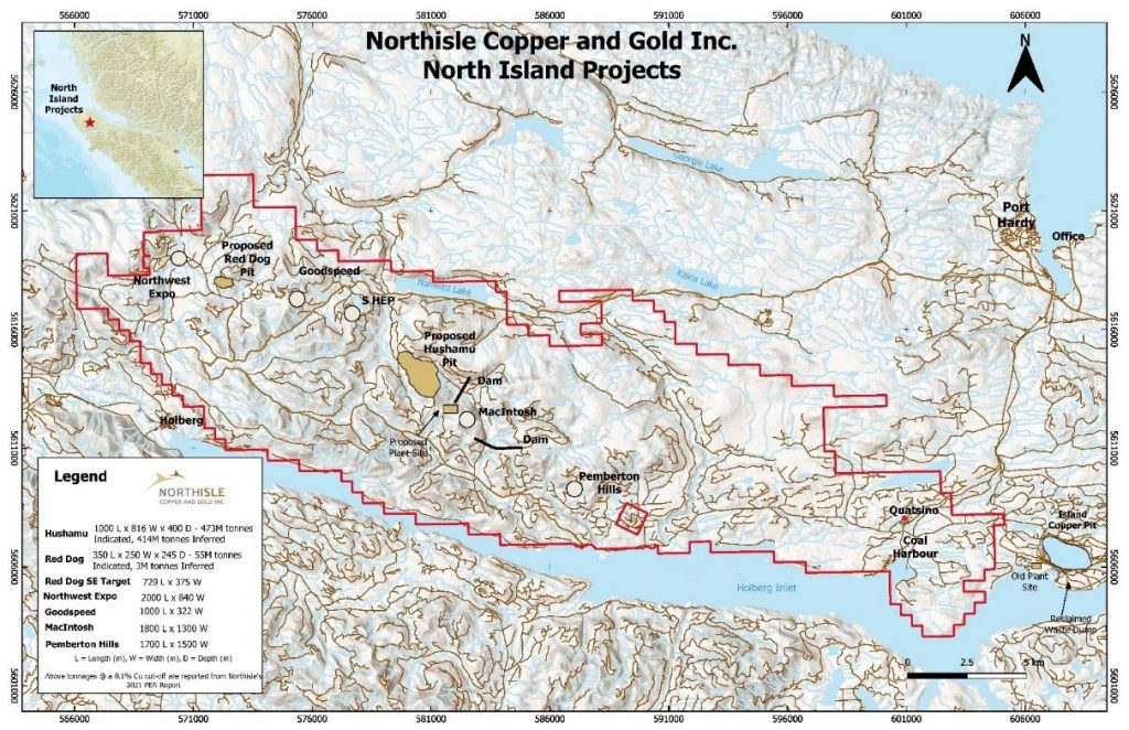
Figure 1: North Island Project Map
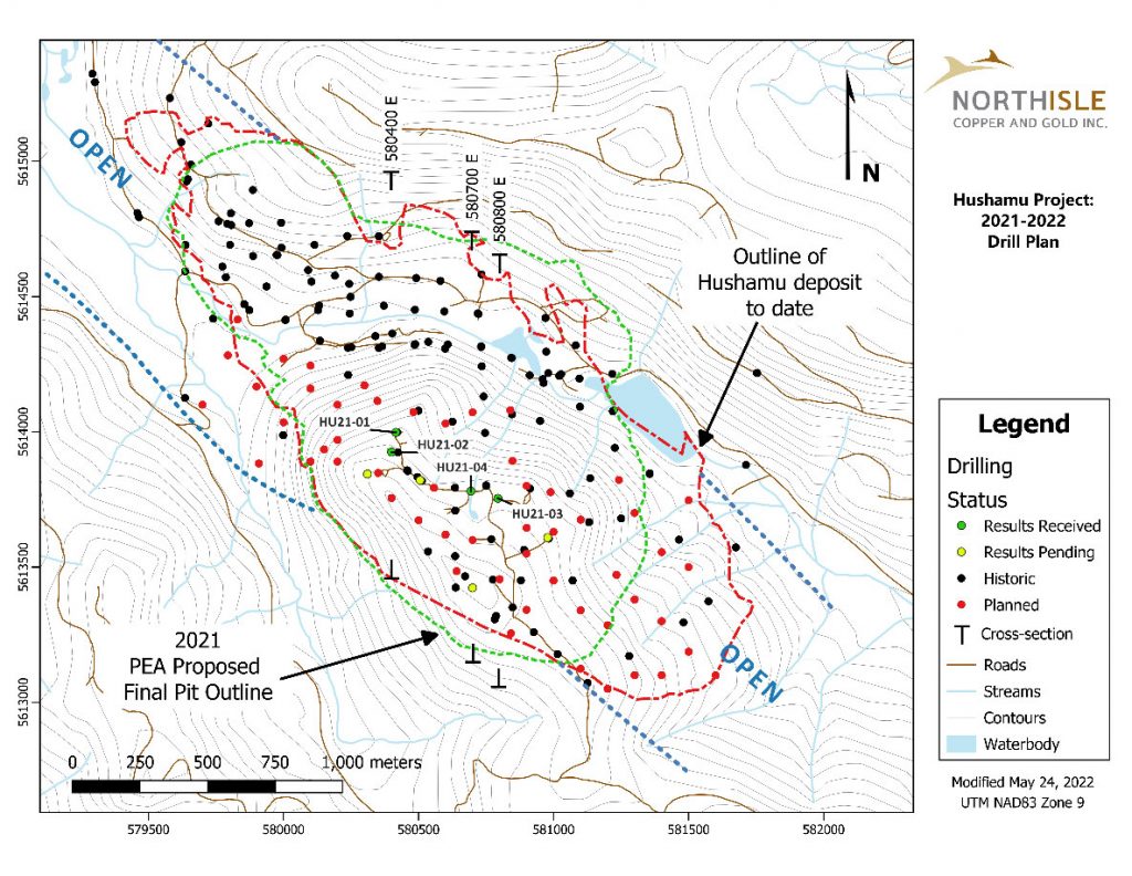
Figure 2: Hushamu Deposit Drilling Plan Map
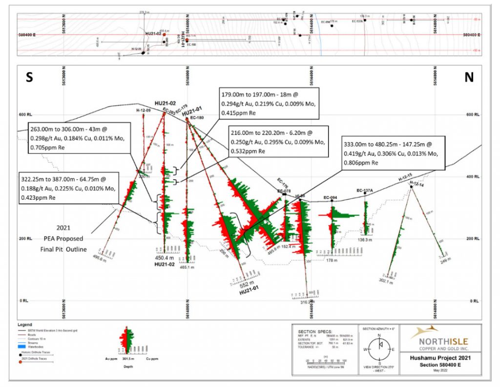
Figure 3: Section 580400E
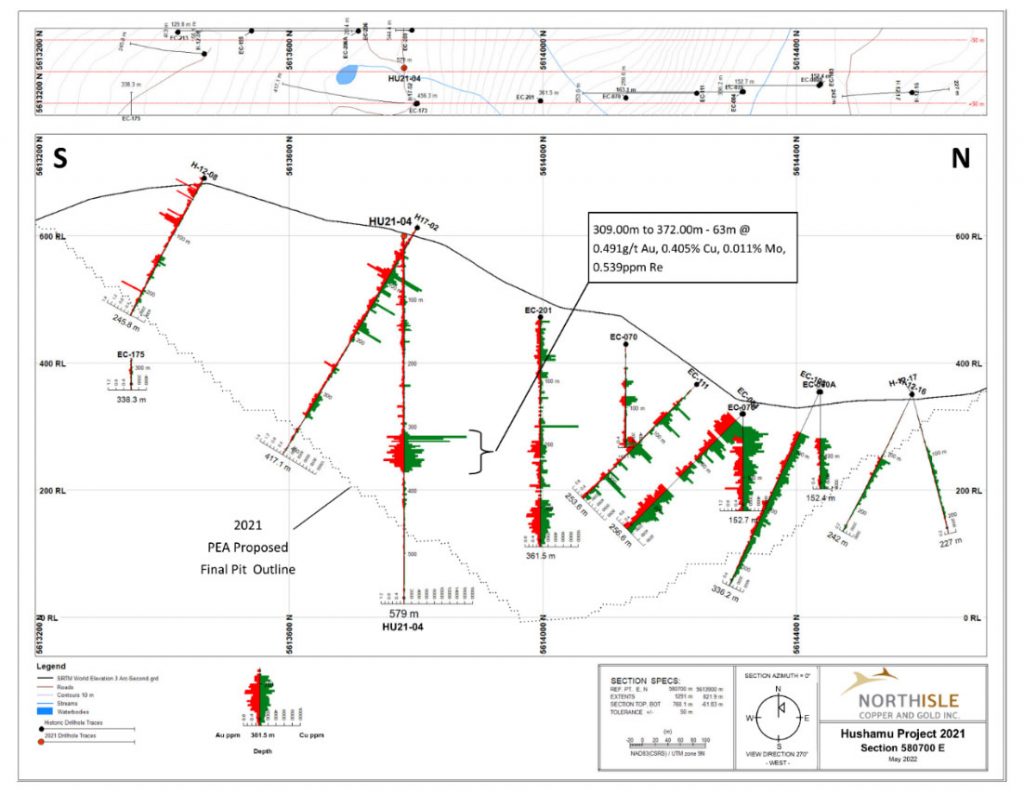
Figure 4: Section 580700E
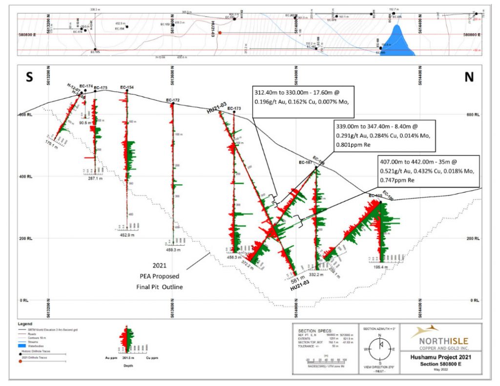
Figure 5: Section 580800E
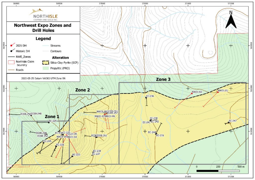
Figure 6: Northwest Expo Zones and Drill Holes
Masivo Silver Corp. (TSX-V: MASS) (OTC Pink: GNYPF) (FSE: R74) is... READ MORE
Spanish Mountain Gold Ltd. (TSX-V: SPA) (FSE: S3Y) (OTCQB: SPAUF)... READ MORE
NevGold Corp. (TSX-V:NAU) (OTCQX:NAUFF) (Frankfurt:5E50) is pleas... READ MORE
SAGA Metals Corp. (TSX-V: SAGA) (OTCQB: SAGMF) (FSE: 20H) a No... READ MORE
Revival Gold Inc. (TSX-V: RVG) (OTCQX: RVLGF) is pleased to provi... READ MORE


