








North Sky Metals Corp. (TSX-V:NSKY) is pleased to announce assay results from its maiden drill program, including a higher-grade interval within a broader interval of lower-grade gold mineralization, at the West target on the Natlan Project located approximately 24 km northeast of New Hazelton in west-central British Columbia (Figure 1).
Drill hole NAT26DD004 returned 15.35 metres of 1.65 g/t gold, including 3.0 metres of 7.34 g/t gold, within 61.85 metres of 0.56 g/t gold. This intercept represents the first higher-grade gold intersected in drilling at the West target, where the best result from the two historical 2005 holes was 1.53 g/t gold over 3.0 m. All six holes intersected gold mineralization, and five holes returned continuous intervals ranging from 182.0 up to 318.5 metres in core length.
This release reports results from all six holes (1,865 metres) drilled at the West target, the first half of the 12-hole, 4,372-metre 2026 program. Assay results for the six holes (2,507 metres) drilled at the Ace porphyry target are pending.
Highlights
“Our first drill program at the West target intersected a higher-grade gold zone in hole NAT26DD004,” said Scott Ansell, President and CEO of North Sky. “We intersected gold across approximately 350 metres of the soil anomaly and to more than 300 metres vertically below surface, with individual samples grading up to 20.1 g/t gold. More than half of the soil anomaly remains untested, and the system is open along strike and at depth. The six holes we’re reporting today are all from the West target and represent the first half of our 12-hole program.”
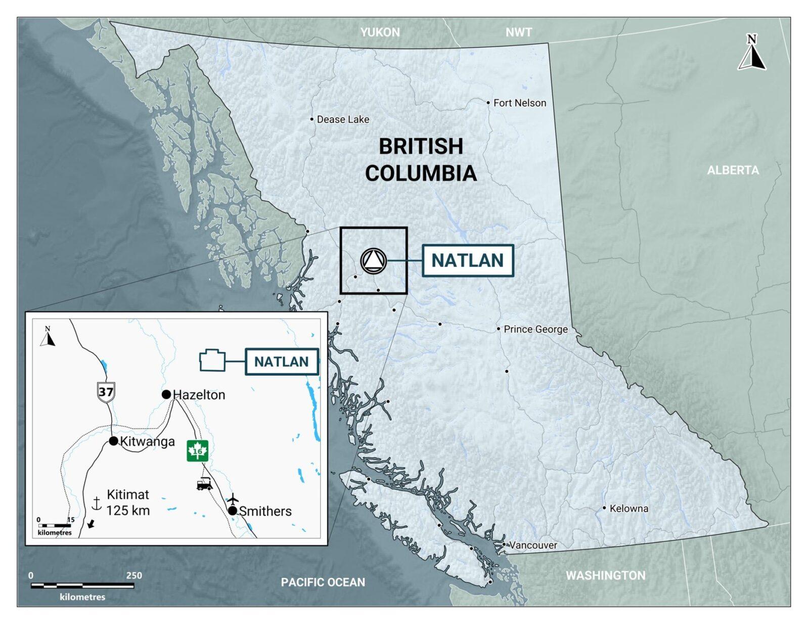
Figure 1. Location of the Natlan Project, west-central British Columbia.
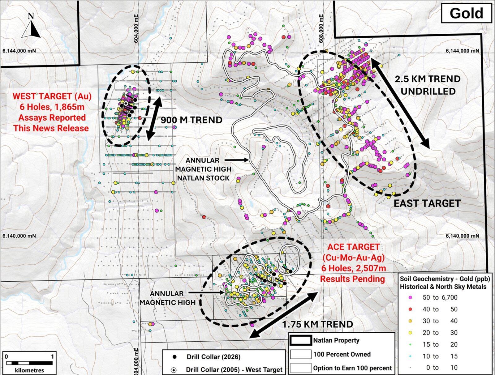
Figure 2. Natlan Project gold soil geochemistry, with target areas and 2026 drilling.
Drill Results
North Sky’s first drill program at the West target intersected gold in all six holes, including several higher-grade intervals. Totalling 1,865 metres, the holes tested the target from both sides: five were collared upslope and along strike from the two historical drill holes, and NAT26DD004 was collared downslope. Drilling extended deeper than the historical holes and tested approximately 350 metres of the soil anomaly (Figure 3). Significant intervals are listed in Table 1 and drill hole details in Table 2.
Four holes returned samples grading above 1 g/t gold, with the highest assays of 20.1 and 13.3 g/t gold in NAT26DD004. Higher grades are associated with closely spaced veins and intrusive contacts, which will be used to guide targeting and hole orientations for the 2027 program. The Company plans to test extensions of these higher-grade intervals and to step out along strike and at depth to test the extent of the broad intervals of continuous gold mineralization.
NAT26DD004 was collared on the west side of the target and drilled back toward the other five holes. The hole intersected gold mineralization from 97.0 m to 373.0 m depth (end of hole), representing a 276 m interval averaging 0.21 g/t gold. Within this interval, the hole returned 160.35 m of 0.31 g/t gold from 123.15 m, including a 61.85 m interval of 0.56 g/t gold, 15.35 m of 1.65 g/t gold, 3.0 m of 7.34 g/t gold and 0.5 m of 20.1 g/t gold. The highest grades are hosted within and around a feldspar porphyry dyke with a breccia along its upper contact. A second higher-grade interval of 6.0 m of 1.00 g/t gold occurs at the base of the 61.85 m interval from 179.0 m, and further down the hole a 0.5 m sample of 10.2 g/t gold at 275.25 m shows that higher-grade gold occurs well beyond it. Confirmation of the grade and orientation of the mineralized zone and identifying additional higher-grade intervals, are priorities for 2027 drilling (Figure 4).
The higher-grade zone in NAT26DD004 lies within a broad system of lower-grade gold mineralization centred on a 900 m by 550 m gold-arsenic soil anomaly that coincides with a 1 km north-trending magnetic low. The 2026 drilling tested about 350 m along strike of the soil anomaly and intersected gold along the eastern margin of the magnetic low. Mineralization begins directly below the overburden and remains open to the north and south and at depth.
NAT26DD002 and NAT26DD003 were drilled from the central pad, approximately 290 m east of NAT26DD004, beneath the central part of the soil geochemical anomaly, and both returned more than 300 metres of continuous gold mineralization. NAT26DD002 returned gold values from 8.0 m depth to the end of the hole, intersecting 316.0 m of 0.12 g/t gold, including 73.1 m of 0.21 g/t gold from 120.4 m and a 0.6 m sample of 9.62 g/t gold. The steeper NAT26DD003 intersected 318.5 m of 0.11 g/t gold, including 57.5 m of 0.20 g/t gold from 192.5 m. Together, the two holes intersected gold mineralization from just below surface to more than 300 m vertical depth beneath a single pad, with higher average grades below approximately 100 m down the hole and remaining elevated at depth (Figure 5).
NAT26DD001 and NAT26DD005 stepped out to the south and north of the central pad, approximately 260 m from each other, and both intersected long intervals of gold mineralization. NAT26DD001 intersected 250.5 m of 0.10 g/t gold starting from 4.0 m down the hole, including 44.5 m of 0.15 g/t gold and a 0.5 m sample of 4.42 g/t gold (Figure 4). NAT26DD005 returned 182.0 m averaging 0.10 g/t gold from 40.0 m depth. Within that interval, a 54.46 m section cut by multiple dykes averaged 0.15 g/t gold (Figure 6). The Company interprets the two holes as indicating that mineralization extends along strike.
NAT26DD006 was collared approximately 100 m south of NAT26DD001, and extended gold mineralization to the south, intersecting 30.63 m of 0.10 g/t gold from 156.0 m, mainly within a sulphide-bearing wacke unit, including 6.0 m of 0.25 g/t gold, and 3.25 m of 0.36 g/t gold from 112.0 m depth. The hole was drilled in sedimentary rocks cut by feldspar porphyry dykes, south of the quartz diorite intersected in NAT26DD001, which hosts most of the gold mineralization in the other holes. The hole was stopped early, at 222.0 m, in faulted and broken graphitic sedimentary rocks, and the southern extent of the quartz diorite remains to be tested (Figure 7).
In these six holes, the 2026 program intersected gold mineralization across approximately 350 m of the soil geochemical anomaly. Mineralization extends directly below the overburden, from 4.0 m in NAT26DD001 and 8.0 m in NAT26DD002, and continues to the bottom of NAT26DD002 and NAT26DD004, which both ended in mineralization.
“Every hole at the West target intersected gold mineralization starting just below the overburden, and two holes ended in mineralization,” said Arron Albano, Exploration Manager of North Sky. “Most of the gold mineralization is hosted in quartz diorite intrusions and extends into the surrounding sedimentary rocks. We have two priorities for follow-up drilling: first, we want to determine the orientation of the higher-grade zone intersected in NAT26DD004 and test for extensions of those intervals; second, we want to step out to the north and south and drill deeper to test how far the mineralization extends, as it remains open along strike and at depth.”
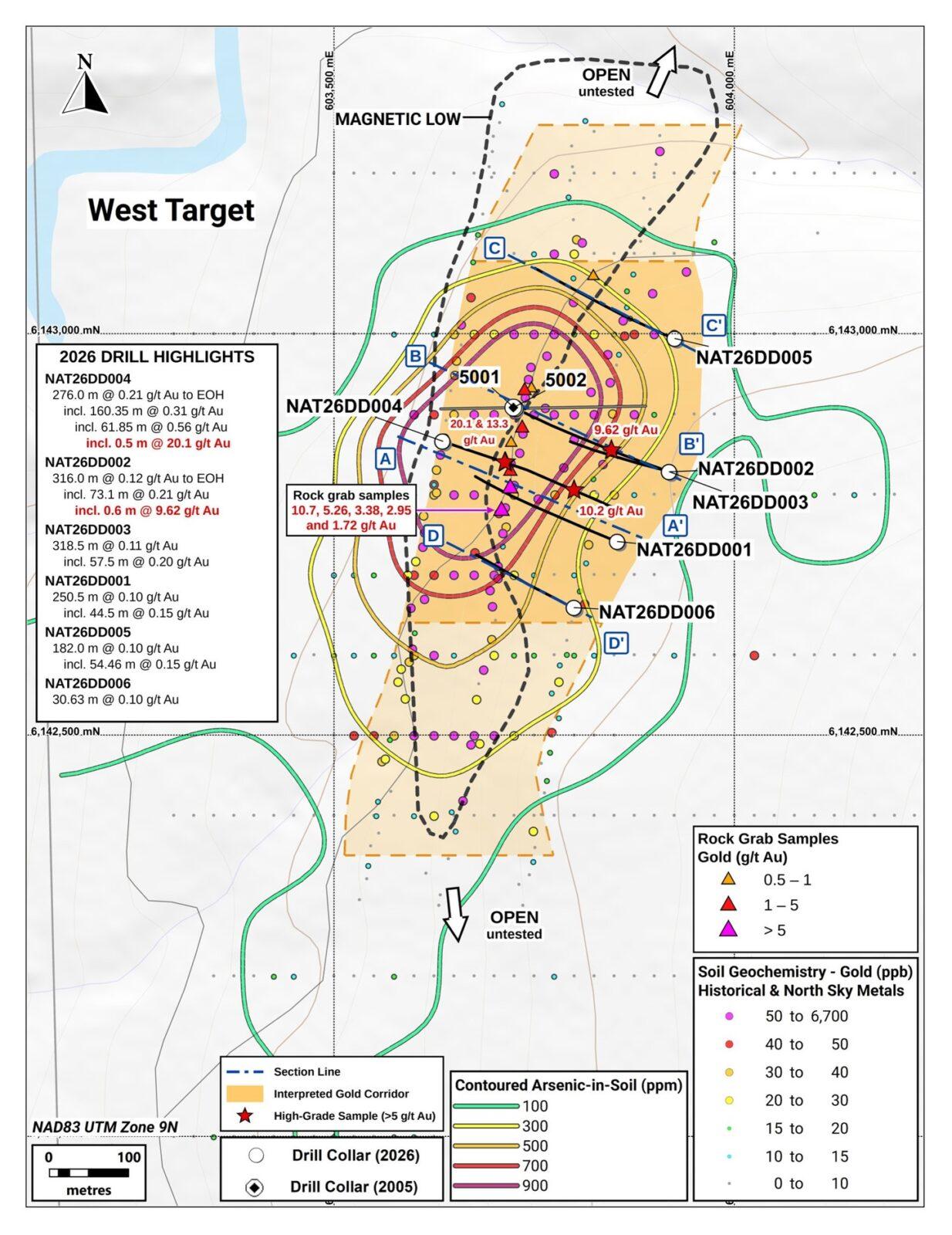
Figure 3. West target plan map showing 2026 and historical 2005 drill holes with significant gold intervals and higher-grade samples, rock grab samples above 0.5 g/t gold, gold-in-soil geochemistry, contoured arsenic-in-soil, the magnetic low, the interpreted gold corridor and the locations of cross-sections A–A’ to D–D’ (Figures 4 to 7).
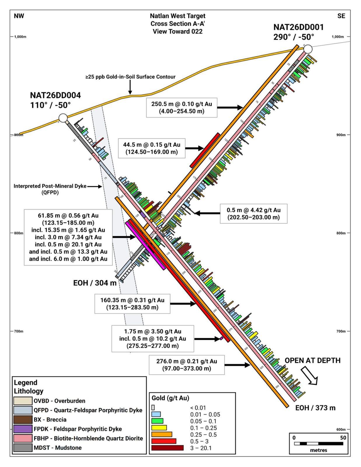
Figure 4. Cross-section A–A’ through NAT26DD004 and NAT26DD001, West target, showing gold intervals.
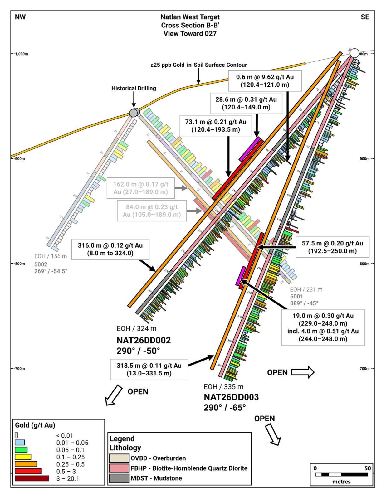
Figure 5. Cross-section B–B’ through NAT26DD002, NAT26DD003 and historical 2005 holes 5001 and 5002, West target, showing gold intervals.
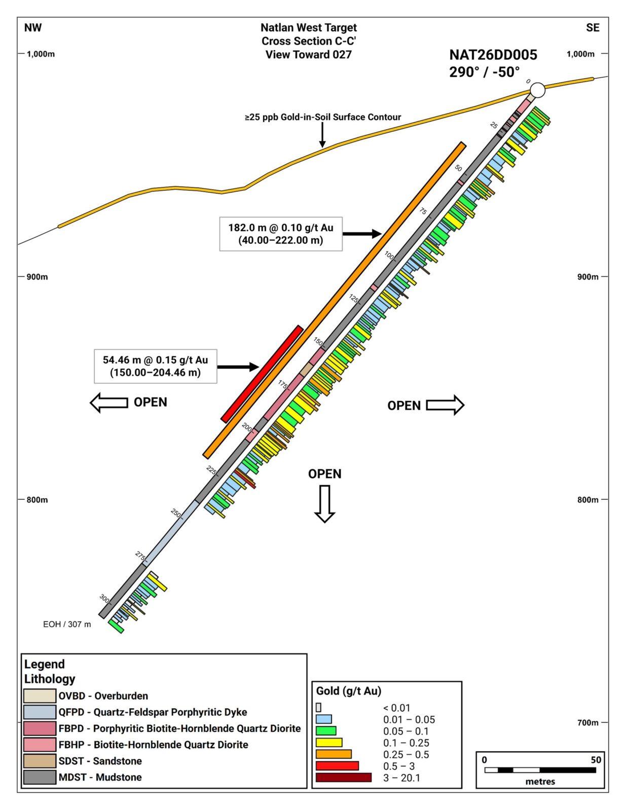
Figure 6. Cross-section C–C’ through NAT26DD005, West target, showing gold intervals.
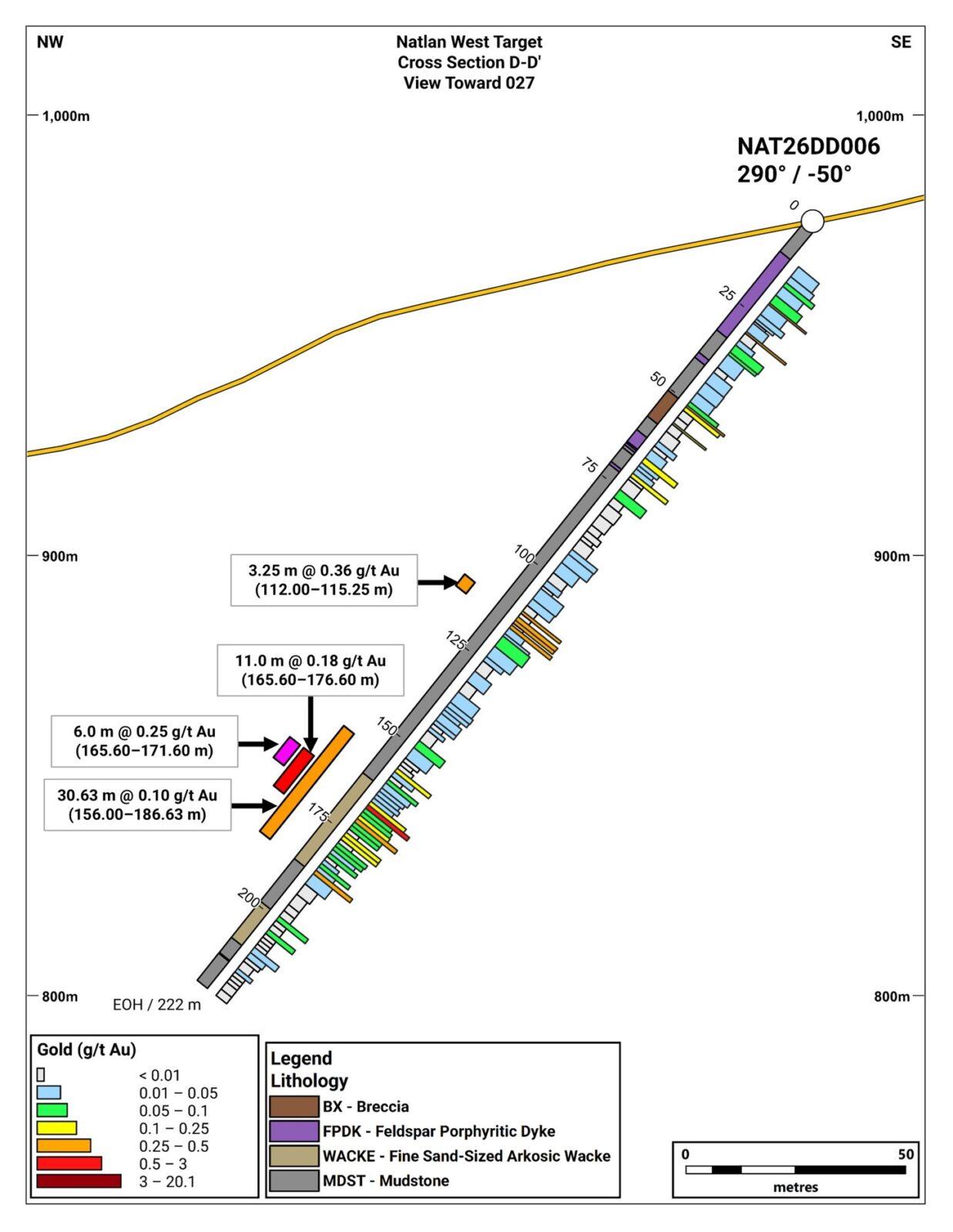
Figure 7. Cross-section D–D’ through NAT26DD006, West target, showing gold intervals.
Table 1. Significant gold intervals, West target, holes NAT26DD001 to NAT26DD006
| Hole ID | Interval | From (m) | To (m) | Length (m) | Au (g/t) |
| NAT26DD004 | Main (to EOH) | 97.00 | 373.00 | 276.00 | 0.21 |
| incl. | 123.15 | 283.50 | 160.35 | 0.31 | |
| incl. | 123.15 | 185.00 | 61.85 | 0.56 | |
| incl. | 123.15 | 138.50 | 15.35 | 1.65 | |
| incl. | 128.50 | 131.50 | 3.00 | 7.34 | |
| incl. | 130.00 | 130.50 | 0.50 | 20.10 | |
| and incl. | 128.50 | 129.00 | 0.50 | 13.30 | |
| and incl. | 179.00 | 185.00 | 6.00 | 1.00 | |
| and incl. | 275.25 | 277.00 | 1.75 | 3.50 | |
| incl. | 275.25 | 275.75 | 0.50 | 10.20 | |
| NAT26DD002 | Main (to EOH) | 8.00 | 324.00 | 316.00 | 0.12 |
| incl. | 120.40 | 193.50 | 73.10 | 0.21 | |
| incl. | 120.40 | 149.00 | 28.60 | 0.31 | |
| incl. | 120.40 | 121.00 | 0.60 | 9.62 | |
| NAT26DD003 | Main | 13.00 | 331.50 | 318.50 | 0.11 |
| incl. | 192.50 | 250.00 | 57.50 | 0.20 | |
| incl. | 229.00 | 248.00 | 19.00 | 0.30 | |
| incl. | 244.00 | 248.00 | 4.00 | 0.51 | |
| NAT26DD001 | Main | 4.00 | 254.50 | 250.50 | 0.10 |
| incl. | 124.50 | 169.00 | 44.50 | 0.15 | |
| and incl. | 202.50 | 203.00 | 0.50 | 4.42 | |
| NAT26DD005 | Main | 40.00 | 222.00 | 182.00 | 0.10 |
| incl. | 150.00 | 204.46 | 54.46 | 0.15 | |
| NAT26DD006 | Main | 156.00 | 186.63 | 30.63 | 0.10 |
| incl. | 165.60 | 176.60 | 11.00 | 0.18 | |
| incl. | 165.60 | 171.60 | 6.00 | 0.25 | |
| and | 112.00 | 115.25 | 3.25 | 0.36 |
Intervals are length-weighted averages over core length; grades are uncapped. True widths are not yet known. EOH = hole ended in mineralization. “incl.” intervals are contained within the interval above; “and incl.” denotes a separate sub-interval within the main interval; “and” denotes a separate interval in the same hole. Main intervals were calculated using a 0.10 g/t gold cut-off, beginning and ending on samples at or above the cut-off, with a maximum of 23.5 m of continuous internal dilution.
Table 2. West target 2026 diamond drill hole details (UTM NAD83 Zone 9N)
| Hole ID | Easting | Northing | Elev. (m) | Azimuth (°) | Dip (°) | Length (m) | Status |
| NAT26DD001 | 603854 | 6142741 | 988 | 290 | -50 | 304 | Reported |
| NAT26DD002 | 603919 | 6142828 | 1001 | 290 | -50 | 324 | Reported |
| NAT26DD003 | 603919 | 6142828 | 1001 | 290 | -65 | 335 | Reported |
| NAT26DD004 | 603636 | 6142866 | 917 | 110 | -50 | 373 | Reported |
| NAT26DD005 | 603926 | 6142994 | 984 | 290 | -50 | 307 | Reported |
| NAT26DD006 | 603800 | 6142659 | 976 | 290 | -50 | 222 | Reported |
The NAT26DD006 collar coordinates and the six West target collar elevations in Table 2 supersede the corresponding values in Table 1 of the Company’s November 3, 2026, news release.
West Target
The West target is an approximately 900 m long by 550 m wide gold-arsenic soil geochemical anomaly (Figure 2), largely hidden beneath overburden and mature forest and crossed by an old logging road. The target lies along a north-trending magnetic low interpreted as a potential controlling structure, and gold mineralization in the 2026 holes occurs along the eastern margin of this feature, which extends for approximately 1 km. Quartz-arsenopyrite vein and altered feldspar porphyry float collected along the road has returned up to 10.7 g/t gold in grab samples, and the 2026 drilling has demonstrated broad intervals of gold mineralization and locally higher gold values at depth, with core samples of 20.1 and 13.3 g/t gold in NAT26DD004. The only previous drilling, two historical holes from a single pad in 2005, returned 162 m of 0.17 g/t gold, including 84 m of 0.23 g/t gold, in historical hole 5001.
Gold mineralization at the West target is hosted in both intrusive and sedimentary rocks. The main host is a biotite-hornblende quartz diorite that forms bodies up to approximately 240 m in core length intruding mudstone, siltstone and wacke, and carries most of the gold values in the long, continuous intervals in Table 1. The sedimentary rocks also host several samples above 1 g/t gold, and both rock types are variably to strongly altered to carbonate-sericite-silica assemblages. Gold occurs with pyrrhotite, arsenopyrite, pyrite and minor chalcopyrite, in carbonate and quartz-carbonate veins and as closely associated disseminations, and higher grades are associated with more sulphides and strong bismuth and tellurium enrichment.
Two features appear to control where the gold is concentrated: vein density, and intrusive contacts, which are notably close to the eastern margin of the magnetic low. Gold grades increase with vein density: zones with more than one vein per metre make up about a third of the core drilled but carry nearly three-quarters of the gold. Holes drilled from opposite directions intersected the veins at a range of angles, and cross-cutting relationships in the core indicate several vein sets. The highest grades occur within veins at intrusive contacts, in a feldspar porphyry dyke with a breccia along its upper contact in NAT26DD004 and at the upper contact of the quartz diorite in NAT26DD002, where the 9.62 g/t gold sample was returned. At the target scale, drilling suggests that gold mineralization follows the north-trending eastern margin of the magnetic low (Figure 3).
Next Steps
At the West target, the 2026 results give North Sky a clear set of targets for 2027. The mineralization remains open at depth and along strike to the north and south. The 2026 holes have only tested approximately 350 m of the 900 m by 550 m gold-arsenic soil geochemical anomaly, leaving more than half of its length untested. The results will be integrated with geological logging, the Project’s geophysical and surface geochemical data and the MobileMT survey to plan follow-up drilling. Sulphide content and gold grades increase with depth in the 2026 holes, and much of the best mineralization intersected lies below the depth covered by the existing IP surveys. A deeper-penetrating, higher-resolution IP survey is therefore planned for 2027 to trace the mineralized system at depth and along strike.
At the Ace porphyry target, assays are pending for the six holes (2,507 metres) of the first-ever drill test of the target and will be reported as they are received.
Exploration Permitting
North Sky holds multi-year area-based (MYAB) Mines Act permits covering the Project, one for the Natlan claims (valid to March 2031) and one for the Ace claims (valid to March 2030), which together authorize up to 100 helicopter-supported drill sites and 115 line-km of IP surveys across the Ace, West and East targets. The Company is fully permitted for follow-up drilling at West.
First Nations
The Natlan Project lies within the traditional territory of the Gitxsan Nation, on the lax yip (territories) of the Hereditary Chiefs Luutkudziiwus and Yagosip. North Sky’s engagement with the Chiefs is ongoing and hands-on. This includes regular meetings, information sharing and updates on the Company’s activities, as well as helicopter visits to the Project so the Chiefs can see the work firsthand and return to areas of their territories where their families have lived, harvested and kept their adaawk (oral histories) for generations. The Chiefs are compensated for their time, which supports the feast system that underpins Gitxsan governance and benefits the wider Gitxsan community.
These visits also give the Company a direct view of the Chiefs’ priorities for the land, foremost among which are water and fish habitat.
North Sky regards consultation as a long-term relationship and not a one-time permitting step and incorporates the Chiefs’ knowledge of the land into how and where it works. The 2026 program was also supported by local and regional businesses, including Raven 37 for field labour and Skookum Daxgyet Services for drill pad construction.
QA/QC and Sampling Protocol
All drill core was logged, photographed and sampled on site by Company personnel. Sample intervals at the West target were generally 1 to 2 metres and were adjusted to geological contacts. Core was cut in half with a diamond saw, with one half sent for analysis and the other retained for reference. Certified reference materials, blanks, field duplicates and coarse reject duplicates were inserted into the sample stream at a rate of approximately one for every six core samples; QA/QC samples are excluded from the intervals reported in Table 1.
Company personnel delivered samples to the ALS Canada Ltd. preparation facility in Terrace, British Columbia, where samples are crushed to 70% passing 2 mm and a 250 g split is pulverized to 85% passing 75 microns. Pulps were analyzed at ALS in North Vancouver for gold by 30 g fire assay with an ICP-AES finish (Au-ICP21); samples returning more than 10 g/t gold were re-assayed by fire assay with a gravimetric finish (Au-GRA21), and the gravimetric result is reported. Samples were also analyzed by multi-element analysis (48 elements) using a four-acid digestion with an ICP-MS finish (ME-MS61). ALS is independent of the Company.
About the Natlan Project
The 10,065 hectare Natlan Project consists of 14 contiguous mineral tenures in the Omineca Mining Division, approximately 24 km northeast of New Hazelton and within 23 km of the provincial power grid and 18 km of the CN rail line. North Sky owns 100% of the Ace claims and holds an option to earn a 100% interest in the Natlan claims. The Project lies near the southeastern margin of the Bowser Basin, close to the Skeena Arch, and is underlain by Bowser Lake Group sedimentary rocks intruded by the Late Cretaceous Natlan stock and related dyke swarms of the Bulkley plutonic suite, which is associated with porphyry deposits in the region.
The Project has been explored intermittently since 1967. More than 3,500 soil samples, including B- and C-horizon soils, talus fines and Ah (humus) soils, and more than 800 rock samples have been collected across the Project, including 1,675 soil and 298 rock samples collected by North Sky in 2023 and 2024. North Sky has also completed a 360 line-km airborne magnetic survey and approximately 24 line-km of IP surveying. Further information on the Project is available in the NI 43-101 technical report titled “NI 43-101 Technical Report on the Natlan Project in west-central British Columbia, Canada” by Jean Pautler, P.Geo., with an effective date of June 30, 2026, available on the Company’s profile on SEDAR+ (www.sedarplus.ca) and on the Company’s website at www.northskymetals.com.
Qualified Person
The scientific and technical information contained in this news release has been reviewed and approved by Arron Albano, B.Sc., P.Geo., Exploration Manager for North Sky Metals Corp., who is a Qualified Person as defined by National Instrument 43-101 – Standards of Disclosure for Mineral Projects. Mr. Albano is not independent of the Company. Mr. Albano has verified the 2026 drilling data disclosed in this news release, including sampling and analytical data, by reviewing the Company’s drill logs and databases against the original ALS analytical certificates and reviewing the results of the QA/QC program. The historical 2005 drilling results have not been independently verified by the Qualified Person and are presented for context only.
Assay results from surface rock samples referenced in this news release are summarized in the Company’s NI 43-101 technical report on the Natlan Project. Grab samples are selective by nature and values reported may not be representative of mineralized zones.
Historical Data
Results from the two 2005 drill holes referenced in this news release are historical in nature and were obtained by a previous operator. The Company has not verified the sampling, analytical or QA/QC procedures used, and a Qualified Person has not done sufficient work to verify these results. They are presented for context only and should not be relied upon.
ABOUT NORTH SKY METALS CORP.
North Sky Metals Corp. is a Canadian mineral exploration company focused on copper and gold projects in Canada. The Company’s flagship 100 km² Natlan Project in west-central British Columbia, comprising the 100%-owned Ace claims and the Natlan claims under option to earn a 100% interest, hosts the Ace and East copper porphyry targets and the West gold target, all fully permitted for drilling. The Company also holds the 110 km² Jet copper project in Nunavut. North Sky is focused on advancing these and other projects through disciplined, discovery-driven exploration.
Canuc Resources Corporation (TSX-V: CDA) (OTCQB: CNUCF) (WKN: A41... READ MORE
Results include 7.75 g/t Au over 6.4 m in hole 26-SPX-DD003 and 7... READ MORE
TDG Gold Corp. (TSX-V: TDG) (OTCǪX: TDGGF) is pleased to announ... READ MORE
OceanaGold Corporation (TSX: OGC) (NYSE: OGC) announces explorati... READ MORE