


North Peak Resources Ltd. (TSX-V: NPR) is providing an update on the work programs underway pursuant to its option to purchase the Black Horse gold property located near Ely Nevada. In December 2021 the Company signed an agreement for the option with Minex LLC, and then obtained the necessary drilling permits. Following a review of the historical data of the 316 holes previously drilled, an 8-hole core drilling program to twin the main zones of the property and a 20-hole reverse circulation drilling program to test other zones were launched (see Appendix 1)
“The assay results for the first 6 twin core holes have finally been received and while indicating gold mineralization, they have yet to confirm historic Black Horse drilling results either in grade or mineralized intercept as presented in the table below,” said Brian Hinchcliffe CEO of the Company. “These assay results are so vastly different from what Minex received on the Black Horse Property back in the late 1990’s, that together with Minex we will carry out a gold grade determination review as well as sending samples to a second lab for umpire assays.”
| MINEX RC HOLE (historic) |
FROM
(M) |
TO
(M) |
INTERVAL
(M) |
GRADE
AU (g/t) |
NORTH PEAK DRILL HOLE (twin) |
FROM
(M) |
TO
(M) |
INTERVAL
(M) |
GRADE
AU (g/t) |
| BH 218 | 0 | 6.1 | 6.1 | 8.7 | NP22-001 | 6.1 | 6.1 | NIL | |
| 48.8 | 54.9 | 6.1 | 0.5 | 48.9 | 52.2 | 3.3 | 0.3 | ||
| incl. | 50.4 | 52.0 | 1.5 | 1.4 | |||||
| BH 165 | 18.3 | 30.5 | 12.2 | 3.6 | NP22-002 | 19.5 | 21.0 | 1.5 | 0.2 |
| incl. | 24.4 | 30.5 | 6.1 | 6.1 | 26.0 | 27.7 | 1.7 | 1.6 | |
| 3.8 | 5.8 | 2.0 | 0.3 | ||||||
| BH 89 | 45.7 | 57.9 | 12.2 | 7.3 | NP22-003 | ||||
| incl. | 48.8 | 51.8 | 3.0 | 27.5 | 48.8 | 51.8 | 3.0 | LOST CORE |
|
| 52.0 | 61.0 | 9.0 | 0.3 | ||||||
| BH 225 | 82.3 | 109.7 | 27.4 | 2.3 | NP22-004 | 69.2 | 77.0 | 7.8 | 0.3 |
| incl. | 82.3 | 94.5 | 12.2 | 4.4 | incl. | 75.9 | 77.0 | 1.1 | 1 |
| 97.9 | 100.6 | 2.7 | 0.3 | ||||||
| BH 249 | 33.5 | 36.6 | 3.0 | 3.4 | NP22-007 | 44.2 | 44.4 | 0.1 | 5.7 |
| 42.7 | 48.8 | 6.1 | 2.8 | 36.3 | 36.9 | 0.2 | 0.3 | ||
| 51.5 | 54.9 | 1.0 | 0.2 |
Summary
Drilling campaigns by Minex in 1997-1998 drilled 316 RC holes that identified a mineralization zone that appears to have a strike length of two miles with drilling generally at 100-foot centers. Approximately 65% of the gold mineralization occurs in hydrothermally altered and micro-veined quartzite inter-layered beds of mica schist in the Pre-Cambrian McCoy Creek group. Most of the gold mineralization in the quartzite appears to be stratiform and varies from 20-100 feet in thickness and following a major thrust structure – representing the conduit for gold fluids. The Cambrian Lincoln Peak limestone overlies the Precambrian McCoy Creek group and is in the thrust fault contact with the Precambrian McCoy Creek group.
The historical drilling was interpreted to have intersected this 30 degree to 45 degree dipping mineralization but the mines were all on vertical to sub-vertical structures both in the limestone and in the quartzite. It is thought that at least some of the higher-grade mineralization in the historical vertical RC holes intersected vertical mineralization and so, twinning these holes makes duplicating the results very difficult; follow up drilling is being undertaken with angled holes dipping to the NW.
While details of the holes drilled and assays received to date are set forth in Appendices 2 and 3, the following is a summary of those results:
The vertical twin holes 001 and 008 are being followed up with angled holes because it is thought the historical holes intersected vertical mineralization. Drill hole 003 is being redrilled due to complete lost core at the target depth where the historical high-grade result was indicated to be located.
Review by Qualified Person, Quality Control and Reports
Michael Sutton, P.Geo., a Director of the Company, is the Qualified Person who supervised the preparation of the scientific and technical disclosure in this news release on behalf of the Company. All core and RC samples referenced herein were assayed by Bureau Veritas, located at 605 Boxington Way Ste 101, Sparks, Nevada. The lab has ISO 17025, ISO14001 and OHSAS 18001 Certifications. All core and RC samples are under watch from the drill site to the core processing facility. All samples are assayed for gold by 30g Fire Assay Analysis with AAS finish. If the results are greater than 10ppm then 30g Fire Assay Analysis (gravimetric finish) is completed. The Company’s QA/QC program includes the regular insertion of blanks and standards into the sample shipments, as well as instructions for duplication. Standards and blanks are inserted randomly at one each per 20 samples. It is planned that 5% of samples with grades above 0.005 opt (but none of nil value) are to be sent to a second lab. All samples greater than 0.150 opt are to be included and the rest in increments of grades. Core recovery in the mineralized zones has averaged 83.8%.
Neither the Company nor the Qualified Person can at this time independently verify the historical information on the Black Horse Property, particularly regarding historical drill results reported by Minex and its procedures used for sample collection and analysis. Therefore, readers are encouraged to exercise appropriate caution when evaluating historical drill results. What has been described to the Company, is that for historical assays, Legend Inc. 988 Packer Way, Sparks, NV 89431 undertook 30-gram fire assay on all the samples sent in. If the result met the stipulation of >0.020 opt, then the additional (duplicate) tests were run. CN bottle roll tests were carried out with 1000 grams at -100 mesh on a small subset of the samples that were >0.050 opt.
About North Peak Resources
The Company is a Canadian based gold exploration and development company that is listed on the TSX Venture Exchange under the symbol “NPR”. The Company holds an option to acquire the 2,733-acre Black Horse gold and silver property located approximately 50 miles east of Ely within the Black Horse mining district in White Pine County, Nevada. See the Company’s January 11, 2022 press release for additional information.
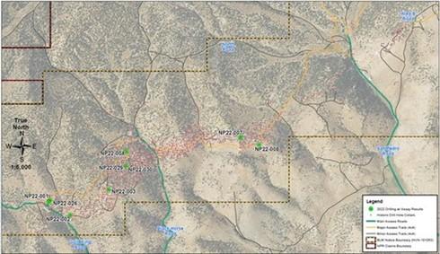
APPENDIX 1: Surveyed Drill Hole Collar locations (CNW Group/North Peak Resources Ltd.)
APPENDIX 2: Drill Hole Collar Locations
| HOLE ID | AREA | TYPE | EASTING | NORTHING | ELEVATION | AZIMUTH | DIP | DEPTH | |
| (FT) | (M) | ||||||||
| NP22-001 | Area A | Core | 860584.2 | 1604216.0 | 7341.4 | 90 | 320 | 97.5 | |
| NP22-002 | Area A | Core | 860981.6 | 1603935.0 | 7332.2 | 90 | 158 | 48.2 | |
| NP22-003 | Area A | Core | 861665.3 | 1604397.0 | 7400.0 | 90 | 200 | 61.0 | |
| NP22-004 | Area A | Core | 861990.6 | 1605074.0 | 7360.0 | 90 | 364 | 110.9 | |
| NP22-007 | Area A | Core | 864076.3 | 1605357.0 | 7473.6 | 90 | 180 | 54.9 | |
| NP22-008 | Area A | Core | 864412.9 | 1605227.0 | 7405.5 | 90 | 83 | 25.3 | |
| NP22-026 | Area A | Core | 860579.0 | 1604176.1 | 7337.0 | 8 | -58 | 600 | 182.9 |
| NP22-029 | Area A | RC | 861994.9 | 1604824.2 | 7371.0 | 341 | -54 | 500 | 152.4 |
| NP22-030 | Area A | RC | 861994.9 | 1604824.2 | 7371.0 | 302.5 | -47 | 550 | 167.6 |
APPENDIX 3: Gold mineralisation intercepts
| HOLE ID | FROM | TO | INTERVAL | GRADE AU
(G/T) |
CORE
RECOVERY (%) |
|||
| (FT) | (M) | (FT) | (M) | (FT) | (M) | |||
| NP22-001 | 160.5 | 48.9 | 171.2 | 52.2 | 10.7 | 3.3 | 0.3 | 90 % |
| incl. | 160.5 | 48.9 | 162.5 | 49.5 | 2 | 0.6 | 0.7 | 91 % |
| incl. | 165.5 | 50.4 | 170.5 | 52.0 | 5 | 1.5 | 1.4 | 80 % |
| 160.5 | 48.9 | 179.0 | 54.6 | 18.5 | 5.6 | 0.2* | 92 % | |
| incl. | 171.2 | 52.2 | 179.0 | 54.6 | 7.8 | 2.4 | 0.14* | 98 % |
| 251.0 | 76.5 | 253.0 | 77.1 | 2 | 0.6 | 0.4 | 93 % | |
| NP22-002 | 12.5 | 3.8 | 19.0 | 5.8 | 6.5 | 2.0 | 0.3 | 80 % |
| 64.0 | 19.5 | 69.0 | 21.0 | 5 | 1.5 | 0.2 | 95 % | |
| 85.4 | 26.0 | 91.0 | 27.7 | 5.6 | 1.7 | 1.6 | 79 % | |
| NP22-003 | 68.0 | 20.7 | 68.5 | 20.9 | 0.5 | 0.2 | 0.2 | 100 % |
| 145.0 | 44.2 | 147.5 | 45.0 | 2.5 | 0.8 | 0.6 | 95 % | |
| 170.5 | 52.0 | 200.0 | 61.0 | 29.5 | 9.0 | 0.3 | 86 % | |
| incl. | 170.5 | 52.0 | 173.0 | 52.7 | 2.5 | 0.8 | 0.8 | 100 % |
| incl. | 196.0 | 59.7 | 200.0 | 61.0 | 4 | 1.2 | 0.6 | 68 % |
| NP22-004 | 227.0 | 69.2 | 252.5 | 77.0 | 25.5 | 7.8 | 0.3 | 97 % |
| incl. | 228.0 | 69.5 | 233.0 | 71.0 | 5 | 1.5 | 0.6 | 100 % |
| incl. | 249.0 | 75.9 | 252.5 | 77.0 | 3.5 | 1.1 | 1.0 | 92 % |
| 269.0 | 82.0 | 275.0 | 83.8 | 6 | 1.8 | 0.2 | 100 % | |
| 288.0 | 87.8 | 294.5 | 89.8 | 6.5 | 2.0 | 0.2 | 69 % | |
| 321.3 | 97.9 | 330.0 | 100.6 | 8.7 | 2.7 | 0.3 | 100 % | |
| 323.0 | 98.5 | 325.0 | 99.1 | 2 | 0.6 | 0.6 | 100 % | |
| 348.5 | 106.2 | 351.1 | 107.0 | 2.6 | 0.8 | 0.2 | 96 % | |
| 353.5 | 107.7 | 357.0 | 108.8 | 3.5 | 1.1 | 0.2 | 100 % | |
| NP22-007 | 119.0 | 36.3 | 121.1 | 36.9 | 2.1 | 0.6 | 0.3 | 54 % |
| 145.0 | 44.2 | 145.7 | 44.4 | 0.7 | 0.2 | 5.7 | 100 % | |
| 159.0 | 48.5 | 160.9 | 49.0 | 1.9 | 0.6 | 0.3 | 100 % | |
| 169.0 | 51.5 | 180.0 | 54.9 | 11 | 3.4 | 0.2 | 99 % | |
| incl. | 173.0 | 52.7 | 176.0 | 53.6 | 3 | 0.9 | 0.4 | 100 % |
| NP22-026 | 187.0 | 57.0 | 191.5 | 58.4 | 4.5 | 1.4 | 0.2 | NA |
| 212.1 | 64.6 | 219.3 | 66.8 | 7.2 | 2.2 | 0.2 | NA | |
| 266.9 | 81.4 | 269.0 | 82.0 | 2.1 | 0.6 | 0.3 | NA | |
| NP22-029 | 0.0 | 0.0 | 10.0 | 3.0 | 10 | 3.0 | 0.2 | NA |
| 195.0 | 59.4 | 205.0 | 62.5 | 10 | 3.0 | 0.3 | NA | |
| 255.0 | 77.7 | 260.0 | 79.2 | 5 | 1.5 | 0.2 | NA | |
| 280.0 | 85.3 | 285.0 | 86.9 | 5 | 1.5 | 0.6 | NA | |
| 350.0 | 106.7 | 355.0 | 108.2 | 5 | 1.5 | 0.5 | NA | |
| 390.0 | 118.9 | 405.0 | 123.4 | 15 | 4.6 | 0.3 | NA | |
| 440.0 | 134.1 | 455.0 | 138.7 | 15 | 4.6 | 0.2 | NA | |
| incl. | 450.0 | 137.2 | 455.0 | 138.7 | 5 | 1.5 | 0.4 | NA |
| 470.0 | 143.3 | 475.0 | 144.8 | 5 | 1.5 | 0.2 | NA | |
| NP22-030 | 20.0 | 6.1 | 30.0 | 9.1 | 10 | 3.0 | 0.3 | NA |
| 180.0 | 54.9 | 215.0 | 65.5 | 35 | 10.7 | 0.3 | NA | |
| 370.0 | 112.8 | 375.0 | 114.3 | 5 | 1.5 | 0.2 | NA | |
| 430.0 | 131.1 | 435.0 | 132.6 | 5 | 1.5 | 0.2 | NA | |
| 525.0 | 160.0 | 530.0 | 161.5 | 5 | 1.5 | 0.3 | NA | |
| incl.= including; intersections used 0.005 oz/t Au (0.17 g/t) for the bottom cut-off except for: * at a 0.004 oz/t Au (0.14 g/t) cut-off; True widths are unknown at this time due to two known orientations to mineralization to date; Drill hole NP22-008 did not produce significant assays | ||||||||
Confirms strong metallurgical potential and local processing capa... READ MORE
Standard Uranium Ltd. (TSX-V: STND) (OTCQB: STTDF) (FSE: 9SU0) ... READ MORE
Drilling Program Confirms Significant Graphitic Fault Zones and Associat... READ MORE
Second Highest Grade Intercept to Date on Ogden Project 115.51 g/... READ MORE
Wallbridge Mining Company Limited (TSX: WM) (OTCQB:WLBMF) is plea... READ MORE


