








New Pacific Metals Corp. (TSX: NUAG) (NYSE American: NEWP), together with its local Bolivian partner, announce the assay results of the last ten drill holes from the Discovery Drill Program completed in 2021 at the Carangas Silver-Gold Project, Oruro Department, Bolivia. Assay results of all 35 holes drilled in 2021 (Figure 1) have now been received and released. Drill intercepts of mineralization and hole specifications of the last ten holes are presented in Tables 1 and 2, respectively. Drilling is underway on the 2022 drilling program of up to an additional 40,000 metres.
Highlights
Gold mineralization intersected in hole DCAr0031, is hosted in strongly argillic-sericitized lithic tuff of dacitic composition with disseminated sulfides and cut by veinlets of pyrite and chalcopyrite, similar to the holes DCAr0020, DCAr0016 and DCAr0015 reported previously (Figure 2).
Nine holes in Table 1 were drilled at a shallow dip angle of -45 degrees targeting the near surface silver-rich polymetallic mineralization at various locations in Central Valley, West Dome and East Dome and intersected broad silver-rich mineralization near surface. The only deep hole, DCAr0031 was drilled at a higher dip angle of -68 degrees to a depth of 757.23 m, which intersected 595.7 m interval of gold. The gold mineralization may represent a feeder zone that is related to multi-stage rhyolitic/dacitic porphyry intrusive bodies.
| Table 1 Summary of Drill Intercepts
|
||||||||||
| Hole_ID | Depth_from | Depth_to | Interval_m | Ag_g/t | Au_g/t | Pb_% | Zn_% | Cu_% | AgEq_g/t | |
| DCAr0026 | 8.00 | 355.64 | 347.64 | 19 | 0.02 | 0.32 | 0.85 | 0.01 | 60 | |
| incl. | 8.00 | 74.00 | 66.00 | 60 | 0.01 | 0.50 | 0.74 | 0.02 | 102 | |
| DCAr0027 | 1.78 | 74.48 | 72.70 | 116 | 1.34 | 0.02 | 0.02 | 157 | ||
| incl. | 12.95 | 48.68 | 35.73 | 213 | 1.46 | 0.03 | 0.02 | 258 | ||
| 266.26 | 268.74 | 2.48 | 22 | 1.17 | 2.13 | 0.02 | 130 | |||
| 337.70 | 352.90 | 15.20 | 38 | 0.10 | 0.26 | 0.01 | 51 | |||
| 393.57 | 394.72 | 1.15 | 229 | 0.10 | 1.39 | 1.03 | 0.08 | 312 | ||
| DCAr0028 | 10.47 | 201.44 | 190.97 | 65 | 0.48 | 1.09 | 0.02 | 118 | ||
| incl. | 57.18 | 89.00 | 31.82 | 101 | 0.95 | 2.59 | 0.02 | 219 | ||
| incl. | 178.90 | 195.93 | 17.03 | 347 | 1.01 | 1.79 | 0.06 | 443 | ||
| DCAr0029 | 4.84 | 33.92 | 29.08 | 31 | 0.36 | 0.01 | 0.01 | 42 | ||
| 57.43 | 119.59 | 62.16 | 28 | 0.43 | 0.49 | 0.01 | 58 | |||
| 145.00 | 165.00 | 20.00 | 31 | 0.15 | 0.48 | 0.01 | 52 | |||
| 185.62 | 191.14 | 5.52 | 30 | 0.22 | 0.50 | 0.01 | 53 | |||
| 215.94 | 239.20 | 23.26 | 31 | 0.20 | 0.54 | 0.02 | 56 | |||
| 282.87 | 293.35 | 10.48 | 29 | 0.19 | 0.44 | 0.01 | 50 | |||
| DCAr0030 | 35.57 | 195.67 | 160.10 | 65 | 0.32 | 0.93 | 0.01 | 107 | ||
| incl. | 56.20 | 88.85 | 32.65 | 216 | 0.63 | 1.65 | 0.03 | 292 | ||
| DCAr0031 | 62.37 | 161.55 | 99.18 | 21 | 0.02 | 0.55 | 1.38 | 0.04 | 90 | |
| incl. | 62.37 | 104.00 | 41.63 | 41 | 0.02 | 1.00 | 1.72 | 0.06 | 135 | |
| 161.55 | 757.25 | 595.70 | 7 | 1.25 | 0.08 | 0.08 | 0.07 | 108 | ||
| incl. | 457.30 | 556.20 | 98.90 | 6 | 2.58 | 0.04 | 0.02 | 0.09 | 200 | |
| incl. | 711.00 | 753.11 | 42.11 | 2 | 3.51 | 0.00 | 0.01 | 0.10 | 262 | |
| DCAr0032 | 18.30 | 213.00 | 194.70 | 33 | 0.37 | 0.71 | 0.01 | 85 | ||
| incl. | 129.30 | 143.73 | 14.43 | 158 | 0.29 | 0.25 | 0.03 | 390 | ||
| 319.89 | 330.14 | 10.25 | 1213 | 1.20 | 0.19 | 0.03 | 1257 | |||
| DCAr0033 | 21.04 | 151.74 | 130.70 | 36 | 0.39 | 1.12 | 0.01 | 86 | ||
| 210.37 | 259.35 | 48.98 | 27 | 0.23 | 0.84 | 0.01 | 63 | |||
| 280.65 | 288.53 | 7.88 | 20 | 0.64 | 1.25 | 0.01 | 82 | |||
| DCAr0034 | 57.13 | 544.40 | 487.27 | 17 | 0.04 | 0.19 | 0.40 | 0.01 | 39 | |
| incl. | 57.13 | 69.00 | 11.87 | 60 | 0.03 | 0.10 | 0.05 | 69 | ||
| incl. | 114.30 | 136.20 | 21.90 | 57 | 0.13 | 0.28 | 70 | |||
| incl. | 154.43 | 194.40 | 39.97 | 76 | 0.04 | 0.39 | 0.82 | 0.02 | 119 | |
| incl. | 521.48 | 540.80 | 19.32 | 20 | 0.18 | 0.82 | 1.96 | 0.11 | 133 | |
| 565.62 | 587.18 | 21.56 | 5 | 0.06 | 0.36 | 0.63 | 0.01 | 42 | ||
| DCAr0035 | 69.25 | 151.74 | 82.49 | 44 | 0.42 | 0.44 | 71 | |||
| incl. | 69.25 | 93.74 | 24.49 | 106 | 0.59 | 0.38 | 137 | |||
| 163.14 | 172.20 | 9.06 | 36 | 0.37 | 0.55 | 0.01 | 66 | |||
| 211.05 | 229.70 | 18.65 | 34 | 0.11 | 0.04 | 0.01 | 40 | |||
| Notes: | ||||||||||
| 1. | Drill location, altitude, azimuth, and dip of drill holes are provided in Table 2. | |||||||||
| 2. | Drill intercept is core length, and grade is length weighted. True width of mineralization is unknown due to early stage of exploration without adequate drill data. | |||||||||
| 3. | Calculation of silver equivalent (“AgEq”) is based on the long-term median of the August 2021 Street Consensus Commodity Price Forecasts, which are US$22.50/oz for Ag, US$0.95/lb for Pb, US$1.10/lb for Zn, US$3.40/lb for Cu, and US$1,600/oz for Au. The formula used for the AgEq calculation is as follows: AgEq = Ag g/t + Pb g/t * 0.0029 + Zn g/t * 0.00335 + Cu g/t * 0.01036 + Au g/t * 71.1111. This calculation assumes 100% recovery. Due to the early stage of the Project, the Company has not yet completed metallurgical test work on the mineralization encountered to date. | |||||||||
| 4. | A cut-off of 20 g/t AgEq is applied for calculation of length-weighted intercept. At times, samples lower than 20 g/t AgEq may be included in the calculation of consolidation of mineralized intercepts. | |||||||||

Figure 1. Simplified geology map and drill holes of the 2021 Discovery Drill Program at Carangas Project
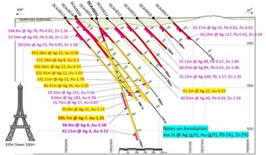
Figure 2. DCAr0031 on section 24 was terminated in gold mineralization due to drill difficulty
Update on the 2022 Drilling Campaign
The Company currently has four drill rigs turning at the Carangas Project and plans to complete up to 40,000 m drilling this year. Of the four drill rigs, two rigs are testing the shallow silver horizon and the other two rigs are testing the gold mineralization at depth. So far, approximately 10,000 m have been completed in 15 holes. Assay results of 15 drill holes completed in 2022 are pending.
The Company has attempted to drill beyond 1,000 m depth to follow gold mineralization and has encountered thermal water at around 900 m depth. The Company is seeking to have a fifth rig capable of 1,500 m depth to test potential mineralization of rhyolitic bodies.
| Table 2 Summary of Drill Hole Locations for the Carangas Project | ||||||||||
| Hole_id | Easting | Northing | Altitude | Depth_m | Azimuth (°) | Dip (°) | Date_start | Date_complete | Target | |
| DCAr0001 | 538772.76 | 7905618.95 | 4041.21 | 300.40 | 120 | -55 | 6/21/2021 | 6/30/2021 | W. Dome | |
| DCAr0002 | 538770.64 | 7905615.47 | 4041.15 | 200.00 | 225 | -40 | 7/2/2021 | 7/8/2021 | W. Dome | |
| DCAr0003 | 538760.06 | 7905564.79 | 4026.90 | 150.00 | 240 | -40 | 7/8/2021 | 7/12/2021 | W. Dome | |
| DCAr0004 | 538825.50 | 7905612.16 | 4036.96 | 250.00 | 46 | -50 | 7/12/2021 | 7/16/2021 | W. Dome | |
| DCAr0005 | 538783.47 | 7905661.22 | 4053.84 | 250.00 | 151 | -40 | 7/16/2021 | 7/26/2021 | W. Dome | |
| DCAr0006 | 538963.00 | 7905485.07 | 3942.23 | 300.00 | 30 | -45 | 7/27/2021 | 8/3/2021 | W. Dome | |
| DCAr0007 | 539384.66 | 7905187.61 | 3936.85 | 300.00 | 20 | -45 | 8/4/2021 | 8/9/2021 | E. Dome | |
| DCAr0008 | 539333.52 | 7905281.06 | 3921.15 | 350.00 | 20 | -45 | 8/10/2021 | 8/15/2021 | E. Dome | |
| DCAr0009 | 539586.93 | 7905157.90 | 4006.31 | 250.00 | 20 | -45 | 8/16/2021 | 8/19/2021 | E. Dome | |
| DCAr0010 | 539181.76 | 7905464.48 | 3907.98 | 206.00 | 20 | -45 | 8/19/2021 | 8/24/2021 | C. Valley | |
| DCAr0011 | 539151.56 | 7905372.66 | 3907.46 | 250.00 | 20 | -45 | 8/26/2021 | 8/30/2021 | C. Valley | |
| DCAr0012 | 539118.40 | 7905290.73 | 3907.18 | 400.00 | 20 | -45 | 8/31/2021 | 9/12/2021 | C. Valley | |
| DCAr0013 | 538877.56 | 7905023.91 | 3911.64 | 584.00 | 50 | -45 | 9/13/2021 | 9/25/2021 | S. Dome | |
| DCAr0014 | 539076.98 | 7905212.97 | 3906.16 | 500.00 | 20 | -45 | 10/6/2021 | 10/13/2021 | C. Valley | |
| DCAr0015 | 539034.51 | 7905133.70 | 3905.39 | 600.00 | 20 | -45 | 10/6/2021 | 10/15/2021 | C. Valley | |
| DCAr0016 | 539001.02 | 7905050.01 | 3904.10 | 761.00 | 20 | -45 | 10/17/2021 | 10/31/2021 | C. Valley | |
| DCAr0017 | 539217.59 | 7905550.63 | 3907.29 | 311.00 | 20 | -45 | 10/15/2021 | 10/20/2021 | C. Valley | |
| DCAr0018 | 538788.93 | 7905507.35 | 4012.26 | 400.00 | 20 | -70 | 10/18/2021 | 10/27/2021 | W. Dome | |
| DCAr0019 | 539211.99 | 7905304.71 | 3907.55 | 353.00 | 20 | -45 | 10/21/2021 | 10/27/2021 | C. Valley | |
| DCAr0020 | 538841.11 | 7905102.85 | 3918.24 | 650.00 | 50 | -45 | 11/2/2021 | 11/13/2021 | S. Dome | |
| DCAr0021 | 538794.55 | 7905508.55 | 4012.67 | 350.00 | 77 | -45 | 10/28/2021 | 11/9/2021 | W. Dome | |
| DCAr0022 | 539250.95 | 7905397.84 | 3908.65 | 350.00 | 20 | -45 | 10/28/2021 | 11/3/2021 | C. Valley | |
| DCAr0023 | 539282.77 | 7905481.73 | 3908.50 | 300.00 | 20 | -45 | 11/4/2021 | 11/9/2021 | C. Valley | |
| DCAr0024 | 539191.18 | 7905204.23 | 3907.07 | 476.10 | 20 | -45 | 11/10/2021 | 11/16/2021 | C. Valley | |
| DCAr0025 | 538829.52 | 7905615.97 | 4036.95 | 200.00 | 250 | -40 | 11/10/2021 | 11/14/2021 | W. Dome | |
| DCAr0026 | 538990.16 | 7905279.65 | 3905.53 | 450.00 | 20 | -45 | 11/14/2021 | 11/22/2021 | C. Valley | |
| DCAr0027 | 538773.94 | 7905612.53 | 4041.03 | 401.00 | 200 | -60 | 11/15/2021 | 11/22/2021 | W. Dome | |
| DCAr0028 | 539040.73 | 7905409.95 | 3907.11 | 300.00 | 20 | -45 | 11/18/2021 | 11/22/2021 | C. Valley | |
| DCAr0029 | 538829.40 | 7905369.78 | 3966.60 | 300.00 | 55 | -45 | 11/24/2021 | 11/28/2021 | W. Come | |
| DCAr0030 | 539073.78 | 7905483.71 | 3908.83 | 257.00 | 20 | -45 | 11/23/2021 | 11/28/2021 | C. Valley | |
| DCAr0031 | 539049.54 | 7905156.60 | 3905.49 | 758.00 | 20 | -68 | 11/22/2021 | 12/18/2021 | C. Valley | |
| DCAr0032 | 539336.17 | 7905281.10 | 3921.04 | 400.00 | 75 | -45 | 11/29/2021 | 12/5/2021 | C. Valley | |
| DCAr0033 | 538879.37 | 7905252.35 | 3908.11 | 401.00 | 20 | -45 | 11/29/2021 | 12/4/2021 | W. Dome | |
| DCAr0034 | 538748.85 | 7905028.31 | 3905.85 | 600.00 | 50 | -50 | 12/5/2021 | 12/15/2021 | S. Dome | |
| DCAr0035 | 539308.99 | 7905554.21 | 3908.65 | 302.00 | 20 | -43 | 12/6/2021 | 12/12/2021 | C. Valley | |
| Total | 13,210.50 | |||||||||
| Notes: | ||||||||||
| 1. | Drill collar coordinate system is WGS1984 UTM Zone 19S. | |||||||||
| 2. | Coordinate of drill collar is picked with Real Time Kinematics (RTK) GPS. | |||||||||
QUALITY ASSURANCE AND QUALITY CONTROL
All samples in respect of the exploration program at the Carangas Project, conducted by the Company and discussed in this news release, are shipped in securely-sealed bags by New Pacific staff in the Company’s vehicles, directly from the field to ALS Global in Oruro, Bolivia for preparation, and ALS Global in Lima, Peru for geochemical analysis. ALS Global is an ISO 17025 accredited laboratory independent from New Pacific. All samples are first analyzed by a multi-element ICP package (ALS code ME-MS41) with ore grade over specified limits for silver, lead and zinc further analyzed using ALS code OG46. Further silver samples over specified limits are analyzed by gravimetric analysis (ALS code of GRA21). Gold is assayed firstly by ICP method then by fire assay with AAS finish (ALS code of Au-AA25). Certified reference materials, various types of blank samples and duplicate samples are inserted to normal drill core sample sequences prior to delivery to laboratory for preparation and analysis. The overall ratio of quality control samples in sample sequences is around twenty percent.
QUALIFIED PERSON
The scientific and technical information contained in this news release has been reviewed and approved by Alex Zhang, P. Geo., Vice President of Exploration, who is a Qualified Person for the purposes of National Instrument 43-101 — Standards of Disclosure for Mineral Projects (“NI 43-101”). The Qualified Person has verified the information disclosed herein, including the sampling, preparation, security and analytical procedures underlying such information, and is not aware of any significant risks and uncertainties that could be expected to affect the reliability or confidence in the information discussed herein.
ABOUT NEW PACIFIC
New Pacific is a Canadian exploration and development company with precious metal projects, including the flagship Silver Sand Project, the Silverstrike Project and the Carangas Project, all of which are located in Bolivia. The Company is focused on progressing the development of the Silver Sand Project, exploring the Carangas broad silver-gold Project, recently discovered in 2021 and initiating the exploration of the historic silver mining district of the Silverstrike Project.
Critical Metals Corp. (Nasdaq: CRML) a leading critical minerals ... READ MORE
Holes SH26-22 and SH26-23 return up to 930 g/t AgEq within broade... READ MORE
Pasinex Resources Limited (CSE: PSE) (FSE: PNX) a growing zinc-fo... READ MORE
Aya Gold & Silver Inc. (TSX: AYA; NASDAQ: AYA) is pleased to... READ MORE
New Break Resources Ltd. (CSE: NBRK) (OTCQB: NBRKF) (FSE: O91) ha... READ MORE


