








New Found Gold Corp. (TSX-V: NFG) (NYSE-A: NFGC) is pleased to announce the results from 19 diamond drill holes that were completed as part of a follow-up drill program at Iceberg East, a high-grade zone located 300m northeast of Keats along the highly prospective Appleton Fault Zone. New Found’s 100%-owned Queensway project comprises a 1,662 km2 area, accessible via the Trans-Canada Highway, 15km west of Gander, Newfoundland and Labrador.
Iceberg East Highlights:
| Hole No. | From (m) | To (m) | Interval (m) | Au (g/t) | Zone |
| NFGC-23-12351 | 103.00 | 116.35 | 13.35 | 7.56 | Iceberg East |
| Including | 105.70 | 106.50 | 0.80 | 91.75 | |
| NFGC-23-14372 | 77.45 | 92.20 | 14.75 | 2.44 | Iceberg East |
| Including | 84.50 | 85.30 | 0.80 | 22.26 | |
| And1 | 105.45 | 112.25 | 6.80 | 7.53 | |
| Including | 106.50 | 107.60 | 1.10 | 38.85 | |
| NFGC-23-16081 | 40.95 | 46.00 | 5.05 | 15.38 | Iceberg East |
| Including | 41.65 | 42.70 | 1.05 | 63.73 | |
| NFGC-23-16112 | 52.70 | 56.15 | 3.45 | 18.55 | Iceberg East |
| Including | 52.70 | 54.05 | 1.35 | 42.12 | |
| NFGC-23-16252 | 33.45 | 47.70 | 14.25 | 5.55 | Iceberg East |
| Including | 38.15 | 39.15 | 1.00 | 48.60 | |
| NFGC-23-19422 | 45.95 | 49.40 | 3.45 | 14.82 | Iceberg East |
| Including | 46.75 | 47.50 | 0.75 | 63.71 | |
| NFGC-23-19571 | 13.45 | 17.00 | 3.55 | 11.08 | Iceberg East |
| Including | 16.10 | 17.00 | 0.90 | 33.40 |
Table 1: Iceberg East Drilling Highlights
Note that the host structures are interpreted to be steeply dipping and true widths are generally estimated to be 170% to 95% and 240% to 70% of reported intervals. Infill veining in secondary structures with multiple orientations crosscutting the primary host structures are commonly observed in drill core which could result in additional uncertainty in true width. Composite intervals reported carry a minimum weighted average of 1 g/t Au diluted over a minimum core length of 2m with a maximum of 4m consecutive dilution when above 200m vertical depth and 2m consecutive dilution when below 200m vertical depth. Included high-grade intercepts are reported as any consecutive interval with grades greater than 10 g/t Au. Grades have not been capped in the averaging and intervals are reported as drill thickness.
Melissa Render, VP of Exploration of New Found, stated: “This first phase of near surface exploration drilling is complete at Iceberg East, and we are very pleased with the success of this shallow program that extended the KBFZ to 1.9km of strike and identified new zones of continuous high-grade near-surface gold mineralization. With only a few assays pending we are now ready to expand on what we know and target the Keats-Baseline Fault deeper down. There is currently over 1.9km of strike to test at depth and the Company will be utilizing the recently acquired seismic data to identify locations of interest within the KBFZ for drilling.”
Drillhole Details
| Hole No. | From (m) | To (m) | Interval (m) | Au (g/t) | Zone |
| NFGC-23-12351 | 103.00 | 116.35 | 13.35 | 7.56 | Iceberg East |
| Including | 105.70 | 106.50 | 0.80 | 91.75 | |
| NFGC-23-1376 | No Significant Values | Iceberg East | |||
| NFGC-23-1393 | No Significant Values | Iceberg East | |||
| NFGC-23-14372 | 50.55 | 54.00 | 3.45 | 1.52 | Iceberg East |
| And2 | 77.45 | 92.20 | 14.75 | 2.44 | |
| Including | 84.50 | 85.30 | 0.80 | 22.26 | |
| And1 | 105.45 | 112.25 | 6.80 | 7.53 | |
| Including | 106.50 | 107.60 | 1.10 | 38.85 | |
| NFGC-23-16081 | 40.95 | 46.00 | 5.05 | 15.38 | Iceberg East |
| Including | 41.65 | 42.70 | 1.05 | 63.73 | |
| NFGC-23-16112 | 52.70 | 56.15 | 3.45 | 18.55 | Iceberg East |
| Including | 52.70 | 54.05 | 1.35 | 42.12 | |
| NFGC-23-16141 | 44.00 | 48.00 | 4.00 | 1.19 | Iceberg East |
| NFGC-23-16172 | 66.05 | 68.15 | 2.10 | 3.36 | Iceberg East |
| NFGC-23-16192 | 71.35 | 77.35 | 6.00 | 2.04 | Iceberg East |
| Including | 73.45 | 73.85 | 0.40 | 13.90 | |
| NFGC-23-16211 | 8.30 | 12.85 | 4.55 | 2.18 | Iceberg East |
| NFGC-23-16232 | 28.10 | 30.60 | 2.50 | 1.58 | Iceberg East |
| And2 | 32.90 | 35.40 | 2.50 | 1.33 | |
| And1 | 41.90 | 46.35 | 4.45 | 1.12 | |
| And1 | 52.00 | 54.90 | 2.90 | 1.49 | |
| NFGC-23-16252 | 33.45 | 47.70 | 14.25 | 5.55 | Iceberg East |
| Including | 38.15 | 39.15 | 1.00 | 48.60 | |
| NFGC-23-17401 | 59.40 | 62.20 | 2.80 | 1.63 | Iceberg East |
| NFGC-23-19351 | 36.90 | 39.45 | 2.55 | 8.10 | Iceberg East |
| Including | 36.90 | 37.50 | 0.60 | 11.30 | |
| Including | 38.80 | 39.45 | 0.65 | 20.82 | |
| NFGC-23-19422 | 45.95 | 49.40 | 3.45 | 14.82 | Iceberg East |
| Including | 46.75 | 47.50 | 0.75 | 63.71 | |
| And2 | 54.85 | 57.20 | 2.35 | 1.37 | |
| And1 | 62.70 | 67.15 | 4.45 | 1.26 | |
| NFGC-23-19571 | 13.45 | 17.00 | 3.55 | 11.08 | Iceberg East |
| Including | 16.10 | 17.00 | 0.90 | 33.40 | |
| NFGC-23-1957B | No Significant Values | Iceberg East | |||
| NFGC-23-19602 | 13.80 | 15.90 | 2.10 | 5.85 | Iceberg East |
| Including | 14.15 | 14.95 | 0.80 | 11.90 | |
| And1 | 24.30 | 26.30 | 2.00 | 1.72 | |
| NFGC-23-1964 | No Significant Values | Iceberg East | |||
Table 2: Summary of composite results reported in this press release for Iceberg East
Note that the host structures are interpreted to be steeply dipping and true widths are generally estimated to be 170% to 95%, and 240% to 70%. Infill veining in secondary structures with multiple orientations crosscutting the primary host structures are commonly observed in drill core which could result in additional uncertainty in true width. Composite intervals reported carry a minimum weighted average of 1 g/t Au diluted over a minimum core length of 2m with a maximum of 4m consecutive dilution when above 200m vertical depth and 2m consecutive dilution when below 200m vertical depth. Included high-grade intercepts are reported as any consecutive interval with grades greater than 10 g/t Au. Grades have not been capped in the averaging and intervals are reported as drill thickness.
| Hole No. | Azimuth (°) | Dip (°) | Length (m) | UTM E | UTM N | Prospect |
| NFGC-23-1235 | 300 | -45 | 198 | 658680 | 5427948 | Iceberg East |
| NFGC-23-1376 | 300 | -45 | 339 | 658940 | 5428201 | Iceberg East |
| NFGC-23-1393 | 299 | -45.5 | 305 | 659080 | 5428466 | Iceberg East |
| NFGC-23-1437 | 0 | -90 | 153 | 658603 | 5427964 | Iceberg East |
| NFGC-23-1608 | 299 | -45.5 | 78 | 658789 | 5428087 | Iceberg East |
| NFGC-23-1611 | 299 | -66 | 135 | 658789 | 5428087 | Iceberg East |
| NFGC-23-1614 | 299 | -45.5 | 93 | 658818 | 5428099 | Iceberg East |
| NFGC-23-1617 | 299 | -57 | 182 | 658857 | 5428106 | Iceberg East |
| NFGC-23-1619 | 300 | -75 | 138 | 658819 | 5428098 | Iceberg East |
| NFGC-23-1621 | 300 | -45 | 59 | 658816 | 5428135 | Iceberg East |
| NFGC-23-1623 | 300 | -60 | 80 | 658824 | 5428123 | Iceberg East |
| NFGC-23-1625 | 300 | -73 | 83 | 658824 | 5428123 | Iceberg East |
| NFGC-23-1740 | 300 | -60 | 95 | 658623 | 5427951 | Iceberg East |
| NFGC-23-1935 | 305 | -45 | 104 | 658686 | 5428004 | Iceberg East |
| NFGC-23-1942 | 338 | -52 | 83 | 658688 | 5428005 | Iceberg East |
| NFGC-23-1957 | 300 | -45 | 47 | 658768 | 5428095 | Iceberg East |
| NFGC-23-1957B | 300 | -45 | 32 | 658768 | 5428095 | Iceberg East |
| NFGC-23-1960 | 300 | -45 | 65 | 658661 | 5428016 | Golden Joint |
| NFGC-23-1964 | 300 | -70 | 134 | 658858 | 5428106 | Iceberg East |
Table 3: Details of drill holes reported in this press release
Queensway 650,000m Drill Program Update
The Company is currently undertaking a 650,000m drill program at Queensway and approximately 3,000m of core is currently pending assay results.
Sampling, Sub-sampling, and Laboratory
All drilling recovers HQ core. Drill core is split in half using a diamond saw or a hydraulic splitter for rare intersections with incompetent core.
A geologist examines the drill core and marks out the intervals to be sampled and the cutting line. Sample lengths are mostly 1.0 meter and adjusted to respect lithological and/or mineralogical contacts and isolate narrow (<1.0m) veins or other structures that may yield higher grades.
Technicians saw the core along the defined cutting line. One-half of the core is kept as a witness sample and the other half is submitted for analysis. Individual sample bags are sealed and placed into totes, which are then sealed and marked with the contents.
New Found has submitted samples for gold determination by fire assay to ALS Canada Ltd. (“ALS”) and by photon assay to MSALABS (“MSA”) since June 2022. ALS and MSA operate under a commercial contract with New Found.
Drill core samples are shipped to ALS for sample preparation in Sudbury, Ontario, Thunder Bay, Ontario, or Moncton, New Brunswick. ALS is an ISO-17025 accredited laboratory for the fire assay method.
Drill core samples are also submitted to MSA in Val-d’Or, Quebec. MSA operates numerous laboratories worldwide and maintains ISO-17025 accreditation for many metal determination methods. MSA is an ISO-17025 accredited laboratory for the photon assay method.
At ALS, the entire sample is crushed to approximately 70% passing 2mm. A 3,000-g split is pulverized. “Routine” samples do not have visible gold (VG) identified and are not within a mineralized zone. Routine samples are assayed for gold by 30-g fire assay with an inductively-couple plasma spectrometry (ICP) finish. If the initial 30-g fire assay gold result is over 1 g/t, the remainder of the 3,000-g split is screened at 106 microns for screened metallics assay. For the screened metallics assay, the entire coarse fraction (sized greater than 106 microns) is fire assayed and two splits of the fine fraction (sized less than 106 microns) are fire assayed. The three assays are combined on a weight-averaged basis. Samples that have VG identified or fall within a mineralized interval are automatically submitted for screened metallic assay for gold.
At MSA, the entire sample is crushed to approximately 70% passing 2mm. For “routine” samples that do not have VG identified and are not within a mineralized zone, the samples are riffle split to fill two 450g jars for photon assay. The assays reported from both jars are combined on a weight-averaged basis. If one of the jars assays greater than 1 g/t, the remaining crushed material is weighed into multiple jars and are submitted for photon assay.
For samples that have VG identified or are within a mineralized zone, the entire crushed sample is weighed into multiple jars and are submitted for photon assay. The assays from all jars are combined on a weight-averaged basis.
All samples prepared at ALS or MSA are also analyzed for a multi-element ICP package (ALS method code ME-ICP61) at ALS Vancouver.
Drill program design, Quality Assurance/Quality Control and interpretation of results are performed by qualified persons employing a rigorous Quality Assurance/Quality Control program consistent with industry best practices. Standards and blanks account for a minimum of 10% of the samples in addition to the laboratory’s internal quality assurance programs.
Quality Control data are evaluated on receipt from the laboratories for failures. Appropriate action is taken if assay results for standards and blanks fall outside allowed tolerances. All results stated have passed New Found’s quality control protocols.
New Found’s quality control program also includes submission of the second half of the core for approximately 2% of the drilled intervals. In addition, approximately 1% of sample pulps for mineralized samples are submitted for re-analysis to a second ISO-accredited laboratory for check assays.
The Company does not recognize any factors of drilling, sampling or recovery that could materially affect the accuracy or reliability of the assay data disclosed.
The assay data disclosed in this news release have been verified by the Company’s Qualified Person against the original assay certificates.
The Company notes that it has not completed any economic evaluations of its Queensway Project and that the Queensway Project does not have any resources or reserves.
Qualified Person
The scientific and technical information disclosed in this press release was reviewed and approved by Greg Matheson, P. Geo., Chief Operating Officer, and a Qualified Person as defined under National Instrument 43-101. Mr. Matheson consents to the publication of this press release dated February 14, 2024, by New Found. Mr. Matheson certifies that this press release fairly and accurately represents the scientific and technical information that forms the basis for this press release.
About New Found Gold Corp.
New Found holds a 100% interest in the Queensway Project, located 15km west of Gander, Newfoundland and Labrador, and just 18km from Gander International Airport. The project is intersected by the Trans-Canada Highway and has logging roads crosscutting the project, high voltage electric power lines running through the project area, and easy access to a highly skilled workforce. The Company is currently undertaking a 650,000m drill program at Queensway and is well funded for this program with cash and marketable securities of approximately $53.5 million as of February 2024.

Figure 1: Photos of mineralization from Top Left: at ~16.9m in NFGC-23-1957, Top Right: at ~41.7 in NFGC-23-1608, Bottom Left: at ~52.7 in NFGC-23-1611, Bottom Right: at ~106.6m in NFGC-23-1437. ^Note that these photos are not intended to be representative of gold mineralization in NFGC-23-1437, NFGC-23-1608, NFGC-23-1611, and NFGC-23-1957. (Photo: Business Wire)

Figure 2. Iceberg-Iceberg East plan view map (Graphic: Business Wire)

Figure 3. Keats Main, Iceberg, and Iceberg East zones long section (looking northwest) (Graphic: Business Wire)
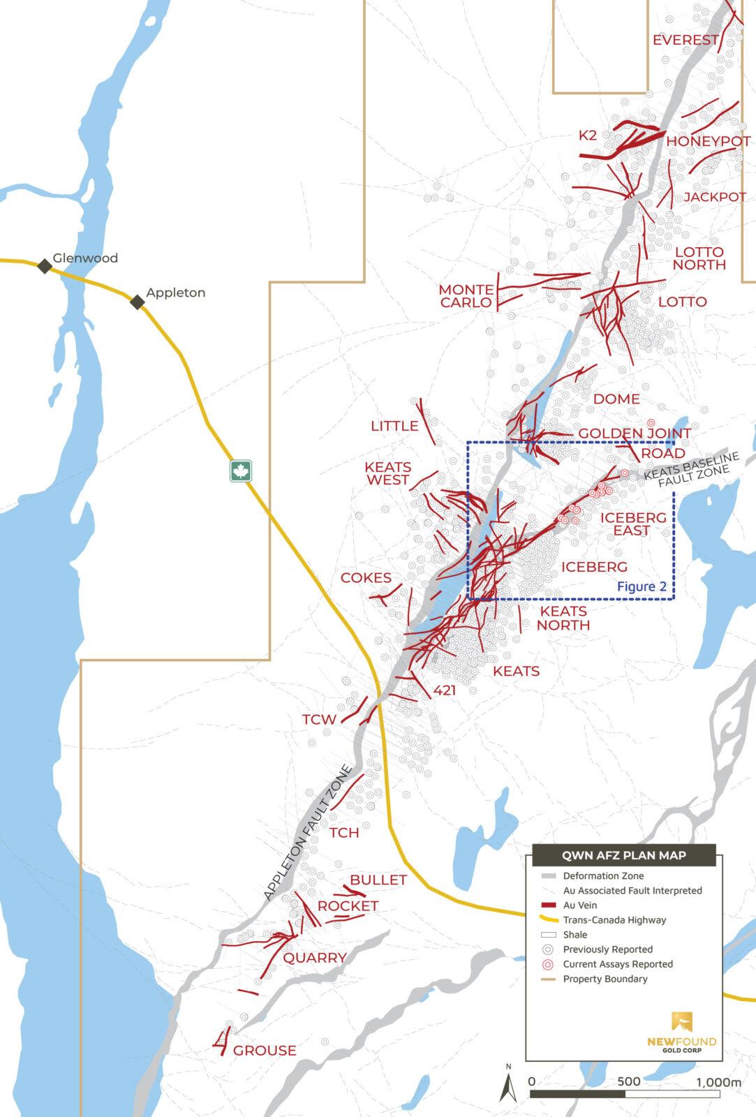
Figure 4. Grouse– Everest plan view map (Graphic: Business Wire)
Critical Metals Corp. (Nasdaq: CRML) a leading critical minerals ... READ MORE
Holes SH26-22 and SH26-23 return up to 930 g/t AgEq within broade... READ MORE
Pasinex Resources Limited (CSE: PSE) (FSE: PNX) a growing zinc-fo... READ MORE
Aya Gold & Silver Inc. (TSX: AYA; NASDAQ: AYA) is pleased to... READ MORE
New Break Resources Ltd. (CSE: NBRK) (OTCQB: NBRKF) (FSE: O91) ha... READ MORE


