








North Zone Extended by 85 m; Initial MZ Zone Drilling Intersects Broad Hydrothermal Alteration 500 m West of Mirado; Regional Drilling Permit Secured Across KL South
Kirkland Lake Discoveries Corp. (TSX-V: KLDC) (OTCQB: KLKLF) reports assay results from eight additional drill holes at the Mirado Gold Project, including broad near-surface mineralization, high-grade gold below the historical resource and an extension of the North Zone. The Company has also completed its first regional test at the MZ Zone, approximately 500 m west of Mirado, where drilling intersected intense hydrothermal alteration and sulphide mineralization. Assays from the MZ Zone are pending. KLDC has received a regional drilling permit covering all of the KL South Project.
Highlights
“Today’s results are important as they demonstrate growth in three dimensions at KL South,” said Stefan Sklepowicz, Chief Executive Officer of KLDC. “KLM26-019 materially expands the broad near-surface mineralized footprint, KLM26-017 confirms high-grade structures below the historical resource, and KLM26-013 extends the North Zone. Just as importantly, the alteration and sulphide mineralization encountered in our first regional hole at the MZ Zone, provides an early indication that the prospective hydrothermal corridor may extend well beyond the historical deposit footprint. With a regional permit in hand and 16 holes awaiting assays, we have multiple opportunities to make new discoveries and continue expanding the system.”
Mirado Gold System Expands Laterally and Vertically
Drilling along the westernmost fence of the South Zone has materially expanded the near-surface mineralized footprint and supports KLDC’s emerging “shatter-and-fill” interpretation for Mirado. Holes KLM26-012, KLM26-015, KLM26-016 and KLM26-019 intersected broad, lower-grade gold-bearing envelopes containing localized higher-grade intervals, consistent with structurally prepared, intensely silicified rock that was subsequently fractured and mineralized. Highlights include 0.50 g/t Au over 91.0 m in KLM26-019, including 1.13 g/t Au over 23.8 m and 10.94 g/t Au over 0.8 m, as well as 1.33 g/t Au over 5.5 m and 0.77 g/t Au over 18.0 m in KLM26-015. KLM26-016 returned 0.35 g/t Au over 28.0 m, including 3.16 g/t Au over 1.0 m, while KLM26-012 intersected several additional near-surface mineralized intervals.
Farther south in the South Zone, KLM26-017 and KLM26-018 extend the tested mineralized system vertically below the historical resource. KLM26-017 intersected 18.99 g/t Au over 6.7 m, including 125.91 g/t Au over 1.0 m, together with additional high-grade intervals higher in the hole. KLM26-018 intersected gold mineralization at approximately 387 m downhole, supporting the continued presence of mineralized structures at depth.
At the North Zone, KLM26-013 stepped-out 85 m west from the current drilling pattern and intersected 0.98 g/t Au over 35.0 m, including 12.20 g/t Au over 1.0 m, followed by 0.61 g/t Au over 23.0 m. The result extends the mineralized trend and supports continuity beyond the previously tested North Zone footprint (see Figure 1, Table 1, and Figure 2).
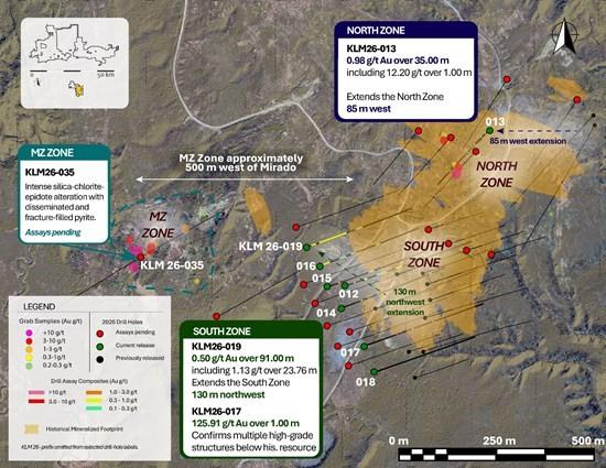
Figure 1 – Plan map of the Mirado and MZ zones showing 2026 drilling, gold assay composites, historical surface sampling and the historical mineralized footprint.
Table 1 – Drill Results
| Drill Hole | From (m) | To (m) | Interval (m) | Au (g/t) | Zone |
| KLM26-012 | 31.34 | 33.00 | 1.66 | 0.50 | South Zone |
| and | 67.71 | 76.14 | 8.43 | 0.34 | South Zone |
| and | 108.00 | 113.43 | 5.43 | 0.30 | South Zone |
| and | 127.82 | 142.34 | 14.52 | 0.35 | South Zone |
| and | 173.00 | 194.40 | 21.40 | 0.36 | South Zone |
| including | 177.00 | 177.70 | 0.70 | 2.95 | South Zone |
| KLM26-013 | 52.00 | 87.00 | 35.00 | 0.98 | North Zone |
| including | 86.00 | 87.00 | 1.00 | 12.20 | North Zone |
| and | 100.00 | 123.00 | 23.00 | 0.61 | North Zone |
| and | 148.00 | 157.00 | 9.00 | 0.32 | North Zone |
| KLM26-014 | 78.00 | 80.50 | 2.50 | 0.48 | South Zone |
| and | 126.00 | 128.90 | 2.90 | 0.49 | South Zone |
| KLM26-015 | 38.40 | 43.90 | 5.50 | 1.33 | South Zone |
| including | 38.40 | 39.00 | 0.60 | 5.78 | South Zone |
| including | 43.40 | 43.90 | 0.50 | 6.46 | South Zone |
| and | 156.00 | 174.00 | 18.00 | 0.77 | South Zone |
| KLM26-016 | 10.60 | 38.60 | 28.00 | 0.35 | South Zone |
| including | 37.60 | 38.60 | 1.00 | 3.16 | South Zone |
| and | 81.45 | 100.00 | 18.55 | 0.32 | South Zone |
| and | 168.30 | 174.70 | 6.40 | 0.36 | South Zone |
| KLM26-017 | 65.20 | 72.20 | 7.00 | 0.37 | South Zone |
| and | 115.70 | 116.65 | 0.95 | 2.11 | South Zone |
| and | 149.30 | 151.30 | 2.00 | 3.56 | South Zone |
| and | 164.85 | 171.50 | 6.65 | 18.99 | South Zone |
| including | 164.85 | 165.85 | 1.00 | 125.91 | South Zone |
| KLM26-018 | 387.00 | 388.50 | 1.50 | 0.66 | South Zone |
| KLM26-019 | 20.74 | 27.00 | 6.26 | 0.90 | South Zone |
| and | 52.00 | 143.00 | 91.00 | 0.50 | South Zone |
| including | 72.00 | 95.76 | 23.76 | 1.13 | South Zone |
| including | 95.00 | 95.76 | 0.76 | 10.94 | South Zone |
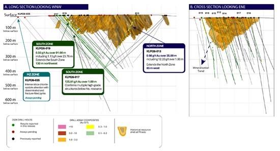
Figure 2 – Simplified cross-section and long-section views of drilling at Mirado. The historical mineralized shell is shown in orange, with current release drill holes highlighted in green and drill assay composites coloured by gold grade.
Initial MZ Drilling Intersects Broad Hydrothermal Alteration 500 m West of Mirado
The Company has commenced drilling on regional targets with compelling geophysical anomalies and historical work indicating the potential for additional zones of mineralization. At the MZ Zone, approximately 500 m west of the historical Mirado deposit, KLM26-035 intersected a broad hydrothermal system characterized by intense chlorite, silica, and epidote alteration with disseminated and fracture-filled pyrite mineralization (see Figure 3). The alteration assemblage, sulphide distribution and quartz-carbonate vein textures are visually comparable to those associated with the broad mineralized intervals in KLM26-001, which returned 5.66 g/t Au over 18.2 m, including 23.03 g/t Au over 4.3 m, and in KLM26-002, which returned 1.01 g/t Au over 121 m (see press releases dated April 16, 2026 and April 23, 2026)
The recurrence of this distinctive alteration and sulphide-mineralization style at the MZ Zone suggests that the prospective hydrothermal corridor may extend well beyond the historical Mirado footprint. Assays from KLM26-035 are pending, and visual observations are not necessarily indicative of gold grade.
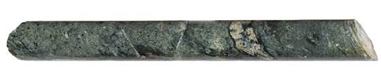
Figure 3 – KLM26-035 at approximately 195 m downhole, featuring intense chlorite, silica and epidote alteration with disseminated and fracture-filled pyrite.
Refined Geological Model Provides New Vectors for High-Grade Targeting
Recent geophysical interpretation, hyperspectral core scanning and geochemical analysis have refined KLDC’s geological model for Mirado. The integrated data supports interpretation of a structurally controlled, multi-stage hydrothermal system in which high-grade gold is associated with intense silicification, chlorite alteration, sulphide enrichment, and cross-cutting vein development.
Hyperspectral scanning of KLM26-004 identified a broad white-mica-sericite and chlorite alteration assemblage, with localized carbonate development and variations in alteration intensity through the South Zone. These mineralogical changes correspond with increasing sodium depletion, sulphur and iron enrichment and localized copper and silver enrichment approaching the strongest gold-bearing portion of the 45.41-69.39 m mineralized agglomerate interval. The relationship supports a model in which a broad sericite-chlorite alteration envelope surrounds narrower zones of silicification, sulphidation and quartz-pyrite ± chalcopyrite veining and replacement, providing a larger targeting footprint than gold assays alone.
View the High-Resolution Hyperspectral Core Scan
Figure 4 – High-Resolution Hyperspectral Core Scan and Gold Assay Profile (Drill Hole KLM26-004) Figure 4 presents true-colour core photography, hyperspectral mineral mapping, alteration intensity and corresponding gold assays. The integrated profile illustrates how shifts in silica, chlorite and white-mica alteration correspond with sulphide development and the strongest gold-bearing intervals.
How the Shatter-and-Fill Model Guides Exploration
This structural and alteration model shares selected characteristics with mineralized systems elsewhere in the Abitibi, including the Doyon-Bousquet-LaRonde and Kirkland Lake gold camps. These analogues provide geological context but do not imply that Mirado will achieve comparable scale or grade.
Together, these observations support a broader and more continuous exploration model for KL South than is represented by the historical mineralized footprint at Mirado and provides a framework for ongoing drill targeting (see Figure 5A and 5B)
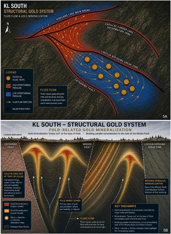
Figure 5A-B – Conceptual geological model for the KL South structural gold system. (A) Plan view illustrating the interpreted movement of mineralizing fluids from higher-pressure regional structures into a lower-pressure corridor between the Catharine Fault and the Lincoln-Nipissing Shear Zone, where structural complexity may have created favourable sites for gold deposition. (B) Conceptual cross-sectional view illustrating interpreted up-dip fluid migration, with higher-grade gold preferentially developing in dilated fold-hinge and structural trap settings west of the Mirado Fault and more bedding-parallel mineralization to the east. These conceptual models illustrate KLDC’s current geological interpretation and are not representations of known mineralization outside areas supported by drilling.
Digital Resources
Stakeholders can explore KLDC’s drilling through a publicly accessible interactive 3D model hosted by Mining Hub, which illustrates drill-hole data, mineralized intervals and interpreted target areas. The latest episode of KLDC’s Treasure Hunters video series also provides an on-site update on drilling, exploration progress and infrastructure improvements at KL South. CEO Stefan Sklepowicz discusses the latest results and the ongoing Mirado drill program.
Cannot view this video? Visit:
https://www.youtube.com/watch?v=rj6taNjONDo
Data Verification & Quality Assurance/Quality Control
Gold analyses were completed on ½ NQ Core at Paragon Geochemical using Chrysos PhotonAssay™ technology, a fast, non-destructive analytical method that utilizes high-energy X-rays to directly measure gold content in large (~500 g) samples. The larger sample mass used in PhotonAssay is designed to reduce sampling variability associated with coarse gold mineralization and provides rapid, non-destructive gold analysis while also enabling faster turnaround times.
Table 2 – Paragon Sample Preparation and Analytical Methods
| Analysis | Code | Locations |
| Preparation | PREP-PKG | Timmins, Ontario, Canada |
| Photon and Fire Assay | PA-AU01, Au-SCR1K | Surrey, British Columbia Hamilton, Ontario, Canada |
| Multi-Element | 33MA-OES | Sparks, Nevada, USA |
Samples returning gold values above the 350 g/t upper detection limit of the PhotonAssay method are reanalyzed using a 1 kg screen fire assay, wherein the sample is sieved at 110 microns, the coarse (+) fraction is analyzed by gravimetric methods, and the fine (-) fraction is analyzed in duplicate by AAS, with the combined results providing a representative total gold value, particularly in samples containing coarse gold.
Drill program design, QA/QC, and interpretation of results are conducted by qualified persons consistent with National Instrument 43-101 and industry best practices. Certified reference standards and blanks are inserted into the sample stream at regular intervals, approximately one control sample per twenty samples, to monitor analytical accuracy and precision.
Reported intervals are calculated using a weighted average grade with a 0.2 g/t Au cutoff. To reflect the continuity of mineralization within the broader system, up to 6.9 m of internal dilution (consecutive material below cutoff) is included within reported composites. Reported assays are uncut and no top cut has been applied. True widths are estimated at approximately 80% of reported core lengths.
Qualified Person
The technical information contained in this news release has been reviewed and approved by Benjamin Cleland, P.Geo., Vice-President Exploration, who is a Qualified Person as defined by National Instrument 43-101 – Standards of Disclosure for Mineral Projects.
About Kirkland Lake Discoveries Corp.
Kirkland Lake Discoveries Corp. has assembled a 420-km² exploration portfolio in the Kirkland Lake region of Ontario’s Abitibi Greenstone Belt, one of the most prolific mining districts in the world. The Company’s properties span key fault zones, geophysical anomalies, and volcanic-sedimentary contacts within the Blake River Group, a highly prospective assemblage known to host both gold and polymetallic massive-sulphide deposits.
With exploration permits now in place, KLDC is positioned to advance a strong pipeline of drill-ready targets at KL South, KL West and KL East, supported by multiple anomalous soil trends, historical mineral showings, and structurally controlled intersections.
Brutus Mining Inc. (CSE: BRU) (FSE: ZI3) is pleased to announce that it has closed its non-brokered ... READ MORE
Jaguar Uranium Corp. (NYSE American: JAGU) is pleased to announce an independent Mineral Resource E... READ MORE
Auro Metals Inc. (TSX-V: AURO) (OTCQB: AURFF), is pleased to announce the assay results of the fina... READ MORE
Endeavour Silver Corp. (NYSE: EXK) (TSX: EDR) is pleased to announce that repairs to the primary bal... READ MORE
Scorpio Gold Corp. (NASDAQ: SGLD) (TSX-V: SGLD) (OTCQB: SRCRF) (FSE: RY9) is pleased to announce re... READ MORE


