


Including 25.70 g/t Gold, 0.81% Zinc over 1.5 meters
HighGold Mining Inc. (TSX-V:HIGH) (OTCQX:HGGOF) is pleased to announce the third and final batch of assay results from 2022 drilling at its new Ellis Zone discovery at the Difficult Creek Prospect, located four km northeast of the Company’s 1.05 Moz indicated at 9.4 g/t gold equivalent JT Deposit. Difficult Creek is one of several district-scale prospects being explored by HighGold on the Johnson Tract project in Southcentral Alaska, USA.
Diamond drilling during the second half of the 2022 summer field season focused on systematically stepping out along strike and at depth on the Ellis Zone on 25 to 50-meter centres. The new drilling has returned strong mineralization west and down-plunge of recently released results and includes 15.5m at 4.04 g/t AuEq, including 1.5m at 26.24 g/t AuEq, in hole DC22-056, and 16.1m at 3.07 g/t AuEq, including 3.0m at 7.84 g/t AuEq, in hole DC22-060. Additional assay highlights can be found below and in Table 1 and Figures 1 and 2.
Drill Highlights of the Ellis Zone, DC Prospect
“The 2022 drill program at the Ellis Zone was very successful in sketching-in a new center of high-grade gold and base metal mineralization with similar characteristics to the main +1Moz JT Deposit located 4km away,” commented Darwin Green, CEO. “This is strong validation of the district potential for multiple deposits and the opportunity to contribute additional mineral resources to the existing resource base. To date, the Ellis Zone has been documented over a strike length of 125 meters and from surface to a depth of 225 meters and is open to expansion. It remains early days in the exploration of this promising new zone, and we look forward to returning in 2023 with larger step-outs, particularly down plunge to the west and to depth.”
Discussion of DC Prospect and Ellis Zone Drill Results
The DC Prospect is located four kilometers northeast of the JT Deposit and is characterized by a series of large gossan alteration zones similar in style to the +1Moz AuEq JT Deposit that collectively extend over a 1.5 km x 3.0 km area in a broad northeasterly trend. Gold mineralization and pervasive clay/anhydrite alteration are preferentially developed within dacitic to rhyolitic fragmental rocks that are capped by a shallowly-dipping sequence of lesser altered andesite volcanics that are host to a gold- and silver-rich epithermal vein field at higher elevations. The widespread extent of mineralization exposed in erosional windows through the capping andesite supports potential for a large and partially blind mineralized system linking the various DC Prospect zones together over a strike length of 3 km. Drilling in late 2021 resulted in the discovery of near-surface bonanza-grade mineralization, which returned 577.9 g/t Au and 2,023 g/t Ag over 6.40 meters in hole DC21-010. Subsequent geological modeling during the off-season inferred an east-west striking, steeply north-dipping trend to the mineralization that became the focus for the initial 2022 drill program at what is now referred to as the ‘Ellis Zone’.
A total of 43 drill holes for 6,056.4 meters were completed at the Difficult Creek Prospect, including 39 holes at the Ellis Zone and five (5) holes at other nearby targets. Today’s news release reports on all remaining assay results for the 2022 drill program at Difficult Creek, with new results reported for 29 holes (24 from the Ellis Zone and 5 from other nearby targets). Of particular note, are holes DC22-049/050/051/056/060 which were drilled down-dip and down-plunge from previously released hole DC22-046 which returned 14.8m at 14.3 g/t AuEq (See Company press release dated September 28, 2022) and hole DC22-043 which returned 11.9m at 21.7 g/t AuEq (See Company press releases dated September 12, 2022). The most significant of the current batch of assay results are 15.5m at 2.99 g/t Au, 1.49% Zn (4.04 g/t AuEq), including 1.5m at 25.70 g/t Au, 0.81% Zn (26.24 g/t AuEq) in hole DC22-056, and 16.1m at 0.36 g/t Au, 3.97% Zn, 0.21% Cu (3.07 g/t AuEq), including 3.0m at 0.75 g/t Au, 11.03% Zn, 0.31% Cu (7.84 g/t AuEq) in hole DC22-060. Also, of note are deep intersections in hole DC22-047 (12.9m at 1.1 g/t AuEq) and hole DC22-061 (14.0m at 1.3 g/t AuEq), 225 meters below surface (Figure 2) which represent 150-meter step outs down dip and demonstrate the system is open to depth.
Drill holes have been completed as fans of holes in a close-spaced (12.5 to 50-meter) grid pattern with the objective of defining the geometry, geological controls, and grade distribution of this significant new mineralized zone. Drilling has now defined the Ellis Zone mineralization over a strike length of 125 meters and from surface to a depth of 225 meters with an average true thickness of 10 to 15m within the plunging core of the zone. An apparent shallow plunge to the west to northwest is now implied by the higher-grade intercepts. The Ellis Zone remains open along strike to the west and down-dip/down-plunge.
Mineralogy, veining and alteration of the Ellis Zone are similar to the main JT Deposit, which has been defined from surface to a vertical depth of more than 300 meters, over a strike length of 600 meters and has an average true thickness of 40m.
Details of the locations of all 2022 drill holes can be found in Figures 1 and 2 with key assay intersections in this press release displayed in Table 1.
Table 1. Significant Assay Intersections from the Ellis Zone, Johnson Tract Project
| Drill Hole | From | To | Length | Au | Ag | Cu | Pb | Zn | AuEq |
| (meters) | (meters) | (meters) | (g/t) | (g/t) | % | % | % | (g/t) | |
| DC22-035 | 79.6 | 92.8 | 13.2 | 0.12 | 2.9 | 0.03 | 0.17 | 0.45 | 0.5 |
| DC22-036* | 41.0 | 83.8 | 42.8 | 3.44 | 23.3 | 0.21 | 0.83 | 2.06 | 5.4 |
| Incl | 42.0 | 60.4 | 18.4 | 7.29 | 49.9 | 0.44 | 1.78 | 3.92 | 11.2 |
| Incl | 47.0 | 50.7 | 3.7 | 18.00 | 86.8 | 0.91 | 1.62 | 4.05 | 22.9 |
| DC22-037 | 57.4 | 61.5 | 4.1 | 3.28 | 14.1 | 0.29 | 0.81 | 3.14 | 5.9 |
| Incl | 58.4 | 59.3 | 0.9 | 14.55 | 35.7 | 0.89 | 0.15 | 0.22 | 16.2 |
| DC22-038* | 74.6 | 82.8 | 8.2 | 4.39 | 8.7 | 0.34 | 0.03 | 0.28 | 5.1 |
| Incl | 74.6 | 80.1 | 5.5 | 5.95 | 11.9 | 0.50 | 0.01 | 0.21 | 6.8 |
| DC22-039 | NSV | ||||||||
| DC22-040 | NSV | ||||||||
| DC22-041 | 17.9 | 19.9 | 2.00 | 0.37 | 8.9 | 0.38 | 2.30 | 4.52 | 4.3 |
| And | 32.2 | 38.2 | 6.0 | 1.13 | 7.1 | 0.09 | 0.72 | 1.30 | 2.3 |
| Incl | 32.2 | 35.2 | 3.0 | 1.84 | 11.6 | 0.12 | 1.14 | 1.85 | 3.6 |
| DC22-041B | 1.4 | 3.2 | 1.8 | 1.81 | 17.2 | 0.06 | 0.06 | 0.05 | 2.1 |
| And | 17.4 | 22.1 | 4.7 | 0.13 | 7.1 | 0.26 | 1.36 | 2.35 | 2.3 |
| Incl | 20.1 | 21.1 | 1.0 | 0.36 | 15.4 | 0.72 | 2.94 | 5.36 | 5.5 |
| DC22-042 | 80.7 | 84.5 | 3.8 | 0.55 | 83.5 | 0.02 | 0.18 | 0.42 | 1.7 |
| DC22-043* | 37.1 | 49.0 | 11.9 | 21.68 | 30.1 | 0.61 | 0.38 | 4.20 | 25.3 |
| Incl | 37.1 | 43.7 | 6.6 | 38.31 | 48.8 | 0.89 | 0.37 | 5.48 | 43.3 |
| Incl | 37.1 | 41.0 | 3.9 | 54.20 | 71.1 | 1.26 | 0.48 | 8.29 | 61.6 |
| DC22-044* | 46.4 | 66.7 | 20.3 | 1.72 | 5.6 | 0.14 | 0.18 | 1.46 | 2.9 |
| Incl | 52.8 | 54.8 | 2.0 | 8.34 | 8.9 | 0.41 | 0.44 | 4.00 | 11.4 |
| DC22-045* | 4.6 | 57.1 | 52.5 | 2.95 | 5.5 | 0.10 | 1.01 | 2.38 | 4.9 |
| Incl | 9.1 | 44.3 | 35.2 | 4.20 | 6.1 | 0.12 | 1.40 | 3.19 | 6.7 |
| Incl | 9.1 | 11.0 | 1.9 | 12.95 | 37.7 | 0.08 | 13.51 | 31.42 | 36.2 |
| Incl | 30.0 | 43.3 | 13.3 | 7.81 | 6.4 | 0.23 | 1.31 | 2.35 | 10.0 |
| DC22-046* | 56.0 | 70.8 | 14.8 | 10.14 | 13.8 | 0.28 | 0.46 | 5.97 | 14.3 |
| Incl | 56.0 | 65.7 | 9.7 | 15.34 | 20.0 | 0.42 | 0.60 | 8.58 | 21.3 |
| Incl | 57.5 | 64.3 | 6.8 | 21.29 | 25.1 | 0.55 | 0.61 | 10.70 | 28.7 |
| Incl | 57.5 | 59.0 | 1.5 | 62.50 | 10.5 | 0.77 | 0.59 | 10.50 | 70.0 |
| DC22-047 | 97.8 | 159.1 | 61.3 | 0.19 | 0.4 | 0.05 | 0.06 | 1.02 | 0.9 |
| Incl | 145.5 | 149.3 | 3.8 | 0.51 | 2.1 | 0.38 | 0.01 | 5.42 | 4.2 |
| And | 264.0 | 276.9 | 12.9 | 0.08 | 3.1 | 0.73 | 0.01 | 0.11 | 1.1 |
| Incl | 274.7 | 276.2 | 1.5 | 0.20 | 5.7 | 2.66 | 0.01 | 0.07 | 3.7 |
| DC22-048 | 80.2 | 88.6 | 8.4 | 0.20 | 2.3 | 0.21 | 0.20 | 1.27 | 1.3 |
| Incl | 84.5 | 85.7 | 1.2 | 0.51 | 7.9 | 1.03 | 0.91 | 3.21 | 4.1 |
| And | 129.0 | 137.4 | 8.4 | 0.10 | 4.4 | 0.35 | 0.03 | 2.08 | 1.8 |
| Incl | 129.0 | 131.4 | 2.4 | 0.25 | 12.7 | 1.20 | 0.04 | 4.87 | 4.8 |
| DC22-049 | 55.7 | 62.3 | 6.6 | 1.43 | 13.4 | 0.62 | 0.13 | 4.35 | 5.0 |
| Incl | 59.6 | 60.9 | 1.3 | 5.70 | 54.9 | 2.55 | 0.19 | 5.68 | 12.9 |
| And | 72.9 | 76.2 | 3.3 | 0.39 | 4.9 | 0.23 | 0.09 | 3.29 | 2.7 |
Table 1 Continued.
| Drill Hole | From | To | Length | Au | Ag | Cu | Pb | Zn | AuEq |
| (meters) | (meters) | (meters) | (g/t) | (g/t) | % | % | % | (g/t) | |
| DC22-050 | 52.8 | 68.9 | 16.1 | 0.17 | 2.3 | 0.05 | 0.16 | 2.08 | 1.5 |
| Incl | 62.9 | 63.4 | 0.5 | 0.76 | 9.9 | 0.43 | 0.03 | 32.50 | 20.6 |
| DC22-051 | 76.4 | 80.0 | 3.6 | 0.90 | 3.1 | 0.21 | 0.17 | 7.91 | 5.9 |
| Incl | 77.6 | 79.1 | 1.5 | 1.91 | 3.3 | 0.29 | 0.33 | 12.75 | 9.9 |
| DC22-052** | NSV | ||||||||
| DC22-053** | 27.5 | 29.2 | 1.7 | 0.47 | 9.4 | 0.18 | 0.65 | 2.30 | 2.4 |
| DC22-054** | NSV | ||||||||
| DC22-055** | NSV | ||||||||
| DC22-056 | 71.3 | 86.8 | 15.5 | 2.99 | 6.4 | 0.06 | 0.12 | 1.49 | 4.0 |
| Incl | 79.8 | 81.3 | 1.5 | 25.70 | 3.5 | 0.01 | 0.03 | 0.81 | 26.2 |
| DC22-057 | 72.9 | 75.4 | 2.5 | 0.74 | 2.9 | 0.11 | 0.05 | 7.10 | 5.1 |
| Incl | 72.9 | 74.4 | 1.5 | 1.01 | 3.7 | 0.12 | 0.06 | 10.25 | 7.3 |
| DC22-058 | 29.2 | 30.7 | 1.5 | 0.04 | 296.0 | 0.05 | 0.58 | 1.30 | 4.0 |
| And | 62.6 | 68.6 | 6.0 | 0.49 | 1.8 | 0.02 | 0.12 | 0.63 | 0.9 |
| And | 79.1 | 85.0 | 5.9 | 0.82 | 0.9 | 0.00 | 0.15 | 0.61 | 1.2 |
| DC22-059 | 57.9 | 65.3 | 7.4 | 0.41 | 1.8 | 0.03 | 0.14 | 1.69 | 1.5 |
| Incl | 61.1 | 64.3 | 3.2 | 0.55 | 1.5 | 0.04 | 0.18 | 2.67 | 2.3 |
| DC22-060 | 53.1 | 69.2 | 16.1 | 0.36 | 4.7 | 0.21 | 0.19 | 3.97 | 3.1 |
| Incl | 57.8 | 60.8 | 3.0 | 0.75 | 6.4 | 0.31 | 0.42 | 11.03 | 7.8 |
| DC22-061 | 198.0 | 212.0 | 14.0 | 0.15 | 3.0 | 0.62 | 0.00 | 0.46 | 1.3 |
| Incl | 199.5 | 201.9 | 2.4 | 0.50 | 9.6 | 1.67 | 0.00 | 0.76 | 3.2 |
| DC22-062 | 44.1 | 49.1 | 5.0 | 0.24 | 3.6 | 0.03 | 0.24 | 1.08 | 1.0 |
| And | 67.3 | 68.8 | 1.5 | 5.82 | 1.4 | 0.00 | 0.02 | 0.13 | 5.9 |
| DC22-063 | 46.4 | 48.4 | 2.0 | 0.26 | 18.7 | 0.06 | 0.79 | 1.76 | 1.8 |
| DC22-064 | 33.4 | 39.3 | 5.9 | 0.76 | 2.4 | 0.07 | 0.58 | 1.35 | 1.9 |
| Incl | 33.4 | 35.0 | 1.6 | 2.23 | 5.2 | 0.13 | 0.86 | 2.08 | 4.0 |
| And | 48.0 | 51.1 | 3.1 | 0.55 | 3.1 | 0.05 | 0.18 | 1.25 | 1.4 |
| DC22-065 | 4.2 | 31.5 | 27.3 | 0.77 | 2.7 | 0.02 | 0.24 | 0.55 | 1.2 |
| Incl | 19.3 | 27.8 | 8.5 | 1.41 | 3.6 | 0.03 | 0.69 | 1.55 | 2.6 |
| And | 38.7 | 56.4 | 17.7 | 0.62 | 3.6 | 0.15 | 0.15 | 0.92 | 1.4 |
| Incl | 46.7 | 48.9 | 2.2 | 2.20 | 15.1 | 0.74 | 0.01 | 0.53 | 3.6 |
| And | 82.7 | 85.0 | 1.5 | 0.81 | 54.1 | 0.52 | 1.30 | 4.45 | 5.0 |
| DC22-066 | NSV | ||||||||
| DC22-067 | NSV | ||||||||
| DC22-068** | NSV | ||||||||
| Notes: | |||||||||
| * Previously released drill intersection | |||||||||
| ** Other Difficult Creek Targets (not Ellis Zone) | |||||||||
| NSV = No significant values | |||||||||
| True thickness for the reported intersections estimated at 50% to 90% of reported width. Gold Equivalent (“AuEq”) based on assumed metal prices of US$1650/oz for Au, US$20/oz for Ag, US$3.50/lb for Cu, US$1.00/lb for Pb and US$1.50/lb for Zn and payable metal recoveries of 97% for Au, 85% for Ag, 85% Cu, 72% Pb and 92% Zn. | |||||||||
About the Johnson Tract Gold Project
Johnson Tract is a polymetallic (gold, copper, zinc, silver, lead) project located near tidewater, 125 miles (200 kilometers) southwest of Anchorage, Alaska, USA. The 21,000-acre property includes the high-grade JT Deposit and at least nine (9) other mineral prospects over a 12-kilometer strike length. HighGold acquired the Project through a lease agreement with Cook Inlet Region, Inc. (“CIRI”), one of 12 land-based Alaska Native regional corporations created by the Alaska Native Claims Settlement Act of 1971. CIRI is owned by more than 9,100 shareholders who are primarily of Alaska Native descent.
Mineralization at Johnson Tract occurs in Jurassic intermediate volcaniclastic rocks and is characterized as epithermal-type with submarine volcanogenic attributes. The JT Deposit is a thick, steeply dipping silicified body averaging 40m true thickness that contains a stockwork of quartz-sulphide veinlets and brecciation, cutting through and surrounded by a widespread zone of anhydrite alteration. The Footwall Copper Zone is located structurally and stratigraphically below JT Deposit and is characterized by copper-silver rich mineralization.
The JT Deposit hosts an Indicated Resource of 3.489 Mt grading 9.39 g/t gold equivalent comprised of 5.33 g/t Au, 6.0 g/t Ag, 0.56% Cu, 0.67% Pb and 5.21% Zn. The Inferred Resource of 0.706 Mt grading 4.76 g/t AuEq is comprised of 1.36 g/t Au, 9.1 g/t Ag, 0.59% Cu, 0.30% Pb, and 4.18% Zn. For additional details see NI 43-101 Technical Report titled “Updated Mineral Resource Estimate and NI 43-101 Technical Report for the Johnson Tract Project, Alaska,” dated August 25, 2022 (effective date of July 12, 2022) authored by Ray C. Brown, James N. Gray, P.Geo. and Lyn Jones, P.Eng. Gold Equivalent is based on assumed metal prices and payable metal recoveries of 97% for Au, 85% for Ag, 85% Cu, 72% Pb and 92% Zn from metallurgical testwork completed in 2022. Assumed metal prices for the Resource are US$1650/oz for gold, US$20/oz for silver, US$3.50/lb for copper, US$1.00/lb for lead, and US$1.50/lb for zinc.
About HighGold
HighGold is a mineral exploration company focused on high-grade gold projects located in North America. HighGold’s flagship asset is the high-grade Johnson Tract Gold-Zinc-Copper Project located in accessible Southcentral Alaska, USA. The Company also controls one of the largest junior gold miner land positions in the Timmins, Ontario gold camp. This includes the Munro-Croesus Gold property, which is renowned for its high-grade mineralization, and the large Golden Mile and Timmins South properties. HighGold also has 100% ownership of a group of properties in Yukon’s emerging new Selwyn Basin Reduced Intrusive Related Gold district. HighGold’s experienced Board and senior management team, are committed to creating shareholder value through the discovery process, careful allocation of capital, and environmentally/socially responsible mineral exploration.
Ian Cunningham-Dunlop, P.Eng., Senior VP Exploration for HighGold Mining Inc. and a qualified person as defined by Canadian National Instrument 43-101, has reviewed and approved the technical information contained in this release.
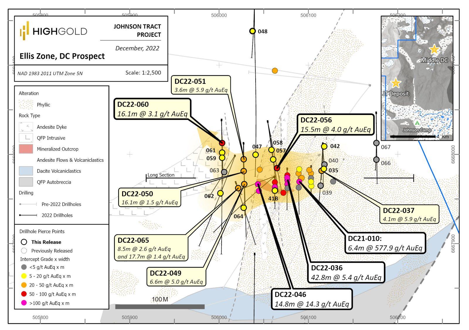
Figure 1. Ellis Zone, Johnson Tract Project – Plan Map with Drill Hole Locations (Graphic: Business Wire)
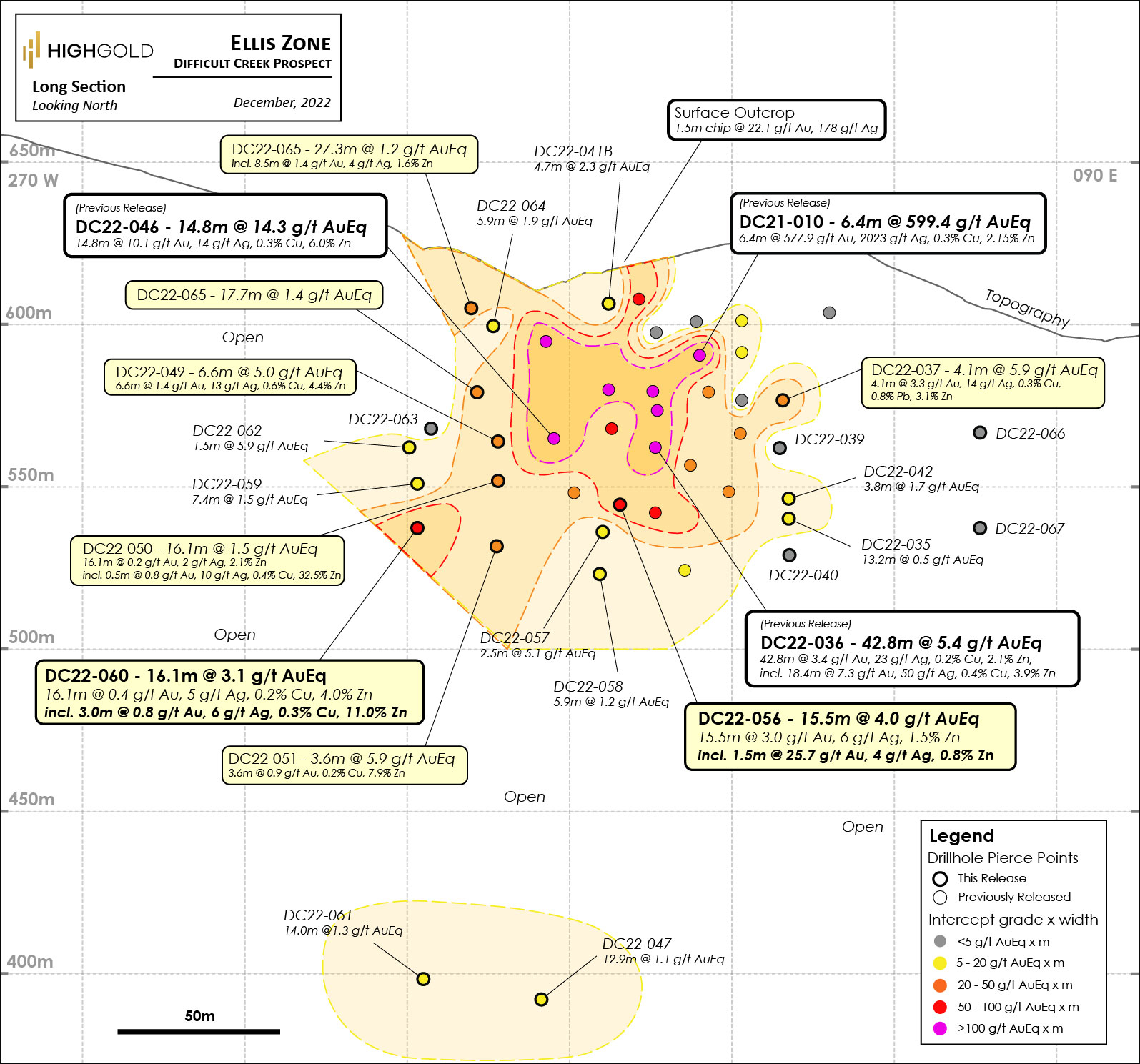
Figure 2. Ellis Zone, Johnson Tract Project – Vertical Longitudinal Section with Drill Intersections (Graphic: Business Wire)
F4 Uranium Crop. (TSX-V: FFU) is pleased to announce the closing ... READ MORE
Peruvian Metals Corp. (TSX-V: PER) (OTC Pink: DUVNF) is pleased t... READ MORE
Lion One Metals Limited (TSX-V: LIO) (OTCQX: LOMLF) is pleased to... READ MORE
GoGold Resources Inc. (TSX: GGD) (OTCQX: GLGDF) is pleased to rep... READ MORE
Emerita Resources Corp. (TSX-V: EMO) (OTCQB: EMOTF) (FSE: LLJA) r... READ MORE


