








– Highlights include 15.0 m grading 2.89 g/t gold equivalent (AuEQ) within 25.5 m grading 1.97 g/t AuEQ, all within broader mineralized intervals of 300 m grading 0.43 g/t AuEQ and 407.55 m grading 0.39 g/t AuEQ
Goldstorm Metals Corp. (TSX-V: GSTM) (FSE: B2U) is pleased to announce the assay results from the first three drill holes of the recently completed diamond drill program on its 100%-owned Crown gold-silver-copper property, located in the Golden Triangle region of British Columbia. Crown is situated to the south of Newmont Corporation’s Brucejack Mine and Seabridge Gold Inc.’s KSM Property. Click to view the location map.
The Phase I diamond drilling program comprised seven holes totaling 4,155.5 meters (m) that tested a portion of the Copernicus gold-silver-copper geochemical trend, which coincides with a 1.2-kilometre-long induced polarization (“IP”) chargeability anomaly. Analytical results from the remaining four drill holes are pending and will be reported by the Company once the data has been received, compiled and interpreted.
Highlights
Ken Konkin P. Geo., President and CEO comments: “I am very pleased to announce that Goldstorm’s preliminary drilling program has discovered a very large precious metals system that appears to be on trend with the KSM and Treaty Creek deposits to the north. Significant precious metal mineralization intersected in the drill holes is associated with pervasive strong silicification that is believed to be linked to structural features that trend southward from the multiple, large, porphyry gold-silver-copper deposits at KSM and Treaty Creek.
The Orion Spine, where this mineralization has been discovered, is located between two arms of the Frank Mackie Glacier and is well exposed. Clearly this resistant ridgeline withstood the effects of glacial erosion due to the siliceous and resistive nature of the altered rocks. The strongly silicified, rhyolitic-dacitic volcanic flows and tuffs intersected in the drilling are well brecciated and mineralized with base-metal sulphides, acanthite (silver sulphide) and gold.
Our geologists believe that deeper in the volcanic pile, we may encounter the intrusive-related source that provided well-mineralized hydrothermal fluids and may have developed into a large porphyry system. The favorable mineralized horizons at KSM and Treaty Creek are much lower in the pile than the drill area at the higher elevation Orion Spine, giving this project excellent geological potential for discovery of a very large bulk-tonnage deposit at depth. We are currently awaiting the results from 24 sample shipments and will continue to release results from the rest of the reconnaissance program, as well as the last four drill holes, as we receive them. We are excited about our preliminary drilling results and are already planning an expanded drilling program at the Crown project for next year.”
Table 1: Crown Property Drilling, Assay Results for Holes 1-3
| Hole | From | To | Interval (m) |
AuEQ (g/t) (3) | Au (g/t) | Ag (g/t) |
| OR-26-01 (1) | – | – | – | No Significant Values | ||
| OR-26-02 | 325.1 | 339.0 | 13.9 | 0.80 | 0.02 | 51.5 |
| including | 331.1 | 338.15 | 7.05 | 1.30 | 0.02 | 84.2 |
| including | 333.4 | 337.1 | 3.7 | 2.07 | 0.02 | 135.5 |
| OR-26-03 | 114.45 | 522.0 | 407.55 | 0.39 | 0.11 | 18.3 |
| including | 222.0 | 522.0 | 300.0 | 0.43 | 0.14 | 18.7 |
| including | 222.0 | 301.5 | 79.5 | 0.77 | 0.13 | 42.6 |
| including | 222.0 | 247.5 | 25.5 | 1.97 | 0.28 | 111.5 |
| including | 222.0 | 237.0 | 15.0 | 2.89 | 0.37 | 166.7 |
| and | 474.0 | 480.0 | 6.0 | 1.63 | 0.25 | 90.6 |
| and | 502.5 | 505.5 | 3.0 | 1.15 | 1.09 | 4.2 |
| * Notes: (1) Hole was lost after encountering a large void at 98 m (2) All assay values are uncut, and intervals reflect drilled intercept lengths. (3) Assumptions for the gold equivalent calculation used a metal ratio of 66 for Au price/Ag price, determined from average metal prices over the past 3 months. No current or historical metallurgical work has been completed; therefore, recoveries are assumed to be 85% for gold, and 85% for silver, based on metallurgical test results for mineralization at the nearby Treaty Creek property. The following equation was used to calculate the gold equivalence: AuEq = gold (g/t) + [silver (g/t) x (Ag price/Au price) x (Ag recovery/Au recovery)]. Differences may occur due to rounding. Gold equivalent values are provided for comparison purposes only and are not a statement of recoverable metal. The assumed recoveries of 85% for each of gold and silver are not supported by any metallurgical testing on the Crown Project, no metallurgical test work has been completed, and actual recoveries may differ materially from those assumed. (4) True widths have not been determined as the mineralized body remains open in all directions. Further drilling is required to determine the mineralized body orientation and true widths. (5) HQ and NQ diameter core samples were cut in half and typically sampled at standard 1.5-meter intervals. |
||||||
Table 2: Crown Property Drill Orientation Data for Holes 1-3
| HOLE ID | Easting | Northing | Elevation | Azimuth | Dip | Depth (m) |
| OR-26-01 | 422736 | 6247732 | 1586 | 75 | -50 | 98 |
| OR-26-02 | 422736 | 6247732 | 1586 | 75 | -60 | 693 |
| OR-26-03 | 422736 | 6247732 | 1586 | 255 | -65 | 627 |
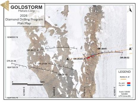
Figure 1. Plan Map – 2026 Crown Drill Locations and Holes 1 to 3 Graphical Au, Ag Values
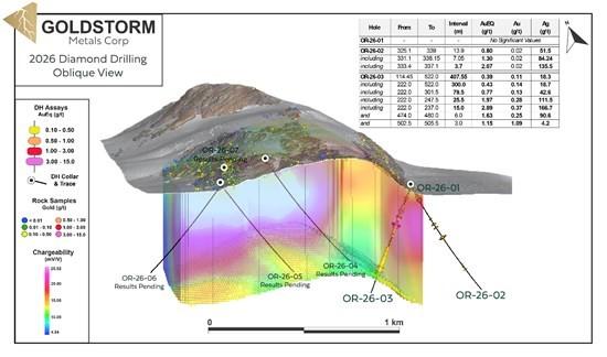
Figure 2. Cross Section – 2026 Orion Area Chargeability with Holes 1-3 Drilling Results
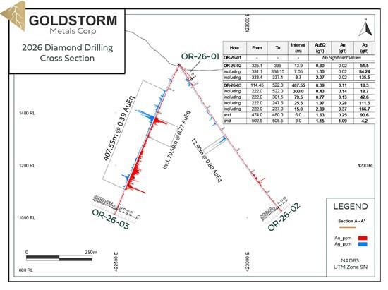
Figure 3. – Orion Cross Section – Holes 1, 2 and 3
Qualified Person
The Qualified Person for this news release for the purposes of National Instrument 43-101 is the Company’s President and CEO, Ken Konkin, P.Geo. He has read and approved the scientific and technical information that forms the basis for the disclosure contained in this news release.
QA/QC
All samples were prepared at MSA Labs’ Preparation Laboratory in Terrace, BC and assayed at MSA Labs’ Geochemical Laboratory in Langley, BC. Gold was assayed using a fire assay with atomic absorption (AA) spectrometry finish. Samples over 10 ppm gold were fire assayed with gravimetric finish. All samples were analyzed by four acid digestion with multi-element ICP-MS, with silver and base metal over-limits being reanalyzed by emission spectrometry. MSA Laboratories quality system complies with the requirements for the International Standards ISO 17025 and ISO 9001. MSA Labs is independent of the Company.
About Goldstorm Metals
Goldstorm Metals Corp. is a precious and base metals exploration company with a large strategic land position in the Golden Triangle of British Columbia, an area that hosts some of the largest and highest-grade gold deposits in the world. Goldstorm’s flagship projects, Crown and Electrum, cover an area that totals 16,469 hectares over 6 concessions, of which 5 are contiguous. The Crown Project is situated directly south of Seabridge Gold’s KSM gold-copper deposits and Newmont Corporation’s Brucejack/Valley of the Kings gold mine. Electrum, also located in the Golden Triangle of BC, is situated directly between Newmont Corporation’s Brucejack Mine, approximately 20 kilometers to the north, and the past producing Silbak Premier mine, 20 kilometers to the south.
Intersected a new mineralized structure above previously defined ... READ MORE
Canoe Mining Ventures Corp. (TSX-V: CLV) is pleased to announce... READ MORE
HIGHLIGHTS 49 holes and 10,018 metres drilled, two and a half tim... READ MORE
High-Grade Oxide Gold Zone Extends Beyond Current Mineral Resourc... READ MORE
Cerro de Pasco Resources Inc. (TSX-V CDPR) (OTCQX CDPMF) (FRA N8H... READ MORE