


Gold79 Mines Ltd. (TSX-V: AUU) (OTCQB: AUSVF) is pleased to announce additional results from its recently completed 16 hole drill program at the Gold Chain project in western Arizona. The remaining 12 holes (852 meters) highlighted in this release were focused on the northwestern-most 2 kilometers of the 10 km North Oatman trend which includes the historical Roadside mine and the Banner mine to the southeast (Figure 1).
Highlights
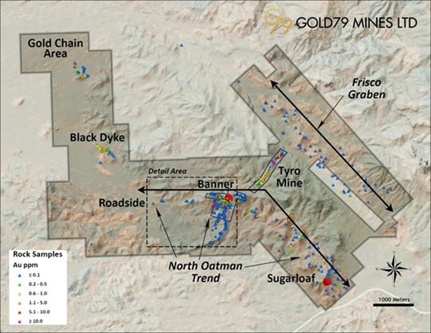
Figure 1. Gold Chain project area showing prospects and surface rock samples (gold)
Mr. Derek Macpherson, President & CEO stated, “I consider our maiden drill program at Gold Chain to be a huge success. These results demonstrate economic grades over 2km of the 10km North Oatman trend. Our previously released results from Tyro (see Oct. 25, 2021, press release) returned broad zones of shallow mineralization at good grades.” Mr. Macpherson continued, “We plan to follow-up this drill program with additional drilling, further sampling, mapping along the trend and geophysics as we work towards generating a maiden resource at Gold Chain.”
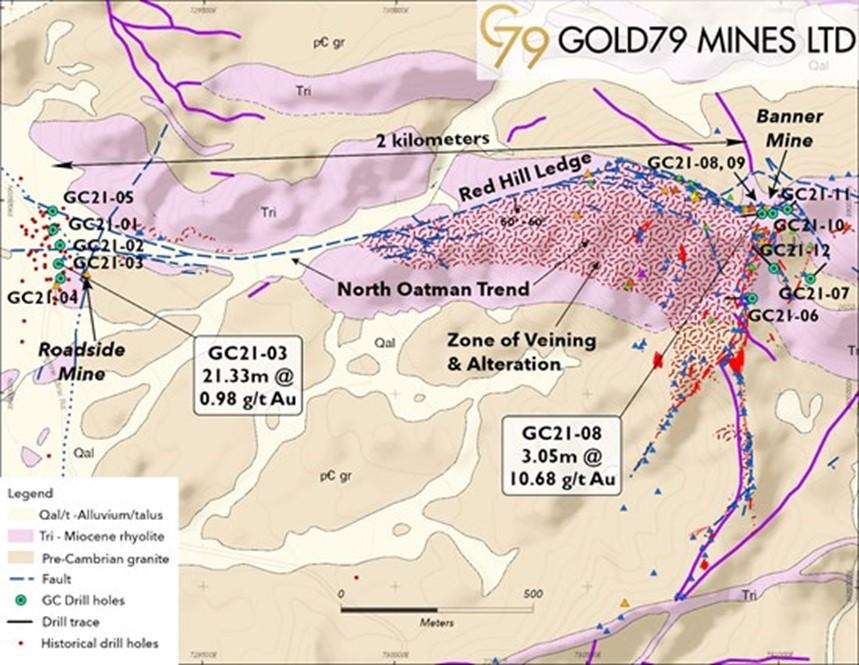
Figure 2. Generalized geologic map (after Murphy and Faulds, 2013) of the Roadside – Banner mine area showing the Red Hill Ledge and drill holes
Table 1: Summary of Drill Holes GC21-01 to -05 (Roadside mine prospect) and GC21-06 to -12 (Banner mine).
| Target | Hole No. | Total Hole Depth (m) | Interval (m) | Width (m) | Gold (g/t) | |
| From | To | |||||
| Roadside Mine | GC21-01 | 61.0 | 3.0 | 6.1 | 3.1 | 0.04 |
| Roadside Mine | GC21-02 | 61.0 | 22.8 | 29.0 | 6.2 | 0.62 |
| Roadside Mine | GC21-03 | 67.1 | 21.3 | 42.7 | 21.3 | 0.98 |
| Roadside Mine | GC21-04 | 70.1 | 51.8 | 64.0 | 12.2 | 0.04 |
| Red Hill Ledge | GC21-08 | 107.1 | 33.5 | 36.5 | 3.1 | 10.68 |
| Red Hill Ledge | GC21-09 | 30.6 | 10.7 | 12.2 | 1.5 | 0.15 |
| Red Hill Ledge | GC21-10 | 26.0 | 1.5 | 15.2 | 13.7 | 2.56 |
| Sunset Vein | GC21-06 | 105.2 | 38.1 | 54.9 | 16.8 | 0.06 |
| Sunset Vein | GC21-12 | 130.0 | 62.5 | 76.2 | 13.7 | 0.05 |
Notes:
Mineralized widths are measured downhole widths and not true widths
Addiitional drill samples pending from holes GC21-01, GC21-03, GC21-04 and GC21-08
Hole GC21-05 did not reach bedrock and therfore returned no signficant assays
Holes GC21-07 and GC21-11 returned no signficant assays
Mr. Robert Johansing, VP Exploration stated, “The primary objective of these holes was to confirm historical drilling at Roadside and determine if similar grades could be replicated along the North Oatman trend. The high grades returned at Banner were a very positive surprise.” Mr. Johansing continued, “These results, along with the drill results from Tyro, provide invaluable information and have us well positioned to continue advance our larger Gold Chain project.”
Red Hill Ledge Prospect (Banner Claims)
A roughly east-west fence of holes (Figure 3) was drilled along the hanging wall of the Red Hill Ledge which was partially developed at the historical Banner mine. The goal of these ‘scout’ holes was to better define the geologic environment related to several gold-bearing samples collected from surface exposures.
These drill results support that gold mineralization intersected in this campaign is hosted by the Red Hill Ledge and corroborates initial surface samples of 3.6m of 1.23 g/t Au at the collar of the Banner shaft. Hole No. GC21-08 (Table 1; Figure 3) encountered 3.1m of 10.68 g/t Au on the Red Hill Ledge and GC21-10 drilled 13.7m of 2.56 g/t Au from 1.5m down to the Red Hill Ledge. Hole GC21-09 cut similar quartz veining but without significant gold values. Hole No. GC21-11 was collared in the immediate footwall and did not encounter gold mineralization beneath the Red Hill Ledge. The hole did not reach the Precambrian contact where the Sheep Trail Ledge is anticipated to be.
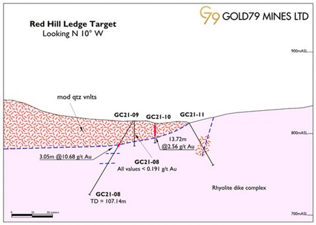
Figure 3. Generalized geologic section along the Red Hill Ledge presenting drill results
Roadside Mine Prospect
Five holes for a total of 281 meters were drilled on a roughly N-S line across the mineralized zone identified by historical drilling (Figure 2). All holes were drilled vertically to depths between 61.0 and 70.1 meters (Table 1).
This initial drilling has confirmed the presence of gold in Hole Nos. GC21-02 and -03 which contained 6.2m at 0.62 g/t gold and 21.3m at 0.98 g/t gold, respectively. This mineralized package is contained within a broader envelope of quartz veinlets for which additional sampling results are pending. Additionally, these results need to be considered relative to the surrounding historical intercepts and upon completion of this analysis, additional shallow drilling will likely be warranted to confirm the extent of mineralization.
Sunset Vein Prospect
Initial exploration along the 1km Sunset vein has identified a broad zone, up to 50 meters wide, of strong quartz-chalcedony veining developed along a silicified rhyolite dike emplaced into the Precambrian granite. Although surface sampling has only locally identified high gold values, i.e. >10 g/t Au, this broad zone of veining is widely anomalous in gold (>100 ppb Au) and consistent with a high vertical position in the epithermal system.
Hole No. GC21-06 was drilled from the footwall of the Sunset vein to a depth of 105.2m where the hole was lost in broken ground. The hole encountered moderate to strong veining to a depth of about 85m with broadly anomalous gold values (Table 1). The hole tested the vein complex to a depth of about 60m below the surface and did not emerge into the hanging wall of the dike where a surface working yielded a 11.47 g/t Au sample. Hole No. GC21-12 was collared further into the footwall (Figure 2) of the vein complex and was drilled to a depth of 130m. Like Hole No. GC21-06, this hole encountered moderate to strong quartz-chalcedony veining to a depth of 75 meters and was terminated in the rhyolite dike; gold values were also anomalous to similar depths. Additional drilling is warranted along the Sunset vein but at greater depths and from the hanging wall side of the vein-dike complex.
Next Steps for Gold Chain
Based on the significant results obtained in this initial drill program at Gold Chain the Company plans to prioritize follow-up programs as follows:
Qualified Person / Quality Control and Quality Assurance
Robert Johansing, M.Sc. Econ. Geol., P. Geo., the Company’s Vice President, Exploration is a qualified person as defined by NI 43-101 and has reviewed and approved the technical content of this press release. Mr. Johansing has also been responsible for all phases of drilling, sample collection, labelling, bagging and transport from the project to American Assay Laboratories of Sparks, Nevada. Samples were then dried, crushed and split, and pulp samples were prepared for analysis. Gold was determined by fire assay with an ICP finish, over limit samples were determined by fire assay and gravimetric finish. Silver plus 24 other elements were determined by Aqua Regia ICP-AES, over limit samples were determined by fire assay and gravimetric finish. Standard sample chain of custody procedures were employed during drilling until delivery to the analytical facility.
About Gold79 Mines Ltd.
Gold79 Mines Ltd. is a TSX Venture listed company focused on building ounces in the Southwest USA. Gold79 holds 100% earn-in option to purchase agreements on three gold projects: the Jefferson Canyon Gold Project and the Tip Top Gold Project both located in Nevada, USA, and, the Gold Chain Project located in Arizona, USA. In addition, Gold79 holds two projects with minority interest being a 36.6% interest in the Greyhound Project, Nunavut, Canada under JV by Agnico Eagle Mines Limited and a 20% carried interest in the Taviche Project in Oaxaca, Mexico now under option to Fortuna Silver Mines Inc.
Aldebaran Resources Inc. (TSX-V: ALDE) (OTCQX: ADBRF) is please... READ MORE
Erdene Resource Development Corp. (TSX:ERD) (MSE:ERDN) (OTCQX: ER... READ MORE
NOVAGOLD RESOURCES INC. (NYSE: NG) (TSX: NG) is pleased to report... READ MORE
~ Inferred Mineral Resources Increased by 630% to 20.3M AgEq Ounc... READ MORE
Copper Quest Exploration Inc. (CSE: CQX) (OTCQB: IMIMF) (FRA: 3MX... READ MORE


