First Nation Drill Company Engaged for Phase III Drilling at Case Lake
Power Metals Corp (TSX-V: PWM) (FRANKFURT: OAA1) (OTCQB: PWRMF) is pleased to confirm Black Diamond Drilling has been engaged to complete its 2024 Phase III drill program at the Company’s 100%-owned Case Lake Project in northeastern Ontario.
The objective of the 2024 Phase III program is to target and extend the known cesium zones at West Joe and Main Zone as part of the CLP, with 2,000 meters of exploration drilling to be completed.
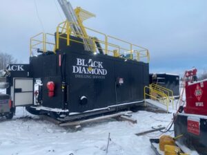
Black Diamond Drilling is a First Nation company 100%-owned by the community of Apitipi Anicinapek Nation in Ontario, Canada. The company is operated by a highly-experienced team with a focus on exploration projects in the Abitibi Greenstone Belt (see Figure 1).
Black Diamond is currently operating drill rigs at McEwen Mining and Alamos Gold in Ontario and has a partnership with Major Drilling Group International Inc. Black Diamond is independent from the Company.
Haydn Daxter, Power Metals CEO commented:
“Power Metals is extremely pleased to have engaged the team at Black Diamond Drilling, as part of Apitipi Anicinapek Nation, as we explore our world-class critical minerals project at Case Lake in Ontario.”
“Delivering local work to the local communities we operate in is a priority for our Company and we believe this is the beginning of a strong partnership with this First Nation company.”
“We look forward to fostering a strong partnership with AAN as we continue our engagement across many areas of the Power Metals business,” said CEO of Power Metals, Haydn Daxter.
Lance Black, President, Apitipi Resources Inc., parent company of Black Diamond Drilling Inc., and Director of Negotiations and Contract Management, Apitipi Anicinapek Nation commented:
“I am pleased to say that Power Metals has been engaging extremely well with the implementation of our exploration agreement. They consult with our team regularly and have site visits with our Lands and Resources Department about activity on our land and meet with our team in person to discuss the exploration activities.”
WATER SAMPLING
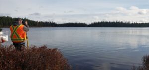
The Company recently completed its Phase II water sampling program at Case Lake with members of Apitipi Anicinapek Nation over a two-day period (see Figure 2). A total of eight points were sampled as part of the Case Lake waterway system, including lake and tributary locations.
This follows a recent training program on the collection and analysis of water samples conducted by the Company during Phase I sampling with members of Apitipi Anicinapek Nation and Blue Heron Environmental Consultants in Timmins.
Power Metals has developed this initiative in conjunction with traditional landowners to collaborate and share technical data on waterways of the Case Lake region.
SOIL SAMPLING
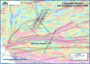
The Company recently completed a targeted soil sampling program to validate two cesium anomalies identified 500 meters to the north-northwest of the West Joe Prospect during a structural and geophysical assessment of the Case Lake Project. The two high-priority targets represented similar magnetic signatures and structural proximity to the current high-grade cesium mineralization at the West Joe Prospect.
The program was conducted over four days in mid-October with 177 samples (see Figure 3) collected by the geology team on loan from Winsome Resources (ASX: WR1) as part of our intercompany development.
The soil sampling program in the West Joe area was designed to validate two geophysical anomalies that show similarities to magnetic signature of LCT mineralization at West Joe (Table 1).
The samples were taken from five soil lines oriented at an oblique angle to geological strike of the regional fabric and glacial flow direction.
Samples were taken at every 25 meters along each line with 15% of the total samples being QAQC samples that were inserted into the sample stream.
Samples were submitted to Activation Laboratories Ltd in Timmins and were subsequently sent to Actlabs geochemical laboratory in Ancaster, Ontario for selective digestion-based multielement geochemical analysis.
| Table 1 – Summary of Soil Sample Locations as discussed in the announcement. | |||
| Sample # | Easting | Northing | Elevation (m) |
| 921XXX | 576156.8 | 5431898 | 333.61 |
| 921XXX | 576151.4 | 5431888 | 333.61 |
| 921XXX | 576146.1 | 5431878 | 334.4 |
| 921XXX | 576145.1 | 5431863 | 335.99 |
| 921XXX | 576138.4 | 5431855 | 335.99 |
| 921XXX | 576138.4 | 5431840 | 336.96 |
| 921XXX | 576130.9 | 5431829 | 337.15 |
| 921XXX | 576126.4 | 5431816 | 337.15 |
| 921XXX | 576120.7 | 5431801 | 337.16 |
| 921XXX | 576078.4 | 5431836 | 343.61 |
| 921XXX | 921646 | 5431843 | 343.61 |
| 921XXX | 576086.7 | 5431857 | 343.61 |
| 921XXX | 576092.8 | 5431870 | 343.8 |
| 921XXX | 576099.9 | 5431893 | 336.81 |
| 921XXX | 576108.6 | 5431917 | 336.43 |
| 921XXX | 576121 | 5431937 | 343.29 |
| 921XXX | 576123.6 | 5431963 | 342.65 |
| 921XXX | 576134.4 | 5431980 | 360.06 |
| 921XXX | 576142.4 | 5432009 | 360.77 |
| 921XXX | 576148.3 | 5432036 | 359.12 |
| 921XXX | 576157.9 | 5432058 | 358.58 |
| 921XXX | 576165 | 5432082 | 358.67 |
| 921XXX | 576174.8 | 5432105 | 358.46 |
| 921XXX | 576151.8 | 5432112 | 338 |
| 921XXX | 576142.1 | 5432090 | 356.58 |
| 921XXX | 576134.4 | 5432068 | 338 |
| 921XXX | 576126.8 | 5432041 | 356.16 |
| 921XXX | 576117.7 | 5432012 | 337.12 |
| 921XXX | 576109.7 | 5431996 | 356.83 |
| 921XXX | 576103.8 | 5431973 | 355.78 |
| 921XXX | 575969.1 | 5431514 | 340.64 |
| 921XXX | 575977.2 | 5431540 | 340.86 |
| 921XXX | 575986.9 | 5431565 | 341.19 |
| 921XXX | 575992.1 | 5431588 | 341.26 |
| 921XXX | 576003.8 | 5431608 | 340.77 |
| 921XXX | 576010.8 | 5431632 | 341.76 |
| 921XXX | 576018.6 | 5431657 | 341.76 |
| 921XXX | 576026.8 | 5431679 | 340.11 |
| 921XXX | 576036.1 | 5431704 | 340.16 |
| 921XXX | 576039.9 | 5431732 | 341.38 |
| 921XXX | 921919 | 5431752 | 340.27 |
| 921XXX | 576059.9 | 5431775 | 340.36 |
| 921XXX | 576063.1 | 5431791 | 340.52 |
| 921XXX | 576067.9 | 5431800 | 340.05 |
| 921XXX | 576070.3 | 5431809 | 339.42 |
| 921XXX | 576078.1 | 5431822 | 338.49 |
| 921XXX | 576114.9 | 5431781 | 337.39 |
| 921XXX | 576106.9 | 5431758 | 337.44 |
| 921XXX | 576098 | 5431737 | 339.22 |
| 921XXX | 576088.7 | 5431712 | 338.16 |
| 921XXX | 576081.6 | 5431690 | 338.34 |
| 921XXX | 576075.5 | 5431667 | 337.34 |
| 921XXX | 576066.3 | 5431643 | 336.68 |
| 921XXX | 576055.5 | 5431618 | 337.08 |
| 921XXX | 576051.6 | 5431593 | 337.44 |
| 921XXX | 576040.4 | 5431568 | 336.51 |
| 921XXX | 576035.4 | 5431546.5 | 334.09 |
| 921XXX | 576164.4 | 5431925 | 343.19 |
| 921XXX | 576172.6 | 5431946 | 342.72 |
| 921XXX | 576181.9 | 5431972 | 342.34 |
| 921XXX | 576186.4 | 5431994 | 341.9 |
| 921XXX | 576198.6 | 5432018 | 341.18 |
| 921XXX | 576203.9 | 5432041 | 341.85 |
| 921XXX | 576212.8 | 5432066 | 341.31 |
| 921XXX | 576221.3 | 5432091 | 341.47 |
| 921XXX | 576230.4 | 5432113 | 342.32 |
| 921XXX | 576238 | 5432137 | 343.26 |
| 921XXX | 576265.8 | 5432130 | 342.21 |
| 921XXX | 576250.6 | 5432105 | 341.48 |
| 921XXX | 576244.4 | 5432081 | 340.57 |
| 921XXX | 576237.3 | 5432056 | 341.05 |
| 921XXX | 576233.4 | 5432034 | 341.76 |
| 921XXX | 576219.8 | 5432012 | 341.9 |
| 921XXX | 576211.1 | 5431989 | 342.51 |
| 921XXX | 576206.8 | 5431960 | 342.01 |
| 921XXX | 576198.7 | 5431941 | 341.9 |
| 921XXX | 576184.5 | 5431917 | 341.92 |
| 921XXX | 576181.9 | 5431894 | 341.25 |
| 921XXX | 576096.8 | 5431946 | 346.28 |
| 921XXX | 576086.4 | 5431928 | 344.69 |
| 921XXX | 576078.3 | 5431908 | 344.83 |
| 921XXX | 576066.4 | 5431878.5 | 343.31 |
| 921XXX | 576065 | 5431866 | 344.09 |
| 921XXX | 576062.4 | 5431854 | 343.33 |
| 921XXX | 576054.9 | 5431843 | 336.82 |
| 921XXX | 576053.1 | 5431831 | 344.13 |
| 921XXX | 576052.1 | 5431818 | 345.84 |
| 921XXX | 576044.8 | 5431810 | 345.84 |
| 921XXX | 576040.1 | 5431794 | 336.64 |
| 921XXX | 576035.9 | 5431782 | 336.52 |
| 921XXX | 576028.7 | 5431759 | 335.45 |
| 921XXX | 921597 | 336.64 | 336.64 |
| 921XXX | 576012.9 | 5431714 | 333.5 |
| 921XXX | 575999.8 | 5431688 | 334.01 |
| 921XXX | 575995.1 | 5431665 | 334.79 |
| 921XXX | 575985 | 5431644 | 334.79 |
| 921XXX | 575977.7 | 5431615 | 333.16 |
| 921XXX | 575969.5 | 5431594 | 336.1 |
| 921XXX | 575959.2 | 5431575 | 330.27 |
| 921XXX | 575950.2 | 5431554 | 330.93 |
| 921XXX | 575947.8 | 5431518 | 335.54 |
| 921XXX | 576268.9 | 5431142 | 340.78 |
| 921XXX | 576176 | 5431882 | 340.32 |
| 921XXX | 576171.3 | 5431867 | 339.31 |
| 921XXX | 576168.3 | 5431857 | 339.2 |
| 921XXX | 576161.1 | 5431846 | 339.2 |
| 921XXX | 576160.6 | 5431834 | 338.53 |
| 921XXX | 576155.2 | 5431823 | 339.02 |
| 921XXX | 576150.9 | 5431810 | 338.96 |
| 921XXX | 576147.9 | 5431797 | 338.96 |
| 921XXX | 576140.1 | 5431773 | 340.47 |
| 921XXX | 576129.8 | 5431750 | 338.62 |
| 921XXX | 576122.3 | 5431727 | 337.49 |
| 921XXX | 576113.4 | 5431703.5 | 338.07 |
| 921XXX | 576106.06 | 5431678.5 | 338.06 |
| 921XXX | 576098.94 | 5431655 | 336.69 |
| 921XXX | 576091.4 | 5431633.5 | 336.64 |
| 921XXX | 576081.4 | 5431610 | 336.47 |
| 921XXX | 576073.44 | 5431583.5 | 335.32 |
| 921XXX | 576064.88 | 5431560.5 | 335.14 |
| 921XXX | 576085.63 | 5431537.5 | 333.58 |
| 921XXX | 576282.19 | 5431110 | 346.65 |
| 921XXX | 576431.75 | 5431488 | 338.39 |
| 921XXX | 576431.4 | 5431462.5 | 338.5 |
| 921XXX | 576423.9 | 5431443 | 339.9 |
| 921XXX | 576404.9 | 5431416 | 337.01 |
| 921XXX | 576385.4 | 5431388 | 334.56 |
| 921XXX | 576379.2 | 5431364 | 336.13 |
| 921XXX | 576381.4 | 5431349 | 337.03 |
| 921XXX | 576377.1 | 5431321 | 337.39 |
| 921XXX | 576369.7 | 5431295 | 337.57 |
| 921XXX | 576360 | 5431275 | 336.25 |
| 921XXX | 576355.8 | 5431255 | 336.77 |
| 921XXX | 576343.5 | 5431227.5 | 337.58 |
| 921XXX | 576340.94 | 5431205.5 | 338 |
| 921XXX | 576313.69 | 5431183.5 | 339.07 |
| 921XXX | 576318.5 | 5431158 | 345.81 |
| 921XXX | 576190.13 | 5430776.5 | 350.05 |
| 921XXX | 576194.75 | 5430802 | 345.73 |
| 921XXX | 576200.31 | 5430819 | 343.29 |
| 921XXX | 576214.13 | 5430846 | 344.65 |
| 921XXX | 576222.5 | 5430866 | 358.29 |
| 921XXX | 576226.69 | 5430901 | 361.5 |
| 921XXX | 576241.44 | 5430920 | 354.6 |
| 921XXX | 576250.19 | 5430951 | 363.28 |
| 921XXX | 576258.13 | 5430965 | 365.87 |
| 921XXX | 576260.19 | 5430990 | 355.67 |
| 921XXX | 576269.69 | 5431011 | 353.31 |
| 921XXX | 576279.38 | 5431039.5 | 349.3 |
| 921XXX | 576289.63 | 5431062 | 349.3 |
| 921XXX | 576303 | 5431074 | 348 |
Case Lake Property
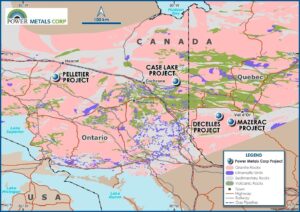
The Case Lake Property is located 80 km east of Cochrane, northeastern Ontario close to the Ontario – Quebec border. The Property consists of 585 cell claims in Steele, Case, Scapa, Pliny, Abbotsford and Challies townships, Larder Lake Mining Division. The Property is 10km by 9.5km in size with 14 granitic domes. The Case Lake pegmatite swarm consists of six spodumene dykes known as the North, Main, South, East and Northeast dykes on the Henry Dome, and the West Joe dyke on a new dome, collectively forming mineralization trend that extends for approximately 10km (Figure 4).
Power Metals have completed several exploration campaigns that have led to the discovery and expansion of new and historic spodumene bearing LCT pegmatites at Case Lake. The Company has drilled a total of 22,231 meters of core between 2017 and 2024 at the Property. The Case Lake Property is owned 100% by Power Metals Corp. A National Instrument 43-101 Technical Report has been prepared on Case Lake Property and filed on July 18, 2017 (Figure 4).
Pelletier Property
The Pelletier Property is located 50km south of Hearst, northeastern Ontario close to a network of forestry roads. The Property consists of 337 mineral claims that account for a total of 7000 hectares in Franz, Roche, Scholfield, and Talbot townships in the Porcupine mining division. The Pelletier Project is characterized by LCT prospective S-type pegmatitic granites intruding into metasedimentary and amphibolite of the Quetico at or near Archean terrane boundary between the Quetico and Wawa sub-provinces (Figure 4).
Decelles Property
The Decelles Property contains 669 claims, covering 38,404 hectares of LCT prospective ground near the mining centers of Val-dÓr and Rouyn-Noranda, approximately 600km from Montreal. Power Metals acquired the Decelles and Mazerac properties from Winsome Resources in 2023 in a deal that allowed Winsome to increase its stake to 19.59% (Refer to press release announced on August 24, 2023). The geology of Decelles property is part of the Archean Pontiac sub-province where S-type LCT prospective, pegmatite bearing, granitic Decelles Batholith intrudes into metasedimentary units of the Pontiac Group. Spodumene and Beryl bearing pegmatites have been reported historically within the Pontiac sub-province in association with S-type garnet-muscovite granite. The Decelles property is adjacent to Vision Lithium’s Cadillac property where discovery of high-grade lithium pegmatites was reported in 2022 (Figure 4).
Mazerac Property
The Mazerac Property is located approximately 30 km east of Power Metals’ Decelles property near well-established mining camps in the Abitibi region of Canada and is accessible by network of mining-grade forestry roads. The Mazerac property contains 259 claims that cover 14,700 hectares of LCT prospective ground near the mining center of Val-dÓr and Rouyn-Noranda. The regional geology of Mazerac is similar to Decelles where S-type LCT prospective, pegmatite bearing, granites of Decelles Batholith intrude into metasedimentary units of the Pontiac Group. Spodumene and Beryl bearing pegmatites have been reported historically within the Pontiac sub-province in association with S-type garnet-muscovite granite (Figure 4).
Pollucite and Cesium
Pollucite is a rare mineral that hosts high grade cesium and is associated with highly fractionated, rare element pegmatites. The main source of cesium known globally is pollucite (Cs,Na)₂(Al₂Si₄O₁₂)•2H₂O, (https://www.gov.mb.ca/iem/geo/industrial/pollucite.html). Currently the Tanco mine in Manitoba, Canada is the only operating cesium deposit and holds over 60% of the known reserves globally.
Scientific and Technical Disclosure
The scientific and technical disclosure included in this news release has been reviewed and approved by Amanuel Bein, P.Geo., Vice President of Exploration for Power Metals, a Qualified Person under National Instrument 43-101 Standards of Disclosure of Mineral Projects.
Power Metals
Power Metals Corp. is a diversified Canadian mining company with a mandate to explore, develop and acquire high quality mining projects. We are committed to building an arsenal of projects in both lithium and high-growth specialty metals and minerals. We see an unprecedented opportunity to supply the tremendous growth of the lithium battery and clean-technology industries. Learn more at www.powermetalscorp.com.

Figure 1 – Image of a Black Diamond drill rig, in operation, in northeastern Ontario, Canada (CNW Group/Power Metals Corp.)

Figure 2 – Power Metals and Apitipi Anicinapek Nation team conduct water sampling at Case Lake (CNW Group/Power Metals Corp.)

Figure 3 – Map of soil sampling locations conducted NNW of West Joe, along with test line through the West Joe Prospect (CNW Group/Power Metals Corp.)

Figure 4 – Power Metals Corp Project Locations Map in Ontario and Quebec Canada (CNW Group/Power Metals Corp.)
MORE or "UNCATEGORIZED"
Delta Reports New Gold Intercept at Nova Target in Wedge Area, 4 Kilometres West of Eureka; Follow-Up Drill Program Underway
Delta Reports New Gold Intercept at Nova Target in Wedge Area, 4 ... READ MORE
Silver One Announces Closing Of Final Tranche Of $32 Million Financing
Silver One Resources Inc. (TSX-V: SVE) (OTCQX: SLVRF) (FSE: BRK1)... READ MORE
SAGA Metals Achieves 100% Drilling Success in 2025—Reports Final Assays from Trapper South at Radar Critical Minerals Project in Labrador
Exceptional grades of Titanium, Vanadium and Iron in all 15 drill... READ MORE
Near Surface Intersection Yields 6.58 g/t gold over 10.35 metres
Intersection is within 33 metres from surface and contained in a ... READ MORE
Alamos Gold Provides Three-Year Operating Guidance Outlining 46% Production Growth by 2028 at Significantly Lower Costs
Further production growth to one million ounces annually expected... READ MORE


