


Eloro Resources Ltd. (TSX-V: ELO) (OTCQX: ELRRF) (FSE: P2QM) is pleased to announce assay results from an additional six (6) diamond drill holes from its on-going drilling program at the Iska Iska silver-tin polymetallic project in the Potosi Department, southern Bolivia. Holes DSBU-05 and DSBU-06 are underground holes drilled from the Santa Barbara adit to test the northern extension of the higher-grade mineralized zone. Hole DSBS-01 was collared in the southern part of the Santa Barbara target zone and drilled at an azimuth of 300 and dip of -300 to test the same target. Holes DSB-24, DSB-14 and DSB-22 were drilled at azimuths of 2250 to test the northwest extension of the Santa Barbara mineralized zone approximately 100m, 200m, and 1,000m, respectively, northwest of the Santa Barbara adit underground drill bay. Drilling is continuing in the Porco area to test for a potential Sn porphyry as suggested by the 3D inverse magnetic model (see Eloro press release March 1, 2022). Thus far, 4,870 m in five (5) holes have been completed in the Porco target area with assays pending.
Overall, the Company has completed 52,384m in 89 drill holes to-date, including four holes in progress, as shown in Figures 1 and 2. Currently there are three (3) surface drills and one (1) underground drill operating at Iska Iska. Tables 1, 2 and 3 list significant assay results for the drill holes in the major target areas. Prices used for calculating Ag equivalent grades are as outlined in Eloro’s February 1, 2022, press release. Table 4 summarizes drill holes with assays pending. Highlights are as follows:
Santa Barbara Mineral Resource Definition Target Area – Underground Drilling
Underground holes DSBU-06 and DSBU-05 were both drilled on azimuth 00 and dips of -650 and -400, respectively, from the Santa Barbara adit to test the northern extent of higher-grade mineralization in the eastern part of the Santa Barbara target area.
Dr. Bill Pearson, P.Geo. Executive Vice President, Exploration commented: “As shown in Figure 3, a N-S cross section looking east, holes DSBU-06 and DSBU-05 define a significant extension to the north of the major high grade mineralized area in the southern part of Santa Barbara. Further drilling, especially deeper, is in progress to define the full extent of this important high-grade zone. Analysis of borehole IP data and the 3D inverse magnetic model by Eloro’s geophysicists Dr. Chris Hale, P.Geo. and John Gilliatt, P.Geo. shows that the Mx Chargeability indicates stronger mineralization at greater depth as shown in Figure 4. The spatial agreement between the interpolated chargeability and the mineralization intersected in these holes also suggests that the mineralized zone may dip steeply to the south. Further deeper drilling will be carried out to test this highly prospective target. Drilling will also be carried out from the southwest to test the Northwest Extension target as the best mineralization intersected thus far is in the southern part of this target zone.”
Dr. Pearson continued, “The addition of a fourth drill and the more rapid turnaround from both our assay laboratories at ALS and AHK has allowed us to increase the pace of the exploration drill program considerably. In the next 2-3 weeks we expect to have the GeologicAI core scanner on site. We have worked closely with GeologicAI to build the database for the scanner from all our available geological and geochemical information. The scanner will allow us to better outline and track the mineral and metal zonation at Iska Iska, which is critical to efficiently explore this remarkable mineralizing system which remains open in all directions.”
Dr. Osvaldo Arce, P.Geo., General Manager of Eloro’s Bolivian subsidiary Minera Tupiza S.R.L. further commented: “The dacitic volcanic domes and breccia pipes at Iska Iska, which are the primary hosts of the epithermal polymetallic Ag-Zn-Pb-Sn mineralization, appear to extend to a depth of at least 1km. These intrude altered granodiorite and intrusion breccias that are the primary hosts of xenothermal tin and other higher temperature metals such as bismuth and tungsten. The mineralization is quite complex in detail with extensive breccias, veins, veinlets, stockworks and disseminations. The likely primary distribution of both epithermal and xenothermal mineralization is indicated by the metal zonation, alteration zonation and geophysical responses. This data indicates that the mineralized system strengthens with depth and may be much more extensive than indicated in shallower drill holes.”
Santa Barbara Mineral Resource Definition Target Area – Surface Drilling
Hole DSBS-01 was collared in the southern part of the Santa Barbara target zone as shown in Figure 2. This hole was drilled at an azimuth of 300 with a dip of 300 to a length of 700.8m.
Further drilling is planned south-southeast of this area to continue to trace the full extent of the Ag-Au-Zn-Pb-Cu-Sn polymetallic epithermal system.
Northwest Extension, Santa Barbara Mineral Resource Definition Target Area
Results for three (3) additional drillholes all drilled at an azimuth of 2250 in the Northwest Extension Target Area of Santa Barbara (see Figure 2) have been received. Holes DSB-24 (-650), DSB-14 (-650) and DSB-22 (650) were collared 100m, 200m and 1000m, respectively northwest of the Santa Barbara adit drill bay.
Hole DSB-24 intersected 22 reportable intersections as shown in Table 2 of which the best results were deeper in the hole as follows:
Hole DHK-14, which was collared 100m northwest of Hole DSB-24, intersected 29 reportable intersections of which the best results were as follows:
Hole DHK-22 is the most northwesterly drill hole completed thus far, approximately 1,000m (1km) northwest of the Santa Barbara Drill Bay (see Figure 2). There were 10 reportable intersections returned from this hole with the best results as follows:
Table 1: Significant Results, Underground Diamond Drilling, Santa Barbara Resource Definition Target Area as at April 27, 2022.
| SANTA BARBARA RESOURCE DEFINITION TARGET ZONE | ||||||||||||
| UNDERGROUND DRILL HOLES – SANTA BARBARA ADIT | ||||||||||||
| Hole No. | From (m) | To (m) | Length (m) | Ag | Au | Zn | Pb | Cu | Sn | Bi | Cd | Ag eq |
| g/t | g/t | % | % | % | % | % | % | g/t | ||||
| DSBU-06 | 0.00 | 235.55 | 235.55 | 64.30 | 0.09 | 0.69 | 0.37 | 0.06 | 0.07 | 0.016 | 0.007 | 169.11 |
| Incl. | 24.40 | 75.08 | 50.68 | 192.18 | 0.22 | 0.07 | 0.41 | 0.09 | 0.11 | 0.059 | 0.005 | 314.52 |
| 264.14 | 392.58 | 128.44 | 17.38 | 0.09 | 0.30 | 0.21 | 0.01 | 0.11 | 0.002 | 0.001 | 110.57 | |
| Incl. | 274.69 | 292.86 | 18.17 | 11.62 | 0.01 | 0.45 | 0.32 | 0.01 | 0.25 | 0.001 | 0.002 | 190.81 |
| Incl. | 319.04 | 331.03 | 11.99 | 14.87 | 0.01 | 0.28 | 0.25 | 0.02 | 0.26 | 0.001 | 0.001 | 193.82 |
| 401.61 | 415.13 | 13.52 | 47.18 | 0.09 | 0.58 | 0.09 | 0.01 | 0.03 | 0.003 | 0.002 | 101.67 | |
| 421.19 | 434.67 | 13.48 | 12.23 | 0.01 | 0.40 | 0.11 | 0.01 | 0.02 | 0.002 | 0.002 | 50.62 | |
| 445.18 | 482.80 | 37.62 | 19.38 | 0.04 | 0.84 | 0.16 | 0.01 | 0.06 | 0.002 | 0.002 | 104.11 | |
| 497.86 | 520.48 | 22.62 | 22.32 | 0.04 | 0.51 | 0.11 | 0.01 | 0.03 | 0.013 | 0.001 | 71.31 | |
| 528.92 | 592.30 | 63.38 | 9.91 | 0.21 | 0.54 | 0.14 | 0.01 | 0.04 | 0.002 | 0.002 | 80.81 | |
| DSBU-05 | 0.00 | 153.25 | 153.25 | 22.99 | 0.07 | 0.18 | 0.16 | 0.21 | 0.12 | 0.010 | 0.003 | 141.05 |
| Incl. | 0.00 | 34.97 | 34.97 | 21.77 | 0.06 | 0.36 | 0.30 | 0.63 | 0.11 | 0.007 | 0.003 | 201.23 |
| Incl. | 76.94 | 85.99 | 9.05 | 24.52 | 0.18 | 0.14 | 0.16 | 0.11 | 0.23 | 0.013 | 0.004 | 206.03 |
| Incl. | 109.93 | 135.53 | 25.60 | 31.67 | 0.04 | 0.23 | 0.19 | 0.17 | 0.28 | 0.014 | 0.001 | 242.83 |
| 190.40 | 212.94 | 22.54 | 6.06 | 0.04 | 0.42 | 0.41 | 0.02 | 0.04 | 0.013 | 0.012 | 73.74 | |
| 229.48 | 235.54 | 6.06 | 6.19 | 0.02 | 0.43 | 0.10 | 0.05 | 0.05 | 0.004 | 0.003 | 67.75 | |
| 249.08 | 261.10 | 12.02 | 18.11 | 0.27 | 0.07 | 0.23 | 0.02 | 0.01 | 0.005 | 0.011 | 62.92 | |
| 285.03 | 306.00 | 20.97 | 57.04 | 0.06 | 0.06 | 0.14 | 0.04 | 0.03 | 0.008 | 0.007 | 94.58 | |
| 249.08 | 261.10 | 12.02 | 18.11 | 0.27 | 0.07 | 0.23 | 0.02 | 0.01 | 0.005 | 0.011 | 62.92 | |
| 348.08 | 526.17 | 178.09 | 23.86 | 0.03 | 0.96 | 0.21 | 0.01 | 0.02 | 0.013 | 0.004 | 92.47 | |
| 535.29 | 541.40 | 6.11 | 6.68 | 0.09 | 0.84 | 0.12 | 0.00 | 0.05 | 0.004 | 0.002 | 85.49 | |
| 551.91 | 553.44 | 1.53 | 26.00 | 0.09 | 2.56 | 0.08 | 0.01 | 0.05 | 0.038 | 0.007 | 189.67 | |
| 583.55 | 585.04 | 1.49 | 2.00 | 0.03 | 1.44 | 0.01 | 0.01 | 0.02 | 0.001 | 0.004 | 84.03 | |
| 605.90 | 610.32 | 4.42 | 4.61 | 0.05 | 2.00 | 0.04 | 0.01 | 0.01 | 0.001 | 0.007 | 111.87 | |
Note: True width of the mineralization is not known at the present time, but based on the current understanding of the relationship between drill orientation/inclination and the mineralization within the breccia pipes and the host rocks such as sandstones and dacites, it is estimated that true width ranges between 70% and 90% of the down hole interval length but this will be confirmed by further drilling and geological modelling.
Chemical symbols: Ag= silver, Au = gold, Zn = zinc, Pb = lead, Cu = copper, Sn = tin, Bi = bismuth, Cd = cadmium and g Ag eq/t = grams silver equivalent per tonne. Quantities are given in percent (%) for Zn, Pb Cu, Sn, Bi and Cd and in grams per tonne (g/t) for Ag, Au and Ag eq.
Metal prices and conversion factors used for calculation of g Ag eq/t (grams Ag per grams x metal ratio) are as follows (Prices updated as of February 1, 2022, to more accurately reflect current metal prices):
| Element | Price $US (per kg) | Ratio to Ag |
| Ag | $722.56 | 1.0000 |
| Sn | $42.56 | 0.0589 |
| Zn | $3.30 | 0.0046 |
| Pb | $2.33 | 0.0032 |
| Au | $57,604.00 | 79.7221 |
| Cu | $9.68 | 0.0134 |
| Bi | $12.76 | 0.0177 |
| Cd | $5.50 | 0.0076 |
In calculating the intersections reported in this press release a sample cutoff of 30 g Ag eq/t was used with generally a maximum dilution of 3 continuous samples below cutoff included within a mineralized section unless more dilution is justified geologically.
The equivalent grade calculations are based on the stated metal prices and are provided for comparative purposes only, due to the polymetallic nature of the deposit. Metallurgical tests are in progress by Blue Coast Ltd. to establish levels of recovery for each element reported but currently the potential recovery for each element has not yet been established. While there is no assurance that all or any of the reported concentrations of metals will be recoverable, Bolivia has a long history of successfully mining and processing similar polymetallic deposits which is well documented in the landmark volume “Yacimientos Metaliferos de Bolivia” by Dr. Osvaldo R. Arce Burgoa, P.Geo.
Table 2: Significant Results, Surface Diamond Drilling, Santa Barbara Resource Definition Target Area as at April 27, 2022.
| SANTA BARBARA RESOURCE DEFINITION TARGET ZONE | ||||||||||||
| SURFACE DIAMOND DRILLING – SOUTH SANTA BARBARA AREA | ||||||||||||
| Hole No. | From (m) | To (m) | Length (m) | Ag | Au | Zn | Pb | Cu | Sn | Bi | Cd | Ag eq |
| g/t | g/t | % | % | % | % | % | % | g/t | ||||
| DSBS-01 | 13.42 | 30.29 | 16.87 | 0.91 | 0.01 | 0.00 | 0.01 | 0.00 | 0.09 | 0.001 | 0.001 | 52.59 |
| 58.66 | 90.94 | 32.28 | 2.07 | 0.01 | 0.00 | 0.03 | 0.00 | 0.27 | 0.001 | 0.001 | 163.23 | |
| Incl. | 63.15 | 70.76 | 7.61 | 3.73 | 0.02 | 0.00 | 0.04 | 0.01 | 0.94 | 0.001 | 0.001 | 560.74 |
| 98.94 | 100.45 | 1.51 | 4.00 | 0.01 | 0.00 | 0.03 | 0.01 | 0.09 | 0.001 | 0.001 | 61.61 | |
| 225.36 | 247.94 | 22.58 | 2.94 | 0.01 | 0.03 | 0.14 | 0.30 | 0.01 | 0.001 | 0.001 | 54.95 | |
| Incl. | 225.36 | 228.40 | 3.04 | 3.00 | 0.01 | 0.07 | 0.07 | 0.88 | 0.00 | 0.001 | 0.001 | 129.69 |
| 270.52 | 271.95 | 1.43 | 5.00 | 0.02 | 0.04 | 1.41 | 0.02 | 0.02 | 0.001 | 0.001 | 64.90 | |
| 285.56 | 329.16 | 43.60 | 5.36 | 0.03 | 0.85 | 0.44 | 0.02 | 0.05 | 0.002 | 0.010 | 90.79 | |
| Incl. | 294.43 | 299.02 | 4.59 | 2.01 | 0.07 | 1.36 | 0.49 | 0.05 | 0.09 | 0.004 | 0.012 | 146.04 |
| Incl. | 320.19 | 329.16 | 8.97 | 12.68 | 0.03 | 1.95 | 0.93 | 0.01 | 0.11 | 0.001 | 0.012 | 200.55 |
| 344.23 | 345.57 | 1.34 | 1.00 | 0.01 | 1.10 | 0.26 | 0.00 | 0.01 | 0.001 | 0.006 | 67.32 | |
| 357.63 | 359.19 | 1.56 | 3.00 | 0.01 | 1.31 | 0.27 | 0.00 | 0.01 | 0.001 | 0.002 | 75.16 | |
| 374.14 | 375.69 | 1.55 | 2.00 | 0.02 | 1.35 | 0.28 | 0.01 | 0.00 | 0.001 | 0.004 | 76.69 | |
| 414.88 | 470.51 | 55.63 | 6.66 | 0.03 | 1.80 | 0.40 | 0.03 | 0.00 | 0.003 | 0.005 | 110.40 | |
| Incl. | 416.39 | 420.84 | 4.45 | 28.05 | 0.19 | 4.99 | 1.26 | 0.22 | 0.01 | 0.032 | 0.019 | 351.80 |
| Incl. | 437.41 | 446.45 | 9.04 | 4.34 | 0.01 | 2.95 | 0.32 | 0.01 | 0.00 | 0.001 | 0.008 | 153.44 |
| 484.02 | 485.54 | 1.52 | 3.00 | 0.01 | 1.27 | 0.14 | 0.01 | 0.00 | 0.001 | 0.003 | 68.15 | |
| 491.56 | 523.27 | 31.71 | 12.96 | 0.11 | 1.43 | 0.43 | 0.02 | 0.01 | 0.004 | 0.005 | 108.55 | |
| Incl. | 509.62 | 520.25 | 10.63 | 27.91 | 0.25 | 2.29 | 0.89 | 0.03 | 0.01 | 0.008 | 0.009 | 192.64 |
| 541.79 | 549.58 | 7.79 | 2.69 | 0.01 | 1.38 | 0.10 | 0.00 | 0.00 | 0.001 | 0.005 | 72.22 | |
| 591.69 | 594.70 | 3.01 | 3.51 | 0.02 | 1.24 | 0.13 | 0.01 | 0.00 | 0.001 | 0.003 | 68.82 | |
| 599.26 | 600.79 | 1.53 | 13.00 | 0.13 | 4.03 | 0.32 | 0.01 | 0.01 | 0.003 | 0.018 | 224.85 | |
| 611.34 | 636.83 | 25.49 | 8.94 | 0.03 | 1.02 | 0.20 | 0.01 | 0.00 | 0.001 | 0.003 | 68.66 | |
| Incl. | 627.90 | 636.83 | 8.93 | 19.98 | 0.04 | 1.65 | 0.35 | 0.01 | 0.00 | 0.003 | 0.006 | 114.99 |
| 668.88 | 670.41 | 1.53 | 111.00 | 0.01 | 0.27 | 3.64 | 0.00 | 0.00 | 0.001 | 0.001 | 242.99 | |
| 683.93 | 689.86 | 5.93 | 9.73 | 0.11 | 2.69 | 0.35 | 0.02 | 0.00 | 0.003 | 0.013 | 157.74 | |
See Note Table 1.
Table 3: Significant Results, Surface Diamond Drilling, Santa Barbara Resource Definition Target Area – Northwest Extension as at April 27, 2022.
| SANTA BARBARA RESOURCE DEFINITION TARGET ZONE | ||||||||||||
| SURFACE DIAMOND DRILLING – NORTHWEST EXTENSION | ||||||||||||
| Hole No. | From (m) | To (m) | Length (m) | Ag | Au | Zn | Pb | Cu | Sn | Bi | Cd | Ag eq |
| g/t | g/t | % | % | % | % | % | % | g/t | ||||
| DSB-14 | 60.17 | 61.69 | 1.52 | 9.00 | 2.08 | 0.00 | 0.03 | 0.04 | 0.00 | 0.001 | 0.001 | 182.35 |
| 82.80 | 84.44 | 1.64 | 27.00 | 0.39 | 0.00 | 0.02 | 0.04 | 0.00 | 0.001 | 0.001 | 65.49 | |
| 97.86 | 100.83 | 2.97 | 68.63 | 0.01 | 0.00 | 0.13 | 0.16 | 0.00 | 0.001 | 0.001 | 97.15 | |
| 120.36 | 157.93 | 37.57 | 17.15 | 0.06 | 0.01 | 0.51 | 0.28 | 0.02 | 0.004 | 0.001 | 87.26 | |
| 180.45 | 196.91 | 16.46 | 7.95 | 0.04 | 0.01 | 0.19 | 0.26 | 0.01 | 0.001 | 0.001 | 58.44 | |
| 202.91 | 213.55 | 10.64 | 8.75 | 0.01 | 0.01 | 0.21 | 0.15 | 0.04 | 0.001 | 0.001 | 62.48 | |
| 231.57 | 236.38 | 4.81 | 2.01 | 0.01 | 0.04 | 0.17 | 0.29 | 0.01 | 0.001 | 0.005 | 54.82 | |
| 267.76 | 293.36 | 25.60 | 1.57 | 0.01 | 0.71 | 0.19 | 0.01 | 0.02 | 0.001 | 0.003 | 54.95 | |
| 314.33 | 347.44 | 33.11 | 5.26 | 0.01 | 0.31 | 0.21 | 0.01 | 0.05 | 0.001 | 0.004 | 58.63 | |
| Incl. | 314.33 | 324.87 | 10.54 | 7.83 | 0.02 | 0.57 | 0.25 | 0.01 | 0.09 | 0.001 | 0.003 | 96.83 |
| 367.01 | 368.54 | 1.53 | 8.00 | 0.01 | 0.26 | 0.58 | 0.01 | 0.09 | 0.004 | 0.005 | 91.01 | |
| 382.18 | 389.59 | 7.41 | 23.89 | 0.01 | 0.32 | 0.12 | 0.01 | 0.07 | 0.003 | 0.001 | 87.18 | |
| 398.65 | 410.68 | 12.03 | 26.58 | 0.06 | 0.14 | 0.05 | 0.01 | 0.04 | 0.003 | 0.001 | 65.02 | |
| 430.28 | 431.78 | 1.50 | 6.00 | 0.60 | 0.15 | 0.19 | 0.02 | 0.03 | 0.008 | 0.001 | 85.91 | |
| 448.25 | 454.20 | 5.95 | 3.98 | 0.03 | 0.68 | 0.20 | 0.02 | 0.02 | 0.001 | 0.002 | 58.96 | |
| 464.72 | 467.78 | 3.06 | 18.83 | 0.01 | 1.24 | 0.99 | 0.02 | 0.04 | 0.001 | 0.006 | 137.60 | |
| 475.27 | 478.20 | 2.93 | 5.47 | 0.01 | 0.58 | 1.12 | 0.00 | 0.01 | 0.001 | 0.041 | 76.07 | |
| 481.22 | 482.72 | 1.50 | 9.00 | 0.02 | 0.01 | 0.19 | 0.00 | 0.02 | 0.001 | 0.010 | 77.26 | |
| 518.20 | 521.07 | 2.87 | 29.09 | 0.10 | 0.40 | 1.19 | 0.01 | 0.45 | 0.003 | 0.008 | 360.91 | |
| 528.61 | 530.10 | 1.49 | 8.00 | 0.03 | 0.16 | 0.25 | 0.02 | 0.10 | 0.001 | 0.011 | 89.86 | |
| 549.27 | 555.12 | 5.85 | 6.62 | 0.01 | 0.27 | 0.21 | 0.02 | 0.06 | 0.001 | 0.001 | 67.81 | |
| 567.11 | 570.11 | 3.00 | 7.82 | 0.02 | 0.64 | 0.16 | 0.02 | 0.07 | 0.001 | 0.003 | 86.20 | |
| 597.64 | 614.50 | 16.86 | 10.38 | 0.09 | 1.43 | 0.20 | 0.09 | 0.14 | 0.007 | 0.005 | 185.94 | |
| 632.50 | 633.92 | 1.42 | 7.00 | 0.05 | 1.27 | 0.08 | 0.07 | 0.06 | 0.002 | 0.001 | 118.00 | |
| 650.26 | 654.83 | 4.57 | 4.90 | 0.05 | 1.41 | 0.09 | 0.11 | 0.03 | 0.002 | 0.001 | 112.37 | |
| 841.10 | 842.60 | 1.50 | 4.00 | 0.02 | 0.18 | 0.04 | 0.45 | 0.02 | 0.002 | 0.001 | 85.19 | |
| 884.56 | 886.05 | 1.49 | 1.00 | 0.05 | 0.49 | 0.03 | 0.14 | 0.02 | 0.023 | 0.002 | 64.76 | |
| 889.06 | 890.56 | 1.50 | 4.00 | 0.02 | 0.76 | 0.14 | 0.15 | 0.03 | 0.007 | 0.002 | 81.53 | |
| 893.59 | 895.06 | 1.47 | 5.00 | 0.02 | 0.73 | 0.19 | 0.23 | 0.02 | 0.005 | 0.003 | 89.45 | |
| 955.14 | 959.62 | 4.48 | 2.33 | 0.06 | 0.09 | 0.02 | 0.17 | 0.00 | 0.153 | 0.001 | 63.84 | |
| SANTA BARBARA RESOURCE DEFINITION TARGET ZONE | ||||||||||||
| SURFACE DIAMOND DRILLING – NORTHWEST EXTENSION | ||||||||||||
| Hole No. | From (m) | To (m) | Length (m) | Ag | Au | Zn | Pb | Cu | Sn | Bi | Cd | Ag eq |
| g/t | g/t | % | % | % | % | % | % | g/t | ||||
| DSB-24 | 0.00 | 8.79 | 8.79 | 4.48 | 0.21 | 0.01 | 0.12 | 0.01 | 0.06 | 0.005 | 0.001 | 60.86 |
| 75.19 | 106.48 | 31.29 | 14.70 | 0.03 | 0.02 | 0.15 | 0.10 | 0.01 | 0.001 | 0.001 | 44.47 | |
| 137.98 | 142.43 | 4.45 | 0.83 | 0.45 | 0.20 | 0.16 | 0.01 | 0.01 | 0.001 | 0.016 | 61.21 | |
| 162.03 | 163.57 | 1.54 | 3.00 | 0.02 | 0.94 | 0.41 | 0.08 | 0.09 | 0.002 | 0.026 | 126.97 | |
| 171.08 | 198.08 | 27.00 | 6.75 | 0.03 | 0.34 | 0.23 | 0.03 | 0.03 | 0.001 | 0.032 | 56.40 | |
| 213.00 | 225.06 | 12.06 | 17.98 | 0.09 | 0.64 | 0.37 | 0.04 | 0.02 | 0.005 | 0.002 | 86.19 | |
| 231.20 | 232.61 | 1.41 | 10.00 | 0.04 | 0.16 | 0.08 | 0.06 | 0.05 | 0.002 | 0.001 | 61.51 | |
| 240.13 | 244.64 | 4.51 | 7.00 | 0.13 | 0.40 | 0.17 | 0.03 | 0.03 | 0.006 | 0.004 | 63.72 | |
| 255.14 | 258.14 | 3.00 | 15.45 | 0.12 | 0.40 | 0.14 | 0.01 | 0.02 | 0.014 | 0.003 | 62.14 | |
| 262.59 | 264.08 | 1.49 | 24.00 | 0.01 | 0.18 | 0.11 | 0.00 | 0.03 | 0.056 | 0.001 | 62.66 | |
| 280.53 | 295.46 | 14.93 | 9.51 | 0.03 | 0.48 | 0.08 | 0.02 | 0.02 | 0.009 | 0.002 | 49.93 | |
| 340.05 | 344.53 | 4.48 | 8.76 | 0.01 | 0.48 | 0.43 | 0.01 | 0.02 | 0.004 | 0.015 | 59.13 | |
| 371.50 | 386.58 | 33.23 | 41.22 | 0.03 | 0.34 | 0.23 | 0.01 | 0.09 | 0.001 | 0.002 | 120.18 | |
| Incl. | 353.35 | 368.52 | 15.17 | 34.92 | 0.02 | 0.48 | 0.31 | 0.01 | 0.10 | 0.001 | 0.003 | 130.97 |
| 398.61 | 423.97 | 25.36 | 16.72 | 0.02 | 0.30 | 0.10 | 0.01 | 0.16 | 0.001 | 0.001 | 132.43 | |
| 450.91 | 461.50 | 10.59 | 22.91 | 0.02 | 0.03 | 0.01 | 0.02 | 0.04 | 0.001 | 0.001 | 52.03 | |
| 483.64 | 507.27 | 23.63 | 5.25 | 0.03 | 0.73 | 0.08 | 0.00 | 0.26 | 0.001 | 0.005 | 197.26 | |
| 529.03 | 533.64 | 4.61 | 8.01 | 0.07 | 0.11 | 0.06 | 0.00 | 0.09 | 0.001 | 0.001 | 74.66 | |
| 562.00 | 563.50 | 1.50 | 9.00 | 0.07 | 0.43 | 0.22 | 0.02 | 0.07 | 0.001 | 0.001 | 84.64 | |
| 593.43 | 594.96 | 1.53 | 9.00 | 0.02 | 0.09 | 0.02 | 0.08 | 0.08 | 0.001 | 0.001 | 71.81 | |
| 656.43 | 663.91 | 7.48 | 2.22 | 0.26 | 0.59 | 0.09 | 0.01 | 0.03 | 0.002 | 0.002 | 73.60 | |
| 680.29 | 684.93 | 4.64 | 4.95 | 0.11 | 0.30 | 0.03 | 0.04 | 0.03 | 0.009 | 0.001 | 51.68 | |
| 701.50 | 702.97 | 1.47 | 3.00 | 0.04 | 0.41 | 0.01 | 0.06 | 0.05 | 0.001 | 0.001 | 64.81 | |
| Hole No. | From (m) | To (m) | Length (m) | Ag | Au | Zn | Pb | Cu | Sn | Bi | Cd | Ag eq |
| g/t | g/t | % | % | % | % | % | % | g/t | ||||
| DSB-22 | 38.77 | 67.50 | 28.73 | 2.99 | 0.01 | 0.00 | 0.08 | 0.42 | 0.01 | 0.001 | 0.001 | 70.09 |
| Incl. | 52.33 | 64.48 | 12.15 | 2.75 | 0.01 | 0.00 | 0.08 | 0.75 | 0.01 | 0.001 | 0.001 | 110.81 |
| 117.90 | 119.41 | 1.51 | 2.00 | 0.99 | 0.02 | 0.06 | 0.01 | 0.01 | 0.018 | 0.013 | 92.81 | |
| 140.44 | 142.06 | 1.62 | 3.00 | 0.10 | 0.79 | 0.11 | 0.01 | 0.01 | 0.001 | 0.072 | 63.27 | |
| 209.50 | 211.02 | 1.52 | 2.00 | 0.01 | 0.10 | 0.00 | 0.01 | 0.12 | 0.001 | 0.001 | 78.13 | |
| 268.23 | 269.69 | 1.46 | 42.00 | 0.04 | 0.03 | 0.16 | 0.03 | 0.09 | 0.001 | 0.001 | 108.86 | |
| 280.22 | 281.75 | 1.53 | 133.00 | 0.13 | 0.31 | 0.03 | 0.02 | 0.02 | 0.050 | 0.001 | 180.55 | |
| 280.22 | 296.71 | 8.93 | 5.47 | 0.02 | 1.16 | 0.07 | 0.01 | 0.01 | 0.001 | 0.001 | 70.72 | |
| 455.21 | 456.73 | 1.52 | 25.00 | 2.02 | 0.40 | 0.01 | 0.09 | 0.07 | 0.069 | 0.001 | 267.16 | |
| 479.32 | 525.70 | 46.38 | 11.81 | 0.12 | 0.23 | 0.00 | 0.13 | 0.10 | 0.012 | 0.001 | 107.19 | |
| Incl. | 479.32 | 486.82 | 7.50 | 39.32 | 0.09 | 0.18 | 0.01 | 0.50 | 0.46 | 0.030 | 0.001 | 398.55 |
| 593.08 | 609.64 | 16.56 | 7.42 | 0.18 | 0.76 | 0.03 | 0.13 | 0.02 | 0.002 | 0.001 | 84.87 | |
See Note Table 1.
Figure 1 – Geological Plan Map showing Major Drilling areas. Santa Barbara is shown in more detail in Figure 2.
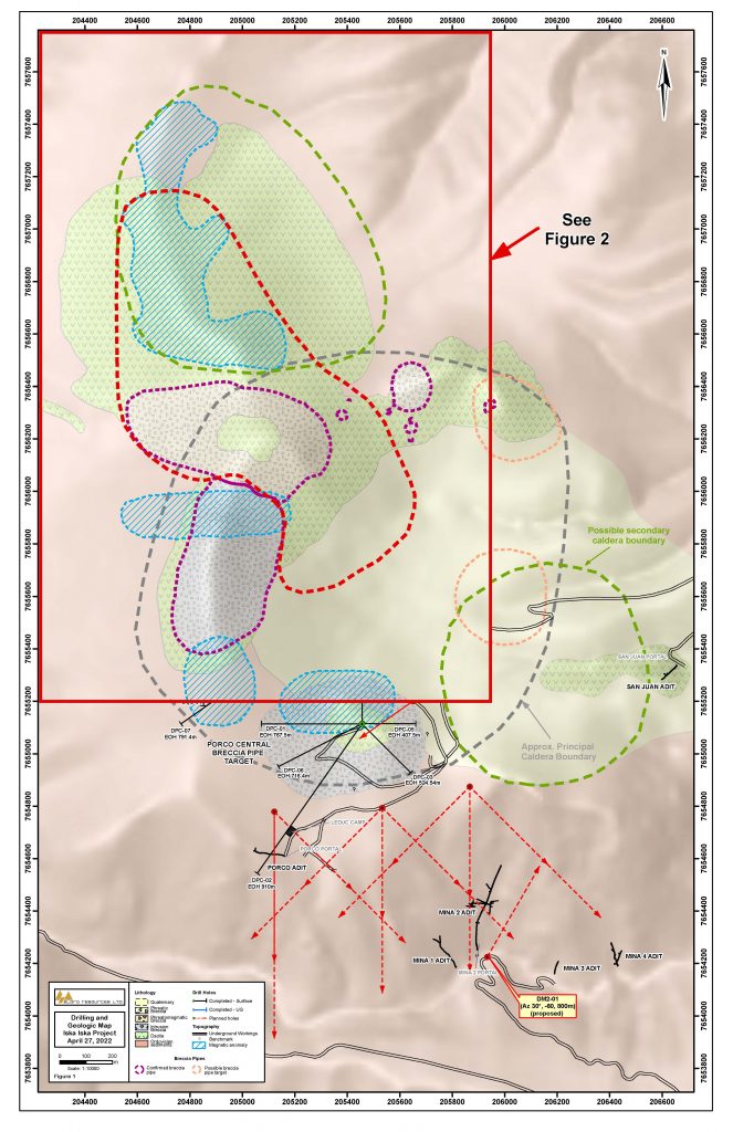
Figure 2: Geological Plan Map of the Santa Barbara Mineral Resource Target Area with Diamond Drill Holes
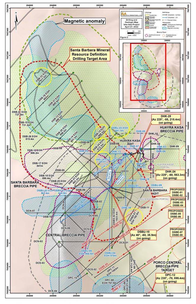
Figure 3: North-South Geological Section looking East across High Grade Target Area in Santa Barbara
![]()
Figure 4: Borehole Induced Polarization (IP) Mx Chargeability Section with Holes DSBU-05 and DSBU-06 looking east.
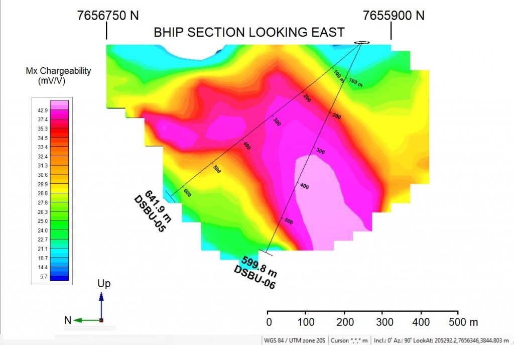
Table 4: Summary of Diamond Drill Holes Completed with Assays Pending and Drill Holes in Progress at Iska Iska from April 27, 2022 press release.
| SUMMARY DIAMOND DRILLING ISKA ISKA | |||||||
| Hole No. | Type | Collar Easting | Collar Northing | Elev | Azimuth | Angle | Hole length (m) |
| Surface Drilling Santa Barbara Breccia | |||||||
| DHK-24 | S | 205529.4 | 7656222.5 | 4153.4 | 225° | -60° | In Progress |
| DHK-25 | S | 205526.9 | 7656384.7 | 4178.1 | 225° | -55° | In Progress |
| Surface Drilling Northwest Extension Santa Barbara | |||||||
| DSB-16 | S | 204973.9 | 7657053.1 | 4147.1 | 225° | -65° | 862.0 |
| DSB-17 | S | 205136.3 | 7656770.8 | 4168.1 | 225° | -40° | 841.0 |
| DSB-18 | S | 205209.3 | 7656683.3 | 4172.5 | 225° | -40° | 890.4 |
| DSB-19 | S | 205209.9 | 7656684.0 | 4172.5 | 225° | -65° | 803.3 |
| DSB-23 | S | 205343.3 | 7656534.4 | 4176.1 | 225° | -40° | 863.2 |
| DSB-26 | S | 205044.5 | 7656982.6 | 4150.0 | 225° | -40° | 815.4 |
| DSB-27 | S | 205044.5 | 7656982.6 | 4150.0 | 225° | -65° | 800.4 |
| Subtotal | 5,875.7 | ||||||
| Underground Drilling Santa Barbara Adit | |||||||
| DSBU-04 | UG | 205283.7 | 7656071.6 | 4168.2 | 180° | -20° | 570.0 |
| DSBU-07 | UG | 205284.5 | 7656080.0 | 4167.1 | 235° | -50° | 800.9 |
| DSBU-08 | UG | 205284.5 | 7656080.0 | 4167.1 | 200° | -50° | 866.8 |
| DSBU-09 | UG | 205284.5 | 7656080.0 | 4167.1 | 90° | -60° | 904.0 |
| Subtotal | 3,141.7 | ||||||
| DSBU-10 | UG | 205284.5 | 7656080.0 | 4167.1 | 40° | -60° | In Progress |
| Surface Drilling South Extension Santa Barbara | |||||||
| DSBS-01 | S | 205300.0 | 7655563.0 | 4195.0 | 30° | -30° | 700.8 |
| DSBS-02 | S | 205300.0 | 7655563.0 | 4195.0 | 0° | -45° | 1023.4 |
| Subtotal | 1,724.2 | ||||||
| Porco Target Area – Surface Drill Program Testing Magnetic Inverse Model | |||||||
| DPC-07 | S | 205090.1 | 7655340.9 | 4310.0 | 235° | -60° | 791.4 |
| DPC-08 | S | 205585.0 | 7655423.6 | 4089.0 | 235° | -65° | 800.4 |
| DPC-09 | S | 205456.7 | 7655516.6 | 4125.0 | 180° | -75° | 1124.4 |
| DPC-10 | S | 205396.5 | 7655701.2 | 4148.0 | 225° | -60° | 1088.4 |
| DPC-11 | S | 205456.7 | 7655516.6 | 4125.0 | 235° | -70° | 1065.0 |
| Subtotal | 4,869.6 | ||||||
| DPC-12 | S | 205650.0 | 7655200.0 | 4100.0 | 235° | -70° | In Progress |
| Subtotal | 15,611.2 | ||||||
S = Surface UG=Underground; collar coordinates in metres; azimuth and dip in degrees. Total drilling completed since the start of the program on September 13, 2020 to December 17, 2021 is 40,468 m in 73 holes (26 underground holes and 47 surface holes). From re-start of drilling on January 17, 2022, an additional 11,196m has been completed bringing the overall total to 52,384m in 89 drill holes (30 underground drill holes and 59 surface drill holes) including 4 holes in progress.
Qualified Person
Dr. Osvaldo Arce, P. Geo., General Manager of Minera Tupiza, and a Qualified Person in the context of NI 43-101, has reviewed and approved the technical content of this news release. Dr. Bill Pearson, P.Geo., Executive Vice President Exploration Eloro, and who has more than 45 years of worldwide mining exploration experience including extensive work in South America, manages the overall technical program working closely with Dr. Osvaldo Arce, P.Geo., Manager of Minera Tupiza. Dr. Quinton Hennigh, P.Geo., Senior Technical Advisor to Eloro and Independent Technical Advisor, Mr. Charley Murahwi P. Geo., FAusIMM of Micon International Limited are regularly consulted on technical aspects of the project.
The magnetic survey was carried out by MES Geophysics using a GEM Systems GSM-19W Overhauser magnetometer. Dr. Chris Hale, P.Geo. and Mr. John Gilliatt, P.Geo. of Intelligent Exploration provided the survey design, preparation of the maps and interpretation from data processed and quality reviewed by Rob McKeown, P. Geo. of MES Geophysics. Messrs. Hale, Gilliatt and McKeown are Qualified Persons as defined under NI 43-101. Mr. Joe Mihelcic, P.Eng., P.Geo., of Clearview Geophysics, a QP under NI 43-101, completed the 3D magnetic inversion model in consultation with Dr. Hale and Mr. Gilliatt. The Borehole IP surveys are being carried out by MES Geophysics under the supervision of Dr. Hale and Mr. Gilliatt.
Eloro is utilizing both ALS and AHK for drill core analysis, both of whom are major international accredited laboratories. Drill samples sent to ALS are prepared in both ALS Bolivia Ltda’s preparation facility in Oruro, Bolivia and the preparation facility operated by AHK in Tupiza with pulps sent to the main ALS Global laboratory in Lima for analysis. More recently Eloro has had ALS send pulps to their laboratory at Galway in Ireland. Eloro employs an industry standard QA/QC program with standards, blanks and duplicates inserted into each batch of samples analyzed with selected check samples sent to a separate accredited laboratory.
Drill core samples sent to AHK Laboratories are prepared in a preparation facility installed and managed by AHK in Tupiza with pulps sent to the AHK laboratory in Lima, Peru. Au and Sn analysis on these samples is done by ALS Bolivia Ltda in Lima. Check samples between ALS and AHK are regularly done as a QA/QC check. AHK is following the same analytical protocols used as with ALS and with the same QA/QC protocols. Turnaround time continues to improve, as laboratories return to more normal staffing levels.
About Iska Iska
Iska Iska silver-tin polymetallic project is a road accessible, royalty-free property, wholly controlled by the Title Holder, Empresa Minera Villegas S.R.L. and is located 48 km north of Tupiza city, in the Sud Chichas Province of the Department of Potosi in southern Bolivia. Eloro has an option to earn a 99% interest in Iska Iska.
Iska Iska is a major silver-tin polymetallic porphyry-epithermal complex associated with a Miocene possibly collapsed/resurgent caldera, emplaced on Ordovician age rocks with major breccia pipes, dacitic domes and hydrothermal breccias. The caldera is 1.6km by 1.8km in dimension with a vertical extent of at least 1km. Mineralization age is similar to Cerro Rico de Potosí and other major deposits such as San Vicente, Chorolque, Tasna and Tatasi located in the same geological trend.
Eloro began underground diamond drilling from the Huayra Kasa underground workings at Iska Iska on September 13, 2020. On November 18, 2020, Eloro announced the discovery of a significant breccia pipe with extensive silver polymetallic mineralization just east of the Huayra Kasa underground workings and a high-grade gold-bismuth zone in the underground workings. On November 24, 2020, Eloro announced the discovery of the SBBP approximately 150m southwest of the Huayra Kasa underground workings.
Subsequently, on January 26, 2021, Eloro announced significant results from the first drilling at the SBBP including the discovery hole DHK-15 which returned 129.60 g Ag eq/t over 257.5m (29.53g Ag/t, 0.078g Au/t, 1.45%Zn, 0.59%Pb, 0.080%Cu, 0.056%Sn, 0.0022%In and 0.0064% Bi from 0.0m to 257.5m. Subsequent drilling has confirmed significant values of Ag-Sn polymetallic mineralization in the SBBP and the adjacent CBP. A substantive mineralized envelope which is open along strike and down-dip extends around both major breccia pipes. Continuous channel sampling of the Santa Barbara Adit located to the east of SBBP returned 442 g Ag eq/t (164.96 g Ag/t, 0.46%Sn, 3.46% Pb and 0.14% Cu) over 166m including 1,092 g Ag eq/t (446 g Ag/t, 9.03% Pb and 1.16% Sn) over 56.19m. The west end of the adit intersects the end of the SBBP.
Since the initial discovery hole, Eloro has released a number of significant drill results in the SBBP and the surrounding mineralized envelope which along with geophysical data has defined a target zone 1400m along strike, 500m wide and that extends to a depth of 600m. This zone is open along strike to the northwest and southeast as well as to the southwest. The Company’s nearer term objective is to outline a maiden NI 43-101 compliant mineral resource within this large target area. This work is advancing well with the mineral resource targeted to be completed in Q3 2022. Exploration drilling is also planned on other major targets in the Iska Iska Caldera Complex, including the Porco and Mina 2 areas.
About Eloro Resources Ltd.
Eloro is an exploration and mine development company with a portfolio of gold and base-metal properties in Bolivia, Peru and Quebec. Eloro has an option to acquire a 99% interest in the highly prospective Iska Iska Property, which can be classified as a polymetallic epithermal-porphyry complex, a significant mineral deposit type in the Potosi Department, in southern Bolivia. Eloro commissioned a NI 43-101 Technical Report on Iska Iska, which was completed by Micon International Limited and is available on Eloro’s website and under its filings on SEDAR. Iska Iska is a road-accessible, royalty-free property. Eloro also owns an 82% interest in the La Victoria Gold/Silver Project, located in the North-Central Mineral Belt of Peru some 50 km south of Barrick’s Lagunas Norte Gold Mine and Pan American Silver’s La Arena Gold Mine. La Victoria consists of eight mining concessions and eight mining claims encompassing approximately 89 square kilometres. La Victoria has good infrastructure with access to road, water and electricity and is located at an altitude that ranges from 3,150 m to 4,400 m above sea level.
Summit Royalties Ltd. (TSX-V: SUM) (OTCQX: SUMMF) is pleased to r... READ MORE
Silver Elephant Mining Corp. (TSX: ELEF) (OTCQB: SILEF) (FSE: 1P... READ MORE
Winshear Metals Corp. (TSX-V: WINS) (FRA: 9HR0) reports positive ... READ MORE
Barksdale Resources Corp. (TSX-V: BRO) (OTCQB: BRKCF) (FSE: 2NZ) ... READ MORE
Prospector Metals Corp. (TSX-V: PPP) (OTCQB: PMCOF) (FSE: 1ET) ... READ MORE


