


District Metals Corp. (TSX-V: DMX) (FSE: DFPP) is pleased to report assay results for the first three drill holes from the Phase II drill program at the high grade polymetallic Tomtebo Property located in the Bergslagen Mining District in south-central Sweden.
Drill holes TOM21-024 and -025 targeted the Steffenburgs zone down plunge from hole TOM21-001 (previously reported here), which returned 8.2 m at 20.94% ZnEq1 from 65.3 to 73.5 m (Figure 1). Hole TOM21-025 encountered 11.0 m of massive sulphide mineralization (211.4 to 222.4 m) located 118 m down plunge from TOM21-001. Hole TOM21-023A/B targeted a coincident gravity and magnetic anomaly located 1.0 km northeast from the historic Tomtebo Mine.
Highlights:
A drill hole cross section is shown in Figure 1, and drill assay results are shown in Table 1.
Rodney Allen, Technical Advisor for District, commented: “The intersections in holes TOM21-001 and TOM21-025 are classic volcanogenic massive sulphide (VMS) of good metal grade. As is normal for VMS, pyrite is the main sulphide mineral, followed in abundance by sphalerite (zinc), galena (lead) and chalcopyrite (copper), silver and gold. From interpretation of the geology of the Tomtebo area, we conclude that the massive sulphide lens formed at or just below the sea floor in the vent of a submarine volcano, 1.9 billion years ago. The southwest side of the massive sulphide lens grades into an extensive network of pyritic polymetallic vein mineralization that is interpreted to represent sulphide precipitated in the “feeder conduits”, below the massive sulphide (figure 1). The northeast side of the massive sulphide lens has a sharp contact with less mineralized hanging-wall volcanic rocks and is interpreted to be the original top of the massive sulphide body. The lateral edges of the massive sulphide are not yet well defined and we are uncertain whether these edges are the natural lateral termination of the original massive sulphide or whether they are tectonically truncated margins, for example faults. The down-plunge extent of the massive sulphide is open.
Like all rocks in the Tomtebo area, the massive sulphide lens has been stretched and folded by subsequent tectonic deformation. Each drill hole we put down in the Steffenburgs area provides more evidence of the shape and extent of this deformed massive sulphide body. From the data assembled so far, we interpret that the massive sulphide lens has been stretched into an elongate shape with a moderate to steep plunge to the north. The lens is directly adjacent to, and probably in part within, the “nose” or “closure” of a tight fold and consequently the shape of the lens is not expected to be a simple disk or ellipse. Current evidence suggests that the lens is narrow near surface but widens with depth.”
Garrett Ainsworth, CEO of District, commented: “Our drill assay results associated with visually strong sulphide mineralization encountered in holes TOM21-024 and -025 are even better than anticipated, and the high grade polymetallic lenses currently being delineated at the Steffenburgs zone are impressive. Hole -025 is an aggressive 118 m step out down plunge from hole -001 where down-hole electromagnetic surveys and whole rock geochemistry will provide important inputs to our 3D model that will assist with continuing to step out aggressively at depth.”
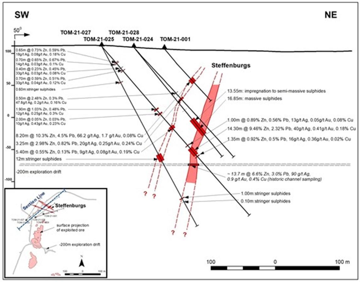
Figure 1: Cross Section Looking Northwest at Steffenburgs Zone
Table 1: Tomtebo Drill Assay Results
| Drill Hole | Depths and Interval | Assay Results | ||||||||||
| Hole ID | Azimuth | Dip | Total Depth (m) | From (m) | To (m) | Interval (m) | Ag (g/t) | Zn (%) | Pb (%) | Au (g/t) | Cu (%) | ZnEq (%) |
| TOM21-023A/B | 145 | -45 | 399.00 | No Significant Results | ||||||||
| TOM21-024 | 70 | -45 | 239.20 | 99.30 | 99.80 | 0.50 | 47.80 | 2.48 | 0.30 | 0.20 | 0.16 | 4.97 |
| 110.55 | 113.80 | 3.25 | 20.18 | 2.98 | 0.82 | 0.25 | 0.24 | 5.55 | ||||
| TOM21-025 | 52 | -48 | 351.00 | 33.30 | 33.95 | 0.65 | 18.45 | 0.73 | 0.59 | 0.08 | 0.18 | 2.43 |
| 35.00 | 35.70 | 0.70 | 13.55 | 0.65 | 0.67 | 0.03 | 0.10 | 1.93 | ||||
| 44.90 | 45.30 | 0.40 | 33.40 | 0.23 | 0.45 | 0.03 | 0.08 | 1.79 | ||||
| 49.90 | 50.60 | 0.70 | 32.50 | 0.59 | 0.51 | 0.04 | 0.12 | 2.27 | ||||
| 129.15 | 131.05 | 1.90 | 12.10 | 1.03 | 0.48 | 0.25 | 0.30 | 3.25 | ||||
| 138.00 | 140.00 | 2.00 | 9.69 | 0.05 | 0.03 | 0.43 | 0.23 | 2.13 | ||||
| 164.80 | 170.20 | 5.40 | 9.22 | 0.55 | 0.13 | 0.08 | 0.19 | 1.62 | ||||
| 204.00 | 205.00 | 1.00 | 12.75 | 0.89 | 0.56 | 0.05 | 0.08 | 2.06 | ||||
| 210.00 | 224.30 | 14.30 | 40.00 | 9.46 | 2.32 | 0.41 | 0.18 | 14.15 | ||||
| incl. | 210.80 | 222.40 | 11.60 | 46.60 | 11.50 | 2.72 | 0.45 | 0.20 | 16.89 | |||
| incl. | 212.80 | 219.40 | 6.60 | 46.12 | 15.95 | 3.01 | 0.49 | 0.16 | 21.59 | |||
| 226.65 | 228.00 | 1.35 | 16.30 | 0.92 | 0.50 | 0.36 | 0.02 | 2.87 | ||||
Notes:
Drill Hole Summaries
TOM21-023B (Northeast gravity target):
Hole TOM21-023B was drilled at an angled orientation (-45° dip) to the southeast (145° azimuth). It was designed to test a blind gravity high anomaly with coincident magnetic and conductive anomalies located 1 km northeast along trend from the historic Tomtebo Mine. Hole TOM21-023A was lost at a depth of 42.0 m, and TOM21-023B was the re-start hole.
After 16.0 m of overburden, the hole intersected weakly altered (silicified, biotite, and albite) felsic volcanic rocks with no sulphides that was intercalated with mafic dykes from 16.0 to 217.0 m. A dyke swarm with an increased magnetic response comprised of amphibolite, porphyritic, and diabase dykes within an interbedded silicified volcanic ash was encountered from 217.0 to 244.0 m that transitioned back into weakly altered felsic volcanic rocks from 244.0 to 275.0 m. This package was underlain by an undifferentiated intrusive unit from 275.0 to 354.0 m, which appears to be of dioritic composition, and is denser than the surrounding felsic volcanic rocks. From 354.0 to 386.0 a weakly altered felsic volcanic rock with meter-scale mafic dykes is present, where a dense mafic intrusion (gabbro?) with intersecting mafic dykes persists from 386.0 to the end of hole depth at 399.0 m. The magnetic and gravity anomalies have been explained by the slightly magnetic dyke swarm and dense diorite/gabbro intrusions, respectively.
TOM21-024 (Steffenburgs zone):
Hole TOM21-024 was drilled at an angled orientation (-45° dip) to the east-northeast (70° azimuth). It was designed to step out 40 m down plunge from massive sulphides encountered in hole TOM21-001, which returned 8.2 m at 10.3% Zn, 4.5% Pb, 66.2 g/t Ag, 1.7 g/t Au, and 0.08% Cu (65.3 to 73.5 m).
After 18.8 m of overburden, the hole intersected moderately altered felsic volcanic rocks with trace pyrite (1 to 3%) from 18.8 to 85.0 m. A porphyritic mafic dike was encountered from 85.0 to 92.55 m. Moderately to strongly altered felsic rock with increasing pyrite, pyrrhotite and magnetite content was intersected between 92.55 to 210.4 m highlighted by vein/stringer sulphides from 92.55 to 98.2 m, and disseminated to semi-massive sulphides (pyrrhotite, pyrite, sphalerite, chalcopyrite, galena) from 109.2 to 113.8 m. Weakly to moderately altered felsic rock with trace pyrite (0.1%) persisted from 210.4 to the end of hole depth at 239.2 m. Hole TOM21-024 was drilled just south of the northwest plunging massive sulphide lens encountered in hole TOM21-001 and -025, so a follow up hole in this area is planned.
TOM21-025 (Steffenburgs zone):
Hole TOM21-025 was drilled at an angled orientation (-48° dip) to the northeast (52° azimuth). It was designed to step out 118 m down plunge from massive sulphides encountered in hole TOM21-001, which returned 8.2 m at 10.3% Zn, 4.5% Pb, 66.2 g/t Ag, 1.7 g/t Au, and 0.08% Cu (65.3 to 73.5 m).
After 15.9 m of overburden, the hole intersected moderately altered felsic volcanic rocks with trace pyrite (1%) from 15.9 to 136.0 m with occasional meter-scale mafic dykes. Moderately to strongly altered felsic rock with increasing pyrite, pyrrhotite and magnetite content was intersected between 136.0 to 211.4 m. Massive sulphides (sphalerite, galena, pyrite, pyrrhotite, chalcopyrite) were intersected from 211.4 to 222.4 m. This high grade and very dense mineralized intercept is underlain by moderately altered felsic volcanic rocks with occasional meter-scale mafic dykes from 222.4 to 260.0 m where weakly altered felsic volcanic rocks continue from 260.0 m to the end of hole depth at 350.0 m. Hole TOM21-025 represents the best drill assay interval intersected at the historic Tomtebo Mine to date.
References
1 Metal prices used in USD for the ZnEq calculation were based on Ag $15.00/oz, Au $1650/oz, Cu $2.15/lb, Zn $0.85/lb, and Pb $0.75/lb. ZnEq equals = Zn% + (Ag g/t × 0.0257) + (Au g/t x 2.831) + (Cu% × 2.529) + (Pb% × 0.882). The use of ZnEq is to calculate cut-off grades for exploration purposes, and no adjustments were made for metal recovery.
Technical Information
All scientific and technical information in this news release has been prepared by, or approved by Garrett Ainsworth, PGeo, President and CEO of the Company. Mr. Ainsworth is a qualified person for the purposes of National Instrument 43-101 – Standards of Disclosure for Mineral Projects.
The drill core reported in this news release was logged and prepared at the District Metals AB core facility in Säter, Sweden before submittal to ALS Geochemistry in Malå, Sweden where the NQ-size drill core is cut, bagged, and prepared for analysis. Sample pulps were sent to ALS Geochemistry in Ireland (an accredited mineral analysis laboratory) for analysis. Samples were analyzed using a multi-element ultra trace method combining a four-acid digestion with ICP-MS analytical package (“ME-MS61”). Over limit sample values were re-assayed for: (1) values of copper >1%; (2) values of zinc >1%; (3) values of lead >1%; and (4) values of silver >100 g/t using the high-grade material ICP-AES analytical package (“ME-OG62”). Additional over limit sample values were re-assayed for: (1) values of zinc >30%; (2) values of lead >20% using the high precision analysis of base metal ores AAS analytical package (“Zn, Pb-AAORE”). Gold, platinum, and palladium were analyzed using the 30 g lead fire assay with ICP-AES finish analytical package (“PGM-ICP23”). Certified standards, blanks, and duplicates were inserted into the sample shipment to ensure integrity of the assay process. Selected samples were chosen for duplicate assay from the coarse reject and pulps of the original sample. No QA/QC issues were noted with the results reported.
Some of the data disclosed in this news release is related to historical drilling results. District has not undertaken any independent investigation of the sampling nor has it independently analyzed the results of the historical exploration work in order to verify the results. District considers these historical drill results relevant as the Company is using this data as a guide to plan exploration programs. The Company’s current and future exploration work includes verification of the historical data through drilling.
Mr. Ainsworth has not verified any of the information regarding any of the properties or projects referred to herein other than the Tomtebo Property. Mineralization on any other properties referred to herein is not necessarily indicative of mineralization on the Tomtebo Property.
About District Metals Corp.
District Metals Corp. is led by industry professionals with a track record of success in the mining industry. The Company’s mandate is to seek out, explore, and develop prospective mineral properties through a disciplined science-based approach to create shareholder value and benefit other stakeholders.
The advanced exploration stage Tomtebo Property is located in the Bergslagen Mining District of south-central Sweden is the Company’s main focus. Tomtebo comprises 5,144 ha and is situated between the historic Falun Mine and Boliden’s Garpenberg Mine that are located 25 km to the northwest and southeast, respectively. Two historic polymetallic mines and numerous polymetallic showings are located on the Tomtebo Property along an approximate 17 km trend that exhibits similar geology, structure, alteration and VMS/SedEx style mineralization as other significant mines within the district. Mineralization that is open at depth and along strike at the historic mines on the Tomtebo Property has not been followed up on, and modern systematic exploration has never been conducted on the Property.
Delta Reports New Gold Intercept at Nova Target in Wedge Area, 4 ... READ MORE
Silver One Resources Inc. (TSX-V: SVE) (OTCQX: SLVRF) (FSE: BRK1)... READ MORE
Exceptional grades of Titanium, Vanadium and Iron in all 15 drill... READ MORE
Intersection is within 33 metres from surface and contained in a ... READ MORE
Further production growth to one million ounces annually expected... READ MORE


