








Corcel Exploration Inc. (CSE: CRCL) (OTCQB: CRLEF) is pleased to announce assay results from two drill holes from the recently completed Phase I drill program at the Yuma King Project located in west-central Arizona.
Drill hole YK26-002 intersected skarn-hosted copper-gold mineralization from a 45-metre step-out to the east of drill hole YK26-001, while YK26-003 intersected skarn-hosted copper-gold mineralization from a 350-metre step-out to the west of drill hole YK26-001. Drill hole YK26-001 previously intersected 56.65 metres of 1.07% Cu, 0.79 g/t Au, 7.1 g/t Ag, and 180 ppm Mo (see news release dated June 1, 2026).
Results are pending from three additional drill holes. The Phase I drill program totaled 1,087 metres across six drill holes and tested more than 500 metres of strike-length.
Highlights
YK26-002:
YK26-003: Intersected Cu-Au mineralization in a 350 m step-out to the west
“These results demonstrate continuity of copper-gold skarn mineralization across a broader footprint than previously recognized,” commented Corcel CEO, Jon Ward. “Importantly, Hole YK26-03 confirmed mineralization 350 metres west of Hole YK26-01, while Hole YK26-02 extended the higher-grade oxide skarn eastward. Combined with our geophysical data, the program continues to strengthen our interpretation that Yuma King represents a district-scale mineralized system.
The mineralization remains largely open to the north under cover, towards the North Skarn target. As we await the results from the last three holes of this program, we’re advancing plans to test this target, as well as two other completely untested copper-gold targets nearby at Three Musketeers and Yuma King West, in a future drill program.”
2026 Yuma King Drill Program
The Phase I drill program at the Yuma King project, near Salome, Arizona, consisted of 1,087 metres across six drill holes (Figure 1, Table 2). The remaining three drill holes are currently at the lab and will be released once assays are received, compiled, and interpreted.
Drill hole YK26-002 was designed as a 45-metre step-out to the east from YK26-001 and from historical drill intercepts to test the extension of the mineralized, oxidized skarn. The hole was drilled toward the northeast at a dip of -50o. Based on geological modeling and a review of historical drilling, YK26-002 was planned to expand the known mineralization up-dip to the east from historical mine workings (Figures 1 and 2). YK26-002 intersected a broad zone of near-surface copper-gold-silver mineralization beginning at 30 metres, including 40.25 metres of 0.52% Cu, 0.4 g/t Au, and 4.49 g/t Ag1 (Table 1). Mineralization within this interval consists primarily of copper oxides hosted in copper skarn/replacement style mineralization. The hanging wall, composed of monzonite porphyry, is strongly anomalous in copper, gold, and molybdenum, indicating a connection to a possibly more expansive porphyry-style mineralized system. Results from drill hole YK26-002 compare favorably with historical drilling from the 2006 drill program (e.g., 45.4 metres of 0.78% Cu, 0.53 g/t Au, and 6.3 g/t Ag in drill hole YK-001A, see news release dated October 7, 2025), supporting the continuity of the mineralized oxide skarn along strike and up-dip.
Drill hole YK26-003 was drilled 350-metres to the west of YK26-001 and was drilled to the north at a dip of -60°. The primary objective was to drill the magnetic anomaly to the north, but access limitations allowed only the southern margin of this anomaly to be tested. The drill hole intersected 32 metres of 0.17% Cu, 0.04 g/t Au, and 2.5 g/t Ag1 (Table 1) beginning at 25 metres down hole. This mineralization is similar in tenor to that in historical drill hole AV-1 which encountered 27.4 metres of 0.14% Cu, 0.08 g/t Au, and 1.1 g/t Ag in 2011 (see news release dated October 7, 2025), over 400 metres to the north of YK26-001 and the historical Yuma King mine. The successful step-out to the west and similar mineralization in hole AV-1 to the north may indicate the potential for a large mineralized footprint, still open in multiple directions including towards the untested North Skarn target.
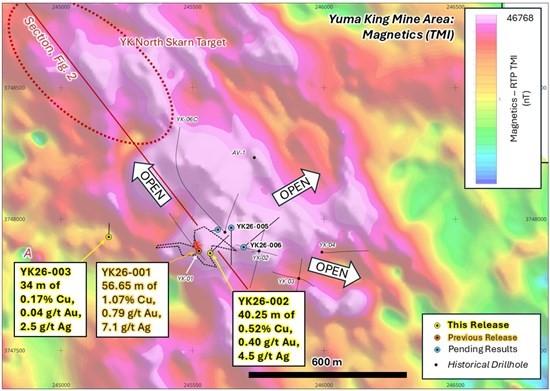
Figure 1. Map showing the collar location of drill holes YK26-002 and YK26-003, in relation to recently completed holes with pending results and to historical drill holes. Location of historical underground workings is shown projected to surface.
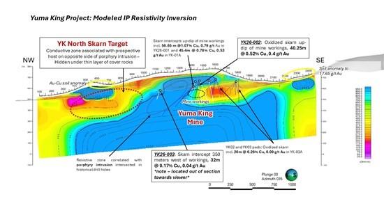
Figure 2. Section showing the IP resistivity with down-hole assay results from historical drill holes and YK26-001, YK26-002, and YK26-003 that are vectoring northwest towards the recently identified untested North Skarn Target.
Table 1. Assay results from drill holes YK26-001 through YK26-003
| Drillhole | Intercept From – To (m) |
Intercept Thickness1 (m) | Cu (%) | Au (g/t) | Ag (g/t) | Mo (ppm) | |
| YK26-001* | 3.35 | 60 | 56.65 | 1.07 | 0.79 | 7.1 | 180 |
| including | 24 | 31.85 | 7.85 | 2.28 | 1.14 | 6.8 | 266 |
| including | 45 | 53.8 | 8.8 | 2.07 | 1.85 | 20.5 | 312 |
| YK26-002 | 30 | 70.25 | 40.25 | 0.52 | 0.4 | 4.49 | 85 |
| including | 44.25 | 53 | 8.75 | 0.74 | 0.46 | 3.72 | 46 |
| including | 54.4 | 70.25 | 15.85 | 0.7 | 0.59 | 8.1 | 152 |
| YK26-003 | 25 | 57 | 32 | 0.174 | 0.04 | 2.47 | 25 |
| including | 33 | 42 | 9 | 0.25 | 0.09 | 3.5 | 7 |
| including | 46.6 | 53.93 | 7.33 | 0.3 | 0.04 | 4.2 | 107 |
*From previous news release dated June 1, 2026
Table 2. Collar information for Phase I drill program
| Drillhole | Easting | Northing | Elevation | Azimuth | Dip | Total Depth |
| YK26-001 | 245524 | 3747879 | 640.77 | 341 | -50 | 91.74 |
| YK26-002 | 245567 | 3747870 | 650.38 | 46 | -50 | 152.4 |
| YK26-003 | 245181 | 3747932 | 609.42 | 2 | -60 | 103.3 |
| YK26-004 | 245596 | 3747960 | 690.35 | 258 | -70 | 92.96 |
| YK26-005^ | 245647 | 3747967 | 691.33 | 180 | -55 | 127.41 |
| YK26-005A | 245647 | 3747967 | 691.33 | 180 | -55 | 245.36 |
| YK26-006 | 245694 | 3747893 | 700.42 | 50 | -50 | 274.32 |
^Hole lost and re-drilled as YK26-005A and was not sampled.
Sampling, Quality Assurance/Quality Control
All sampling was conducted under the supervision of Corcel’s geologists, and all drill core analytical results have been monitored through the Company’s quality assurance and quality control program. The drill core was sawn in half at Corcel’s dedicated and secure core logging and processing facility near Parker, Arizona.
Half of the drill core was sampled and shipped by a bonded courier in sealed and secured woven polyester bags to Agat Laboratories in Calgary, Alberta. Core samples were prepared using standard preparation procedures 200-078 and 200-087 which involve crushing the sample to 80% less than 2mm, followed by a riffle split of 250g, and then a pulverised split to better than 85%, passing 75 microns.
Following sample preparation, the pulps were sent to the Agat Laboratories in Calgary, Alberta for analysis. Agat is registered to ISO/IEC 17025:2017 accreditations for laboratory procedures.
Drill core samples were analyzed for 48 elements, including Cu, Ag, Mo by ICP-OES/MS on a 0.2-gram aliquot using a four-acid digestion (method 201-071 and 201-470 for over-limit results). Gold was analyzed by fire assay on a 50-gram aliquot with an AAS (Atomic Absorption Spectroscopy) finish (method 202-551).
In addition to Agat Laboratories QA/QC protocols, Corcel implements a rigorous internal QA/QC program that includes the insertion of field and lab duplicates, certified reference materials (standards prepared by an independent lab) and blanks into the sample stream. Data verification of the analytical results includes a statistical analysis of the standards and blanks that must pass certain parameters for acceptance to ensure accurate and verifiable results, and the procedures and results are considered acceptable.
Technical Disclosure
Roy Greig, Ph.D., P.Geo, a Qualified Person as defined in National Instrument 43-101 Standards of Disclosure for Mineral Projects, and advisor to Corcel Exploration Inc. has reviewed and approved the technical information in this news release.
About Corcel Exploration Inc.
Corcel Exploration is a mineral resource company engaged in the acquisition and exploration of precious and base metals properties throughout North America. The Company has entered a long-term lease agreement to acquire the Yuma King Cu-Au project in Arizona, which spans a district-scale land position of 3,200 hectares comprising 515 unpatented federal mining claims in the Ellsworth Mining District, including the past-producing Yuma King Mine which saw underground production of copper, lead, gold and silver between 1940 and 1963.
Brutus Mining Inc. (CSE: BRU) (FSE: ZI3) is pleased to announce that it has closed its non-brokered ... READ MORE
Jaguar Uranium Corp. (NYSE American: JAGU) is pleased to announce an independent Mineral Resource E... READ MORE
Auro Metals Inc. (TSX-V: AURO) (OTCQB: AURFF), is pleased to announce the assay results of the fina... READ MORE
Endeavour Silver Corp. (NYSE: EXK) (TSX: EDR) is pleased to announce that repairs to the primary bal... READ MORE
Scorpio Gold Corp. (NASDAQ: SGLD) (TSX-V: SGLD) (OTCQB: SRCRF) (FSE: RY9) is pleased to announce re... READ MORE


