








Contango Silver and Gold Inc. (NYSE American: CTGO) (TSX: CTGO) is pleased to announce initial gold assay results from the 2026 surface diamond drilling program at the Lucky Shot Project in Alaska, provide an update on underground exploration development, and report two previously unmodeled KM-style mineralized vein structures encountered during development of the West Drift Extension.
Highlights
Rick Van Nieuwenhuyse, the Company’s Chief Executive Officer said, “These initial surface drill results validate our systematic approach to defining the Coleman vein geometry, even as our underground crews push forward on developing the access needed for our next underground drilling phase. Hitting 2.5 meters of nearly 3 ounce per tonne high-grade gold in LSS26016-along with multiple mineralized intercepts from Pad C-adds critical data that sharpens our geologic model. Furthermore, extending the West Drift and intercepting additional high-grade KM-style vein structures gives us immediate, high-priority targets that we can now drill efficiently from underground.”
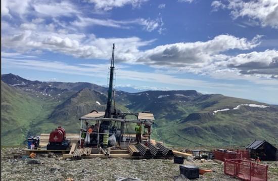
Figure 1. Helicopter-supported diamond core drill operating from Coleman Pad D on Lucky Shot Ridge.
2026 Lucky Shot Surface Drill Program
The 2026 Lucky Shot surface diamond drilling program commenced on June 22, 2026 and is planned to total approximately 6,000 meters. As of August 27, 2026, the Company had completed approximately 5,700 meters in 27 drill holes from five drill pads (Figures 1, 2). The program is designed to infill portions of the Coleman area within the current geological and mineral resource model and to complete step-out drilling that tests the interpreted structural relationship between the Coleman and Lucky Shot vein systems.
This release reports the first assay batch from seven holes drilled from Coleman Pads C and D. Six holes returned the selected significant intervals reported in Table 1; LSS26015 is identified as having no significant interval selected for reporting. Assays from the balance of the program remain pending and will be released as they are received, reviewed and validated.
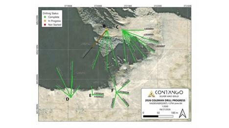
Figure 2. Plan view of the 2026 Coleman surface drill program showing drill-pad and drill-hole locations and drilling status as of August 27, 2026. Completed holes are shown in green, the hole in progress in orange, and holes not started in red.
Initial Surface Drill Results
Table 1 summarizes selected significant mineralized intervals from the first batch of assays. All interval lengths are downhole core lengths. True widths are not yet known and may be materially different from the reported interval lengths.
Coleman Pad C
Drilling from Pad C tested the lower, down-dip portions of the northeastern Coleman vein system closest to the Lucky Shot Fault. The drilling provided additional control on the near-surface location of the fault and improved the projection of the Lucky Shot Fault intercepts identified during the initial phase of underground drilling. Results support the interpreted down-dip continuation of Coleman veins 1, 3 and 4 toward the fault and identified additional mineralized splays adjacent to the fault (Figure 3).
Selected Pad C results include 0.50 meters grading 81.57 g/t Au in LSS26003; 0.37 meters grading 8.30 g/t Au, 0.39 meters grading 6.15 g/t Au and 0.51 meters grading 5.82 g/t Au in LSS26002; and multiple intervals in LSS26004, including 1.26 meters grading 3.73 g/t Au, 2.08 meters grading 2.39 g/t Au, including 0.30 meters grading 14.72 g/t Au, and 1.32 meters grading 2.54 g/t Au, including 0.31 meters grading 7.64 g/t Au.
Table 1. Selected significant surface drill assay results – Coleman Pads C and D
| Drill Station | Hole ID | From (m) | To (m) | Length (m) | Au (g/t) | Vein | Visible Gold Observed* |
| CLMN – C | LSS26002 | 160.40 | 160.77 | 0.37 | 8.30 | Splay of LS Fault | YES |
| 186.91 | 187.30 | 0.39 | 6.15 | CLMN 3 | YES | ||
| 197.46 | 197.97 | 0.51 | 5.82 | CLMN 3 or 4 | YES | ||
| LSS26003 | 202.00 | 202.50 | 0.50 | 81.57 | CLMN 1 | YES | |
| 231.40 | 231.70 | 0.30 | 13.14 | Undesignated | |||
| LSS26004 | 180.00 | 181.26 | 1.26 | 3.73 | Splay of LS Fault | ||
| (includes) | 180.00 | 180.30 | 0.30 | 6.41 | Splay of LS Fault | ||
| 194.78 | 196.86 | 2.08 | 2.39 | CLMN 3 | YES | ||
| (includes) | 196.56 | 196.86 | 0.30 | 14.72 | CLMN 3 | YES | |
| 208.50 | 209.82 | 1.32 | 2.54 | CLMN 3 or 4 | |||
| (includes) | 208.50 | 208.81 | 0.31 | 7.64 | CLMN 3 or 4 | ||
| LSS26005 | 214.60 | 215.43 | 0.83 | 2.09 | CLMN 3 or 4 | ||
| CLMN – D | LSS26014 | 177.10 | 177.70 | 0.60 | 2.05 | CLMN 1 | YES |
| 187.35 | 187.90 | 0.55 | 2.98 | CLMN 4 | NO | ||
| LSS26015 | N/S | ||||||
| LSS26016 | 195.40 | 197.85 | 2.45 | 86.05 | CLMN 2 | YES | |
| (includes) | 195.40 | 196.20 | 0.80 | 244.30 | CLMN2 | YES | |
| (includes) | 197.55 | 197.85 | 0.30 | 49.96 | CLMN2 | YES | |
| 206.53 | 207.02 | 0.49 | 2.62 | CLMN 1 | |||
Notes: All reported intervals are downhole core lengths; true widths are not yet known and may be materially different. Composite intervals are reported as length-weighted averages. N/S means no significant interval selected for reporting. Selected intervals are those interpreted to represent targeted or newly recognized mineralized vein structures and are included because they are relevant to the current geological interpretation. *Visible-gold observations are qualitative observations made during core logging. They do not necessarily indicate higher gold grades, mineral continuity, metallurgical performance or economic significance. Gold assays are the only quantitative measure of gold content. Blank entries indicate no visible gold was observed.
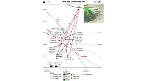
Figure 3. Inclined section through Coleman Pad C looking east, showing reported Au assay results, the current and projected vein interpretation, and the updated interpretation of the Lucky Shot Fault.
Coleman Pad D
Drilling from Pad D targets the central Coleman vein system to improve resolution of the multiple subparallel veins and associated fault controls. LSS26016 returned 2.45 meters grading 86.05 g/t Au from the interpreted Coleman 3 extension, including 0.80 meters grading 244.30 g/t Au and 0.30 meters grading 49.96 g/t Au. The Pad D interpretation also incorporates the newly modeled West Coleman Fault (Figure 4).
Dave Larimer, CPG, and the Company’s Vice President Exploration stated, “The initial Coleman results materially improve our structural understanding of the system. Pad C drilling provides additional control on the Coleman veins as they approach the Lucky Shot Fault, while Pad D has confirmed high-grade mineralization within the interpreted Coleman 3 extension. Underground, the two newly encountered KM-style structures show that the local vein architecture is more complex than the current model. Our next step is disciplined follow-up through detailed mapping, systematic sampling and drilling to determine geometry, continuity and significance.”
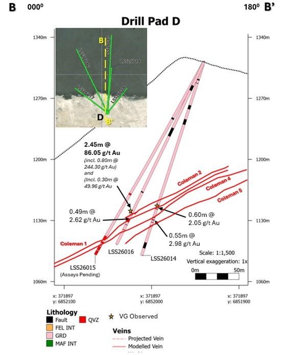
Figure 4. North-South section through Coleman Pad D looking east, showing reported Au assay results, the current and vein interpretation
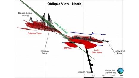
Figure 5. Oblique view looking north across the Lucky Shot deposit area, showing 2026 surface drilling, historic, current and planned underground development, and the interpreted principal vein and fault systems.
Underground Exploration Development
Underground exploration development continued during the quarter on a two-shift, 24-hour schedule. To date, 332 meters of the planned 830 meters of lateral development have been completed, representing approximately 40% of the program. Three headings are being advanced concurrently to optimize the mining cycle and overall development rate (Figure 6).
The 2090W West Drift Extension has been completed to design and is being prepared for the next phase of underground drilling. Planned development will continue in the 2070E heading, the Enserch Tunnel extension and the 2300E heading. Subject to operating conditions and continued progress, the Company currently expects to complete this phase of underground exploration development during the middle of the fourth quarter of 2026.
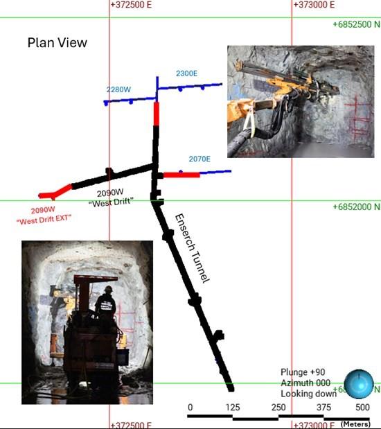
Figure 6. Plan view showing underground exploration development completed to date in red and planned or in-progress development in blue. The inset photograph shows the 2090W West Drift Extension during the exploration drift cycle.
Additional KM-Style Mineralization Encountered in the West Drift Extension
The West Drift Extension was designed to advance approximately 100 meters westward beneath the previously identified KM Vein with previously reported assays including 5.92 meters @ 60.22 and 0.31 meters @ 99.75 g/t Au in downhole lengths (see Contango’s press release dated March 2, 2026). This exploration advancement will establish short-distance underground drill access to this target zone. Initial development rounds indicated that the modeled KM Vein projected above the planned development heading. As the drift continued westward, two previously unmodeled mineralized vein structures were encountered. The structures have orientations, shearing and mineralization characteristics similar to the KM Vein with true widths approximately 0.5 meters. These have been tentatively designated KM2 and KM3 (Figure 7).
It is not yet known whether KM2 and KM3 are separate vein structures or local splays of the KM Vein. Development muck from the mineralized rounds was segregated into a dedicated stockpile, and detailed underground mapping identified frequent visible gold within the encountered vein material. Follow-up mapping, systematic channel sampling and drilling will be required to determine geometry, continuity, grade distribution and the relationship of these structures to the KM Vein.
Three sampling approaches were used for preliminary characterization: (i) three selectively collected hand samples of vein-material approximately four kilograms each; (ii) two approximately five-kilogram samples of the less-than-one-centimeter fines fraction from the segregated stockpile; and (iii) two approximately five-kilogram composite stockpile samples containing a mixture of vein material, fines and waste rock. The results are shown in Table 2. Because the samples are selective, limited in number, and not collected on a systematic channel or bulk-sampling basis, they must not be interpreted as representative of the grade of the vein structures, development rounds or stockpile.
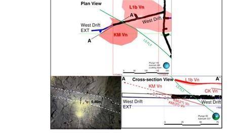
Figure 7. Plan and cross-sectional views looking north across the West Drift Extension, showing the interpreted KM-oriented mineralized vein structures encountered during development. The inset photograph shows approximately 0.46-meter true width of mineralized material.
Table 2. Selective underground hand and stockpile sample results – West Drift Extension
| Sample ID | Au (g/t) | Sample description |
| 5007904 | 101.75 | Vein-material hand sample |
| 5007905 | 395.10 | Vein-material hand sample |
| 5007906 | 74.34 | Vein-material hand sample |
| 5007907 | 5.26 | Fines from mineralized stockpile |
| 5007908 | 1.80 | Fines from mineralized stockpile |
| 5007909 | 0.72 | Composite stockpile sample |
| 5007910 | 13.27 | Composite stockpile sample |
Notes: The hand samples were selectively collected from visually mineralized vein material. The fines and composite stockpile samples were collected for preliminary characterization of segregated development muck. These samples are not systematic channel samples and are not representative of the entire vein, development round or stockpile. The results do not establish width, continuity, bulk grade, mineral resources or mineral reserves.
Cautionary Note Regarding Exploration Results
The Company cautions that drill intercept lengths reported in this release are downhole core lengths. True widths are not yet known and may be materially different from reported interval lengths. Visible-gold observations are qualitative geological observations and do not necessarily correlate with higher gold grades, mineral continuity, metallurgical performance or economic significance. Gold assay results derived from laboratory analysis are the only quantitative measure of gold content.
The underground hand, fines and composite stockpile samples reported in Table 2 are selective and non-representative. They do not establish a bulk grade, mining width, continuity, mineral resource or mineral reserve and should not be extrapolated beyond the specific material sampled.
Lucky Shot is an exploration-stage property. No mineral reserves have been declared for the Lucky Shot Project, and the work described in this release is exploratory in nature. The exploration results reported in this release do not demonstrate economic viability.
Quality Assurance and Quality Control
Contango’s drilling and sampling programs are conducted in accordance with industry best practices and applicable SEC Regulation S-K 1300 requirements. Drill core is systematically logged, photographed and sampled under the supervision of the Company’s Qualified Person.
Quality assurance and quality control procedures include the regular insertion of certified reference materials, blanks and duplicate samples into the analytical stream. Mineralized drill-core intervals are sampled as whole core, with shoulder samples extending beyond mineralized zones where appropriate. Samples are sealed and transported to the laboratory under documented chain-of-custody procedures.
Analytical testing was performed by Bureau Veritas North America, with sample preparation conducted in Fairbanks, Alaska. Gold analyses for the samples reported in this release were completed using a two-cycle PhotonAssay™ method by Paragon Geochemical in Vancouver, British Columbia. The published lower detection limit for the two-cycle PhotonAssay method is 0.015 g/t Au and the upper detection limit is 355 g/t Au. Samples returning gold values above the upper detection limit are re-assayed using a 50-gram charge fire assay with gravimetric finish through Bureau Veritas. Samples also undergo multi-element ICP-MS analysis to quantify minor- and trace-element associations.
Qualified Person
The scientific and technical information contained in this news release has been reviewed and approved by Dave Larimer, CPG, VP Exploration for Contango, who is a Qualified Person as defined by SEC Regulation S-K 1300. Mr. Larimer is not independent of the Company.
ABOUT CONTANGO
Contango is a NYSE American and TSX listed company that engages in the exploration for and development and production of gold and associated minerals in Alaska and in the Golden Triangle in British Columbia. Contango holds a 30% interest in the Peak Gold JV, which leases approximately 675,000 acres of land for exploration and development on the Manh Choh project, with the remaining 70% owned by KG Mining (Alaska), Inc., an indirect subsidiary of Kinross Gold Corporation, operator of the Peak Gold JV. The Company and its subsidiaries also have (i) a lease on the Johnson Tract project, which consists of mineral rights to approximately 21,000 acres located near tidewater, 125 miles southwest of Anchorage, Alaska, from the underlying owner, CIRI, (ii) a lease on the Lucky Shot project, which consists of mineral rights to approximately 8,600 acres of State of Alaska and patented mining claims located in the Willow Mining District about 75 miles north of Anchorage, Alaska, from the underlying owner, Alaska Hardrock Inc., (iii) mineral rights to approximately 145,000 acres of State of Alaska mining claims, and (iv) mineral rights to approximately 11,700 acres of State of Alaska mining claims and upland mining leases, all of which give Contango the exclusive right to explore and develop minerals on these lands, and (v) mineral tenures of approximately 247,000 acres (100,000 ha) located in and around the Kitsault Valley in the Golden Triangle of northwest British Columbia.
Brutus Mining Inc. (CSE: BRU) (FSE: ZI3) is pleased to announce that it has closed its non-brokered ... READ MORE
Jaguar Uranium Corp. (NYSE American: JAGU) is pleased to announce an independent Mineral Resource E... READ MORE
Auro Metals Inc. (TSX-V: AURO) (OTCQB: AURFF), is pleased to announce the assay results of the fina... READ MORE
Endeavour Silver Corp. (NYSE: EXK) (TSX: EDR) is pleased to announce that repairs to the primary bal... READ MORE
Scorpio Gold Corp. (NASDAQ: SGLD) (TSX-V: SGLD) (OTCQB: SRCRF) (FSE: RY9) is pleased to announce re... READ MORE


