


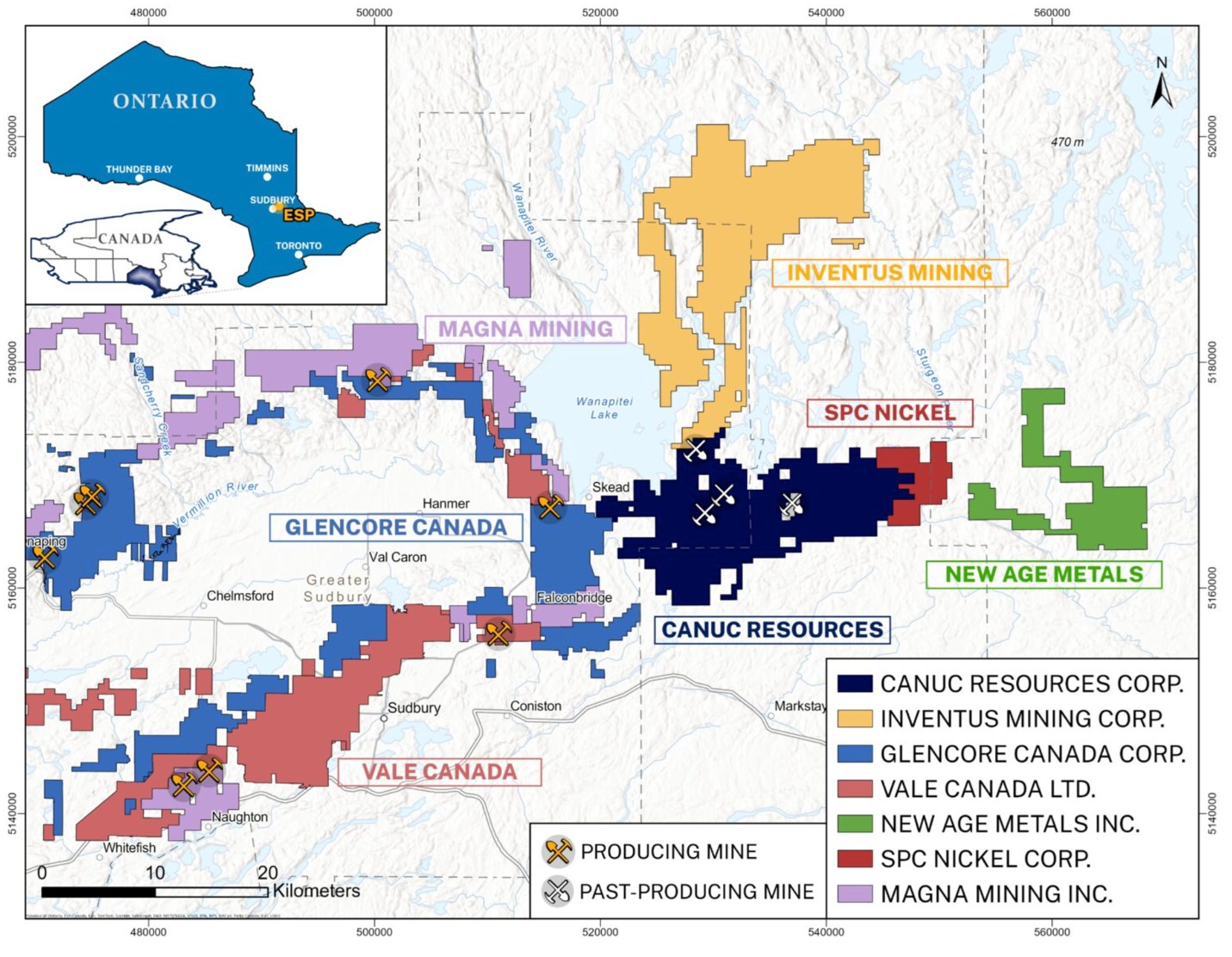
Canuc Resources Corporation (TSX-V: CDA) (OTCQB: CNUCF) (WKN: A41V6H) is pleased to provide an exploration update for the Company’s East Sudbury Project. ESP spans 20,078 hectares and is centered approximately 20 kilometers northeast of the Prolific Sudbury Mining District. (Figure 1 – Regional Location map)

Figure 1 – Project Location Map
To view an enhanced version of this graphic, please visit:
https://images.newsfilecorp.com/files/2906/302782_5850a2c4745b0b28_001full.jpg
ESP encompasses four subparallel fault structures which host historical gold and copper mines, and which are interpreted to be related to mineral systems that can form IOCG and affiliated critical and precious mineral deposits. Mineral prospective zones adjacent to these fault structures are labelled: Timmins Creek Fault Zone, McLaren Lake Fault Zone, Mount Aetna Fault Zone and Washigami Lake Fault Zone respectively (Figure 2 – ESP Fault Structures Map).
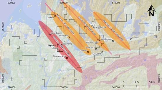
Figure 2 – ESP Fault Structures MAP
To view an enhanced version of this graphic, please visit:
https://images.newsfilecorp.com/files/2906/302782_5850a2c4745b0b28_002full.jpg
Timmins Creek Fault Zone
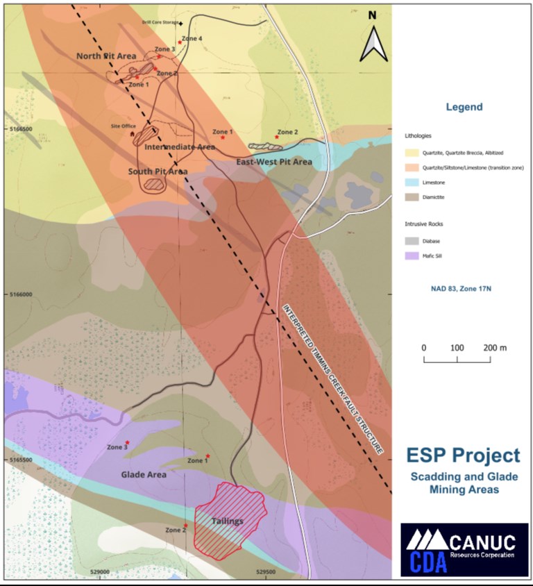
On the ESP property’s furthest west fault structure, Timmins Creek Fault Zone, are found the historical mine working of the Scadding Gold Mines (North Pit, Underground Portal, East-West Pit and South Pit). The Glade Area ‘Exploration’ Zones and the Scadding Mine Gold Tailings Impound are located approximately 1 km southwest and south of the historical Scadding Gold Mines (Figure 3 – Scadding Gold Mines and Glade Area Map).
Other Au-Co-Cu occurrences occur along this interpreted structure (Timmins Creek Fault) including a strong breccia zone and highly anomalous Co-Au mineralization identified by Canuc in 2025 at Spar Lake, 3 km northwest of Scadding.
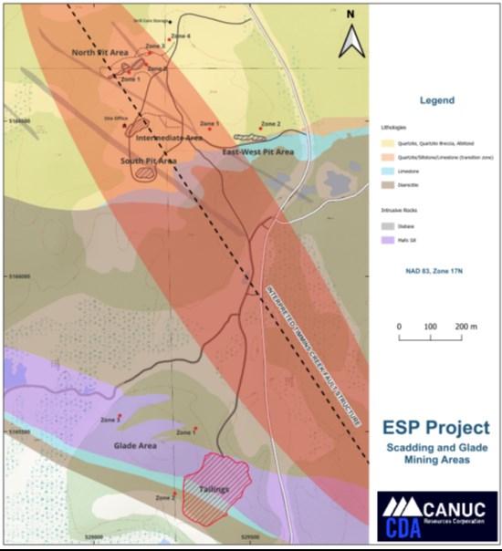
Figure 3 – Scadding Gold Mines and Glade Area Map
To view an enhanced version of this graphic, please visit:
https://images.newsfilecorp.com/files/2906/302782_5850a2c4745b0b28_003full.jpg
Glade Area Zones (1-3) and Historical Scadding Gold Mines
Canuc has undertaken initial drill testing on the Glade Area, a target that consists of three distinct zones of gold and critical minerals (Cu-Co-Ni-PGM’s). The Glade Area is located approximately 1 km south of the historical Scadding Gold Mines.
Ongoing exploration near to the historical Scadding Gold Mine workings is also in progress. Exploration proximal to the historical Scadding Gold Mines is currently focused on two target areas, North Pit (gold zones reported on earlier in news releases dated December 1, 2025 and March 18, 2026) and the East-West Pit, an Au-Cu-Co exploration target adjacent to a previously mined open pit east of the main Scadding Mine (Figure 3 above).
The Glade Area and the historical Scadding Gold Mines are found within the Timmins Creek Fault Zone which is the ESP property’s furthest west of four regional fault structures (Figure 2 above).
Glade Area Historical Workings
Drilling in the Glade Area was focused on 2 of 3 target zones that were discovered in the 1930’s by Wanapitei Basin Mines Limited. Between 1933 and 1945 this company completed trenching, pitting and at least 20 drill holes (2,520 m). As reported in an assessment report prepared for the Ontario Department of mines (1972; Glade Explorations Limited (41I10NE0202), the work outlined three mineralized zones reported to contain 42,000 tons @ 0.36 oz/ton (38,100 tonnes @ 12.34 g/t). The reliability and relevance of this estimate is unknown. There is no information such as cutoff grade or density relating to the parameters used in calculating this estimate other than that it is restricted to above the depth of 200 feet and the dimensions of the zones were tabulated. The categories used (tonnage and grade) are not compliant, nor can they be validly compared, with any categories defined by current CIM Definition Standards. There are no more recent Mineral Resource Estimates.
The mineral occurrences have been re-located on the property and are currently being evaluated by stripping and diamond drilling. A comprehensive drilling program at a minimum of 25-meter spaced holes will be required to define mineralized zones in these areas.
Current Drilling and Exploration Work at Glade Area
Table 1- Glade Area Drill Hole Collar Information
| Drill Hole | NAD 83 Zone 17N | Elevation (m) |
Azimuth (ᵒ) |
Dip (ᵒ) |
Depth (m) |
|
| Easting | Northing | |||||
| SM-26-142 | 529279 | 5165545 | 309.8 | 135 | -45 | 144.0 |
| SM-26-143 | 529277 | 5165543 | 309.8 | 139 | -65 | 105.0 |
| SM-26-144 | 529273 | 5165532 | 310.7 | 150 | -45 | 88.8 |
| SM-26-145 | 529272 | 5165532 | 310.7 | 153 | -65 | 90.0 |
| SM-26-146 | 529298 | 5165331 | 317.0 | 348 | -45 | 168.0 |
| SM-26-147 | 529298 | 5165330 | 317.0 | 348 | -65 | 135.0 |
| SM-26-148 | 529298 | 5165331 | 317.0 | 348 | -45 | 168.0 |
Glade Area Zone 1
Four shallow, close spaced holes tested Glade Zone 1 (formerly referred to as the Glade East occurrence). Mineralization in this zone is associated with quartz-carbonate veining within a sheared Nipissing Mafic sill. All the holes intersected zones of elevated gold values. Two holes intersected the targeted Glade Zone 1 structure in its projected location including hole AG-26-144 which intersected 11.4 g/t over an 0.8 m interval. The intersected values are shown in Table 2 – Glade Area Zone 1 Drill Results.
Table 2 – Glade Area Zone 1 Drill Results
| Drill Hole | Zone | From (m) |
To (m) |
Intersected Width (m) |
Au (g/t) |
| SM-26-142 | Glade 1.1 | 44.5 | 61.5 | 17.0 | 0.703 |
| (Incl) | 50.0 | 51.0 | 1.0 | 4.23 | |
| Glade 1.2 | 99.6 | 100.6 | 1.0 | 10.30 | |
| SM-26-143 | weakly elevated gold | ||||
| SM-26-144 | Glade 1.1 | 27.3 | 36.0 | 8.7 | 0.28 |
| (Incl) | 1.0 | 1.14 | |||
| Glade 1.2 | 65.7 | 66.5 | 0.8 | 11.40 | |
| SM-26-145 | weakly elevated gold | ||||
Glade Area Zone 2
Hole AG-26-146 was drilled to test a second target now referred to as Glade Zone 2 (formerly referred to as Glade South). Glade Area Zone 2 is a highly deformed contact zone between a Nipissing Mafic sill and underlying Espanola Limestone. The contact is exposed in a stripped area completed by former explorers in 2021. Gold mineralization is reported in this area hosted by quartz-carbonate veins and within a limestone unit. Chalcopyrite (Cu) mineralization has also been observed in outcrop of the lower member of an adjacent Nipissing Mafic sill along a distance of approximately 100 meters.
Hole AG-26-146 intersected both the Au-bearing vein (Glade Zone 2.1) and the mafic sill hosted Cu zone (Glade Zone 2.2). The vein intersection assayed 1.79 g/t Au over a 7.9 m interval including 1.0 m of 6.18 g/t Au. A 23.0-meter interval (10 to 12 m wide true thickness) of brecciated and chloritized gabbroic rock was intersected. The interval contained scattered patches and layers of sulphides (chalcopyrite-pyrrhotite) including a 1.4 m wide interval of approximately 10% sulphides. The sulphides in this zone are associated with an iron-rich chlorite breccia. Both zones are similar in appearance to the mineralized zones in chloritized quartzite breccia at the Scadding Gold Mine.
The 23 m wide intersection assayed 0.09 Cu, including 1.4 m of 0.73% Cu, and highly elevated Au, Ni and Co. as shown in Table 2. Palladium values were also anomalous in this zone, ranging from 24 to 241 ppb in a background of <5 ppb.
Hole AG-26-148 was drilled from the same pad as AG-26-146 but oriented at right angles to the mafic intrusive/limestone contact in this area. The hole intersected a 9.2 m wide interval assaying 8.99 g/t Au. The true orientation and thickness of this vein is not known but it appears to align with the quartz-carbonate vein intersection in hole AG-26-146 (Glade Zone 2.1). Additional drilling is required to determine the significance of this intersection. The intersected values are shown in Table 3 – Glade Area Zone 2 Drill Results.
Table 3 – Glade Area Zone 2 Drill Results
| Drill Hole | Zone | From (m) |
To (m) |
Intersected Width (m) | Au (g/t) |
Cu (%) |
Ni (%) |
Co (%) |
| SM-26-146 | Glade 2.1 | 56.6 | 64.5 | 7.9 | 1.79 | 0.03 | 0.04 | 0.02 |
| (Incl) | 60.6 | 61.6 | 1.0 | 6.18 | 0.02 | 0.08 | 0.04 | |
| Glade 2.2 | 97.0 | 120.0 | 23.0 | 0.09 | 0.08 | 0.04 | 0.05 | |
| (Incl) | 107.7 | 118.2 | 10.5 | 0.11 | 0.16 | 0.07 | 0.06 | |
| (Incl) | 107.7 | 109.1 | 1.4 | 0.60 | 0.73 | 0.31 | 0.01 | |
| SM-26-147 | drilled down dip – terminated in sediments | |||||||
| SM-26-148 | Glade 2.1 | 20.1 | 29.3 | 9.2 | 8.99 | 0.02 | tr | tr |
| (Incl) | 23.1 | 26.2 | 3.1 | 24.85 | 0.02 | tr | tr | |
| (Incl) | 25.3 | 26.2 | 0.9 | 60.10 | 0.02 | tr | tr | |
The mineralization intersected in both zones at Glade Zone 2 is contained within a distinct chlorite-matrix breccia with associated sulphides – including iron (as Py, Po), copper, nickel and cobalt as well as scattered disseminated iron oxides (magnetite). This same suite of minerals is also found at the Scadding Gold Mine approximately 1 km to the north. Geological mapping suggests that both the Glade and Scadding deposits may be associated with a previously unrecognized fault structure that is parallel to the McLaren Lake Fault Zone located 3 km to the east. Figure 2 shows the projected axis of this fault zone referred to as the Timmins Creek Fault Zone along with several other interpreted parallel structures. Several of the many historical prospects located within the boundary of Canuc’s ESP Project are shown on Figure 2.
Two additional holes have been drilled in the Glade Area, but assay results have not yet been received.
“These results show evidence of a polymetallic metal suite proximal to, or in association with, elevated gold detection at the company’s Glade Area exploration targets which are located 1 km south of the past producing Scadding Gold Mines along the regional Timmins Creek Fault Zone structure. This outcome is consistent with the MIAC and IOCG deposit models which we are pursuing at ESP,” stated Chris Berlet, President and CEO of Canuc.
“We will now use these results, in conjunction with the upcoming gravity and magnetic surveys, to vector further drilling in pursuit of a transformative regional exploration outcome at ESP.”
The technical information in this release has been reviewed and approved by Seymour Sears, B.A., B.Sc., P.Geo, a non-independent qualified person as defined by NI 43-101, who is currently managing exploration activity on the ESP Project.
About Canuc Resources Corporation
Canuc Resources Corporation is a junior resource company developing its 100% interest in the East Sudbury Project which spans 20,078 hectares and is centered approximately 20 kilometers northeast of the Prolific Sudbury Mining Camp and near to the extensive infrastructure of the adjacent Sudbury Mining District. ESP encompasses several centers of critical and precious metal mineralization interpreted to be related to a mineral system that can form IOCG and affiliated critical and precious mineral deposits. Included within the Project is the historical Scadding Gold Mine and associated Scadding Gold Tailings Project.
Canuc also holds a 100% interest in the San Javier Silver-Gold Project located in Sonora State, Mexico. The San Javier Silver-Gold Project spans 28 claims covering 1,052 hectares and evidences extensive silver, gold and copper mineralization interpreted to be related to a mineral system that can form silver-dominant IOCG and affiliated deposits.
Canuc generates cash flow from natural gas production at its MidTex Energy Project located in Central West Texas, USA where Canuc has an interest in eight (8) producing natural gas wells and has rights for further in field developments. The Company also receives a 4% Net Smelter Royalty from gold production at the Scadding Gold Tailings Project located on Mining Claim LEA 107735 within the ESP property group.
For further information please refer to the Company website: www.canucresources.ca
Christopher J. Berlet B.A.Sc.(Mining), CFA, CEO & Director of Canuc, is responsible for the content of this press release.
For further information please contact:
Canuc Resources Corporation
(416) 525 – 6869
cberlet@canucresources.ca
Imperial Metals Corporation (TSX:III) reports copper and gold p... READ MORE
Aldebaran Resources Inc. (TSX-V: ALDE) (OTCQX: ADBRF) and its maj... READ MORE
Nevada Sunrise Metals Corporation (TSX-V: NEV) (OTC Pink: NVSGF)... READ MORE
Newmont Corporation (NYSE: NEM) (ASX: NEM) (PNGX: NEM) announced ... READ MORE
Scorpio Gold Corporation (TSX-V: SGN) (OTCQB: SRCRF) (FSE: RY9) i... READ MORE


