


![]()
The Eastern Expansion Drill Program Is Targeting Prospective Shallow Mineralization Encountered in Scout Drilling Across a 1.2 Kilometre Trend
EASTERN EXPANSION PROGRAM HIGHLIGHTS:
Blackrock Silver Corp. (TSX-V: BRC) (OTCQX: BKRRF) (FSE: AHZ0) announces partial assay results from its fully-funded eastern expansion drill program at its 100% owned Tonopah West project located in Nye and Esmeralda Counties, Nevada, United States.
The Eastern Expansion Program was a follow-up to the Company’s scout drill program at Tonopah West completed in February 2025 (see March 31, 2025 news release), which showed significant potential to expand the DPB South resource area 1,200 metres in an easterly direction.
The Eastern Expansion Program commenced in July 2025 within the Eastern Expansion Zone, utilizing reverse circulation drilling to establish initial holes, which were then deepened using diamond core drilling (core tails) for more detailed geological analysis. The Program drilled a total of 6,798 metres (22,896 feet) in twenty-four drillholes, however, only 22 drillholes were completed, as two pre-collar holes were not usable for core tails. Of the 22 completed drillholes, three were core holes completed from surface.
Andrew Pollard, Blackrock’s President and Chief Executive Officer, stated: “Initial assays from our Eastern Expansion Program have returned both high-grades and broad zones of shallow silver and gold intercepts potentially extending up to 1,200 metres along trend from the DPB South Resource shell. At the historic Ohio mine area on the eastern margin of Tonopah West, hole TXC25-166 intersected 5.03 metres grading 750 g/t AgEq, offsetting the mineralized structure first identified in RC hole TW25-128, which returned two 1.52 metres zones grading 1,198 g/t Ag and 9.61 g/t Au starting at 292.6 metres and 219 g/t Ag and 1.72 g/t Au starting at 297.2 metres earlier this year. Thick zones of mineralization, spanning between 5.67 to 8.75 metres were encountered in drillholes TXC25-164 and TXC25-159 just east of the existing DPB South resource area, situated in close proximity to our planned exploration decline. As our geologic model continues to advance along the outer ring of the fraction caldera, and with assays pending from an additional 13 drillholes under the Program, this emerging zone represents significant tonnage potential that can meaningfully expand the Tonopah West mineral resource base stemming from the edge of DPB South zone through to the eastern boundary of Tonopah West.”
Table 1 summarizes the results of the Eastern Expansion Program using a cut-off grade of 150 g/t AgEq.
Table 1: Eastern Expansion Program Significant Results
| Drillhole ID | Program | Area | Hole Type | From (m) | To (m) | Drillhole Interval (m) | Ag g/t | Au g/t | AgEq g/t |
| TXC25-158 | E Expansion | DPB South | RC/Core | 146.30 | 147.83 | 1.52 | 123.0 | 0.852 | 216.0 |
| TXC25-158 | E Expansion | DPB South | RC/Core | 272.83 | 273.86 | 1.04 | 17.9 | 2.353 | 274.8 |
| Including | 273.56 | 273.86 | 0.30 | 59.8 | 7.970 | 930.1 | |||
| TXC25-159 | E Expansion | DPB South | RC/Core | 234.18 | 242.93 | 8.75 | 90.3 | 0.943 | 193.3 |
| Including | 241.65 | 242.47 | 0.82 | 567.7 | 5.953 | 1217.8 | |||
| TXC25-160 | E Expansion | DPB South | RC/Core | 146.30 | 147.83 | 1.52 | 79.4 | 6.660 | 806.6 |
| TXC25-164 | E Expansion | DPB South | RC/Core | 180.44 | 186.11 | 5.67 | 3.6 | 2.379 | 263.4 |
| Including | 185.01 | 186.11 | 1.10 | 9.2 | 8.670 | 955.9 | |||
| TXC25-166 | E Expansion | Ohio | RC/Core | 160.17 | 160.78 | 0.61 | 114.9 | 1.658 | 296.0 |
| TXC25-166 | E Expansion | Ohio | RC/Core | 165.20 | 170.23 | 5.03 | 306.8 | 4.062 | 750.3 |
| Including | 166.73 | 168.56 | 1.83 | 724.1 | 8.577 | 1660.6 | |||
| AgEq = Ag + Au/(Factor); where Factor = (Ag Price/Au Price)*(Ag Recovery/Au Recovery) or Factor=($27/$2,700)*(87%/95%)=0.009157; True thickness is 75% to 85% of drill interval; NSV=No values above cut off; Cut-off grade is 150 g/t AgEq; RC/Core = RC pre-collar with core tail; Core is core from the surface. | |||||||||
Thick intervals were noted in TXC25-159, -164 and -166 which ranged between 5.03 to 8.75 metres. True thickness is estimated to be between 75% and 85% of the drilled interval. The thick mineralized intervals speaks to the potential of the Eastern Expansion Zone.
TXC25-166 and TW25-128 (Scout Program) cut thick, and high-grade intervals along the Pittsburg-Monarch fault system which is oriented north-northwest. This splay of the fault opens additional upside along the eastern margin of the property from TW25-128, which returned 1.52 metres grading 1,198 g/t Ag and 9.61 g/t Au (see March 31, 2025 news) towards TW20-001, which cut 28.96 metres of 435.7 g/t Ag and 5.29 g/t Au, representing a horizontal distance of approximately 1,100 metres.
Drillholes TXC25-157, -161 and -163 were mineralized with TXC25-161 returning 2.4 g/t Ag and 0.92 g/t Au over 1.98 metres, and TXC25-163 yielding 31.7 g/t Ag and 0.78 g/t Au over 0.95 metres. TXC25-157 encountered 0.46 metres grading 60.2 g/t Ag and 0.74 g/t Au. TXC25-156, -162, and -165 did not return significant results.
Assay results for eleven Eastern Expansion holes (TXC25-167 through -170 and TXC25-172 through -177 and TXC25-179 are pending at this time. TXC25-171 and TXC25-178 were completed in the DPB South resource area, and assays are pending for these two holes at this time.
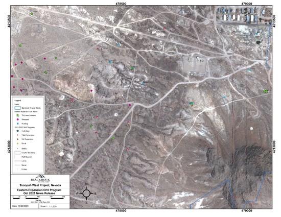
Figure 1: Drillhole location map for the Eastern Expansion drillholes reported in this news release
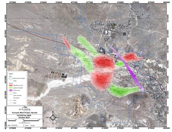
Figure 2: Tonopah West expansion potential
| Drillhole ID | Area | Program | Type | UTM_NAD27 E | UTM_NAD27 N | Elevation (m) | Depth (ft) | Depth (m) | Azimuth | Dip |
| TXC25-156 | Ohio | E Expansion | RC/Core | 479073.0 | 4213222.0 | 1843.4 | 1000.0 | 304.8 | 150 | -60 |
| TXC25-157 | DPB South | E Expansion | RC/Core | 478100.0 | 4213400.0 | 1785.0 | 888.0 | 270.7 | 180 | -60 |
| TXC25-158 | DPB South | E Expansion | RC/Core | 478150.0 | 4213530.0 | 1786.0 | 1165.0 | 355.1 | 180 | -60 |
| TXC25-159 | DPB South | E Expansion | RC/Core | 478200.0 | 4213300.0 | 1789.0 | 878.0 | 267.6 | 180 | -55 |
| TXC25-160 | DPB South | E Expansion | RC/Core | 478540.0 | 4213310.0 | 1800.0 | 953.0 | 290.5 | 180 | -65 |
| TXC25-161 | DPB South | E Expansion | RC/Core | 478240.0 | 4213360.0 | 1793.0 | 1050.0 | 320.0 | 180 | -65 |
| TXC25-162 | Ohio | E Expansion | RC/Core | 479073.0 | 4213222.0 | 1843.4 | 922.0 | 281.0 | 180 | -60 |
| TXC25-163 | DPB South | E Expansion | RC/Core | 478450.0 | 4213040.0 | 1805.0 | 932.0 | 284.1 | 0 | -65 |
| TXC25-164 | DPB South | E Expansion | RC/Core | 478375.0 | 4213088.0 | 1800.0 | 1042.0 | 317.6 | 0 | -60 |
| TXC25-165 | Ohio | E Expansion | RC/Core | 478778.0 | 4213176.0 | 1824.5 | 1130.0 | 344.4 | 120 | -50 |
| TXC25-166 | Ohio | E Expansion | RC/Core | 479073.0 | 4213222.0 | 1843.4 | 1230.0 | 374.9 | 40 | -75 |
Quality Assurance/ Quality Control
All sampling is conducted under the supervision of the Company’s project geologists, and a strict chain of custody from the project to the sample preparation facility is implemented and monitored. The RC samples are hauled from the project site to a secure and fenced facility in Tonopah, Nevada, where they are loaded on to American Assay Laboratory’s (AAL) flat-bed truck and delivered to AAL’s facility in Sparks, Nevada. A sample submittal sheet is delivered to AAL personnel who organize and process the sample intervals pursuant to the Company’s instructions.
The RC samples are lined out at the lab and logged into AAL’s system. The samples are dried, crushed to 85% passing 10 mesh (2mm) and a 250-gram sub-sample split is collected and pulverized to 200 mesh (74 micron) in a ring and puck pulverizer. Then the pulverized material is digested and analyzed for gold using fire assay fusion and an Induced Coupled Plasma (ICP) finish on a 30-gram assay split (FA-PB30-ICP). Silver is determined using five-acid digestion and ICP analysis (ICP-5AM48). Over limits for gold and silver are determined using a gravimetric finish (GRAVAU30 and GRAVAG30). Data verification of the assay and analytical results are completed to ensure accurate and verifiable results. Blackrock personnel insert a blind prep blank, lab blank or a certified reference material approximately every 15th to 20th sample.
Qualified Persons
Blackrock’s exploration activities at Tonopah West are conducted and supervised by Mr. William Howald, Executive Chairman of Blackrock. Mr. William Howald, AIPG Certified Professional Geologist #11041, is a Qualified Person as defined under National Instrument 43-101 – Standards of Disclosure for Mineral Projects. He has reviewed and approved the contents of this news release.
About Blackrock Silver Corp.
Backed by gold and silver ounces in the ground, Blackrock is a junior precious metal focused exploration and development company driven to add shareholder value. Anchored by a seasoned Board of Directors, the Company is focused on its 100% controlled Nevada portfolio of properties consisting of low-sulphidation, epithermal gold and silver mineralization located along the established Northern Nevada Rift in north-central Nevada and the Walker Lane trend in western Nevada.
Falco Resources Ltd. (TSX-V:FPC) is pleased to announce the resul... READ MORE
TDG Gold Corp. (TSX-V: TDG) (OTCQX: TDGGF) is pleased to provide ... READ MORE
Extension drilling extended mineralization beyond the current pit... READ MORE
Abcourt Mines Inc. (TSX-V: ABI) (OTCQB: ABMBF) continues its work... READ MORE
Premier American Uranium Inc. (TSX-V: PUR) (OTCQB: PAUIF) is plea... READ MORE


