


![]()
Multiple Drillholes Confirm High-Grade Silver and Gold over Significant Widths Along a 500 Metre Trend in Final Assays from Resource Expansion Program
HIGHLIGHTS:
Blackrock Silver Corp. (TSX-V: BRC) (OTCQX: BKRRF) (FSE: AHZ0) announces the final set of assay results from its Resource Expansion Program (defined below) showing significant width and high-grade silver and gold drill intercepts in step-out drilling at its 100% owned Tonopah West project located in Nye and Esmeralda Counties, Nevada, United States.
Blackrock’s resource expansion program at Tonopah West which commenced in September 2024, consisted of 18 drillholes totalling 10,802 metres (35,438 feet) of drilling, targeted expansion potential along a one-kilometre northwest trend between the Denver-Paymaster and Bermuda-Merten vein groups south resource area and the Northwest Step Out resource area.
The aim of the Resource Expansion Program is to increase the size of the Tonopah West resource footprint and to allow evaluation and inclusion of the NW Step Out resource in an updated preliminary economic assessment to be completed on Tonopah West. This final batch of assay results from the Resource Expansion Program tracked high-grade gold and silver mineralization across significant widths spanning 500 metres from the existing DPB resource area to the northwest.
Andrew Pollard, the Company’s President and Chief Executive Officer, stated: “Final assays from our Resource Expansion Program have confirmed thick, high-grade silver and gold mineralization extending 500 metres beyond the current DPB resource, with standout intercepts including 10.1 metres grading 467 g/t AgEq and 11.6 metres of 327 g/t AgEq. These results reinforce the scale and continuity of the NW vein system and underscore the strong potential to materially expand the resource and extend mine life at Tonopah West. With our geologic model in hand, drill targeting is now underway for the remaining 500-metre gap of vein corridor that aims to fully bridge mineralization to our NW Step Out deposit.”
Table 1:Significant Assays from the Resource Expansion Program Above 150 g/t AgEq Cut-Off
| Drillhole ID | Hole Type | Program | From (m) |
To (m) | Drill Interval (m) |
Ag (g/t) | Au (g/t) | AgEq (g/t) |
| TXC25-144 | RC/Core | Resource Expansion | 393.04 | 403.16 | 10.12 | 283.2 | 2.040 | 467.2 |
| Including | 395.78 | 399.29 | 3.51 | 620.2 | 4.426 | 1,019.5 | ||
| TXC25-145 | RC/Core | Resource Expansion | 351.13 | 353.45 | 2.32 | 241.8 | 1.760 | 400.6 |
| TXC25-145 | RC/Core | Resource Expansion | 361.37 | 372.95 | 11.58 | 186.1 | 1.559 | 326.7 |
| Including | 361.37 | 362.04 | 0.67 | 2,007.6 | 13.928 | 3,264.1 | ||
| TXC25-145 | RC/Core | Resource Expansion | 379.17 | 380.03 | 0.85 | 166.6 | 1.491 | 301.2 |
| TXC25-152 | RC/Core | Resource Expansion | 454.06 | 454.58 | 0.52 | 45.9 | 0.611 | 101.0 |
| TXC25-153 | RC/Core | Resource Expansion | 439.37 | 445.10 | 5.73 | 95.8 | 0.672 | 156.4 |
| Including | 444.40 | 445.10 | 0.70 | 437.0 | 3.180 | 723.9 | ||
| TXC25-155 | RC/Core | Resource Expansion | 413.86 | 414.83 | 0.98 | 109.7 | 0.982 | 198.3 |
| AgEq = Ag + Au*(Factor); where Factor = (Au Price/Ag Price)*(Au Recovery/Ag Recovery or Factor=($1,900/$23)*(95%/87%)=90.21; True thickness is 50% to 70% of drill interval; Cut-off grade is 150 g/t AgEq; Reverse Circulation (RC)/Core = RC pre-collar with core tail; Core is core from the surface. | ||||||||
Table 2: Significant Assays From the entire Resource Expansion Program Above 150 g/t AgEq Cut Off highlighting the grade and thickness of the zone over 500 metres
| Drillhole ID | Hole Type | Program | From (m) |
To (m) | Drill Interval (m) |
Ag (g/t) | Au (g/t) | AgEq (g/t) |
| TXC24-113 | RC/Core | Resource Expansion | 478.08 | 478.39 | 0.31 | 614.0 | 7.140 | 1,256.7 |
| TXC24-113 | RC/Core | Resource Expansion | 503.13 | 504.66 | 1.52 | 116.8 | 0.904 | 198.2 |
| TXC24-113 | RC/Core | Resource Expansion | 538.43 | 540.11 | 1.68 | 364.0 | 0.033 | 367.0 |
| TXC24-114 | RC/Core | Resource Expansion | 394.08 | 395.63 | 1.55 | 93.9 | 1.553 | 233.7 |
| Including | 394.08 | 394.41 | 0.34 | 288.0 | 5.270 | 762.4 | ||
| TXC25-123 | RC/Core | Resource Expansion | 436.87 | 437.54 | 0.67 | 182.0 | 1.690 | 334.1 |
| TXC25-123 | RC/Core | Resource Expansion | 471.83 | 474.88 | 3.05 | 225.4 | 2.412 | 442.5 |
| Including | 471.83 | 472.14 | 0.31 | 2,223.0 | 23.467 | 4,335.3 | ||
| TXC25-124 | RC/Core | Resource Expansion | 370.03 | 378.62 | 8.60 | 121.6 | 1.233 | 232.6 |
| Including | 371.55 | 372.31 | 0.76 | 778.6 | 7.854 | 1,485.6 | ||
| TXC25-124 | RC/Core | Resource Expansion | 407.40 | 410.26 | 2.87 | 176.8 | 1.785 | 337.5 |
| Including | 407.40 | 407.76 | 0.37 | 1,344.0 | 13.500 | 2,559.2 | ||
| TXC25-144 | RC/Core | Resource Expansion | 393.04 | 403.16 | 10.12 | 283.2 | 2.040 | 467.2 |
| Including | 395.78 | 399.29 | 3.51 | 620.2 | 4.426 | 1,019.5 | ||
| TXC25-145 | RC/Core | Resource Expansion | 351.13 | 353.45 | 2.32 | 241.8 | 1.760 | 400.6 |
| TXC25-145 | RC/Core | Resource Expansion | 361.37 | 372.95 | 11.58 | 186.1 | 1.559 | 326.7 |
| Including | 361.37 | 362.04 | 0.67 | 2,007.6 | 13.928 | 3,264.1 | ||
| TXC25-145 | RC/Core | Resource Expansion | 379.17 | 380.03 | 0.85 | 166.6 | 1.491 | 301.2 |
| TXC25-152 | RC/Core | Resource Expansion | 454.06 | 454.58 | 0.52 | 45.9 | 0.611 | 101.0 |
| TXC25-153 | RC/Core | Resource Expansion | 439.37 | 445.10 | 5.73 | 95.8 | 0.672 | 156.4 |
| Including | 444.40 | 445.10 | 0.70 | 437.0 | 3.180 | 723.9 | ||
| TXC25-155 | RC/Core | Resource Expansion | 413.86 | 414.83 | 0.98 | 109.7 | 0.982 | 198.3 |
| AgEq = Ag + Au*(Factor); where Factor = (Au Price/Ag Price)*(Au Recovery/Ag Recovery or Factor=($1,900/$23)*(95%/87%)=90.21; True thickness is 50% to 70% of drill interval; Cut-off grade is 150 g/t AgEq; RC/Core = RC pre-collar with core tail; Core is core from the surface. | ||||||||
The NW vein system is located along contacts between lithologic units and forms a wide anastomosing and intersecting network of veins and breccias within the West End Rhyolite package. The veins dip approximately 55 degrees to the northeast and show excellent continuity over approximately 500 metres of strike.
TXC25-124, -144, and TXC25-145 have especially wide zones above the 150 g/t AgEq cut off. TXC25-154 returned an exceptionally wide zone of low-grade over 17.1 metres with 0.154 g/t Au and 25.8 g/t Ag. These drillhole intercepts show the system has strength and ability to mineralize a large volume of rock.
The position, orientation and character of the NW vein system is consistent with the outer ring structure of the Fraction caldera marked farther south by the Merten vein. The mineralization is open to the northwest and down dip to the northeast giving ample room for additional resource expansion of the Tonopah West silver and gold system.
Geologic cross sections are being constructed to better understand the silver and gold system to the northwest. Targeting is now underway to bridge mineralization on remaining 500 metres of vein corridor to NW Step Out resource area.
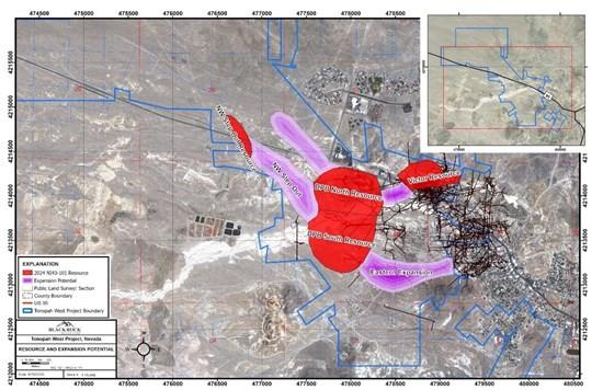
Figure 1: Tonopah West showing NI 43-101 resource location and expansion potential
Figure 2 is a plan map showing the location of all the drillholes in the Resource Expansion Program and highlighting those drillholes reported in this news release.
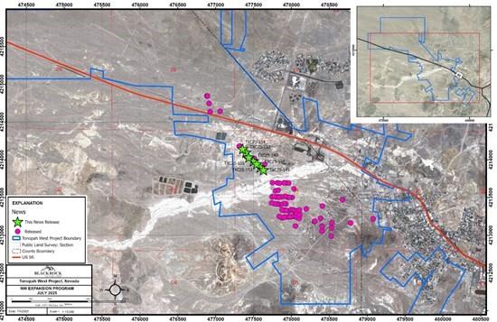
Figure 2: Drillhole location map of the Resource Expansion Program showing drillholes reported in this news release.
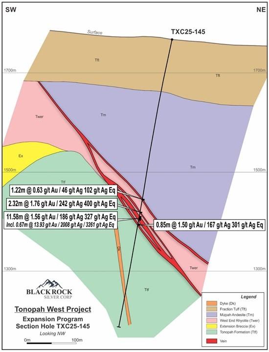
Figure 3: Northeast-southwest oriented cross section along TXC25-145, looking northwest, showing the anastomosing vein character of the intercepts
Table 3: Tonopah West Drillhole Location Coordinates (based on GPS readings in the field, Datum UTM, NAD 1927, Zone 11)
| Drillhole ID | Area | Program | Type | UTM_NAD27 E |
UTM_NAD27 N |
Elevation (m) |
Depth (ft) |
Depth (m) |
Azimuth | Dip |
| TXC24-106 | NW Step Out | Resource Expansion | RC/Core | 476887.1 | 4214846.1 | 1746.6 | 2528.0 | 770.5 | 270 | -80 |
| TXC24-107 | NW Step Out | Resource Expansion | Lost | 476889.2 | 4214843.0 | 1746.9 | 387.0 | 118.0 | 230 | -65 |
| TXC24-108 | NW Step Out | Resource Expansion | Core | 476891.5 | 4214844.8 | 1747.3 | 2340.5 | 713.4 | 230 | -65 |
| TXC24-109 | NW Step Out | Resource Expansion | RC/Core | 476911.1 | 4214747.8 | 1748.0 | 2157.0 | 657.5 | 270 | -80 |
| TXC24-110 | NW Step Out | Resource Expansion | RC/Core | 476925.9 | 4214639.9 | 1744.1 | 2157.0 | 657.5 | 270 | -80 |
| TXC24-111 | NW Step Out | Resource Expansion | RC/Core | 477058.8 | 4214642.7 | 1747.6 | 2325.0 | 708.7 | 230 | -65 |
| TXC24-112 | NW Step Out | Resource Expansion | RC/Core | 477316.7 | 4214181.8 | 1751.9 | 2418.0 | 737.0 | 290 | -65 |
| TXC24-113 | NW Step Out | Resource Expansion | RC/Core | 477311.2 | 4214181.0 | 1751.7 | 1772.0 | 540.1 | 220 | -75 |
| TXC24-114 | NW Step Out | Resource Expansion | RC/Core | 477403.8 | 4214041.9 | 1757.9 | 2028.0 | 618.1 | 220 | -75 |
| TXC25-123 | NW Step Out | Resource Expansion | RC/Core | 477508.7 | 4214018.0 | 1767.1 | 1648.0 | 502.3 | 180 | -65 |
| TXC25-124 | NW Step Out | Resource Expansion | RC/Core | 477647.0 | 4213941.2 | 1763.5 | 1724.0 | 525.5 | 180 | -60 |
| TXC25-143 | NW Step Out | Resource Expansion | RC/Core | 477497.8 | 4213983.1 | 1766.9 | 1938.0 | 590.7 | 220 | -78 |
| TXC25-144 | NW Step Out | Resource Expansion | RC/Core | 477587.9 | 4213900.1 | 1766.1 | 2047.0 | 623.9 | 220 | -78 |
| TXC25-145 | NW Step Out | Resource Expansion | RC/Core | 477630.4 | 4213865.9 | 1764.5 | 1927.0 | 587.3 | 220 | -77 |
| TXC25-152 | NW Step Out | Resource Expansion | RC/Core | 477397.8 | 4214095.5 | 1755.0 | 2011.0 | 613.0 | 220 | -77 |
| TXC25-153 | NW Step Out | Resource Expansion | RC/Core | 477541.2 | 4213943.8 | 1763.7 | 1927.0 | 587.3 | 220 | -78 |
| TXC25-154 | NW Step Out | Resource Expansion | RC/Core | 477356.1 | 4214144.1 | 1754.0 | 2105.5 | 641.8 | 220 | -77 |
| TXC25-155 | NW Step Out | Resource Expansion | RC/Core | 477435.7 | 4214030.9 | 1758.0 | 1998.0 | 609.0 | 220 | -78 |
Quality Assurance/ Quality Control
All sampling is conducted under the supervision of the Company’s project geologists, and a strict chain of custody from the project to the sample preparation facility is implemented and monitored. The RC and core samples are hauled from the project site to a secure and fenced facility in Tonopah, Nevada, where they are loaded on to American Assay Laboratory’s (AAL) flat-bed truck and delivered to AAL’s facility in Sparks, Nevada. A sample submittal sheet is delivered to AAL personnel who organize and process the sample intervals pursuant to the Company’s instructions.
The RC samples are lined out at the lab and logged in to AAL’s system. The core samples are cut using core saws and personnel at AAL’s facility in Sparks, Nevada according to the Company’s instructions delivered with each core hole.
All samples are dried, crushed to 85% passing 10 mesh (2mm) and a 250-gram sub-sample split is collected and pulverized to 200 mesh (74 micron) in a ring and puck pulverizer. Then the pulverized material is digested and analyzed for gold using fire assay fusion and an Induced Coupled Plasma (ICP) finish on a 30-gram assay split (FA-PB30-ICP). Silver is determined using five-acid digestion and ICP analysis (ICP-5AM48). Over limits for gold and silver are determined using a gravimetric finish (GRAVAU30 and GRAVAG30). Data verification of the assay and analytical results are completed to ensure accurate and verifiable results. Blackrock personnel insert a blind prep blank, lab blank or a certified reference material approximately every 15th to 20th sample.
Qualified Persons
Blackrock’s exploration activities at Tonopah West are conducted and supervised by Mr. William Howald, Executive Chairman of Blackrock. Mr. William Howald, AIPG Certified Professional Geologist #11041, is a Qualified Person as defined under National Instrument 43-101 – Standards of Disclosure for Mineral Projects. He has reviewed and approved the contents of this news release.
About Blackrock Silver Corp.
Backed by gold and silver ounces in the ground, Blackrock is a junior precious metal focused exploration and development company driven to add shareholder value. Anchored by a seasoned Board of Directors, the Company is focused on its 100% controlled Nevada portfolio of properties consisting of low-sulphidation, epithermal gold and silver mineralization located along the established Northern Nevada Rift in north-central Nevada and the Walker Lane trend in western Nevada.
Summit Royalties Ltd. (TSX-V: SUM) (OTCQX: SUMMF) is pleased to r... READ MORE
Silver Elephant Mining Corp. (TSX: ELEF) (OTCQB: SILEF) (FSE: 1P... READ MORE
Winshear Metals Corp. (TSX-V: WINS) (FRA: 9HR0) reports positive ... READ MORE
Barksdale Resources Corp. (TSX-V: BRO) (OTCQB: BRKCF) (FSE: 2NZ) ... READ MORE
Prospector Metals Corp. (TSX-V: PPP) (OTCQB: PMCOF) (FSE: 1ET) ... READ MORE


