


Banyan Gold Corp. (TSX-V: BYN) (OTCQB: BYAGF) is pleased to announce additional drill results with high-grade gold mineralization from the 2025 drill program in the Powerline Deposit at its AurMac Project, Yukon, Canada.
Powerline Highlights from within areas classified as “waste” in the 2025 Resource block model:
Eastern Powerline (previously referred to as Aurex Hill Area) Highlights detailed below, which improve continuity and expand high-grade domains in satellite pit:
“A key objective of the 2025 drill program was to optimize and improve economics for the upcoming Preliminary Economic Assessment (PEA). The drillholes in this release were strategically targeted in areas identified by the 3D model as potential zones where waste blocks could be converted into high-grade ore by extending both new and previously identified mineralized domains,” said Tara Christie, President and CEO. “These results successfully achieve that goal and demonstrate the continuity of high-grade gold mineralization associated with sheeted veins in the core and the eastern portion of Powerline Deposit.”

Figure 1: Plan map of Central Powerline with highlighted drill intervals from this release.
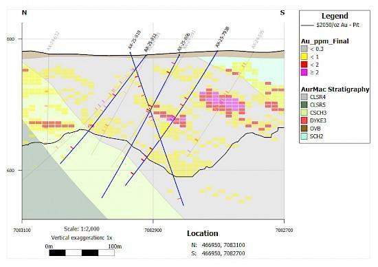
Figure 2: Cross-section 466950mE in Powerline (See Figure 1). High-grade mineralization associated with sheeted veins extends high-grade mineralized domains and has potential to convert near-surface waste blocks into high-grade ore while confirming continuity of the mineralization in Powerline and effective targeting based on the new geologic model.
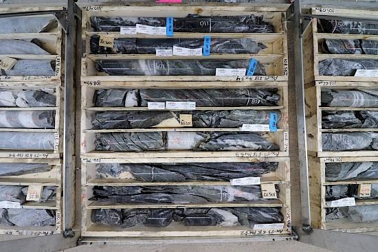
Figure 3: Diamond drill core from AX-25-818. Sheeted veins cutting metasedimentary rocks of the Hyland group, typical of the Powerline deposit hosting trace Bismuth sulphosalts, arsenopyrite and visible gold (See Figure 2).
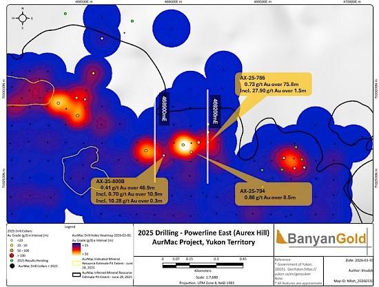
Figure 4: Plan map of highlight gold intersections in Eastern Powerline (Aurex Hill). Cross-sections 468900mE (Figure 5) and 469200mE (Figure 6) highlight potential waste block conversion and high-grade intervals near surface and extending up-dip at depth.
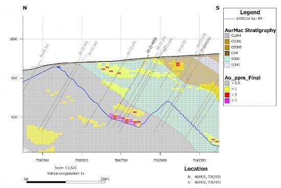
Figure 5: High-grade mineralization near surface in drillhole AX-25-800B has potential to convert additional waste blocks in the Eastern Powerline (Aurex Hill) satellite pit.
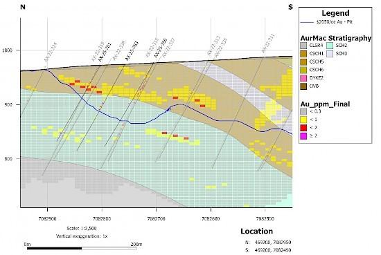
Figure 6: High-grade mineralization in drillholes AX-25-781, -783, and -786 has potential to convert near-surface waste blocks and demonstrate improved continuity in lower domains in the Eastern Powerline (Aurex Hill) satellite pit.
Table 1: Diamond drillhole assay intercepts for Powerline in this release.
| HOLE NUMBER | depth from | depth to | Au Interval (m) | Au Interval (g/t) |
| AX-25-739 | 15.0 | 22.5 | 7.5 | 0.31 |
| and | 47.4 | 51.6 | 4.2 | 0.28 |
| and | 68.7 | 69.7 | 1.0 | 0.48 |
| and | 82.6 | 104.8 | 22.2 | 0.30 |
| including | 99.8 | 104.8 | 5.0 | 0.50 |
| including | 99.8 | 100.0 | 0.2 | 5.25 |
| and | 123.4 | 133.3 | 9.9 | 1.15 |
| including | 123.4 | 124.6 | 1.2 | 2.79 |
| and including | 133.0 | 133.3 | 0.3 | 16.10 |
| and | 150.9 | 169.6 | 18.7 | 0.84 |
| including | 164.6 | 166.1 | 1.5 | 8.76 |
| and | 189.0 | 204.0 | 15.0 | 0.37 |
| including | 203.2 | 203.4 | 0.2 | 2.62 |
| and | 219.6 | 221.1 | 1.5 | 0.39 |
| AX-25-793B | 28.1 | 29.5 | 1.4 | 0.31 |
| and | 58.0 | 101.0 | 43.0 | 0.37 |
| including | 86.0 | 87.5 | 1.5 | 2.05 |
| and including | 98.0 | 99.5 | 1.5 | 2.24 |
| and | 118.0 | 153.0 | 35.0 | 0.53 |
| including | 119.5 | 127.0 | 7.5 | 1.44 |
| and | 179.5 | 202.5 | 23.0 | 0.34 |
| and | 227.0 | 228.5 | 1.5 | 1.06 |
| AX-25-806 | 10.0 | 44.0 | 34.0 | 0.37 |
| including | 15.0 | 16.0 | 1.0 | 5.29 |
| and including | 30.5 | 32.0 | 1.5 | 1.74 |
| and | 86.5 | 118.5 | 32.0 | 0.42 |
| including | 88.5 | 99.5 | 11.0 | 0.98 |
| including | 98.5 | 99.5 | 1.0 | 4.51 |
| and | 136.0 | 142.0 | 6.0 | 0.37 |
| and | 156.5 | 158.0 | 1.5 | 0.76 |
| and | 168.5 | 170.0 | 1.5 | 0.59 |
| and | 180.2 | 181.5 | 1.3 | 0.99 |
| and | 193.0 | 194.0 | 1.0 | 0.32 |
| AX-25-809 | 33.0 | 82.8 | 49.8 | 0.43 |
| including | 33.0 | 52.7 | 19.7 | 0.39 |
| and including | 67.8 | 70.9 | 3.1 | 1.92 |
| and | 143.5 | 158.1 | 14.6 | 0.64 |
| including | 147.5 | 156.5 | 9.0 | 0.81 |
| and | 179.0 | 180.0 | 1.0 | 0.61 |
| and | 208.7 | 209.8 | 1.1 | 0.75 |
| and | 216.4 | 220.0 | 3.6 | 0.46 |
| and | 250.5 | 258.0 | 7.5 | 0.49 |
| including | 250.5 | 252.0 | 1.5 | 1.45 |
| and | 283.4 | 285.0 | 1.6 | 2.31 |
| AX-25-811 | 29.5 | 44.7 | 15.2 | 0.40 |
| including | 29.5 | 31.4 | 1.9 | 1.87 |
| and | 82.3 | 117.6 | 35.3 | 0.37 |
| including | 82.3 | 84.0 | 1.7 | 2.65 |
| and including | 107.2 | 116.5 | 9.3 | 0.55 |
| including | 116.0 | 116.5 | 0.5 | 6.55 |
| and | 147.8 | 149.4 | 1.6 | 0.72 |
| and | 173.1 | 174.6 | 1.5 | 0.28 |
| and | 193.7 | 195.0 | 1.3 | 1.21 |
| and | 214.7 | 217.8 | 3.1 | 0.70 |
| AX-25-818 | 7.5 | 9.1 | 1.6 | 0.71 |
| and | 22.9 | 82.0 | 59.1 | 0.27 |
| including | 37.4 | 38.7 | 1.3 | 1.16 |
| including | 52.7 | 54.2 | 1.5 | 2.95 |
| including | 67.7 | 68.5 | 0.8 | 1.12 |
| and | 102.0 | 118.5 | 16.5 | 0.74 |
| including | 102.0 | 108.6 | 6.6 | 1.57 |
| including | 108.2 | 108.6 | 0.4 | 9.29 |
| and | 138.2 | 140.9 | 2.7 | 0.63 |
| and | 153.5 | 154.5 | 1.0 | 0.40 |
| and | 158.4 | 160.0 | 1.6 | 0.34 |
| and | 202.8 | 204.0 | 1.2 | 0.40 |
| and | 235.0 | 236.0 | 1.0 | 1.43 |
| including | 235.4 | 236.0 | 0.6 | 2.12 |
| AX-25-820 | 9.0 | 10.5 | 1.5 | 0.40 |
| and | 14.3 | 15.0 | 0.7 | 0.35 |
| and | 22.5 | 24.0 | 1.5 | 0.68 |
| and | 47.5 | 107.5 | 60.0 | 0.48 |
| including | 47.5 | 47.9 | 0.4 | 4.83 |
| and including | 58.6 | 59.2 | 0.6 | 1.10 |
| and including | 71.0 | 71.9 | 0.9 | 10.90 |
| and including | 82.4 | 82.8 | 0.4 | 1.52 |
| and including | 94.4 | 104.5 | 10.1 | 0.86 |
| including | 102.0 | 103.1 | 1.1 | 3.32 |
| and | 125.0 | 126.1 | 1.1 | 0.52 |
| and | 141.2 | 142.6 | 1.4 | 0.31 |
| and | 161.0 | 162.5 | 1.5 | 0.38 |
| and | 169.0 | 170.2 | 1.2 | 0.76 |
| and | 174.4 | 175.9 | 1.5 | 0.30 |
| and | 220.0 | 221.0 | 1.0 | 1.52 |
| and | 233.0 | 233.5 | 0.5 | 1.23 |
| and | 274.6 | 275.8 | 1.2 | 0.31 |
Note: Calculated true widths for drillholes with Azimuth of 000 and Dip of -60 are approx. 90% of reported drill widths.
* Calculated true widths for drillholes AX-25-811 are approx. 80% of reported drill widths.
** Calculated true widths for drillholes AX-25-818 are approx. 60% of reported drill widths.
*** Calculated true widths for drillholes AX-25-820 are approx. 85% of reported drill widths.
Table 2: Diamond drillhole assay intercepts for Eastern Powerline (Aurex Hill) in this release.
| HOLE NUMBER | depth from | depth to | Au Interval (m) | Au Interval (g/t) |
| AX-25-755 | 26.4 | 89.0 | 62.6 | 0.29 |
| including | 26.4 | 39.0 | 12.6 | 0.32 |
| including | 26.4 | 27.4 | 1.0 | 2.27 |
| and including | 38.4 | 39.0 | 0.6 | 2.47 |
| and including | 70.7 | 71.6 | 0.9 | 7.52 |
| and | 113.4 | 114.4 | 1.0 | 0.38 |
| AX-25-757 | 29.0 | 30.5 | 1.5 | 0.36 |
| and | 40.3 | 41.2 | 0.9 | 0.42 |
| and | 76.9 | 92.3 | 15.4 | 0.36 |
| including | 89.0 | 89.9 | 0.9 | 1.18 |
| and | 101.0 | 102.5 | 1.5 | 0.48 |
| and | 108.5 | 110.0 | 1.5 | 0.49 |
| and | 125.7 | 133.2 | 7.5 | 0.43 |
| including | 131.7 | 133.2 | 1.5 | 1.44 |
| AX-25-781 | 21.2 | 45.7 | 24.5 | 0.32 |
| including | 39.7 | 45.7 | 6.0 | 0.87 |
| and | 143.8 | 154.4 | 10.6 | 0.34 |
| including | 143.8 | 144.8 | 1.0 | 1.24 |
| including | 154.0 | 154.4 | 0.4 | 4.44 |
| AX-25-783 | 59.5 | 97.0 | 37.5 | 0.35 |
| including | 82.3 | 97.0 | 14.7 | 0.62 |
| and | 111.5 | 113.0 | 1.5 | 0.77 |
| and | 120.8 | 122.6 | 1.8 | 0.37 |
| and | 172.4 | 173.3 | 0.9 | 0.63 |
| AX-25-786 | 12.7 | 88.5 | 75.8 | 0.73 |
| including | 26.1 | 26.4 | 0.3 | 1.90 |
| and including | 87.0 | 88.5 | 1.5 | 27.90 |
| AX-25-791 | 14.0 | 29.0 | 15.0 | 0.34 |
| and | 41.0 | 48.5 | 7.5 | 0.34 |
| and | 63.5 | 74.0 | 10.5 | 0.27 |
| including | 67.5 | 68.0 | 0.5 | 1.54 |
| and | 80.0 | 81.5 | 1.5 | 0.37 |
| and | 145.6 | 160.6 | 15.0 | 0.67 |
| including | 147.0 | 148.4 | 1.4 | 2.42 |
| including | 160.3 | 160.6 | 0.3 | 9.99 |
| AX-25-794 | 20.5 | 56.5 | 36.0 | 0.27 |
| including | 20.5 | 22.0 | 1.5 | 1.03 |
| and including | 43.0 | 56.5 | 13.5 | 0.44 |
| and | 73.5 | 82.0 | 8.5 | 0.86 |
| including | 81.0 | 82.0 | 1.0 | 4.34 |
| and | 93.0 | 115.0 | 22.0 | 0.46 |
| including | 108.3 | 109.5 | 1.2 | 7.01 |
| AX-25-800B | 9.1 | 56.0 | 46.9 | 0.41 |
| including | 19.6 | 30.5 | 10.9 | 0.70 |
| and including | 52.3 | 52.6 | 0.3 | 10.28 |
| and | 94.5 | 96.0 | 1.5 | 5.58 |
| and | 134.7 | 142.8 | 8.1 | 0.33 |
| including | 139.7 | 141.0 | 1.3 | 1.07 |
| and | 165.2 | 166.6 | 1.4 | 0.32 |
| and | 182.5 | 190.2 | 7.7 | 0.35 |
Note: Calculated true widths for drillholes are approx. 90% of reported drill widths.
Table 3: Collar Locations for Powerline drillholes in this release.
| HOLE ID | EASTING (m) | NORTHING (m) | ELEVATION (m) | Depth (m) | Azimuth | Dip |
| AX-25-739 | 466917 | 7082899 | 774 | 236.2 | 0 | -60 |
| AX-25-793B | 466951 | 7082802 | 786 | 249.0 | 0 | -60 |
| AX-25-806 | 466897 | 7082860 | 793 | 248.4 | 0 | -60 |
| AX-25-809 | 467331 | 7082971 | 795 | 324.6 | 0 | -60 |
| AX-25-811 | 466941 | 7082911 | 777 | 227.1 | 45 | -50 |
| AX-25-818 | 467045 | 7082935 | 783 | 248.4 | 180 | -70 |
| AX-25-820 | 467045 | 7082935 | 783 | 275.8 | 355 | -50 |
Table 4: Collar Locations for Eastern Powerline (Aurex Hill) drillholes in this release.
| HOLE ID | EASTING (m) | NORTHING (m) | ELEVATION (m) | Depth (m) | Azimuth | Dip |
| AX-25-755 | 469690 | 7082679 | 986 | 117.4 | 0 | -60 |
| AX-25-757 | 469724 | 7082613 | 990 | 158.5 | 0 | -60 |
| AX-25-781 | 469195 | 7082803 | 976 | 161.5 | 0 | -60 |
| AX-25-783 | 469194 | 7082758 | 983 | 184.4 | 0 | -60 |
| AX-25-786 | 469196 | 7082705 | 975 | 178.3 | 0 | -60 |
| AX-25-791 | 469143 | 7082704 | 972 | 175.3 | 0 | -60 |
| AX-25-794 | 469103 | 7082650 | 988 | 199.6 | 0 | -60 |
| AX-25-800B | 468949 | 7082631 | 969 | 210.3 | 0 | -60 |
Exploration Update
With 5 drills operating at site, Banyan has now completed over 7,500 m of drilling.
Analytical Method and Quality Assurance/Quality Control Measures
All diamond drill core was systematically logged and photographed by Banyan geology personnel. All core samples (HTW and NTW diameter) were split on-site at Banyan’s core processing facilities. Once split, half samples were placed back in the core boxes with the other half of split samples sealed in poly bags with one part of a three-part sample tag inserted within. Samples were delivered by Banyan personnel or a dedicated expediter to the Bureau Veritas, Whitehorse preparatory laboratory where samples are prepared and then shipped to Bureau Veritas’s Analytical laboratory in Vancouver, B.C. for pulverization and final chemical analysis.
Core splits reported in this news release were analysed by Bureau Veritas of Vancouver, B.C., utilizing the four-acid digestion ICP-ES 35-element MA-300 or ICP-ES/MS 59-element MA-250 analytical package with FA-450 50-gram Fire Assay with AAS finish for gold on all samples. Samples returning >10 g/t Au were reanalysed by fire assay with gravimetric finish on a 50g sample (FA-550). High-grade samples with documented visible gold are also analysed using metallic screen fire assay (FS-652). Bureau Veritas is an accredited lab following ISO/IEC 17025:2017 SCC File Number 15895. A robust system of standards, ¼ core duplicates and blanks has been implemented in the 2025 exploration drilling program and is monitored as chemical assay data becomes available.
Qualified Persons
Duncan Mackay, M.Sc., P.Geo., is a “Qualified Person” as defined under National Instrument 43-101, Standards of Disclosure for Mineral Projects, and has reviewed and approved the content of this news release in respect of all disclosure other than the MRE. Mr. Mackay is Vice President Exploration for Banyan and has verified the data disclosed in this news release, including the sampling, analytical and test data underlying the information.
About Banyan
Banyan’s primary asset, the AurMac Project is located in the Traditional Territory of First Nation of Na-Cho Nyäk Dun, in Canada’s Yukon Territory. The current Mineral Resource Estimate for the AurMac Project has an effective date of June 28, 2025 and comprises an Indicated Mineral Resource of 2.274 million ounces of gold (112.5 M tonnes at 0.63 g/t) and an Inferred Mineral Resource of 5.453 Moz of Au (280.6 M tonnes at 0.60 g/t ) (as defined in the Canadian Institute of Mining, Metallurgy and Petroleum Definition Standards for Mineral Resources & Mineral Reserves incorporated by reference into NI 43101). The 303 square kilometres AurMac Project lies 40 kilometres from Mayo, Yukon. The AurMac Project is transected by the main Yukon highway and benefits from a 3-phase powerline, existing power station and cell phone coverage.
Table 5: Pit-Constrained Indicated and Inferred Mineral Resources – AurMac Project
| Deposit | Gold Cut-Off (g/t) | Tonnage (M Tonnes) |
Average Gold Grade (g/t) | Contained Gold (Moz) |
| Indicated MRE | ||||
| Airstrip | 0.30 | 27.7 | 0.69 | 0.611 |
| Powerline | 0.30 | 84.8 | 0.61 | 1.663 |
| Total Combined Indicated MRE | 0.30 | 112.5 | 0.63 | 2.274 |
| Inferred MRE | ||||
| Airstrip | 0.30 | 10.1 | 0.75 | 0.245 |
| Powerline | 0.30 | 270.4 | 0.60 | 5.208 |
| Total Combined Inferred MRE | 0.30 | 280.6 | 0.60 | 5.453 |
Notes to Table 5:
In addition to the AurMac Project, the Company holds the Hyland Gold Project, located 70 km Northeast of Watson Lake, Yukon, along the Southeast end of the Tintina Gold Belt in the Traditional Territory of the Kaska Nations, closest to the Liard First Nation and Daylu Dena Council.The Hyland Project represents a sediment hosted, structurally controlled, intrusion-related gold deposit, within a large land package (over 125 sq km), accessible by a network of existing gravel access roads. The updated MRE comprises an Indicated Mineral Resource of 337 thousand ounces of gold and 2.63 million oz of silver (11.3 M tonnes of ore at 0.93 g/t Au and 7.27 g/t Ag), and an Inferred Mineral Resource of 118 Koz of Au and 0.86 Moz Ag (3.9 M tonnes of ore at 0.95 g/t Au and 6.94 g/t Ag) (as defined in the Canadian Institute of Mining, Metallurgy and Petroleum Definition Standards for Mineral Resources & Mineral Reserves incorporated by reference into NI 43101) effective September 1, 2025 and with technical report filed on Sedar on October 27, 2025.
Banyan also holds the Nitra Gold Project, a grassroots exploration project located in the Mayo Mining district, approximately 10 km west of the AurMac Gold property. The Nitra Property lies in the northern part of the Selwyn basin and is underlain by metaclastic rocks of the Late Proterozoic Yusezyu Formation of the Hyland Group, similar to lithologies hosting portions of the AurMac Project. Middle Cretaceous Tombstone Plutonic suite intrusions occur along the property including the Morrison Creek and Minto Creek stocks. The property is 100% owned and operated by Banyan Gold Corporation (“Banyan”) and covers approximately 313.9 sq km. The property is accessible by road along the Silver Trail Highway, South McQuesten Road and 4×4 roads.
CPM Group’s 10-Year Copper Outlook are now available. ... READ MORE
Arizona Gold and Silver Inc. (TSX-V: AZS) (OTCQB: AZASF) is ple... READ MORE
Brixton Metals Corporation (TSX-V: BBB) (OTCQX: BBBXF) is pleased... READ MORE
Valkea Resources Corp. (TSX-V: OZ) is pleased to announce the clo... READ MORE
Tiger Gold Corp. (TSX-V: TIGR) (FSE: D150) (OTCQB: TGRGF) is plea... READ MORE


