







The Prospector News

Avanti Gold Intercepts High-Grade Gold Mineralisation at Depth and in the Hanging Wall at Akyanga, Including 11.50 m at 6.50 g/t Au

You have opened a direct link to the current edition PDF

Open PDF Close
Uncategorized

Share this news article

Avanti Gold Intercepts High-Grade Gold Mineralisation at Depth and in the Hanging Wall at Akyanga, Including 11.50 m at 6.50 g/t Au


HIGHLIGHTS

  • Ongoing 2026 Phase I drilling at the Akyanga Deposit continues to intersect multiple zones of gold mineralisation within and below the US$1,500/oz pit shell used to constrain the current Mineral Resource Estimate.
  • MSDD0151 returned:
    • 5.70 m at 8.01 g/t Au from 268.10 m, including 1.70 m at 23.47 g/t Au from 269.10 m;
    • 15.00 m at 0.92 g/t Au from 159.50 m; and
    • 5.00 m at 1.19 g/t Au from 304.70 m.
  • MSDD0152 returned:
    • 13.60 m at 2.00 g/t Au from 86.00 m, including 0.48 m at 31.06 g/t Au from 87.70 m;
    • 6.90 m at 1.80 g/t Au from 147.90 m; and
    • 1.57 m at 5.23 g/t Au from 191.66 m.
  • Partial results from MSDD0153 returned:
    • 11.50 m at 6.50 g/t Au from 166.30 m, including 1.40 m at 12.68 g/t Au and 3.00 m at 11.99 g/t Au; and
    • 4.60 m at 1.94 g/t Au from 118.00 m.
  • The results provide additional geological and grade information on mineralisation within, below and in the hanging wall of the current pit-constrained Mineral Resource, supporting continued follow-up drilling across the Akyanga system.


Avanti Gold Corp. (CSE: AGC) (FSE: X370) (OTCQB: AVTGF) is pleased to report additional assay results from its 2026 Phase I diamond drilling program at the Akyanga Deposit, part of the Company’s Misisi Gold Project in the Democratic Republic of the Congo.

Diamond drill holes MSDD0151, MSDD0152 and MSDD0153 intersected multiple zones of gold mineralisation within and below the US$1,500/oz pit shell used to constrain the current Akyanga Mineral Resource Estimate. Partial results from MSDD0153 also returned a significant higher-grade interval within the interpreted hanging wall of the Akyanga mineralised system.


The results provide additional geological and grade information on the distribution and geometry of mineralisation at Akyanga and will be incorporated into the Company’s evolving geological model to refine follow-up drilling. Exploration activities are also continuing across priority targets elsewhere within the broader Misisi Project.


MSDD0151

  • 15.00 m at 0.92 g/t Au from 159.50 m, including 0.60 m at 4.61 g/t Au from 160.20 m;
  • 5.70 m at 8.01 g/t Au from 268.10 m, including 1.70 m at 23.47 g/t Au from 269.10 m;
  • 5.70 m at 0.75 g/t Au from 290.60 m; and
  • 5.00 m at 1.19 g/t Au from 304.70 m.


MSDD0152

  • 13.60 m at 2.00 g/t Au from 86.00 m, including 0.48 m at 31.06 g/t Au from 87.70 m;
  • 0.55 m at 2.93 g/t Au from 127.35 m;
  • 1.86 m at 2.14 g/t Au from 131.90 m;
  • 0.50 m at 3.87 g/t Au from 143.20 m;
  • 6.90 m at 1.80 g/t Au from 147.90 m;
  • 0.80 m at 1.72 g/t Au from 163.80 m;
  • 1.57 m at 5.23 g/t Au from 191.66 m; and
  • 1.17 m at 1.68 g/t Au from 202.18 m.


MSDD0153 — Partial Results

  • 4.60 m at 1.94 g/t Au from 118.00 m;
  • 2.90 m at 0.50 g/t Au from 157.00 m;
  • 11.50 m at 6.50 g/t Au from 166.30 m, including 1.40 m at 12.68 g/t Au from 166.30 m and 3.00 m at 11.99 g/t Au from 170.70 m; and
  • 3.85 m at 0.51 g/t Au from 183.15 m.


Mohamed Cisse, Chief Executive Officer of Avanti commented: “These latest results continue to strengthen our geological understanding of the Akyanga mineralised system and demonstrate the presence of multiple gold-bearing zones across the areas currently being tested. We are particularly encouraged by the combination of width and grade returned in MSDD0153 and MSDD0151, including 11.50 metres grading 6.50 g/t Au and 5.70 metres grading 8.01 g/t Au, respectively.


“Importantly, the drilling is providing additional information both below the pit shell used to constrain the current Mineral Resource and within the interpreted hanging wall. As the Phase I program progresses, we will continue integrating these results into the geological model to refine follow-up drilling and systematically evaluate the potential for additional mineralisation at Akyanga.”


QUALITY CONTROL AND QUALITY ASSURANCE


Drill core was sampled at intervals of up to one metre and cut longitudinally using a diamond saw. One-half of the core was retained for reference, while the other half was placed in sealed sample bags under the supervision of Company geologists and transported to the independent SGS laboratory in Mwanza, Tanzania. Samples were crushed to 80% passing 2 mm, after which a split of up to 1.5 kg was pulverized to 90% passing 75 microns. Gold analysis was completed by fire assay using a 50-gram aliquot. Screen fire assays were used as check assays for selected high-grade samples. As part of the Company’s QA/QC program, certified reference materials, blanks and duplicates were inserted into the sample stream prior to submission to SGS.


ABOUT THE AKYANGA DEPOSIT

The Misisi Project site is located in the Fizi territory of South Kivu province, in the DRC, approximately 250 kilometers south of Bukavu and 180 kilometers north of the commercial port of Kalemie on Lake Tanganyika . The Akyanga Deposit, located centrally in the Misisi Project, hosts an NI 43-101 compliant Inferred Mineral Resource of 40.8 million tonnes averaging 2.37 g/t gold containing 3.11 million ounces which was based on 19,956 metres of historic drilling, including 105 diamond drillholes (“DD”) totalling 19,070 meters and six reverse circulation drillholes totalling 887 meters. The Akyanga resource is determined from surface to a vertical depth of 350 meters over a strike length of 2,100 metres, using a US$1,500/oz pit shell. The mineralisation remains open at depth and along strike.
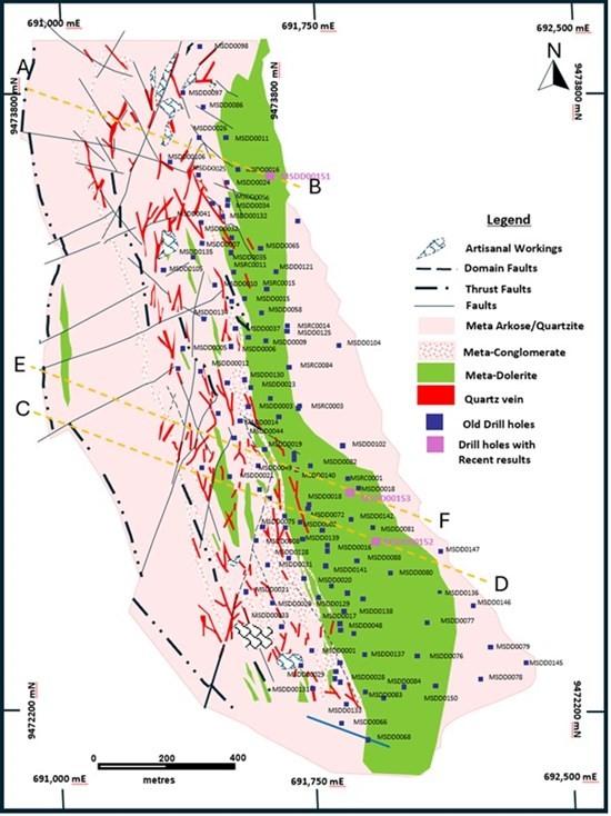
 

Figure 1: Akyanga Deposit Plan View with Drill hole locations


As shown in Figure 1, drill holes MSDD0151, MSDD0152 and MSDD0153 totalled 981.35 metres and generated 463 samples for analysis at the SGS laboratory in Mwanza, Tanzania. Additional 150 samples from MSDD0153 (233.3 m to 385.5 m) have now been shipped to the Laboratory. The results from MSDD0151, MSDD0152 and the partial results from MSDD0153 provide additional geological and grade information within and below the US$1,500/oz pit shell used to constrain the current Mineral Resource Estimate and support continued testing of the Akyanga mineralized system at depth.


Figures 2, 3 and 4 illustrate cross-sections through MSDD0151, MSDD0152 and MSDD0153, and show the spatial relationship between the newly reported mineralized intervals, historical drilling and the current pit-constrained Mineral Resource.


MSDD0151 intersected multiple mineralized zones over a broad downhole interval, including 5.70 m at 8.01 g/t Au from 268.10 m. MSDD0152 returned multiple intervals, including 13.60 m at 2.00 g/t Au from 86.00 m. Partial results from MSDD0153 returned 11.50 m at 6.50 g/t Au from 166.30 m within the interpreted hanging wall of the mineralized system. Together, the results provide additional information on the geometry, distribution and grade characteristics of mineralization in these sections of the Akyanga Deposit and will inform follow-up drilling.
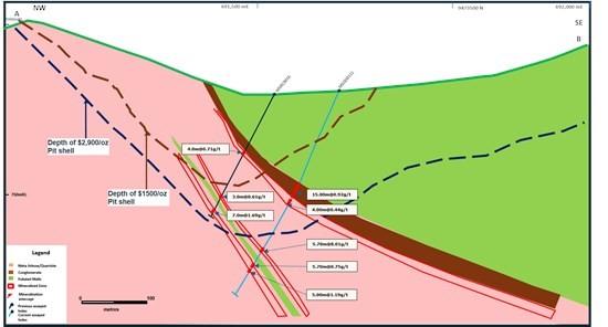
 

Figure 2: Cross section through hole MSDD0151
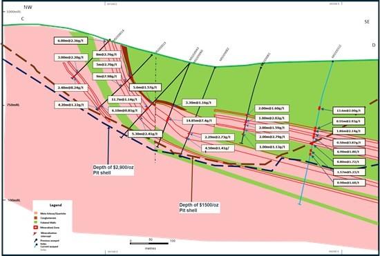
 

 Figure 3: Cross section through hole MSDD0152
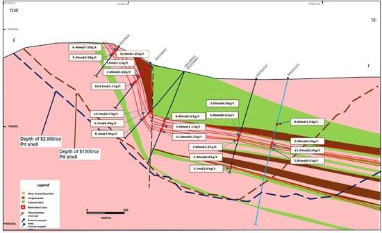
 

 Figure 4: Cross section through hole MSDD0153


MSDD0151 intersected multiple high-grade mineralized intervals, including 15.00 m at 0.92 g/t Au from 159.50 m, (including 0.60 m at 4.61 g/t Au from 160.20 m), 5.70 m at 8.01 g/t Au from 268.10 m; (Including 1.70 m at 23.47 g/t Au from 269.10 m), 5.70 m at 0.75 g/t Au from 290.60 m and 5.00 m at 1.19 g/t Au from 304.70 m.


MSDD0152 intersected several significant mineralized zones, including 13.60 m at 2.00 g/t Au from 86.00 m; (Including 0.48 m at 31.06 g/t Au from 87.70 m), 0.55 m at 2.93 g/t Au from 127.35 m, 1.86 m at 2.14 g/t Au from 131.90 m, 0.50 m at 3.87 g/t Au from 143.20 m, 6.90 m at 1.80 g/t Au from 147.90 m, and 1.57 m at 5.23 g/t Au from 191.7 m.


Partial results within the hanging wall of MSDD0153 intersected several significant mineralized zones, including 4.60 m at 1.94 g/t Au from 118.00 m, 2.90 m at 0.50 g/t Au from 157.00 m and 11.50 m at 6.50 g/t Au from 166.30 m.


1Table 1: Significant intercepts


Hole ID Drill Collar Location From To Intercept Grade Comments
Type m E m N m E (meters) (g/t Au)
MSDD0151 DD 691624 9473552 906.07 159.50 174.50 15.00 0.92 Inclu 0.60 @ 4.61 g/t Au from 160.2 m
MSDD0151 DD 268.10 273.80 5.70 8.01 incl 1.7 m@ 23.47g/t from 269.1m
MSDD0151 DD 290.60 296.30 5.70 0.75
MSDD0151 DD 304.70 309.70 5.00 1.19
MSDD0152 DD 691982.1 9472628 872.83 86.00 99.60 13.60 2.00 incl 0.48 m @31.06 g/t from 87.7m
MSDD0152 DD 127.35 127.90 0.55 2.93
MSDD0152 DD 131.90 133.76 1.86 2.14
MSDD0152 DD 143.20 143.70 0.50 3.87
MSDD0152 DD 147.90 154.80 6.90 1.80
MSDD0152 DD 163.80 164.60 0.80 1.72
MSDD0152 DD 191.66 193.23 1.57 5.23
MSDD0152 DD 202.18 203.35 1.17 1.68
MSDD0153 DD 691914.6 9472758 878.94 118.00 122.60 4.60 1.94
MSDD0153 DD 157.00 159.90 2.90 0.50
MSDD0153 DD 166.30 177.80 11.50 6.50 incl 1.4 m @ 12.68 g/t from 166.3 m;
3.0 m @11.99 g/t from 170.7m
MSDD0153 DD 183.15 187.00 3.85 0.51


1Intercepts are reported as downhole lengths. True widths are estimated to be approximately 85% of reported downhole lengths based on current geological interpretation. Grades are calculated as length-weighted averages of uncut assay results.


GEOLOGY AND MINERALISATION

The geology of the Misisi project area is dominated by Proterozoic meta-sediments comprising interbedded quartz muscovite schists, schistose arkoses, muscovite quartzites, and quartzites; pebble conglomerates and foliated mafic intrusion. Gold mineralisation is associated with numerous zones of stacked quartz veins that occur sub-parallel to bedding. The mineralised zones have strike lengths of up to 2,000 m and are generally less than 10 m thick. At the southern end of the Akyanga deposit the vein zones dip moderate to shallowly to the southeast. In the central and northern part, the deposit steepens at surface, such that at the northern end the mineralisation is near vertical at surface and flattening out down dip. The depth of weathering is estimated to be approximately 30 m. Mineralisation is structurally and lithologically controlled, in association with local deformation zones, and occurs along north-south striking structures. The current interpretation is that the base of a mafic unit provides a contact with hardness contrast along which there has been structural movement.


ACCELERATED EXPLORATION STRATEGY

The Company has adopted a phased exploration strategy designed to maximize drilling productivity while rapidly advancing resource growth.

  • Expand the existing resource footprint;
  • Upgrade confidence in the current resource;
  • Test extensions of known mineralization; and
  • Generate geological data to support future resource growth


UPCOMING NEWS FLOW


The Company expects a strong pipeline of exploration milestones over the coming months, including:

  • Commencement of Phase 2 drilling
  • Ongoing drill assay releases;
  • Resource growth drilling of the Akyanga mineral resource; and
  • Continued advancement toward future resource updates and technical studies initial drilling results from regional exploration targets across the Misisi Project


ABOUT AVANTI GOLD CORP

Avanti Gold Corporation is a gold exploration company focused on advancing its flagship Misisi Project in the Democratic Republic of Congo (DRC), home to the high-grade Akyanga gold deposit. The Akyanga deposit has an Inferred Mineral Resource of 40.8 million tonnes (Mt) at an average gold grade of 2.37 grams per tonne (g/t), totaling 3.11 million ounces (Moz) of gold. The Misisi Project spans three contiguous 30-year mining leases covering 133 square kilometers (km²) along the 55-kilometer-long Kibara Gold Belt, a prominent metallogenic province known for hosting significant gold deposits. A 42,000-metre drill program, the largest in the project’s history, is now underway with the objective of growing gold resources in advance of a Preliminary Economic Assessment anticipated in 2027.


QUALIFIED PERSONS STATEMENT


Ephraim Masibhera, B.Sc. Geol (UZ), MSc Cd, MGSSA, Pr.Sci.Nat, Technical Director, at Kweneng Group, an independent Qualified Person as defined by NI 43-101, has reviewed and approved the scientific and technical information contained in this news release. The drill holes referenced in this news release, MSDD0151 , MSDD0152 and MSDD0153, form part of the Company’s ongoing 2026 Phase 1 drilling program at the Akyanga Deposit. The Qualified Person reviewed the available drill collar, down-hole survey, geological logging, sampling, chain-of-custody and QA/QC information and considers the data adequate for the purposes of this disclosure.


Posted September 16, 2026

Share this news article

MORE or "UNCATEGORIZED"


Aya Gold & Silver Reports High-Grade Silver Exploration Results Near Pit and at Depth at Zgounder

Aya Gold & Silver Inc. (TSX: AYA; NASDAQ: AYA) is pleased to... READ MORE

September 16, 2026

New Break Resources Ltd. (CSE: NBRK) (OTCQB: NBRKF) (FSE: O91) has received results from the last four holes of a ten-hole, 1,996 metre summer drilling program in the Zavitz gold zone at the Company's 100% owned Moray gold project. In total, New Break has completed 5,372 metres of drilling in 32 drillholes in 2026. Moray is located 49 km southeast of Timmins, Ontario and 32 km northwest of the Young-Davidson gold mine operated by Alamos Gold Inc. Select results from the final four of ten holes drilled in the summer drilling program are presented below in Table 1, while drillhole collar locations are detailed in Table 2 in Appendix A. Table 1 – Moray Summer 2026 Final Drill Results Hole ID Length (m) From (m) To (m) Width (1) (m) Au Grade (2) (g/t) NBR-26-29 322.0 77.3 78.8 1.5 0.42 and 138.0 139.1 1.1 0.38 and 162.5 173.3 10.8 (3) 1.61 and 227.4 229.0 1.6 1.21 and 231.5 232.1 0.6 1.72 NBR-26-30 250.0 37.0 38.0 1.0 0.30 and 102.8 103.5 0.7 0.60 and 121.5 122.5 1.0 0.36 and 124.5 125.5 1.0 0.33 and 128.5 129.0 0.5 0.90 and 131.0 132.0 1.0 0.36 and 169.8 174.0 4.2 2.65 and 178.0 179.5 1.5 0.77 and 183.5 186.6 3.1 1.22 and 190.0 190.5 0.5 1.06 and 191.5 192.5 1.0 1.48 and 196.0 200.5 4.5 2.53 and 203.5 204.0 0.5 2.15 and 206.5 212.0 5.5 1.57 NBR-26-31 274.0 169.0 170.5 1.5 0.37 and 184.5 186.0 1.5 0.51 and 197.0 200.0 3.0 0.94 and 201.5 202.0 0.5 0.50 and 203.5 210.0 6.5 (3) 3.12 NBR-26-32 352.0 73.5 74.0 0.5 0.44 and 174.0 174.6 0.6 0.52 and 194.0 195.0 1.0 0.66 and 199.8 203.3 3.5 2.29 and 227.3 228.0 0.7 0.97 (1) Intervals are drill intersections and do not necessarily represent true widths. (2) All intervals are presented using a cut-off grade of 0.3 g/t Au and internal dilution of no more than 1.0 metres at grades less than 0.3 g/t Au and assays are not capped (see QA/QC Procedures). (3) Drill core photos shown in Appendix B. Figure 1 – Newly Reported Drillholes NBR-26-29, 30 Figure 2 – Newly Reported Drillholes NBR-26-30, 31, 32 Note: The bottom of NBR-26-30 deviated southeast and is represented in both sections. Figure 1: Section B-B1 incorporates drillholes NBR-26-06, 07, 08, 25, 26, 27, 28, 29 and part of 30. Gold mineralization extends southeast into the syenite as exhibited in NBR-26-29. NBR-26-30 is identified in both sections A-A1 and B-B1 as the drillhole was collared along section A-A1 but deviated southeast, intersecting gold mineralization in the mafic volcanics in section B-B1. Figure 2: A-A1 incorporates drillholes NBR-26-03, 04, 05, 23, 24, 30, 31 and 32. NBR-26-31 exhibits gold mineralization both within the syenite (at the contact) and within a "flow breccia" within the hematite altered mafic volcanic at the contact. NBR-26-32 is typified by blocky faulted ground with lamprophyre dykes and gold mineralization in the hematite altered mafic volcanics in a brecciated quartz vein with angular syenitic fragments. William Love, Chief Executive Officer of New Break commented, "Ongoing drilling this summer in the Zavitz gold zone continues to deliver significant gold values, with gold mineralization intercepted in every drillhole. As depicted in Figures 1 and 2, gold mineralization has been encountered predominantly within the mafic volcanics. Importantly, drillholes NR-26-29 and NR-26-32, the deepest drilled to date, demonstrate that gold mineralization extends into the syenite to the southeast at the contact with the mafic volcanics." He further noted, "The intrusive-mafic volcanic contact in the Zavitz gold zone has a distinctive magnetic high. This could be reflective of the higher proportion of iron in these mafic volcanics, which is associated with the higher gold values. This same magnetic and IP signature has been identified elsewhere in areas also believed to be along the intrusive-mafic volcanic contact. Drilling these never before tested targets with the goal of identifying gold mineralization similar to that encountered in the Zavitz zone represents the potential for significantly expanding the Moray gold discovery. There is also the belief that the Zavitz zone could represent the first of a series of stacked mineralized gold zones, which would point to the potential for a much larger gold system at depth. We plan to test this through deeper drilling directly into the Zavitz zone." About the Moray Gold Project The Moray property is located in the heart of the Ontario Abitibi greenstone belt, 49 km southeast of Timmins surrounded by a number of significant gold producing companies and existing mills (see Figure 3). The Young-Davidson gold mine operated by Alamos Gold Inc., with its 8,000 tonne per day mill is the closest and within a short trucking distance of approximately 45 km by road from Moray. The understanding of gold mineralization at Moray continues to evolve with each round of drilling. The occurrence of gold mineralization extending into the syenite to the southeast of the Zavitz zone and in the deepest drillholes is noteworthy given the presence of syenite-hosted mineralization at Young-Davidison. More recent examination of the drill core also suggests that the gold mineralization discovered to date may resemble an intrusion related style of deposit like Agnico Eagle's Upper Beaver gold deposit east of Kirkland Lake, as opposed to a structurally hosted gold system. Both Young-Davidson and Upper Beaver host multi-million ounce gold deposits. Figure 3 – Moray Location Map: Surrounding Gold Producers and Upper Beaver Gold Project Technical Content and Qualified Person The scientific and technical information contained in this news release has been reviewed and approved by Peter C. Hubacheck, P. Geo, consulting geologist to New Break, and an independent Qualified Person as defined by National Instrument 43-101. Mr. Hubacheck certifies that this news release fairly and accurately reflects the technical information and data presented. New Break conducts its exploration activities in accordance with CIM Best Practices Guidelines. QA/QC Procedures QA/QC procedures were executed to ensure all work is conducted in accordance with best practices. All drill core was sawn in half with one half of the core prepared for shipment and the other half retained for future verification. All core is under watch from the drill site to the core processing facility. Drill core is BQTK size and sample intervals range from 0.5 metres to 1.0 metres in length. Commercially prepared certified reference material ("CRM") standards and blanks were inserted with each shipment at a rate of 1 QAQC sample in every 12 core samples. Samples from New Break's 2026 Moray drilling program were analyzed at Activation Laboratories in Timmins, Ontario, which is ISO 17025 certified, by 30-gram fire assay with atomic absorption finish. Any sample assaying greater than 10.0 g/t Au was re-assayed with fire assay gravimetric analysis. Grade composite intervals over core lengths are calculated using a weighted average grade with a cut-off grade of 0.3 g/t Au. Up to 1.0 m of internal dilution (consecutive interval below cut-off grade) are included within specific geologic domains and alteration assemblages, except as otherwise noted. The composites are constrained geologically by metasomatic alteration processes sourcing from the Fiset syenite intrusion and contact mafic volcanic rocks. Elevated gold values are coincident with hematite, silica, sericite and pyrite mineralization within structurally prepared brecciated corridors flanking the intrusion. Intervals are not true widths and no top cutting has been applied to the higher gold values. About New Break Resources Ltd. New Break is a Canadian mineral exploration company focused on its Moray gold project located 49 km southeast of Timmins, Ontario, in a well-established mining camp within proximity to existing infrastructure, and 32 km northwest of the Young-Davidson gold mine, operated by Alamos Gold Inc. Shareholders are also leveraged to exploration success in Nunavut, Canada, through New Break's 20% carried interest in the Sundog gold project and ownership of 6.0 million shares of Guardian Exploration Inc. (TSXV: GX). The Company is supported by a highly experienced team of mining professionals. Appendix A – Drillhole Data and Locations Table 2 – Moray Summer 2026 Drillhole Collar Locations Hole ID Length (m) UTM Easting UTM Northing UTM Elevation Azimuth (degrees) Dip (degrees) NBR-26-29 322.0 492703 5320285 363 220 -70 NBR-26-30 250.0 492708 5320329 363 220 -47 NBR-26-31 274.0 492708 5320329 363 220 -60 NBR-26-32 352.0 492708 5320329 363 220 -70 Total 1,198.0 Coordinates are reported in UTM Zone 17 North, with units in metres. Figure 4 – Zavitz Gold Zone – Surface Traces of 2025 and 2026 Drillholes. All of the drilling at Moray has been completed by Enviro North Exploration Inc. out of Sturgeon Falls, Ontario. Drilling in the Zavitz gold zone is shown in figure 4, with the 1,996 metres in 10 holes drilled this summer depicted in red, the 2,807 metres in 20 holes drilled from January to April 2026 shown in blue and the 1,817 metres in 8 holes drilled in 2025 shown in black. In total, 6,620 metres in 38 drillholes have been completed in the Zavitz gold zone, while New Break has completed a total of 5,372 metres in 32 drillholes of our planned 2026, 10,000 metre drilling program. Appendix B – Drill Core Photos From NBR-26-29 and NBR-26-31

New Break Resources Ltd. (CSE: NBRK) (OTCQB: NBRKF) (FSE: O91) ha... READ MORE

September 16, 2026

New Found Gold Declares Commercial Production at Hammerdown Gold Mine

New Found Gold Corp. (TSX: NFGC) (NYSE American: NFGC) is pleased... READ MORE

September 16, 2026

G Mining Ventures Extends High-Grade Mineralization at Gurupi and Confirms Continuity at Depth at TZ

G Mining Ventures Corp. (TSX:GMIN | OTCQX:GMINF) provides an upda... READ MORE

September 16, 2026

Goliath Reports Multiple Holes With Visible Gold And Up To 13.81 g/t Au Over 4.85 Meters From Golden Gate Zone, 5.27 g/t AuEq Over 9.85 Meters From Surebet Zone At The High-Grade Gold Surebet Discovery that Remains Open for Expansion, Golden Triangle, B.C.

Assay results for drill holes GD-26-414, GD-26-426, GD-26-439, GD... READ MORE

September 16, 2026

Copyright 2026 The Prospector News
