


Arizona Metals Corp. (TSX-V:AMC) (OTCQX:AZMCF) is pleased to announce that it has received permit approval from the Bureau of Land Management for a drill pad, located approximately 200 m west of the Kay Mine deposit (pad 7 in Figure 1 below). This new pad will allow for testing of the Central Target (Figure 2), which was previously defined based on coincident structural, geochemical, and geophysical anomalies (Figure 3). The Company has planned an initial program at the Central Target of up to 20 holes totaling 11,000 m. Drilling on the first hole is currently underway. The Company has also submitted applications to the BLM for additional drill pads located west of the Central Target (pads C1 and C2 in Figure 1), which will allow for drill testing of the Central Target from the west side, while also allowing for drilling of additional coincident anomalies located between the Central and Western Targets.
Arizona Metals is also pleased to report that 4,909,999 common share purchase warrants, issued on April 22nd, 2021 with an exercise price of $3.00, were exercised prior to their April 22nd, 2022 expiry, with the result that the Company now has 111,372,104 common shares issued and outstanding. The exercise generated gross proceeds of $14,729,997, resulting in an increase of AMC’s working capital position to $65 million.
Marc Pais, CEO, commented “We are very pleased to announce that pad 7 was successfully permitted and the first hole of the initial 11,000 m Central Target program is already underway. These first 20 holes planned will all target areas previously untested by drilling, but that have many of the same characteristics we see at the Kay Mine deposit. This also marks the initiation of the larger, fully-funded Phase 3 program, which will total at least 76,000 m and cover the western extent of the Kay Mine Project. Two drill rigs continue to turn at the Kay Deposit, with concurrent goals of discovery and resource definition. We would also like to thank our shareholders for their continued support; the warrant exercises completed last week have increased the treasury to $65 million, and placed the Company on very strong footing to undertake the first detailed exploration of the Central and Western Targets in the known history of the property.”
The Company has completed a total of 54,000 meters at the Kay Mine since inception of drilling. The Company is fully-funded to complete the remaining 21,000 meters planned for the Phase 2 program with the priority focus areas for upcoming drilling, as well as an additional 76,000 meters in the upcoming Phase 3 program (including the 11,000 m announced for the Central Target today) which will be used to test the numerous parallel targets heading West of Kay and the Northern and Southern Extensions of the Kay Deposit. There are currently 21 holes pending results from drilling at the Kay Mine deposit.
About Arizona Metals Corp
Arizona Metals Corp owns 100% of the Kay Mine Property in Yavapai County, which is located on a combination of patented and BLM claims totaling 1,300 acres that are not subject to any royalties. An historic estimate by Exxon Minerals in 1982 reported a “proven and probable reserve of 6.4 million short tons at a grade of 2.2% copper, 2.8 g/t gold, 3.03% zinc, and 55 g/t silver.” The historic estimate at the Kay Mine was reported by Exxon Minerals in 1982. The historic estimate has not been verified as a current mineral resource. None of the key assumptions, parameters, and methods used to prepare the historic estimate were reported, and no resource categories were used. Significant data compilation, re-drilling and data verification may be required by a “qualified person” (as defined in National Instrument 43-101 – Standards of Disclosure for Mineral Projects) before the historic estimate can be verified and upgraded to be a current mineral resource. A qualified person has not done sufficient work to classify it as a current mineral resource, and Arizona Metals is not treating the historic estimate as a current mineral resource.
The Kay Mine is a steeply dipping VMS deposit that has been defined from a depth of 60 m to at least 900 m. It is open for expansion on strike and at depth.
The Company also owns 100% of the Sugarloaf Peak Property, in La Paz County, which is located on 4,400 acres of BLM claims. Sugarloaf is a heap-leach, open-pit target and has a historic estimate of “100 million tons containing 1.5 million ounces gold” at a grade of 0.5 g/t (Dausinger, 1983, Westworld Resources).
The historic estimate at the Sugarloaf Peak Property was reported by Westworld Resources in 1983. The historic estimate has not been verified as a current mineral resource. None of the key assumptions, parameters, and methods used to prepare the historic estimate were reported, and no resource categories were used. Significant data compilation, re-drilling and data verification may be required by a qualified person before the historic estimate can be verified and upgraded to a current mineral resource. A qualified person has not done sufficient work to classify it as a current mineral resource, and Arizona Metals is not treating the historic estimate as a current mineral resource.
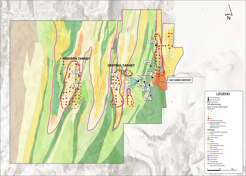
Figure 1. Plan view showing pad 7, located between the Kay Mine and the Central Target, as well as 20 planned drill holes totaling 11,000 m. The first hole is currently underway. (Photo: Business Wire)
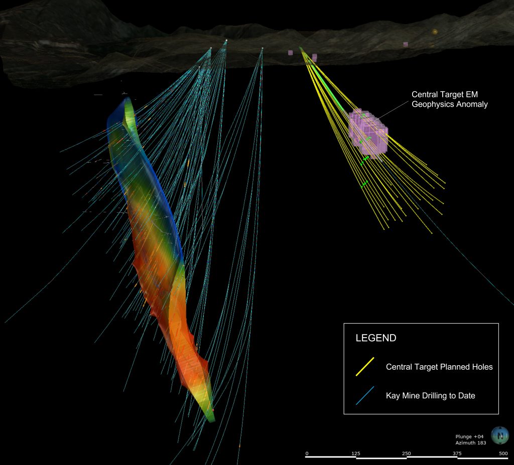
Figure 2. Section view looking south, showing planned drill holes of initial 11,000 m program to test the Central Target (located approximately 300 m west of the Kay Mine). (Photo: Business Wire)
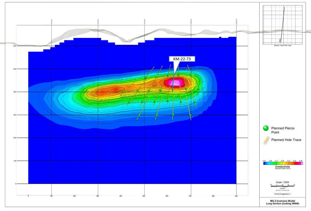
Figure 3. Long section looking WNW at Central Target electromagnetic anomaly. Hole KM-22-73 is currently underway, with green dots representing proposed pierce points for future holes. (Photo: Business Wire)
Masivo Silver Corp. (TSX-V: MASS) (OTC Pink: GNYPF) (FSE: R74) is... READ MORE
Spanish Mountain Gold Ltd. (TSX-V: SPA) (FSE: S3Y) (OTCQB: SPAUF)... READ MORE
NevGold Corp. (TSX-V:NAU) (OTCQX:NAUFF) (Frankfurt:5E50) is pleas... READ MORE
SAGA Metals Corp. (TSX-V: SAGA) (OTCQB: SAGMF) (FSE: 20H) a No... READ MORE
Revival Gold Inc. (TSX-V: RVG) (OTCQX: RVLGF) is pleased to provi... READ MORE


