The Prospector News

Alaska Energy Metals Discovers Broad Zones Of Nickel With Other Critical Metals At The Canwell Property, Nikolai Project, Alaska

You have opened a direct link to the current edition PDF

Open PDF Close
Uncategorized

Share this news article

Alaska Energy Metals Discovers Broad Zones Of Nickel With Other Critical Metals At The Canwell Property, Nikolai Project, Alaska

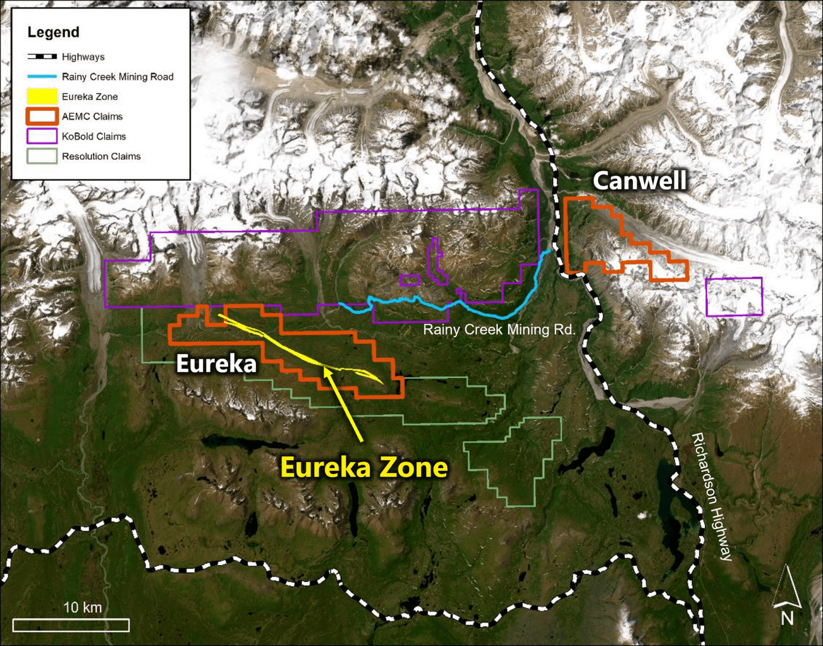
Alaska Energy Metals Corporation (TSX-V: AEMC) (OTCQB: AKEMF) is pleased to announce analytical results of its 2024 inaugural exploration drilling program at the Canwell claim block, which forms part of the Nikolai Project in Alaska. The Canwell prospects, Emerick, Odie and Upper Canwell, are located approximately 30 kilometers northeast of the Company’s nickel-rich Eureka deposit, which contains five materials designated by the US Government as critical metals: nickel, cobalt, chromium, platinum, and palladium. The deposit also contains copper, iron and gold (Figure 1).

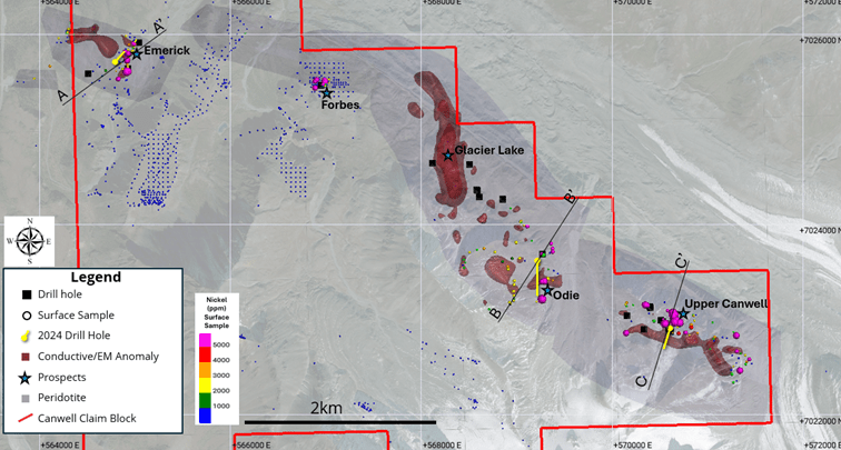
The 2024 Canwell drill program was completed using one surface diamond drill rig (Figure 2). The program consisted of three holes, totaling 1,047.9 meters (m). One hole was drilled into each of the three target prospects (Table 1) to test compelling geological, geophysical, and geochemical targets (Figure 3).

Alaska Energy Metals Chief Geologist Gabe Graf commented: “After 20 years of limited exploration on the Canwell property, the information collected from these drill holes will aid our understanding of the mineralized ultramafic systems within the Wrangellia Terrane of interior Alaska. In fact, the blebby sulfides intersected at the Upper Canwell prospect is the first subsurface indication for higher-grade sulfides on the property. Furthermore, the potential for coarser-grained nickel sulfides and additional disseminated sulfide zones on the Nikolai Project is encouraging, and we are excited to continue advancing the geologic understanding of the property. We look forward to getting back into these areas in the next exploration season.”


HIGHLIGHTS
  • Alaska Energy Metals received assay results from three drill holes completed on the Canwell claim block at the Emerick, Odie and Upper Canwell prospects. Significant thicknesses of polymetallic mineralization were intersected including:
    • CAN-24-001 (Emerick) – 56.5 meters @ 0.40% nickel equivalent (NiEq) (0.26% Ni, 0.62% Cr, 7.00% Fe, 0.012% Co, 0.01% Cu, 0.019 ppm Pd, 0.032 ppm Pt & 0.007 ppm Au)
    • CAN-24-002 (Odie) – 193.6 meters @ 0.42% NiEq (0.26% Ni, 0.69% Cr, 8.58% Fe, 0.01% Cu, 0.014% Co, 0.035 ppm Pd, 0.041 ppm Pt and 0.007 ppm Au)
    • CAN-24-003 (Canwell) – 429.3 meters @ 0.39% NiEq (0.24% Ni, 0.64% Cr, 8.12% Fe, 0.01% Cu, 0.013% Co, 0.031 ppm Pd, 0.035 ppm Pt and 0.007 ppm Au), including 1.4 meters @ 0.93 NiEq (0.65% Ni, 0.66% Cr, 8.90% Fe, 0.06% Cu, 0.021% Co, 0.275 ppm Pd, 0.246 ppm Pt and 0.012 ppm Au)
  • The confirmation of nickel mineralization has provided valuable data on the potential for additional nickel mineralization systems across the Nikolai district. These results provide the justification for additional drilling at Canwell with the goal of expanding disseminated sulfides zones and testing for massive sulfide mineralization.


Figure 1. Nikolai Project – Property Location Map
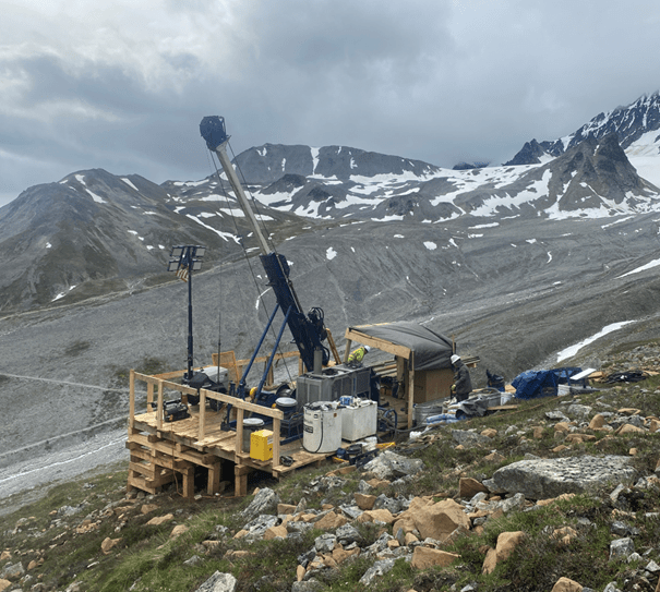
Figure 2. Diamond drill rig on the Odie Prospect, Canwell claims, Nikolai Project.

Table 1. Drill locations, azimuth and total depth for 2024 Inaugural Canwell drill holes

Canwell 2024 Completed Drill Holes
Drill hole # Prospect Easting (NAD 83 Zone 6N) Northing (NAD 83 Zone 6N) Drill Hole Collar EL (NAD 83 Zone 6N) Dip  Azimuth End of Hole Depth (m)
CAN-24-001 Emerick 564849 7025792 907 -50 38 74.8
CAN-24-002 Odie 569198 7023575 1329 -50 165 527
CAN-24-003 Upper Canwell 570631 7022894 1468 -70 195 446.1

Figure 3. Overview map of the Canwell claim block with surface sampling results, location of historical drill holes, geophysical anomalies and completed drill holes for 2024.


Note: The drill intercepts in this press release are reported as nickel equivalent for convenience in representing the polymetallic mineralization. The reported grade is for total in-situ, gross metal content and does not account for metal recoveries, the type of metal concentrates that might be produced from the rock, or the marketability and prices that may be paid for concentrates. The Company has done testing to determine the percentage of nickel that appears to be in metallic or sulfide form. These results are reported below with each drill hole. Some nickel is likely locked in silicate minerals and therefore not recoverable. However, based on this additional assay work and visual observation, it appears a significant amount of the reported nickel is in sulfide or metallic form. Metal prices used for the equivalent calculation are (US$): nickel – $9.00 per pound, copper – $4.25 per pound, cobalt – $14.00 per pound, platinum – $950 per ounce, palladium – $1,200 per ounce, gold – $2,000 per ounce, iron – $80 per tonne and chromium – $1.03 per pound. The true thickness of the reported drill intercepts is not known as there is insufficient geological information.

EMERICK PROSPECT SUMMARY (CAN-24-001)

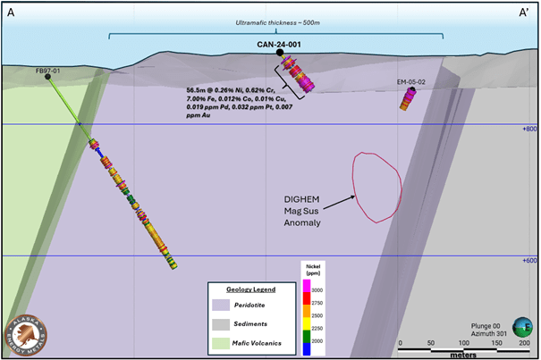
  • CAN-24-001 intersected 16.0 meters of overburden followed by serpentinized peridotite with varying amounts of sulfide minerals (0.2 – 0.5%) to a depth of 72.5 meters. Sulfide estimations were difficult due to intense fracturing, clay alteration, and serpentinization of the peridotite. Multiple, non-mineralized, mafic dikes were intersected within the peridotite. Rock conditions were very difficult for drilling. The hole was lost at 74.8 meters due to a large fault and did not intersect the targeted DIGHEM magnetic susceptibility anomaly or the interpreted base of the ultramafic intrusion. Rather than attempt to redrill the hole, a decision was made to defer further drilling on this target until 2025.
  • Mineralized peridotite intervals, including narrow zones of unmineralized mafic dikes, assayed (Table 2 & Figure 4):
    • 56.5 meters @ 0.40% NiEq (0.26% Ni, 0.62% Cr, 7.00% Fe, 0.012% Co, 0.01% Cu, 0.019 ppm Pd, 0.032 ppm Pt & 0.007 ppm Au)
      Including:
  • 9.9 m @ 0.45% NiEq (0.29% Ni, 0.67% Cr, 7.96% Fe, 0.013% Co, 0.01% Cu, 0.037 ppm Pd, 0.064 ppm Pt & 0.013 ppm Au)
  • 11.6m @ 0.43 NiEq (0.29% Ni, 0.67% Cr, 7.03% Fe, 0.013% Co, 0.01% Cu, 0.029 ppm Pd, 0.028 ppm Pt & 0.009 ppm Au)
  • 28.3m @ 0.44 NiEq (0.30% Ni, 0.71% Cr, 6.19% Fe, 0.013% Co, 0.013 ppm Pd, 0.028 ppm Pt & 0.006 ppm Au)
  • Nine selected samples were assayed to determine the proportion of nickel in sulfide/metallics. The results found that between 41% to 95% of the total assayed nickel is hosted within sulfide/metallics with the remaining nickel in other phases.


Table 2. Significant Intersections from CAN-24-001 (Emerick Prospect)
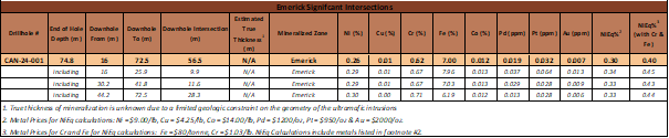
 

Figure 4. Cross section through CAN-24-001. Location of section line A-A’ displayed on Figure 3. Drillhole FB97-01 was drilled by Falconbridge in 1997. EM-05-02 was drilled by bcMetals in 2005.


ODIE PROSPECT SUMMARY (CAN-24-002)

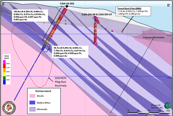
  • CAN-24-002 intersected 12.2 meters of overburden followed by serpentinized dunite with varying amounts of nickel sulfide and Ni-Fe alloy (0.2 – 6.0%) to a depth of 245.5 meters. Multiple, non-mineralized, gabbroic dikes were intersected within the dunite. An unmineralized diorite intrusion was intersected at 245.5 m and extends to 527.0 m. The targeted DIGHEM magnetic susceptibility anomaly is interpreted to correspond to the contact of the mineralized dunite and the diorite intrusive body, which contains an increase of pyrrhotite.
  • Mineralized dunite intervals, including narrow zones of unmineralized gabbro dikes, assayed (Table 3 and Figure 5):
    • 193.6m @ 0.42% NiEq (0.26% Ni, 0.69% Cr, 8.58% Fe, 0.01% Cu, 0.014% Co, 0.035 ppm Pd, 0.041 ppm Pt, 0.007 ppm Au)
    • 39.7m @ 0.33% NiEq (0.20% Ni, 0.60% Cr, 7.79% Fe, 0.01% Cu, 0.011% Co, 0.020 ppm Pd, 0.030 ppm Pt, 0.008 ppm Au)
  • Twenty-two selected samples were assayed to determine the proportion of nickel in sulfide/metallics. The results found that between 28% to 95% of the total assayed nickel is hosted within sulfide/metallics with the remaining nickel in other phases.


Table 3. Significant Intersections from CAN-24-002 (Odie Prospect)

 

Figure 5. Cross section through CAN-24-002. Location of section line B-B’ displayed on Figure 3. Drillholes CAN-DH-06 & CAN-DH-07 were drilled by Nevada Star Resources in 2004.


UPPER CANWELL PROSPECT SUMMARY (CAN-24-003)

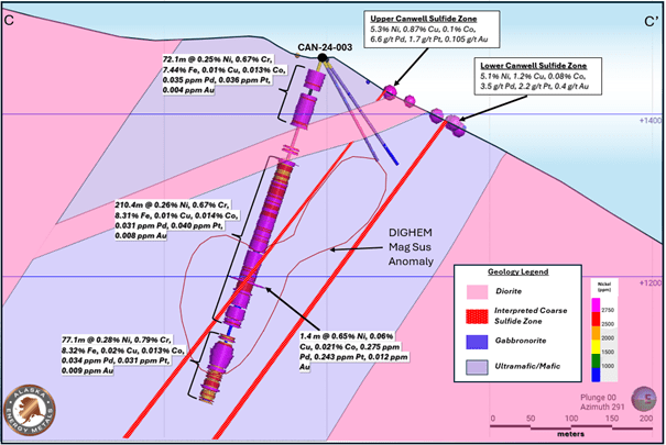
  • CAN-24-003 intersected 16.8 meters of overburden followed by serpentinized and faulted dunitic rocks with varying degrees of nickel sulfide and Ni-Fe alloy (0.5 – 5.0%) mineralization. Multiple cross cutting gabbroic dikes, with minimal sulfide mineralization, were intersected within the drill hole. Due to terrain challenges, the drill hole was moved north of the original planned collar to test both geophysical targets and resulted in drilling down dip of the intrusion. The targeted DIGHEM magnetic susceptibility anomaly contains elevated sulfide mineralization and nickel grades.
  • Mineralized dunite intervals, including narrow zones of unmineralized gabbro dikes, assayed (Table 4 and Figure 6):
    • 429.3 m @ 0.39% NiEq (0.24% Ni, 0.64% Cr, 8.12% Fe, 0.01% Cu, 0.013% Co, 0.031 ppm Pd, 0.035 ppm Pt and 0.007 ppm Au)Including:
      • 72.1 m @ 0.40% NiEq (0.25% Ni, 0.67% Cr, 7.44% Fe, 0.013% Co, 0.035 ppm Pd, 0.036 ppm Pt and 0.004 ppm Au) 
      • 210.4 m @ 0.41% NiEq (0.26% Ni, 0.67% Cr, 8.31% Fe, 0.01% Cu, 0.014% Co, 0.031 ppm Pd, 0.040 ppm Pt and 0.008 ppm Au) 
      • 77.1 m @ 0.45% NiEq (0.28% Ni, 0.79% Cr, 8.32% Fe, 0.02% Cu, 0.013% Co, 0.034 ppm Pd, 0.031 ppm Pt and 0.009 ppm Au) 
  • Twenty-one selected samples were assayed to determine the proportion of nickel in sulfide/metallics. The results found that between 20% to 89% of the total assayed nickel is hosted within sulfide/metallics with the remaining nickel in other phases.
  • Blebby nickel sulfides were intersected within a brecciated zone (Figure 7) from 289.3 m to 290.7 m, which assayed (Table 4 and Figure 6):
    • 1.4m @ 0.93% NiEq (0.65% Ni, 0.06% Cu, 0.021% Co, 0.66% Cr, 8.90% Fe, 0.275 ppm Pd, 0.246 ppm Pt & 0.012 ppm Au)


Table 4. Significant Intersections from CAN-24-003 (Upper Canwell Prospect)
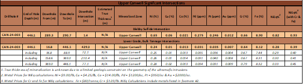
 

Figure 6. Cross-section through CAN-24-003. Location of section line C-C’ displayed on Figure 3.
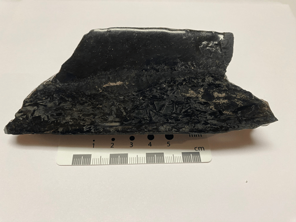
Figure 7. Blebby nickel sulfides within a brecciated zone at 290.6 meters downhole in CAN-24-003.

CORE PROCESSING & QUALITY ASSURANCE AND QUALITY CONTROL (QA/QC):

AEMC adheres to stringent Quality Assurance – Quality Control standards for its Nikolai Project to ensure the best practices for logging, sampling, and analysis of samples. For every 10 core samples, geochemical blanks, coarse reject or pulp duplicates, or Ni-Cu-PGE-Au certified reference material standards (CRMs) were inserted into the sample stream.

Drill core was flown by helicopter daily from drill sites and transported in secured wooden core boxes to the core logging facilities at the McLaren River Lodge, Alaska. Logged drill core and sample data were captured on tablets using MX Deposit software. Samples were labeled by geologists and sawn in half with a diamond blade, with half being inserted into a labeled, bar-coded, sample bag. The other half of the core was returned to the wooden boxes and archived at a secure facility. Samples were transported to SGS Laboratories (SGS) in Burnaby, B.C. using a contracted transportation carrier.

Once samples were received at the SGS they were weighed, dried, and crushed to 75% passing 2mm. The samples were riffle split and pulverized to 85% passing 75 microns. Au, Pt, & Pd were analyzed by fire assay with ICP-AES finish (GE_FAI30V5). Ag was analyzed using a 4-acid digest with AAS finish (GE_AAS42E50). The remaining 30 elements were analyzed using sodium peroxide fusion with ICP-AES finish (GE_ICP90A50). Metallic and sulfide nickel was analyzed using bromine-methanol leach with AAS finish (GC_AAS03D).

Mineralized intersections are reported as drill lengths and were calculated by AEMC personnel. These calculated intersections do not necessarily represent true thickness due to a limited geologic constraint on the geometry of the ultramafic intrusions at Canwell. Geologic interpretations presented in this news release have been completed by AEMC personnel and may be revised with additional geologic information.

QUALIFIED PERSON

Gabriel Graf, the Company’s Chief Geoscientist, is the qualified person, as defined under National Instrument 43-101 Standards of Disclosure for Mineral Projects, responsible for reviewing and approving the technical information contained in this news release.

For additional information, please visit: https://alaskaenergymetals.com/


ABOUT ALASKA ENERGY METALS

Alaska Energy Metals Corporation (AEMC) is an Alaska-based corporation with offices in Anchorage and Vancouver working to sustainably deliver the critical materials needed for national security and a bright energy future, while generating superior returns for shareholders.

AEMC is focused on delineating and developing the large-scale, bulk tonnage, polymetallic, multi-critical Eureka deposit containing five materials designated by the US Government as critical minerals: nickel, cobalt, chromium, platinum, and palladium — and copper, a Department of Energy Critical Material, plus iron and gold. Four of the deposit’s metals are designated Defense Production Act Title III materials, deemed “essential to national defense.”

Located in Interior Alaska near existing transportation and power infrastructure, our flagship project, Nikolai, is well-situated to become a significant domestic source of strategic energy-related metals for North America. AEMC also holds a secondary project in western Quebec, the Angliers – Belleterre project, which has the potential for high–grade nickel-copper sulfide deposits and white hydrogen.

Today, material sourcing demands excellence in environmental performance, carbon mitigation, and the responsible management of human and financial capital. AEMC works every day to earn and maintain the respect and confidence of the public and believes that ESG performance is measured by action and led from the top.

Posted November 21, 2024

Share this news article

MORE or "UNCATEGORIZED"


Critical Metals Corp Achieves Breakthrough Tanbreez Heavy Rare Earth Results: >99% Dissolution of Eudialyte Concentrate Into 19 Ultra-High-Purity Rare Earth Products; Refinery Study Projects US$1.8–2.2b in Annual Refinery Revenue

Critical Metals Corp. (Nasdaq: CRML) a leading critical minerals ... READ MORE

September 16, 2026

Metalsource Mining Extends High Grade Mineralization at Depth as Silver Hill Exploration Enters Major Expansion Phase

Holes SH26-22 and SH26-23 return up to 930 g/t AgEq within broade... READ MORE

September 16, 2026

Pasinex Completes Sale of High-Grade Zinc Sulphide Material and Provides Pinargozu Operations Update

Pasinex Resources Limited (CSE: PSE) (FSE: PNX) a growing zinc-fo... READ MORE

September 16, 2026

Aya Gold & Silver Reports High-Grade Silver Exploration Results Near Pit and at Depth at Zgounder

Aya Gold & Silver Inc. (TSX: AYA; NASDAQ: AYA) is pleased to... READ MORE

September 16, 2026

New Break Resources Ltd. (CSE: NBRK) (OTCQB: NBRKF) (FSE: O91) has received results from the last four holes of a ten-hole, 1,996 metre summer drilling program in the Zavitz gold zone at the Company's 100% owned Moray gold project. In total, New Break has completed 5,372 metres of drilling in 32 drillholes in 2026. Moray is located 49 km southeast of Timmins, Ontario and 32 km northwest of the Young-Davidson gold mine operated by Alamos Gold Inc. Select results from the final four of ten holes drilled in the summer drilling program are presented below in Table 1, while drillhole collar locations are detailed in Table 2 in Appendix A. Table 1 – Moray Summer 2026 Final Drill Results Hole ID Length (m) From (m) To (m) Width (1) (m) Au Grade (2) (g/t) NBR-26-29 322.0 77.3 78.8 1.5 0.42 and 138.0 139.1 1.1 0.38 and 162.5 173.3 10.8 (3) 1.61 and 227.4 229.0 1.6 1.21 and 231.5 232.1 0.6 1.72 NBR-26-30 250.0 37.0 38.0 1.0 0.30 and 102.8 103.5 0.7 0.60 and 121.5 122.5 1.0 0.36 and 124.5 125.5 1.0 0.33 and 128.5 129.0 0.5 0.90 and 131.0 132.0 1.0 0.36 and 169.8 174.0 4.2 2.65 and 178.0 179.5 1.5 0.77 and 183.5 186.6 3.1 1.22 and 190.0 190.5 0.5 1.06 and 191.5 192.5 1.0 1.48 and 196.0 200.5 4.5 2.53 and 203.5 204.0 0.5 2.15 and 206.5 212.0 5.5 1.57 NBR-26-31 274.0 169.0 170.5 1.5 0.37 and 184.5 186.0 1.5 0.51 and 197.0 200.0 3.0 0.94 and 201.5 202.0 0.5 0.50 and 203.5 210.0 6.5 (3) 3.12 NBR-26-32 352.0 73.5 74.0 0.5 0.44 and 174.0 174.6 0.6 0.52 and 194.0 195.0 1.0 0.66 and 199.8 203.3 3.5 2.29 and 227.3 228.0 0.7 0.97 (1) Intervals are drill intersections and do not necessarily represent true widths. (2) All intervals are presented using a cut-off grade of 0.3 g/t Au and internal dilution of no more than 1.0 metres at grades less than 0.3 g/t Au and assays are not capped (see QA/QC Procedures). (3) Drill core photos shown in Appendix B. Figure 1 – Newly Reported Drillholes NBR-26-29, 30 Figure 2 – Newly Reported Drillholes NBR-26-30, 31, 32 Note: The bottom of NBR-26-30 deviated southeast and is represented in both sections. Figure 1: Section B-B1 incorporates drillholes NBR-26-06, 07, 08, 25, 26, 27, 28, 29 and part of 30. Gold mineralization extends southeast into the syenite as exhibited in NBR-26-29. NBR-26-30 is identified in both sections A-A1 and B-B1 as the drillhole was collared along section A-A1 but deviated southeast, intersecting gold mineralization in the mafic volcanics in section B-B1. Figure 2: A-A1 incorporates drillholes NBR-26-03, 04, 05, 23, 24, 30, 31 and 32. NBR-26-31 exhibits gold mineralization both within the syenite (at the contact) and within a "flow breccia" within the hematite altered mafic volcanic at the contact. NBR-26-32 is typified by blocky faulted ground with lamprophyre dykes and gold mineralization in the hematite altered mafic volcanics in a brecciated quartz vein with angular syenitic fragments. William Love, Chief Executive Officer of New Break commented, "Ongoing drilling this summer in the Zavitz gold zone continues to deliver significant gold values, with gold mineralization intercepted in every drillhole. As depicted in Figures 1 and 2, gold mineralization has been encountered predominantly within the mafic volcanics. Importantly, drillholes NR-26-29 and NR-26-32, the deepest drilled to date, demonstrate that gold mineralization extends into the syenite to the southeast at the contact with the mafic volcanics." He further noted, "The intrusive-mafic volcanic contact in the Zavitz gold zone has a distinctive magnetic high. This could be reflective of the higher proportion of iron in these mafic volcanics, which is associated with the higher gold values. This same magnetic and IP signature has been identified elsewhere in areas also believed to be along the intrusive-mafic volcanic contact. Drilling these never before tested targets with the goal of identifying gold mineralization similar to that encountered in the Zavitz zone represents the potential for significantly expanding the Moray gold discovery. There is also the belief that the Zavitz zone could represent the first of a series of stacked mineralized gold zones, which would point to the potential for a much larger gold system at depth. We plan to test this through deeper drilling directly into the Zavitz zone." About the Moray Gold Project The Moray property is located in the heart of the Ontario Abitibi greenstone belt, 49 km southeast of Timmins surrounded by a number of significant gold producing companies and existing mills (see Figure 3). The Young-Davidson gold mine operated by Alamos Gold Inc., with its 8,000 tonne per day mill is the closest and within a short trucking distance of approximately 45 km by road from Moray. The understanding of gold mineralization at Moray continues to evolve with each round of drilling. The occurrence of gold mineralization extending into the syenite to the southeast of the Zavitz zone and in the deepest drillholes is noteworthy given the presence of syenite-hosted mineralization at Young-Davidison. More recent examination of the drill core also suggests that the gold mineralization discovered to date may resemble an intrusion related style of deposit like Agnico Eagle's Upper Beaver gold deposit east of Kirkland Lake, as opposed to a structurally hosted gold system. Both Young-Davidson and Upper Beaver host multi-million ounce gold deposits. Figure 3 – Moray Location Map: Surrounding Gold Producers and Upper Beaver Gold Project Technical Content and Qualified Person The scientific and technical information contained in this news release has been reviewed and approved by Peter C. Hubacheck, P. Geo, consulting geologist to New Break, and an independent Qualified Person as defined by National Instrument 43-101. Mr. Hubacheck certifies that this news release fairly and accurately reflects the technical information and data presented. New Break conducts its exploration activities in accordance with CIM Best Practices Guidelines. QA/QC Procedures QA/QC procedures were executed to ensure all work is conducted in accordance with best practices. All drill core was sawn in half with one half of the core prepared for shipment and the other half retained for future verification. All core is under watch from the drill site to the core processing facility. Drill core is BQTK size and sample intervals range from 0.5 metres to 1.0 metres in length. Commercially prepared certified reference material ("CRM") standards and blanks were inserted with each shipment at a rate of 1 QAQC sample in every 12 core samples. Samples from New Break's 2026 Moray drilling program were analyzed at Activation Laboratories in Timmins, Ontario, which is ISO 17025 certified, by 30-gram fire assay with atomic absorption finish. Any sample assaying greater than 10.0 g/t Au was re-assayed with fire assay gravimetric analysis. Grade composite intervals over core lengths are calculated using a weighted average grade with a cut-off grade of 0.3 g/t Au. Up to 1.0 m of internal dilution (consecutive interval below cut-off grade) are included within specific geologic domains and alteration assemblages, except as otherwise noted. The composites are constrained geologically by metasomatic alteration processes sourcing from the Fiset syenite intrusion and contact mafic volcanic rocks. Elevated gold values are coincident with hematite, silica, sericite and pyrite mineralization within structurally prepared brecciated corridors flanking the intrusion. Intervals are not true widths and no top cutting has been applied to the higher gold values. About New Break Resources Ltd. New Break is a Canadian mineral exploration company focused on its Moray gold project located 49 km southeast of Timmins, Ontario, in a well-established mining camp within proximity to existing infrastructure, and 32 km northwest of the Young-Davidson gold mine, operated by Alamos Gold Inc. Shareholders are also leveraged to exploration success in Nunavut, Canada, through New Break's 20% carried interest in the Sundog gold project and ownership of 6.0 million shares of Guardian Exploration Inc. (TSXV: GX). The Company is supported by a highly experienced team of mining professionals. Appendix A – Drillhole Data and Locations Table 2 – Moray Summer 2026 Drillhole Collar Locations Hole ID Length (m) UTM Easting UTM Northing UTM Elevation Azimuth (degrees) Dip (degrees) NBR-26-29 322.0 492703 5320285 363 220 -70 NBR-26-30 250.0 492708 5320329 363 220 -47 NBR-26-31 274.0 492708 5320329 363 220 -60 NBR-26-32 352.0 492708 5320329 363 220 -70 Total 1,198.0 Coordinates are reported in UTM Zone 17 North, with units in metres. Figure 4 – Zavitz Gold Zone – Surface Traces of 2025 and 2026 Drillholes. All of the drilling at Moray has been completed by Enviro North Exploration Inc. out of Sturgeon Falls, Ontario. Drilling in the Zavitz gold zone is shown in figure 4, with the 1,996 metres in 10 holes drilled this summer depicted in red, the 2,807 metres in 20 holes drilled from January to April 2026 shown in blue and the 1,817 metres in 8 holes drilled in 2025 shown in black. In total, 6,620 metres in 38 drillholes have been completed in the Zavitz gold zone, while New Break has completed a total of 5,372 metres in 32 drillholes of our planned 2026, 10,000 metre drilling program. Appendix B – Drill Core Photos From NBR-26-29 and NBR-26-31

New Break Resources Ltd. (CSE: NBRK) (OTCQB: NBRKF) (FSE: O91) ha... READ MORE

September 16, 2026

Copyright 2026 The Prospector News