


![]()
Alamos Gold Inc. (TSX:AGI) (NYSE:AGI) today reported new results from underground and surface exploration drilling at the Island Gold Mine. Exploration drilling has defined high-grade mineralization across multiple areas which are being targeted as sources of additional higher-grade mill feed within the expanded Magino mill.
This includes defining a new zone of high-grade mineralization 250 metres west of underground Mineral Reserves and Mineral Resources (Island Gold West Extension), and continuing to extend mineralization within the Island West up-plunge area. Given its proximity to surface, Island West up-plunge can be mined utilizing the ramp, providing further upside potential in terms of combined underground mining rates. Additionally, the regional exploration program continues to intersect high-grade gold mineralization at the past-producing Cline-Pick, and Edwards mines, located seven kilometres from the Magino Mill (see Figure 1).
“As outlined in the Expansion Study, the Island Gold District is expected to become one of the largest and lowest cost gold operations in Canada. Given our ongoing exploration success within the main Island Gold structure, and across multiple near mine targets, we expect there is further production growth to come. With multiple higher grade targets being defined within proximity to the Magino mill, and an expansion underway that will provide more than enough mill capacity, we see excellent potential to drive production higher by further increasing the proportion of higher-grade ore that will be processed within the expanded circuit,” said John A. McCluskey, President and Chief Executive Officer.
Island Gold West Extension Zone: high-grade mineralization has been intersected within a newly defined zone measuring approximately 200 by 300 m based on drilling to date. This new zone is located approximately 250 m to as much as 500 m along strike to the west of the existing Mineral Reserves and Resources of the Island Gold Deposit, and south of the Magino deposit. The zone remains open down-plunge and to the west, with drilling continuing to target extensions of the mineralization. New highlights include1:
Island West up-plunge: drilling continues to expand high-grade gold mineralization across multiple zones (C, D1, DN2, G1, G10). Given its proximity to surface, and the ability to be mined via the ramp system, the Island West up-plunge area represents significant opportunity to increase combined underground mining rates beyond the 3,000 tonnes per day that is expected to be mined and skipped to surface via the shaft. This would support further production growth by increasing the proportion of higher-grade ore to be processed within the expanded Magino mill. New highlights include2:
Island West up-plunge unknown zones: high-grade mineralization intersected across multiple yet to be defined zones in both the hanging wall and footwall. Additional drilling will be focused on defining these new zones through further assessing the geometry and continuity of these zones. New highlights include1:
Island Gold NS1 and NS4 Zone: high-grade gold mineralization intersected within new and recently defined hanging wall zones, NS1 and NS4. These zones are low-cost to develop, given their proximity to existing infrastructure. The NS1 Zone extends into the Island West up-plunge target area representing an additional opportunity to access high-grade ore from the existing ramp system. As exploration on the NS4 zone advances up-plunge, there is also the potential for this zone to extend into the Island West up plunge area. New highlights include2:
Cline-Pick Mine regional drilling: continues to extend high-grade gold mineralization beyond the extent of previous mining and following up on the best hole drilled to date announced earlier this year which intersected 178.07 g/t Au over 3.54 m (25IGX128). The targets remain open in multiple directions, including at depth, with the deepest holes drilled to date down to a vertical depth of only 540 m. The Cline-Pick, and adjacent past producing Edwards Mine are located within 7 km of the Magino mill and are being targeted as potential sources of additional higher-grade mill feed within the expanded mill. New highlights include3:
Cline-Pick Mines:
Edwards Mine:
88-60 Zone:
1 All reported composite intervals are composite core length, and gold grades are reported as uncut.
2 All reported composite intervals are calculated true width of the mineralized zones. Drillhole composite intervals reported as “cut” include higher grade samples which have been cut to: Island West (C-zone) and Island Main @ 230 g/t Au; B and NS1 Zone @ 90 g/t Au; D1 and G1 zone @ 45 g/t Au; G10 Zone @ 25 g/t Au, NS4 Zone @48 g/t Au; DN and DN2 @ 35 g/t Au.
3 All reported composite intervals reported as uncut, and composites lengths are reported as core length. True width is estimated to be 40–85% of core length unless otherwise indicated. Composites are calculated with a 0.5 g/t cut-off, maximum internal waste of 4 m, and no minimum length.
New highlight intercepts can be found in Tables 1 and 2, and in Figures 1 to 6 at the end of this news release.
2026 Exploration Drilling Program
A total of $43 million has been budgeted for exploration at the Island Gold District in 2026, up from $24 million spent in 2025. A significant focus of the 2025 drilling program at Island Gold and Magino was on delineation drilling to convert the large Inferred Mineral Resource base to Mineral Reserves. This program was executed successfully and resulted in a significant increase in Mineral Reserves at both Island Gold and Magino, which was incorporated into the Island Gold District Expansion Study announced on February 3, 2026. With the deposit open laterally and at depth, there is significant potential for further growth in Mineral Reserves and Resources.
A total of 50,000 m of underground exploration drilling is planned in 2026 with a focus on defining new Mineral Reserves and Resources in proximity to existing production horizons and infrastructure. This includes drilling across the strike extent of the main Island Gold deposit (E1E and C-Zones), as well as within a growing number of newly defined hanging wall and footwall zones. To support the underground exploration program, 1,090 m of underground exploration drift development is planned to extend drill platforms on multiple levels.
Additionally, 48,000 m of surface exploration drilling has been budgeted targeting the area between the Island Gold and Magino deposits, as well as the down-plunge extension of the Island Gold deposit, below a depth of 1,500 m.
The regional exploration program at the Island Gold District includes 16,000 m of surface drilling. The focus of the regional program will be following up on high-grade mineralization intersected in the 2025 drill program at Cline and Pick, which are located approximately 7 km northeast Magino mill. Drilling will also be completed at the historic Edwards mine, located in proximity to the Cline and Pick mines with the objective of extending mineralization beyond historically mined areas. Additionally, drilling will be completed at the Island Gold North Shear target, and to the east and along strike from the Island Gold mine to test the extension of the E1E-zone.
As of June 1, 2026, a total of 17,760 m of underground drilling was completed in 66 holes. Additionally, 13,023 m of surface exploration drilling has been completed in 17 holes focused on expansion of Island Gold to the east, west, and down-plunge. As part of the regional exploration program, 8,123 m of drilling has been completed in 13 holes and two extension holes.
The focus of this press release is on the variety of higher-grade upside opportunities that are being targeted beyond the main Island Gold underground structure. Ongoing success within the main structure is expected to support further growth in Mineral Reserves and Resources as drilling continues to advance across multiple areas, including Island East and down-plunge. Results from drilling within the main structure are expected to be released later in 2026.
Island Gold West Extension
High-grade mineralization was intersected in a new zone from seven holes (six surface and one underground), spaced approximately 40 m to 100 m apart. Assays are pending from four of the surface holes. This new zone is located 300 m along strike to the west of the current Island Gold Mine Mineral Reserves and Resources, and has currently been tested between 750 and 1,000 m from surface. Based on the initial drilling this new zone has been defined over an extent of approximately 200 m by 300 m and is open to the west and down-plunge. This zone is in an area that has seen very limited exploration, to the west of the “Creek Fault”, south of the Webb Lake Stock, and the Magino deposit. Only one historic hole (AR-390-01) was completed in this target area by Alamos in 2018, which intersected 7.03 g/t over 5.50 m including 38.74 g/t Au over 0.70 m, and was classified as an “Unknown” zone at that time.
Drilling will continue in this area from both surface and from underground drill platforms established in the western portion of the Island Gold Mine on the 490 and 790-levels.
New highlights include1 (Figure 2, Table 1):
1 All reported composite intervals are composite core length, and gold grades are reported as uncut.
Island West Up-Plunge
The Island West up-plunge area represents significant opportunity to support increased underground mining rates beyond the 3,000 tpd that is expected to be skipped to surface via the shaft. Given its proximity to surface, this area can be mined via the ramp system providing higher combined underground mining rates. This would increase the proportion of high-grade ore processed within the expanded Magino mill, supporting higher combined gold production. Surface and underground exploration drilling in 2026 has been focused on expanding high-grade gold mineralization within the Island West up-plunge area in multiple zones (C, D1, DN2, G1, G10) from 400 to 900 m below surface. Drilling remains focused on continuing to define additional high-grade mineralization in this area, up-plunge towards surface.
New highlights include2 (Figure 2, Table 1):
In addition, multiple high-grade intervals were intersected in the hanging wall and footwall of the Island West up-plunge area within yet to be defined zones. Additional drilling will be focused on defining new zones through further assessing their geometry and continuity.
New highlights from “Unknown zones” in the Island West up plunge area include1 (Table 1):
1 All reported composite intervals are composite core length, and gold grades are reported as uncut.
2 All reported composite intervals are calculated true width of the mineralized zones. Drillhole composite intervals reported as “cut” include higher grade samples which have been cut to: Island West (C-zone) and Island Main @ 230 g/t Au; B and NS1 Zone @ 90 g/t Au; D1 and G1 zone @ 45 g/t Au; G10 Zone @ 25 g/t Au, NS4 Zone @48 g/t Au; DN, DN2 @ 35 g/t Au.
Island West Hanging Wall NS-Zones
In addition to testing the main Island Gold structure (C-Zone), underground exploration drilling continued to target high-grade gold mineralization in sub-parallel and perpendicular structures in the hanging wall from the 850 and 1025-levels.
NS Hanging Wall Zones
The NS1 zone is a northwest-striking structure with a high-angle orientation relative to the C-Zone that was discovered in early 2023. The first stopes were mined from the NS1 zone during the second half of 2023, and it continues to be actively mined, highlighting the size and near-term opportunities within these hanging wall and footwall zones. Notably, the NS1 Zone extends into the Island West up-plunge target area representing an additional opportunity to access high-grade ore from the existing ramp system.
The NS4 zone is a northwest-striking structure discovered in 2024, 180 m west of and subparallel to the NS1 zone. To date, this zone has been defined over a vertical extent of 400 m, and an average strike of 300 m. As exploration on the NS4 zone advances up-plunge, there is also the potential for the NS4 zone to extend into the Island West up plunge area. Several other north-striking high-angle structures have been identified across the deposit from reinterpretation of historical hanging wall drilling, including the NS2 and NS3 zones which will be further drill tested in 2026. These structures will continue to be further evaluated as underground exploration drilling advances, and represent significant opportunities to continue to grow near mine Mineral Reserves and Resources which are low-cost to develop, given their proximity to existing infrastructure.
New highlights from the Island West Hanging Wall zones include2 (Table 1, Figure 2):
2 All reported composite intervals are calculated true width of the mineralized zones. Drillhole composite intervals reported as “cut” include higher grade samples which have been cut to: Island West (C-zone) and Island Main @ 230 g/t Au; B and NS1 Zone @ 90 g/t Au; D1 and G1 zone @ 45 g/t Au; G10 Zone @ 25 g/t Au, NS4 Zone @48 g/t Au; DN, DN2 @ 35 g/t Au.
Regional Exploration
Cline-Pick, and Edwards Mines, and 88-60 Zone
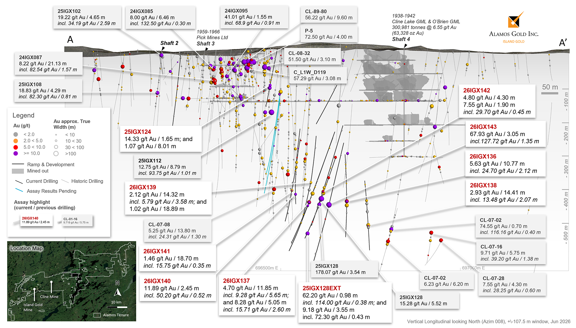
The Cline-Pick and Edwards mines are located 7 km by road northeast of the Magino mill (Figures 3 and 4). Alamos acquired these past-producing mines in 2020 as part of its consolidation of the northeastern segment of the Michipicoten Greenstone Belt with the acquisition of Trillium Mining Corp.
Since 2023, Alamos has completed 19,448 m of drilling in 56 holes at CEP as part of the regional drilling program. The 2026 regional exploration program includes 12,500 m focused at CEP with the objective of advancing the deposits towards a Mineral Resource estimate.
Drilling completed year to date continues to expand high-grade gold mineralization beyond the extent of historic mining. Extension of high-grade gold mineralization at these historic mines represent potential future sources of additional higher-grade ore within the expanded Magino mill.
The focus of the 2026 Cline-Pick drill program has been to follow up on drill hole 25IGX128 which returned 178.07 g/t Au over 3.54 m (see press release dated February 2, 2026). Drill hole 25IGX128, had targeted a 300 m gap in drilling, approximately 430 m from surface, where a moderate east plunging ore shoot is associated with a subvertical east-west trending shear zone. The vein has been interpreted as a moderate-steeply dipping shear-vein, with true width estimated at approximately 50% of core length.
Step out drilling is being completed within the shear zone at 40 to 75 m spacing, with the focus on further defining the geometry and orientations of both the shear and the veins, as well as determining the controls on gold mineralization. These holes represent some of the deeper holes drilled at Cline-Pick, intersecting the target zone down to a 510 m vertical depth, and the main structure remains open at depth and along strike.
New highlights include3 (Figure 5 and 6, Table 2):
Cline-Pick Mines:
Edwards Mine:
Two drill holes were also completed to the northeast of the Edwards Mine Shaft #1, testing for the potential extension of mineralization. Both holes intersected gold mineralization with the high-grade highlight in drill hole 25IGX133 which returned 5.06 g/t Au over 13.60 m, including 35.40 g/t Au over 0.80 m. Additional drilling will be completed in the second half of the 2026 following up on this drill hole. New highlights include:
Edwards Mine:
88-60 Zone:
Surface drilling targeting Cline-Pick at depth also intersected high-grade mineralization in the 88-60 zone which is located approximately 200 m north of Cline-Pick (see Figure 4). Drill hole 26IGX136 intersected 24.12 g/t Au over 3.88 m, including 63.50 g/t Au over 1.42 m, at a vertical depth of only 67 m from surface. The last exploration drilling program targeting the 88-60 zone in 2023 also intersected high-grade mineralization. This included 6.00 g/t Au over 11.18 m, including 19.79 g/t over 1.12 m, 20.90 g/t over 0.78 m, and 24.60 g/t over 0.58 min drill hole 23IGX066, at a vertical depth of only 113 m (see press release dated November 9, 2023). New highlights include:
88-60 Zone:
3 All reported composite intervals reported as uncut, and composites lengths are reported as core length. True width is estimated to be 40 to 85% of core length unless otherwise stated. Composites are calculated with a 0.5 g/t cut-off, maximum internal waste of 4 m, and no minimum length.
Qualified Persons
Scott R.G. Parsons, P.Geo., FAusIMM, Alamos Gold’s Senior Vice President, Exploration, has reviewed and approved the scientific and technical information contained in this news release. Scott R.G. Parsons is a “Qualified Person” as defined by Canadian Securities Administrators’ National Instrument 43-101 – Standards of Disclosure for Mineral Projects.
Exploration programs at the Island Gold District are directed and supervised by Tyler Poulin, P.Geo., Geology Manager at Island Gold District. Tyler Poulin is a “Qualified Person” as defined by Canadian Securities Administrators’ National Instrument 43-101 – Standards of Disclosure for Mineral Projects.
Quality Assurance and Quality Control
Alamos Gold maintains an internal Quality Assurance / Quality Control program at the Island Gold Mine to ensure sampling and analysis of all exploration work is conducted in accordance with best practices.
Access to the Island Gold District is controlled by security personnel. Drill core is logged and sampled at core logging facilities under the supervision of a Qualified Geologist. A geologist marks the individual samples for analysis, and sample intervals, sample numbers, standards and blanks are entered into the database. Exploration core is cut in half using an electric core saw equipped with a diamond tipped blade. One half of the core is placed into a plastic sample bag and sealed with zip ties in preparation for shipment. The other half of the core is returned to the core box and retained for future reference. Approximately 20% of all delineation core is cut and stored, and the entire core sample is sent for analysis on all definition programs.
The samples are placed in large heavy-duty nylon reinforced Fabrene bags, which are identified and sealed before being placed on pallets. The core samples are picked up at the mine site and mine samples are delivered to AGAT and Actlabs laboratories, and regional samples are delivered to ALS laboratory, all located in Thunder Bay, Ontario.
Gold is analyzed by a 50 grams fire assay with an Atomic Absorption (AA) finish. Mine samples greater than 10.0 g/t Au, and regional samples greater than 5.0 g/t Au are re-analyzed using gravimetric finish methods. AGAT, Actlabs and ALS are certified laboratories and have internal quality control programs that include insertion of reagent blanks, reference materials, and pulp duplicates.
The Corporation inserts QC samples (blanks and reference materials) at regular intervals to monitor laboratory performance. Cross check assays are completed on a regular basis in a secondary accredited laboratory. The Island Gold Mine QA/QC procedures are more completely described in the August 29, 2022 Technical Report filed on SEDAR+ (www.sedarplus.ca).
About Alamos
Alamos is a Canadian-based intermediate gold producer with diversified production from three operations in North America. This includes the Island Gold District and Young-Davidson mine in northern Ontario, Canada, and the Mulatos District in Sonora State, Mexico. Additionally, the Company has a strong portfolio of growth projects including the IGD Expansion, and the Lynn Lake project in Manitoba, Canada. Alamos employs more than 2,400 people and is committed to the highest standards of sustainable development. The Company’s shares are traded on the TSX and NYSE under the symbol “AGI”.
FOR FURTHER INFORMATION, PLEASE CONTACT:
Scott K. Parsons
Senior Vice President, Corporate Development & Investor Relations
(416) 368-9932 x 5439
Khalid Elhaj
Vice President, Business Development & Investor Relations
(416) 368-9932 x 5427
ir@alamosgold.com
Table 1: Island Gold – previously unreleased select composite intervals from surface and underground exploration drilling
Composite intervals greater than 3 g/t Au weighted average, capping values:
Island West (C-zone) and Island Main @ 230 g/t Au; B and NS1 Zone @ 90 g/t Au; D1 and G1 zone @ 45 g/t Au; G10 Zone @ 25 g/t Au, NS4 Zone @48 g/t Au; DN, DN2 @ 35 g/t Au
| Hole ID | Zone | Target Area | Including | From (m) | To (m) |
Core Length (m) | True Width (m) | Au Uncut (g/t) | Au Cut (g/t) | Vertical Depth (m) |
| 490-453-35 | B | Island West Footwall | 137.50 | 143.50 | 6.00 | 4.44 | 6.36 | 6.36 | 483 | |
| 490-453-16 | B | Island West Footwall | 187.35 | 190.00 | 2.65 | 1.73 | 5.05 | 5.05 | 606 | |
| MX26-036 | C | Island West | 685.80 | 688.63 | 2.83 | 2.30 | 18.66 | 18.66 | 465 | |
| MX26-031 | C | Island West Extension | 967.80 | 973.00 | 5.20 | 3.00 | 12.05 | 943 | ||
| including | 968.90 | 970.40 | 1.50 | 36.67 | ||||||
| 790-460-31 | C | Island West | 109.90 | 115.30 | 5.40 | 4.32 | 8.53 | 8.53 | 874 | |
| MX26-035W | C | Island West Extension | 927.70 | 933.30 | 5.60 | 2.38 | 8.07 | 892 | ||
| including | 928.00 | 928.60 | 0.60 | 45.90 | ||||||
| including | 931.00 | 931.45 | 0.45 | 30.20 | ||||||
| 790-460-38 | C | Island West | 138.15 | 150.60 | 12.45 | 4.71 | 6.30 | 6.30 | 889 | |
| 900-506-27 | C | Island West | 98.50 | 102.00 | 3.50 | 2.71 | 6.18 | 6.18 | 933 | |
| 490-453-29 | C | Island West | 86.00 | 90.80 | 4.80 | 3.34 | 6.09 | 6.09 | 460 | |
| 490-453-28 | C | Island West | 65.90 | 73.50 | 7.60 | 7.02 | 4.04 | 4.04 | 461 | |
| 790-460-38 | C | Island West | 157.25 | 165.05 | 7.80 | 3.55 | 3.94 | 3.94 | 898 | |
| 790-460-41 | C | Island West | 78.10 | 81.00 | 2.90 | 2.86 | 3.92 | 3.92 | 825 | |
| 490-453-19 | C | Island West | 163.90 | 167.70 | 3.80 | 2.75 | 3.83 | 3.83 | 612 | |
| 490-453-13 | C | Island West | 67.00 | 72.00 | 5.00 | 4.59 | 3.30 | 3.30 | 504 | |
| 900-506-45 | C | Island West | 56.40 | 66.25 | 9.85 | 7.63 | 3.11 | 3.11 | 962 | |
| 790-460-32 | D1 | Island West Footwall | 151.25 | 165.95 | 14.70 | 9.71 | 3.30 | 3.30 | 941 | |
| 790-446-08 | DN | Island West Footwall | 19.18 | 23.04 | 3.86 | 3.65 | 5.65 | 5.65 | 818 | |
| 790-479-79 | DN | Island West Footwall | 14.17 | 18.00 | 3.83 | 3.40 | 4.37 | 4.37 | 823 | |
| 790-446-05 | DN | Island West Footwall | 34.40 | 38.00 | 3.60 | 1.86 | 4.13 | 4.13 | 799 | |
| 790-446-05 | DN2 | Island West Footwall | 47.05 | 50.00 | 2.95 | 1.65 | 27.11 | 8.15 | 794 | |
| 790-446-03 | DN2 | Island West Footwall | 50.00 | 56.35 | 6.35 | 2.50 | 4.54 | 4.54 | 784 | |
| 790-446-02 | DN2 | Island West Footwall | 51.15 | 56.50 | 5.35 | 3.30 | 4.07 | 3.76 | 788 | |
| 850-470-21 | G1 | Island West Hanging Wall | 66.50 | 69.55 | 3.05 | 2.50 | 7.87 | 7.01 | 863 | |
| 850-472-61 | G1 | Island West Hanging Wall | 110.65 | 115.65 | 5.00 | 4.18 | 4.99 | 4.99 | 858 | |
| 850-472-41 | G1 | Island West Hanging Wall | 22.95 | 49.50 | 26.55 | 16.05 | 4.55 | 3.95 | 877 | |
| 850-482-05 | G10 | Island West Footwall | 460.30 | 465.70 | 5.40 | 5.21 | 14.51 | 4.60 | 719 | |
| 850-482-08 | G10 | Island West Footwall | 424.20 | 429.00 | 4.80 | 4.73 | 12.56 | 7.76 | 771 | |
| 1025-492-29 | NS1 | Island West Hanging Wall | 213.80 | 219.00 | 5.20 | 5.02 | 7.70 | 7.70 | 1054 | |
| 850-472-61 | NS1 | Island West Hanging Wall | 159.46 | 172.92 | 13.46 | 11.63 | 19.48 | 7.17 | 862 | |
| 900-506-47 | NS1 | Island West Hanging Wall | 257.10 | 260.65 | 3.55 | 3.19 | 5.27 | 5.27 | 909 | |
| 490-453-33 | NS1 | Island West Hanging Wall | 114.10 | 118.70 | 4.60 | 3.62 | 3.36 | 3.36 | 454 |
| Hole ID | Zone | Target Area | Including | From (m) | To (m) | Core Length (m) | True Width (m) | Au Uncut (g/t) | Au Cut (g/t) | Vertical Depth (m) |
| 850-470-31 | NS4 | Island West Hanging Wall | 204.00 | 207.86 | 3.86 | 2.64 | 12.71 | 12.71 | 912 | |
| 850-470-30 | NS4 | Island West Hanging Wall | 271.00 | 279.00 | 8.00 | 3.26 | 23.56 | 12.27 | 1064 | |
| 850-472-76 | NS4 | Island West Hanging Wall | 194.00 | 198.35 | 4.35 | 2.21 | 132.90 | 11.51 | 1009 | |
| 850-470-21 | NS4 | Island West Hanging Wall | 156.50 | 160.95 | 4.45 | 3.50 | 10.18 | 10.18 | 880 | |
| 850-470-19 | NS4 | Island West Hanging Wall | 196.60 | 200.25 | 3.65 | 3.19 | 8.58 | 7.20 | 936 | |
| 1025-492-24 | NS4 | Island West Hanging Wall | 372.50 | 376.00 | 3.50 | 2.38 | 6.13 | 6.13 | 1246 | |
| 850-470-26 | NS4 | Island West Hanging Wall | 160.00 | 163.55 | 3.55 | 2.97 | 19.43 | 5.13 | 804 | |
| 790-460-41 | Unknown | Island West Footwall | 26.70 | 29.35 | 2.65 | 30.47 | 819 | |||
| 850-482-07 | Unknown | Island West Footwall | 624.70 | 630.00 | 5.30 | 20.94 | 834 | |||
| 850-472-76 | Unknown | Island West Hanging Wall | 60.40 | 62.70 | 2.30 | 17.24 | 898 | |||
| 850-482-08 | Unknown | Island West Footwall | 494.70 | 499.30 | 4.60 | 16.28 | 759 | |||
| 850-482-07 | Unknown | Island West Footwall | 499.55 | 502.70 | 3.15 | 9.20 | 833 | |||
| 850-482-07 | Unknown | Island West Footwall | 477.90 | 483.05 | 5.15 | 7.64 | 833 | |||
| 850-482-04 | Unknown | Island West Footwall | 571.00 | 574.70 | 3.70 | 7.15 | 832 | |||
| 850-472-61 | Unknown | Island West Hanging Wall | 77.30 | 85.00 | 7.70 | 6.66 | 855 | |||
| 850-482-04 | Unknown | Island West Footwall | 445.75 | 448.55 | 2.80 | 5.70 | 831 | |||
| 490-453-28 | Unknown | Island West Hanging Wall | 175.05 | 180.35 | 5.30 | 5.18 | 423 | |||
| 790-446-03 | Unknown | Island West Footwall | 106.70 | 113.10 | 6.40 | 4.62 | 755 | |||
| 850-482-08 | Unknown | Island West Footwall | 167.55 | 170.75 | 3.20 | 4.26 | 811 | |||
| 850-482-08 | Unknown | Island West Footwall | 440.00 | 442.80 | 2.80 | 3.65 | 768 | |||
| 490-453-11 | Unknown | Island West Hanging Wall | 156.85 | 160.95 | 4.10 | 3.39 | 440 | |||
| 850-482-07 | Unknown | Island West Footwall | 592.95 | 598.25 | 5.30 | 3.34 | 833 | |||
| 850-482-07 | Unknown | Island West Footwall | 426.80 | 430.65 | 3.85 | 3.22 | 833 | |||
| 490-453-33 | Unknown | Island West Hanging Wall | 198.00 | 200.54 | 2.54 | 3.07 | 431 |
Table 2: Island Gold regional exploration – new composite intervals from 2026 surface exploration drilling at Cline-Pick & Edwards
All reported composite intervals reported as uncut, and composites lengths are reported as core length. True width is estimated to be 40 to 85% of core length. Composites are calculated with a 0.5 g/t cut-off, maximum internal waste of 4.0 m, and no minimum length.
| Hole ID | Target Area | Including | From (m) | To (m) | Core Length (m) | Au Uncut (g/t) | Vertical Depth (m) |
| 25IGX123 | Pick | 126.15 | 127.65 | 1.50 | 5.72 | 94 | |
| 25IGX124 | Pick | 140.60 | 141.70 | 1.65 | 14.33 | 103 | |
| 159.97 | 167.98 | 8.01 | 1.07 | 115 | |||
| 25IGX125 | Pick | 66.37 | 69.95 | 3.58 | 2.29 | 58 | |
| 25IGX132 | Edwards | 191.56 | 196.56 | 5.00 | 1.80 | 136 | |
| 25IGX133 | Edwards | 118.75 | 121.00 | 2.25 | 5.96 | 80 | |
| Including | 119.90 | 121.00 | 1.10 | 10.30 | |||
| 129.10 | 142.70 | 13.60 | 5.06 | 88 | |||
| Including | 129.10 | 129.90 | 0.80 | 35.40 | |||
| Including | 135.75 | 140.00 | 4.25 | 6.87 | |||
| 169.40 | 174.60 | 5.20 | 1.24 | 94 | |||
| 25IGX128 EXT | Pick | 569.07 | 570.05 | 0.98 | 62.20 | 444 | |
| Including | 569.07 | 569.45 | 0.38 | 114.00 | |||
| 577.10 | 580.40 | 3.30 | 3.60 | 449 | |||
| 687.71 | 691.26 | 3.55 | 9.18 | 522 | |||
| Including | 690.45 | 690.88 | 0.43 | 72.30 | |||
| 26IGX135A | Pick | 443.60 | 447.15 | 3.55 | 1.87 | 390 | |
| 508.40 | 512.85 | 4.45 | 1.64 | 450 | |||
| 523.85 | 566.80 | 42.95 | 0.48 | 478 | |||
| 26IGX136 | 88-60 | 31.20 | 37.80 | 6.60 | 2.23 | 43 | |
| 67.12 | 71.00 | 3.88 | 24.12 | 67 | |||
| Including | 67.55 | 68.97 | 1.42 | 63.50 | |||
| 76.77 | 83.35 | 6.58 | 3.07 | 77 | |||
| Including | 81.15 | 83.35 | 2.20 | 4.92 | |||
| Pick | 504.58 | 515.35 | 10.77 | 5.63 | 444 | ||
| Including | 508.28 | 510.40 | 2.12 | 24.70 | |||
| 519.74 | 523.29 | 3.55 | 7.07 | 453 | |||
| Including | 522.78 | 523.29 | 0.51 | 33.30 | |||
| 26IGX137 | Pick | 488.55 | 500.40 | 11.85 | 4.70 | 427 | |
| Including | 488.55 | 494.20 | 5.65 | 9.28 | |||
| 523.05 | 528.10 | 5.05 | 8.28 | 460 | |||
| Including | 523.05 | 525.65 | 2.60 | 15.71 | |||
| 536.95 | 537.74 | 0.79 | 36.80 | 466 |
| Hole ID | Target Area | Including | From (m) | To (m) | Core Length (m) | Au Uncut (g/t) | Vertical Depth (m) |
| 26IGX138 | 88-60 | 168.50 | 179.50 | 11.00 | 1.15 | 167 | |
| Pick | 338.20 | 340.00 | 1.80 | 5.87 | 320 | ||
| 482.55 | 526.40 | 43.85 | 1.15 | 459 | |||
| Including | 482.55 | 489.10 | 6.55 | 2.44 | |||
| Including | 492.55 | 498.80 | 6.25 | 1.84 | |||
| Including | 520.35 | 520.90 | 0.55 | 13.40 | |||
| 564.40 | 578.81 | 14.41 | 2.93 | 510 | |||
| Including | 564.40 | 566.47 | 2.07 | 13.48 | |||
| Including | 572.20 | 574.65 | 2.45 | 3.21 | |||
| 26IGX139 | Pick | 462.52 | 476.84 | 14.32 | 2.12 | 397 | |
| Including | 462.52 | 466.10 | 3.58 | 5.79 | |||
| 482.65 | 501.54 | 18.89 | 1.02 | 417 | |||
| Including | 484.15 | 490.10 | 5.95 | 2.19 | |||
| 26IGX140 | Pick | 400.30 | 401.75 | 1.45 | 5.10 | 311 | |
| Including | 400.90 | 401.25 | 0.35 | 17.60 | |||
| 417.14 | 419.60 | 2.46 | 5.45 | 324 | |||
| Including | 417.46 | 417.85 | 0.39 | 33.20 | |||
| 436.20 | 442.03 | 5.83 | 2.25 | 340 | |||
| Including | 436.70 | 437.15 | 0.45 | 17.40 | |||
| Including | 441.56 | 442.03 | 0.47 | 7.17 | |||
| 549.05 | 551.50 | 2.45 | 11.89 | 424 | |||
| Including | 550.98 | 551.50 | 0.52 | 50.20 | |||
| 26IGX141 | Pick | 381.75 | 387.60 | 5.85 | 0.91 | 317 | |
| 412.45 | 414.90 | 2.45 | 0.89 | 339 | |||
| 423.00 | 423.75 | 0.75 | 2.13 | 347 | |||
| 431.35 | 432.45 | 1.10 | 1.06 | 354 | |||
| 460.00 | 478.70 | 18.70 | 1.46 | 385 | |||
| Including | 463.65 | 466.80 | 3.15 | 2.21 | |||
| Including | 466.45 | 466.80 | 0.35 | 15.75 | |||
| Including | 472.00 | 473.85 | 1.85 | 3.36 | |||
| Including | 476.75 | 480.00 | 3.25 | 1.54 | |||
| 497.60 | 503.75 | 6.15 | 2.38 | 405 | |||
| Including | 497.60 | 498.60 | 1.00 | 11.09 | |||
| 505.85 | 509.15 | 3.30 | 0.91 | 416 | |||
| 520.90 | 524.20 | 3.30 | 1.18 | 432 |
| Hole ID | Target Area | Including | From (m) | To (m) | Core Length (m) | Au Uncut (g/t) | Vertical Depth (m) |
| 26IGX142 | Pick | 475.70 | 480.00 | 4.30 | 4.80 | 406 | |
| 483.40 | 485.50 | 2.10 | 3.68 | 411 | |||
| 490.15 | 492.05 | 1.90 | 7.55 | 417 | |||
| Including | 490.15 | 490.60 | 0.45 | 29.70 | |||
| 496.40 | 505.30 | 8.90 | 1.12 | 422 | |||
| Including | 500.00 | 500.30 | 0.30 | 13.80 | |||
| 534.90 | 541.30 | 6.40 | 0.50 | 456 | |||
| 548.10 | 551.65 | 3.55 | 2.03 | 465 | |||
| 564.30 | 577.00 | 12.70 | 0.96 | 483 | |||
| 594.15 | 605.10 | 10.95 | 0.67 | 503 | |||
| 26IGX143 | Pick | 504.30 | 507.35 | 3.05 | 67.93 | 446 | |
| Including | 506.00 | 507.35 | 1.35 | 127.72 | |||
| 514.25 | 517.05 | 2.80 | 1.87 | 452 | |||
| 532.80 | 540.80 | 8.00 | 0.77 | 470 | |||
| 552.60 | 553.10 | 0.50 | 10.00 | 485 | |||
| 562.00 | 576.15 | 14.15 | 0.62 | 500 | |||
| 585.10 | 595.80 | 10.70 | 0.87 | 518 | |||
| Including | 586.35 | 587.80 | 1.45 | 3.55 | |||
| 614.35 | 615.40 | 1.05 | 3.69 | 539 | |||
| 643.45 | 644.35 | 0.90 | 1.51 | 571 | |||
| 26IGX144A | Pick | Assays Pending | |||||
| 26IGX145 | Pick | Assays Pending | |||||
.
Table 3: Island Gold surface and underground exploration drill holes; azimuth, dip, drilled length, and collar location at surface (UTM NAD83)
| Hole ID | Azimuth (°) | Dip (°) | Drilled Length (m) | UTM Easting (m) | UTM Northing (m) | UTM Elevation (m) |
| 1025-492-24 | 201.99 | -39.00 | 399.00 | 690509.90 | 5351628.48 | -607.80 |
| 1025-492-29 | 193.38 | -15.83 | 354.00 | 690508.36 | 5351628.23 | -607.60 |
| 490-453-11 | 226.89 | 14.78 | 246.00 | 690122.49 | 5351537.39 | -101.77 |
| 490-453-13 | 190.21 | -16.24 | 300.00 | 690123.60 | 5351536.35 | -102.87 |
| 490-453-16 | 207.60 | -39.06 | 300.00 | 690122.96 | 5351536.88 | -103.37 |
| 490-453-19 | 160.62 | -51.00 | 318.00 | 690124.41 | 5351536.74 | -103.52 |
| 490-453-28 | 198.52 | 18.06 | 234.00 | 690123.19 | 5351536.64 | -101.46 |
| 490-453-29 | 218.05 | 15.00 | 162.00 | 690122.85 | 5351536.99 | -101.57 |
| 490-453-33 | 158.43 | 14.36 | 333.00 | 690124.23 | 5351536.75 | -101.67 |
| 490-453-35 | 222.11 | 0.13 | 177.00 | 690122.67 | 5351537.31 | -102.16 |
| 790-446-02 | 188.10 | 26.65 | 192.00 | 690063.74 | 5351510.77 | -430.40 |
| 790-446-03 | 199.90 | 30.22 | 201.00 | 690063.74 | 5351510.77 | -429.50 |
| 790-446-05 | 219.47 | 22.23 | 270.00 | 690063.45 | 5351511.18 | -430.40 |
| 790-446-08 | 178.37 | -11.30 | 180.00 | 690065.24 | 5351511.33 | -431.90 |
| 790-460-31 | 155.08 | -30.13 | 255.00 | 690192.06 | 5351552.63 | -434.71 |
| 790-460-32 | 180.04 | -51.05 | 324.00 | 690190.96 | 5351552.67 | -434.76 |
| 790-460-38 | 183.25 | -28.97 | 297.00 | 690190.62 | 5351552.46 | -434.53 |
| 790-460-41 | 167.97 | -5.88 | 264.00 | 690191.07 | 5351552.17 | -433.75 |
| 790-479-79 | 214.97 | -33.16 | 237.00 | 690079.71 | 5351504.27 | -432.58 |
| 850-470-19 | 166.18 | -24.31 | 270.00 | 690357.46 | 5351453.81 | -468.75 |
| 850-470-21 | 185.41 | -11.02 | 309.00 | 690356.64 | 5351453.39 | -468.36 |
| 850-470-26 | 208.14 | 15.06 | 222.00 | 690355.29 | 5351453.86 | -467.14 |
| 850-470-30 | 147.42 | -49.46 | 306.00 | 690357.79 | 5351454.50 | -469.20 |
| 850-470-31 | 160.12 | -16.25 | 321.00 | 690357.71 | 5351453.92 | -468.46 |
| 850-472-41 | 282.36 | -52.15 | 285.00 | 690402.68 | 5351375.53 | -466.73 |
| 850-472-61 | 55.09 | -5.04 | 186.00 | 690418.02 | 5351379.27 | -466.00 |
| 850-472-76 | 143.04 | -53.09 | 336.00 | 690417.68 | 5351375.62 | -465.90 |
| 850-482-04 | 2.79 | 0.99 | 621.00 | 690407.66 | 5351616.90 | -451.84 |
| 850-482-05 | 8.86 | 13.62 | 683.20 | 690408.04 | 5351616.99 | -451.84 |
| 850-482-07 | 13.41 | 0.89 | 681.00 | 690408.28 | 5351617.20 | -452.48 |
| 850-482-08 | 14.18 | 8.05 | 702.00 | 690408.27 | 5351617.09 | -452.08 |
| 900-506-27 | 202.14 | -5.39 | 192.00 | 690682.31 | 5351595.15 | -540.70 |
| 900-506-45 | 168.75 | -37.69 | 261.00 | 690683.19 | 5351594.97 | -541.73 |
| 900-506-47 | 221.96 | 2.91 | 330.00 | 690680.79 | 5351596.88 | -540.35 |
| MX26-031 | 357.54 | -79.03 | 1100.00 | 689718.45 | 5350985.27 | 380.00 |
| MX26-035W | 9.04 | -76.38 | 1050.00 | 689718.45 | 5350985.27 | 383.00 |
| MX26-036 | 15.05 | -47.05 | 750.00 | 689810.14 | 5350983.59 | 395.00 |
Note: UTM mine surface elevation 393 m
Table 4: Surface regional exploration drill holes; azimuth, dip, drilled length, and collar location at surface (UTM NAD83)
| Hole ID | Azimuth (°) | Dip (°) | Drilled Length (m) | UTM Easting (m) | UTM Northing (m) | UTM Elevation (m) |
| 25IGX123 | 0.91 | -51.82 | 354.00 | 696196.80 | 5354993.90 | 408.06 |
| 25IGX124 | 355.00 | -46.60 | 350.00 | 696477.50 | 5355019.70 | 416.85 |
| 25IGX125 | 214.56 | -46.42 | 312.00 | 696727.40 | 5355231.90 | 427.17 |
| 25IGX128 | 203.50 | -54.70 | 711.00 | 696770.80 | 5355357.50 | 413.16 |
| 25IGX132 | 38.01 | -47.01 | 202.60 | 695943.90 | 5354801.60 | 407.24 |
| 25IGX133 | 28.93 | -45.00 | 192.00 | 695943.70 | 5354801.60 | 407.14 |
| 26IGX135A | 331.02 | -58.25 | 690.00 | 696699.40 | 5354793.20 | 417.68 |
| 26IGX136 | 175.17 | -60.37 | 639.00 | 696686.00 | 5355324.60 | 410.99 |
| 26IGX137 | 332.96 | -56.62 | 672.00 | 696699.20 | 5354793.20 | 417.98 |
| 26IGX138 | 170.03 | -64.34 | 651.00 | 696723.10 | 5355333.90 | 412.59 |
| 26IGX139 | 357.15 | -53.49 | 618.00 | 696580.40 | 5354764.40 | 407.34 |
| 26IGX140 | 358.09 | -52.62 | 588.00 | 696539.70 | 5354760.50 | 408.64 |
| 26IGX141 | 358.00 | -55.00 | 612.00 | 696536.60 | 5354761.30 | 408.93 |
| 26IGX142 | 340.15 | -57.54 | 612.00 | 696699.90 | 5354793.80 | 418.60 |
| 26IGX143 | 340.50 | -63.90 | 699.00 | 696699.90 | 5354793.80 | 418.60 |
| 26IGX144A | 359.01 | -51.57 | 522.00 | 696477.40 | 5354848.80 | 410.18 |
| 26IGX145 | 358.36 | -55.31 | 564.00 | 696477.40 | 5354848.80 | 410.18 |
Figure 1: Location map – Island Gold District current & historical regional exploration – multiple potential sources of higher-grade ore in proximity to mill
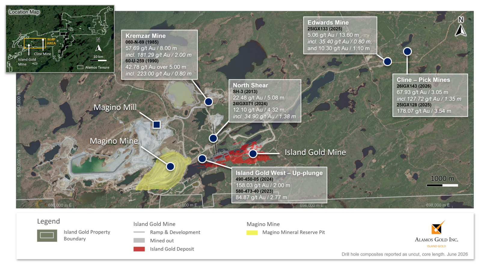
Figure 2: Island Gold Mine longitudinal (C-Zone & Hanging Wall Zones): new surface & underground exploration drilling highlights
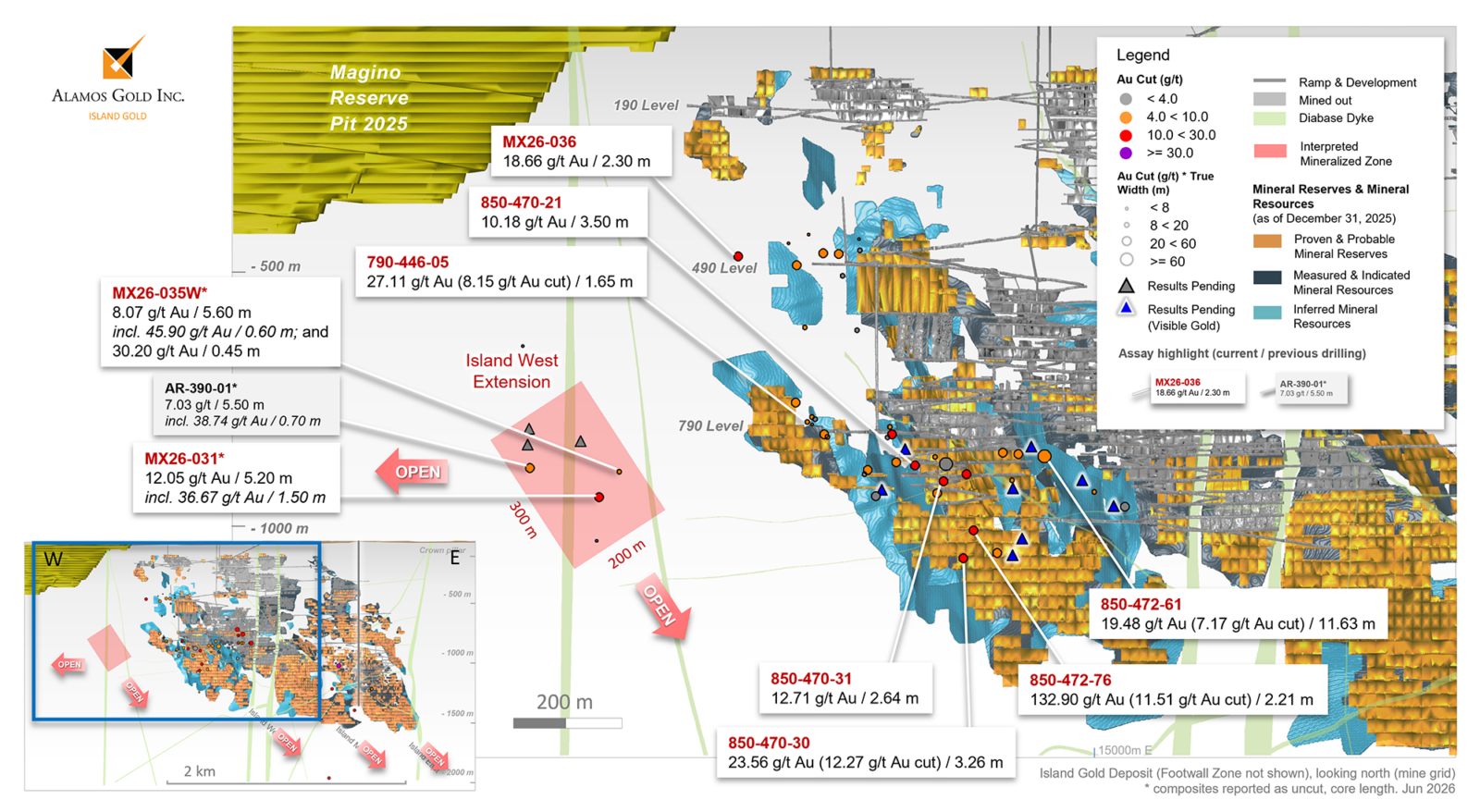
Figure 3: Location map – Island Gold District regional exploration – Cline-Pick & Edwards Mines
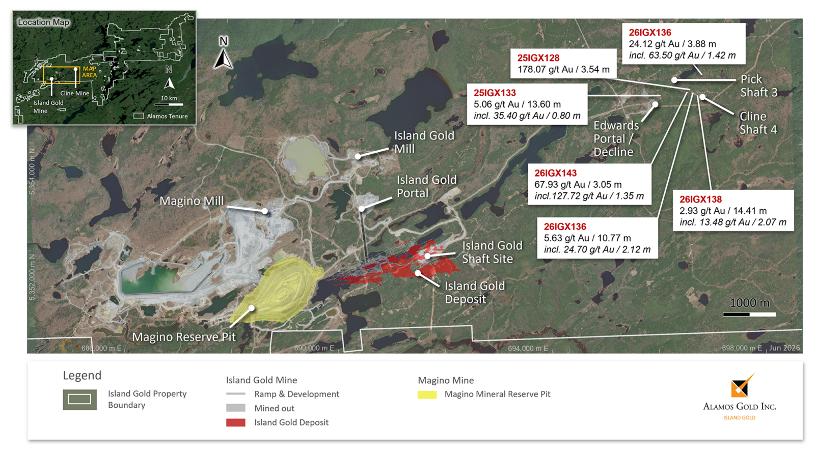
Figure 4: Island Gold District long section – Magino, Island Gold, & Cline-Pick & Edwards Mines with new exploration drilling highlights from Island West Extension & Cline-Pick
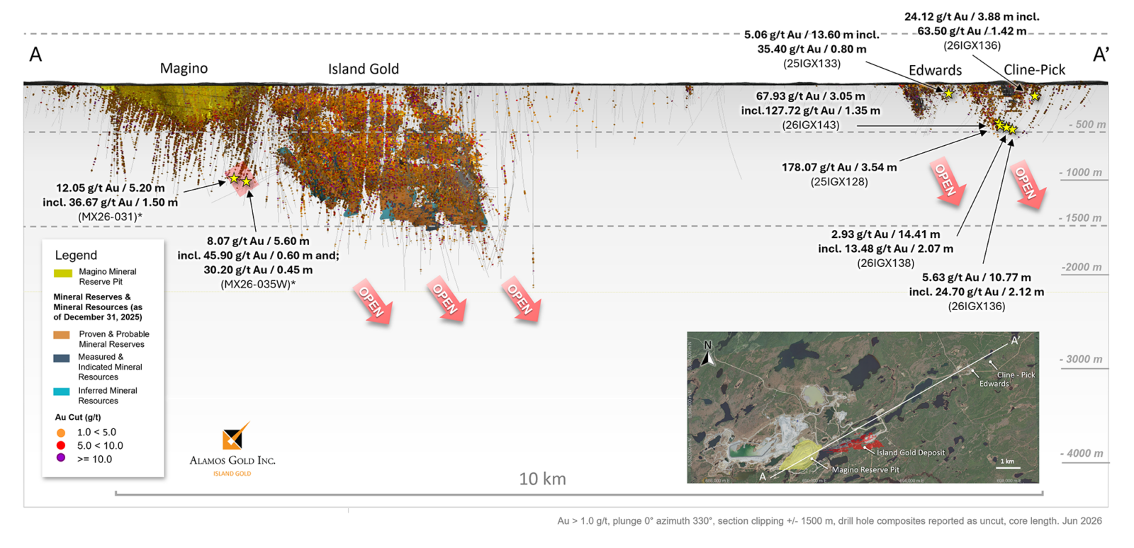
Figure 5: Cline-Pick Mines plan map with current & historic drilling A-A’ cross section reference (see Figure 6)
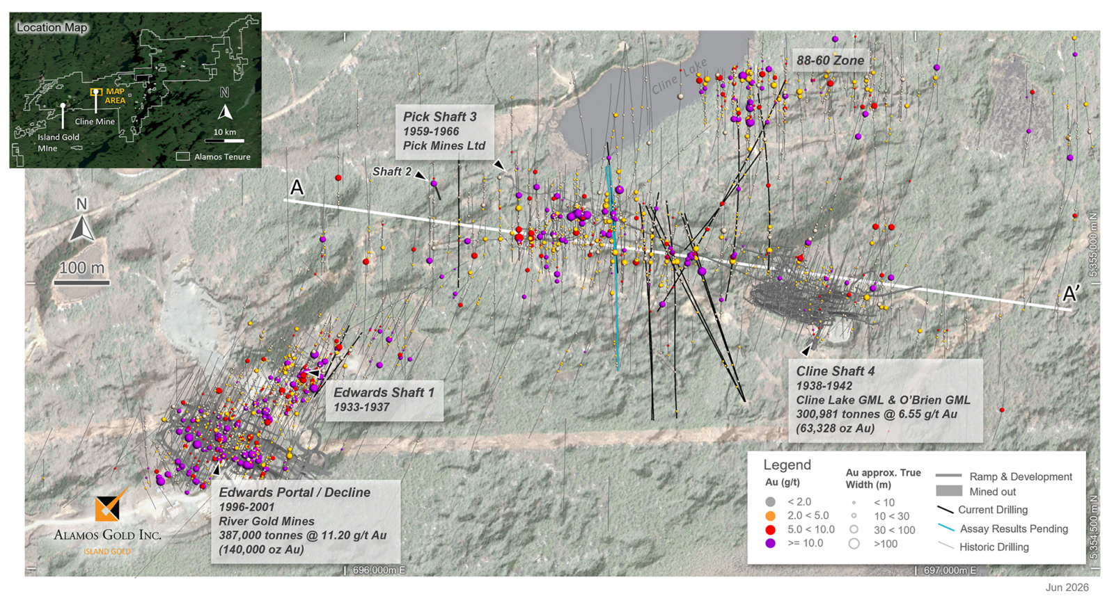
Figure 6: Cline- Pick Mines longitudinal with current & historic drilling
Imperial Metals Corporation (TSX:III) reports copper and gold p... READ MORE
Aldebaran Resources Inc. (TSX-V: ALDE) (OTCQX: ADBRF) and its maj... READ MORE
Nevada Sunrise Metals Corporation (TSX-V: NEV) (OTC Pink: NVSGF)... READ MORE
Newmont Corporation (NYSE: NEM) (ASX: NEM) (PNGX: NEM) announced ... READ MORE
Scorpio Gold Corporation (TSX-V: SGN) (OTCQB: SRCRF) (FSE: RY9) i... READ MORE


