








The Prospector News

AbraSilver Intersects Broad Zones of Near-Surface Gold Mineralization at Cerro Viejo Target on Diablillos Property

You have opened a direct link to the current edition PDF

Open PDF Close
Uncategorized

Share this news article

AbraSilver Intersects Broad Zones of Near-Surface Gold Mineralization at Cerro Viejo Target on Diablillos Property


Shallow Oxide-Hosted Gold Confirmed 4 km North of Oculto; Copper Intersected at Depth


AbraSilver Resource Corp. (TSX: ABRA) (OTCQX: ABBRF) is pleased to report new assay results from five holes completed at the Cerro Viejo target as part of the ongoing Phase VI exploration drill program at its wholly-owned Diablillos project in Argentina.


Cerro Viejo is located approximately 4 km north of the Oculto deposit, where surface channel sampling and earlier reconnaissance drilling identified gold mineralization associated with extensive east-west trending silicified structures extending for approximately 1.5 km. Initial reconnaissance drilling at Cerro Viejo conducted in 2024 returned 36.0 metres grading 1.91 g/t gold from a downhole depth of only 87 m in hole DDH 24-056, including 5.0 m grading 7.22 g/t gold (see the Company’s news release dated January 27, 2025). Follow-up drilling has now confirmed broad zones of shallow, oxide-hosted gold mineralization beginning close to surface, together with copper mineralization in sulphides at depth.


These results further highlight the exploration potential of the Diablillos property beyond the Mineral Resources and Mineral Reserves that underpin the recently completed Definitive Feasibility Study.


Highlight Drill Results: Widths are reported as drilled; true widths are not yet known.

  • DDH 26-037: 27.0 m of 0.58 g/t gold and 4.6 g/t silver from a downhole depth of only 23 metres, within the oxide zone
  • DDH 26-043: 7.0 m of 0.53% copper from a downhole depth of 97 m, confirming sulphide copper mineralization beneath the gold-bearing oxide zone
  • DDH 26-047: 32.0 m of 0.29 g/t gold and 2.8 g/t silver from a downhole depth of only 9 m, followed by 14.0 m of 1.50 g/t gold and 6.2 g/t silver from 54 m, both within the oxide zone
  • DDH 26-048: 21.0 m grading 0.12 g/t gold and 0.10% copper from a downhole depth of 82 m, and 18.0 m grading 0.13 g/t gold and 0.06% copper from 212 m


Table 1 – Summary of Key Drill Intercepts


Drill Hole Area From
(m)
To
(m)
Type Interval
(m)
Ag
(g/t)
Au
(g/t)
Cu
(%)
DDH-26-037 Cerro Viejo 23.0 50.0 Oxides 27.0 4.6 0.58
DDH-26-043 Cerro Viejo 97.0 104.0 Sulphides 7.0 0.53
112.0 117.0 Sulphides 5.0 0.15
187.0 190.0 Sulphides 3.0 12.5 0.17 0.57
DDH-26-046 Cerro Viejo 82.0 97.5 Sulphides 15.5 0.10
DDH-26-047 Cerro Viejo 9.0 41.0 Oxides 32.0 2.8 0.29
54.0 68.0 Oxides 14.0 6.2 1.50
DDH-26-048 Cerro Viejo 37.5 50.5 Sulphides 13.0 0.10
81.5 102.5 Sulphides 21.0 1.9 0.12 0.10
212.0 230.0 Sulphides 18.0 1.5 0.13 0.06


Note: All results in this news release are rounded. Assays are uncut & undiluted. Widths are drilled widths, not true widths. True widths are unknown


John Miniotis, President and CEO, commented, “These initial results from Cerro Viejo are encouraging, with broad zones of gold mineralization starting close to surface within the oxide zone. With the Diablillos DFS now complete and the Project advancing toward a construction decision, our exploration efforts have returned to unlocking the longer-term growth potential, and Cerro Viejo is emerging as an exciting target within the broader district.”


Dave O’Connor, Chief Geologist, commented, “What stands out from these results is the continuity of shallow gold mineralization, with mineralization beginning essentially at surface in several holes. The copper mineralization encountered beneath the oxide zone is also consistent with the upper levels of the larger porphyry system interpreted to underlie this area. Continued drilling will help us better define the scale and potential of this emerging target.”
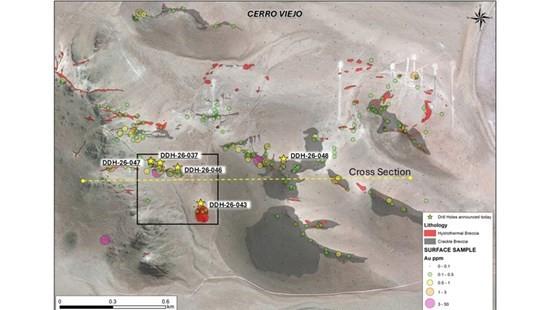
 

Figure 1 – Plan View of Cerro Viejo Drill Results & Surface Sample Results
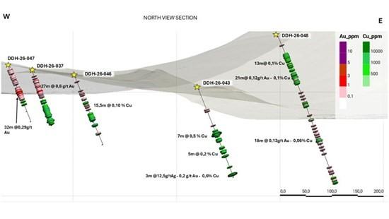
 

 Figure 2 – Cerro Viejo Cross-Section


Additional Details on Drill Results


Cerro Viejo is one of several new exploration areas being systematically tested within the Diablillos property and is located approximately 4 km north of the Oculto deposit. Gold mineralization at Cerro Viejo is hosted within extensive, east-west trending silicified structures that have been traced at surface within a band approximately 0.5 kilometres wide over a strike length of approximately 1.5 kilometres. The mineralization occurs in an epithermal environment interpreted to represent the upper levels of a major porphyry system.


Initial reconnaissance drilling at Cerro Viejo in 2024 intersected widespread gold mineralization, including 36.0 m grading 1.91 g/t gold from a downhole depth of only 87 m in hole DDH 24-056, with a higher-grade interval of 5.0 m grading 7.22 g/t gold. Surface chip and channel samples from the associated siliceous outcrops returned gold values including 16.36 g/t, 12.14 g/t, 3.2 g/t and 2.3 g/t gold. Together these results outlined a large zone with potential for shallow gold mineralization, which is the target of the current drill program. For further details, see the Company’s news release dated January 27, 2025.


The mineralized structures occur within zones of silicification in granitoid rocks that host the underlying porphyry system. The gold-bearing silicification includes areas of vuggy silica and brecciation with alunite-jarosite alteration and appears to be steeply dipping. Oxidation in the area is shallow, and preliminary mineralogical work indicates that gold associated with sulphides (pyrite) largely occurs as fine native metal. Metallurgical testwork has not been completed on mineralization from Cerro Viejo.


Cerro Viejo – Near-Surface Oxide Gold Zone (Holes DDH 26-037 and DDH 26-047)


Holes DDH 26-037 and DDH 26-047 both intersected broad zones of gold mineralization within the oxide zone from close to surface, with mineralization in hole DDH 26-047 commencing at a downhole depth of only 9 m. Oxidation across the area tested to date is shallow, and the mineralization intersected in these holes is oxide-hosted throughout.


Cerro Viejo – Copper Mineralization at Depth (Holes DDH 26-043 and DDH 26-048)


Copper values in holes DDH 26-043 and DDH 26-048 occur within sulphides below the oxide zone and are interpreted to represent the deeper parts of steeply dipping mineralized structures. Hole DDH 26-048 is located approximately 500 m northeast of hole DDH 26-043, indicating that mineralization of this style is developed across a substantial area of the property.


Phase VI Exploration Update:


A total of approximately 12,000 m have been completed in 54 diamond drill holes under the Phase VI exploration program since it commenced in January 2026, of which approximately 1,000 m have been drilled at Cerro Viejo. Two drill rigs remain active on the Project, and a third drill rig is expected to be mobilized later in September.


Drilling continues to test extensions of the known mineralization at Oculto West, Oculto East and along the JAC–Oculto trend, in parallel with first-pass and follow-up drilling on new targets including Cerro Viejo and the adjacent Condoryacu property, where initial drilling returned 72 m grading 18.7 g/t gold, 117 g/t silver and 2.06% copper from surface (see the Company’s news release dated March 30, 2026).


The Company has recently completed a drone-based magnetic survey at Condoryacu, which shows a distinct north-south character that may reflect structures controlling mineralization. The results will be used to guide follow-up drilling at Condoryacu, which is expected to commence shortly.


The Company is currently conducting a CSAMT survey across the broader Oculto and JAC areas and the intervening trend, with the objective of identifying additional drill targets for the balance of the Phase VI program and for future exploration. The survey comprises northwest-southeast lines, approximately perpendicular to the main structural trends of mineralization, covering an area of 3.5 km northeast-southwest by 2 km northwest-southeast. A historical CSAMT survey over the area showed a strong vertical contrast in resistivity, interpreted to reflect an alteration zone associated with the main feeder system to the Oculto mineralization.


Additional assay results from the ongoing Phase VI drill program are pending and will be released as they become available.


Collar Data


Hole Number UTM Coordinates Elevation Azimuth Dip Depth (m) Area
DDH 26-037 722233 7202291 4,192 180 -60 119 Cerro Viejo
DDH 26-043 722462 7202066 4,157 178 -60 194 Cerro Viejo
DDH 26-046 722328 7202269 4,176 180 -60 150 Cerro Viejo
DDH 26-047 722179 7202302 4,202 180 -60 122 Cerro Viejo
DDH 26-048 720171 7199283 4,254 180 -60 323 Cerro Viejo


About Diablillos


The Diablillos property is located within the Puna region of Argentina, in the southern part of Salta Province along the border with Catamarca Province, approximately 160 km southwest of the city of Salta and 375 km northwest of the city of Catamarca. AbraSilver acquired the property in 2016, which comprises 15 contiguous and overlapping mineral concessions with excellent year-round road access.


Exploration to date has outlined multiple occurrences of silver-gold oxide mineralization at Oculto, JAC, Laderas, and Fantasma, located within a 500 m to 1.5 km distance surrounding the Oculto/JAC epicentre. To date, over 170,000 metres have been drilled on the property, which continues to demonstrate the strong growth potential of shallow, oxide-hosted silver and gold resources. In addition, a large porphyry complex is centered approximately 4 km northeast of Oculto which includes outcropping porphyry intrusions within a major zone of alteration and associated gold rich epithermal mineralization.


Comparatively nearby examples of high sulphidation epithermal deposits include: La Coipa (Chile); Yanacocha (Peru); El Indio (Chile); Lagunas Nortes/Alto Chicama (Peru) Veladero (Argentina); and Filo del Sol (Argentina). The most recent tank and heap leach Mineral Resource estimate for Diablillos is shown in Table 2. Following completion of the DFS in June 2026, the Project also hosts Proven and Probable Mineral Reserves of 77.9 Mt grading 146 g/t silver equivalent, containing 184 Moz of silver and 1.8 Moz of gold (366 Moz AgEq). For additional details, please refer to the “NI 43-101 Mineral Resource Estimate, Diablillos Silver-Gold Project” dated June 19, 2026, available on SEDAR+ and the Company’s website.


Table 2 – Diablillos Mineral Resource Estimate – As of April 30, 2026


Zone Category Tonnes
(000 t)
Ag
(g/t)
Au
(g/t)
AgEq
(g/t)
Contained
Ag

(000 Oz)
Contained
Au

(000 Oz )
Contained
AgEq

(000 Oz)
 
Tank
Leach
Oxides Measured 41,042 100 0.68 159 131,668 896 209,281  
Indicated 60,978 41 0.58 92 81,060 1,143 180,078  
Measured & 102,021 65 0.62 119 212,728 2,039 389,359  
Indicated                
Inferred 14,400 25 0.57 74 11,468 262 34,187  
Heap
Leach
Oxides Measured 25,469 13 0.09 19 10,997 76 15,425  
Indicated 104,491 7 0.13 15 24,328 428 49,342  
Measured & 129,960 8 0.12 16 35,325 503 64,767  
Indicated  
Inferred 34,947 6 0.14 14 6,939 158 16,153  
Total Oxides Measured 66,512 67 0.45 105 142,665 971 224,706  
Indicated 165,469 20 0.30 43 105,388 1,570 229,420  
Measured & 231,981 33 0.34 61 248,053 2,542 454,127  
Indicated  
Inferred 49,347 12 0.26 32 18,406 420 50,340  


  • Footnotes for Tank Leach Resource:
  1. Mineral Resources are not Mineral Reserves and have not demonstrated economic viability.
  2. The formula for calculating AgEq is as follows: Silver Eq Oz = Silver Oz + Gold Oz x (Gold Price/Silver Price) x (Gold Recovery/Silver Recovery).
  3. The Mineral Resource model was populated using Ordinary Kriging grade estimation within a three-dimensional block model and mineralized zones defined by wireframed solids, which are a combination of lithology and alteration domains. The 1m composite grades were capped where appropriate.
  4. The Mineral Resource is reported inside a conceptual Whittle open pit shell derived using US$ 34.50/oz Ag price, US $3,200/oz Au price, 86.6% process recovery for Au, and 80.9% process recovery for Ag, for the tank leaching and 74.3% process recovery for Au, and 46.8% process recovery for Ag, for the secondary heap leaching.
  5. Open pit optimization was constrained using a dual-process approach, with tank leaching as the primary process (total opex of US$32.30/t) and heap leaching as the secondary process (total opex of US$7.00/t).
  6. The MRE has been categorized in accordance with the CIM Definition Standards (CIM, 2014).
  7. A Net Value per block [NVB] calculation was used to constrain the Mineral Resource, determine the “Benefits = Income-Cost”, where, Income = [(Au Selling Price (US$/oz) – Au Selling Cost (USD/Oz)) x (Au grade (g/t)/31.1035)) x Au Recovery (%)] + [(Ag Selling Price (US$/oz) – Ag Selling Cost (USD/Oz)) x (Ag grade (g/t)/31.1035)) x Ag Recovery (%)] and Cost = Mining Cost (US$/t) + Process Cost (US$/t) + Transport Cost (US$/t) + G&A Cost (US$/t) + [Royalty Cost (%) x Income]
  8. The Mineral Resource is sub-horizontal with sub-vertical feeders and has a reasonable prospect for eventual economic extraction by open pit methods.
  9. In-situ bulk densities were assigned to each model domain, according to samples averages for each lithology domain, separated by alteration zones and subset by oxidation.
  10. All tonnages reported are dry metric tonnes and ounces of contained gold are troy ounces.
  11. Mining recovery and dilution factors have not been applied to the Mineral Resource estimates.
  12. The Mineral Resource was estimated by Luis Rodrigo Peralta, B.Sc., FAusIMM CP (Geo), an INSA Consultora Managing Principal Geologist, and an Independent Qualified Person under NI 43-101.
  13. Mr. Peralta is not aware of any environmental, permitting, legal, title, taxation, socio-political, marketing, or other relevant issues that could materially affect the potential development of the Mineral Resource.
  14. All figures are rounded to reflect the relative accuracy of the estimates. Minor discrepancies may occur due to rounding to appropriate significant figures.
  • Footnotes for Heap Leach Resource:
  1. Mineral Resources are not Mineral Reserves and have not demonstrated economic viability.
  2. The formula for calculating AgEq is as follows: Silver Eq Oz = Silver Oz + Gold Oz x (Gold Price/Silver Price) x (Gold Recovery/Silver Recovery).
  3. The Mineral Resource model was populated using Ordinary Kriging grade estimation within a three-dimensional block model and mineralized zones defined by wireframed solids, which are a combination of lithology and alteration domains. The 1m composite grades were capped where appropriate.
  4. The Mineral Resource is reported inside a conceptual Whittle open pit shell derived using US$ 34.50/oz Ag price, US $3,200/oz Au price, 86.6% process recovery for Au, and 80.9% process recovery for Ag, for the primary process tank leaching and 74.3% process recovery for Au, and 46.8% process recovery for Ag, for the secondary process heap leaching.
  5. Open pit optimization was constrained using a dual-process approach, with tank leaching as the primary process (total opex of US$32.30/t) and heap leaching as the secondary process (total opex of US$7.00/t).
  6. The MRE has been categorized in accordance with the CIM Definition Standards (CIM, 2014).
  7. A Net Value per block [NVB] calculation was used to constrain the Mineral Resource, determine the “Benefits = Income-Cost”, where, Income = [(Au Selling Price (US$/oz) – Au Selling Cost (USD/Oz)) x (Au grade (g/t)/31.1035)) x Au Recovery (%)] + [(Ag Selling Price (US$/oz) – Ag Selling Cost (USD/Oz)) x (Ag grade (g/t)/31.1035)) x Ag Recovery (%)] and Cost = Mining Cost (US$/t) + Process Cost (US$/t) + Transport Cost (US$/t) + G&A Cost (US$/t) + [Royalty Cost (%) x Income].
  8. The Mineral Resource is sub-horizontal with sub-vertical feeders and a reasonable prospect for eventual economic extraction by open pit methods.
  9. In-situ bulk density was assigned to each model domain, according to samples averages for each lithology domain, separated by alteration zones and subset by oxidation.
  10. All tonnages reported are dry metric tonnes and ounces of contained gold are troy ounces.
  11. Mining recovery and dilution factors have not been applied to the Mineral Resource estimates.
  12. The Mineral Resource was estimated by Luis Rodrigo Peralta, B.Sc., FAusIMM CP (Geo), an INSA Consultora Managing Principal Geologist, and an Independent Qualified Person under NI 43-101.
  13. Mr. Peralta is not aware of any environmental, permitting, legal, title, taxation, socio-political, marketing, or other relevant issues that could materially affect the potential development of the Mineral Resource.
  14. All figures are rounded to reflect the relative accuracy of the estimates. Minor discrepancies may occur due to rounding to appropriate significant figures.


QA/QC and Core Sampling Protocols


AbraSilver applies industry standard exploration methodologies and techniques, and all drill core samples are collected under the supervision of the Company’s geologists in accordance with industry best practices. Drill core is transported from the drill platform to the logging facility where drill data is compared and verified with the core in the trays. Thereafter, it is logged, photographed, and split by diamond saw prior to being sampled. Samples are then bagged, and quality control materials are inserted at regular intervals at site; these include blanks and certified reference materials as well as duplicate core samples which are collected in order to assess sampling precision and reproducibility. Groups of samples are then placed in large bags which are sealed with numbered tags in order to maintain a chain-of-custody during the transport of the samples from the project site to the laboratory.


All samples are received by the ASA (Alex Stewart Argentina) preparation laboratory in Salta, where they are prepared, then the pulp sachet is directly dispatched to its facility in Mendoza, Argentina, where they are analyzed. All samples are analyzed using a multi-element technique consisting of a four-acid digestion followed by ICP/AES detection, and gold is analyzed by 50g Fire Assay with an AAS finish. Silver results greater than 100g/t are re-analyzed using four acid digestion with an ore grade AAS finish.


Qualified Persons


David O’Connor P.Geo., Chief Geologist for AbraSilver, is the Qualified Person as defined by National Instrument 43-101 Standards of Disclosure for Mineral Projects, and he has reviewed and approved the scientific and technical information in this news release.


About AbraSilver


AbraSilver is a leading silver-gold development company focused on advancing its 100%-owned Diablillos Project in the mining-friendly provinces of Salta and Catamarca, Argentina. The recently completed Definitive Feasibility Study highlights Diablillos as a robust, high-margin, long-life precious metals project with a strong production profile and substantial exploration upside. In addition, the Company has entered into an earn-in option and joint venture agreement with Teck on the La Coipita project, located in the San Juan province of Argentina.


Posted September 2, 2026

Share this news article

MORE or "UNCATEGORIZED"


Critical Metals Corp Achieves Breakthrough Tanbreez Heavy Rare Earth Results: >99% Dissolution of Eudialyte Concentrate Into 19 Ultra-High-Purity Rare Earth Products; Refinery Study Projects US$1.8–2.2b in Annual Refinery Revenue

Critical Metals Corp. (Nasdaq: CRML) a leading critical minerals ... READ MORE

September 16, 2026

Metalsource Mining Extends High Grade Mineralization at Depth as Silver Hill Exploration Enters Major Expansion Phase

Holes SH26-22 and SH26-23 return up to 930 g/t AgEq within broade... READ MORE

September 16, 2026

Pasinex Completes Sale of High-Grade Zinc Sulphide Material and Provides Pinargozu Operations Update

Pasinex Resources Limited (CSE: PSE) (FSE: PNX) a growing zinc-fo... READ MORE

September 16, 2026

Aya Gold & Silver Reports High-Grade Silver Exploration Results Near Pit and at Depth at Zgounder

Aya Gold & Silver Inc. (TSX: AYA; NASDAQ: AYA) is pleased to... READ MORE

September 16, 2026

New Break Resources Ltd. (CSE: NBRK) (OTCQB: NBRKF) (FSE: O91) has received results from the last four holes of a ten-hole, 1,996 metre summer drilling program in the Zavitz gold zone at the Company's 100% owned Moray gold project. In total, New Break has completed 5,372 metres of drilling in 32 drillholes in 2026. Moray is located 49 km southeast of Timmins, Ontario and 32 km northwest of the Young-Davidson gold mine operated by Alamos Gold Inc. Select results from the final four of ten holes drilled in the summer drilling program are presented below in Table 1, while drillhole collar locations are detailed in Table 2 in Appendix A. Table 1 – Moray Summer 2026 Final Drill Results Hole ID Length (m) From (m) To (m) Width (1) (m) Au Grade (2) (g/t) NBR-26-29 322.0 77.3 78.8 1.5 0.42 and 138.0 139.1 1.1 0.38 and 162.5 173.3 10.8 (3) 1.61 and 227.4 229.0 1.6 1.21 and 231.5 232.1 0.6 1.72 NBR-26-30 250.0 37.0 38.0 1.0 0.30 and 102.8 103.5 0.7 0.60 and 121.5 122.5 1.0 0.36 and 124.5 125.5 1.0 0.33 and 128.5 129.0 0.5 0.90 and 131.0 132.0 1.0 0.36 and 169.8 174.0 4.2 2.65 and 178.0 179.5 1.5 0.77 and 183.5 186.6 3.1 1.22 and 190.0 190.5 0.5 1.06 and 191.5 192.5 1.0 1.48 and 196.0 200.5 4.5 2.53 and 203.5 204.0 0.5 2.15 and 206.5 212.0 5.5 1.57 NBR-26-31 274.0 169.0 170.5 1.5 0.37 and 184.5 186.0 1.5 0.51 and 197.0 200.0 3.0 0.94 and 201.5 202.0 0.5 0.50 and 203.5 210.0 6.5 (3) 3.12 NBR-26-32 352.0 73.5 74.0 0.5 0.44 and 174.0 174.6 0.6 0.52 and 194.0 195.0 1.0 0.66 and 199.8 203.3 3.5 2.29 and 227.3 228.0 0.7 0.97 (1) Intervals are drill intersections and do not necessarily represent true widths. (2) All intervals are presented using a cut-off grade of 0.3 g/t Au and internal dilution of no more than 1.0 metres at grades less than 0.3 g/t Au and assays are not capped (see QA/QC Procedures). (3) Drill core photos shown in Appendix B. Figure 1 – Newly Reported Drillholes NBR-26-29, 30 Figure 2 – Newly Reported Drillholes NBR-26-30, 31, 32 Note: The bottom of NBR-26-30 deviated southeast and is represented in both sections. Figure 1: Section B-B1 incorporates drillholes NBR-26-06, 07, 08, 25, 26, 27, 28, 29 and part of 30. Gold mineralization extends southeast into the syenite as exhibited in NBR-26-29. NBR-26-30 is identified in both sections A-A1 and B-B1 as the drillhole was collared along section A-A1 but deviated southeast, intersecting gold mineralization in the mafic volcanics in section B-B1. Figure 2: A-A1 incorporates drillholes NBR-26-03, 04, 05, 23, 24, 30, 31 and 32. NBR-26-31 exhibits gold mineralization both within the syenite (at the contact) and within a "flow breccia" within the hematite altered mafic volcanic at the contact. NBR-26-32 is typified by blocky faulted ground with lamprophyre dykes and gold mineralization in the hematite altered mafic volcanics in a brecciated quartz vein with angular syenitic fragments. William Love, Chief Executive Officer of New Break commented, "Ongoing drilling this summer in the Zavitz gold zone continues to deliver significant gold values, with gold mineralization intercepted in every drillhole. As depicted in Figures 1 and 2, gold mineralization has been encountered predominantly within the mafic volcanics. Importantly, drillholes NR-26-29 and NR-26-32, the deepest drilled to date, demonstrate that gold mineralization extends into the syenite to the southeast at the contact with the mafic volcanics." He further noted, "The intrusive-mafic volcanic contact in the Zavitz gold zone has a distinctive magnetic high. This could be reflective of the higher proportion of iron in these mafic volcanics, which is associated with the higher gold values. This same magnetic and IP signature has been identified elsewhere in areas also believed to be along the intrusive-mafic volcanic contact. Drilling these never before tested targets with the goal of identifying gold mineralization similar to that encountered in the Zavitz zone represents the potential for significantly expanding the Moray gold discovery. There is also the belief that the Zavitz zone could represent the first of a series of stacked mineralized gold zones, which would point to the potential for a much larger gold system at depth. We plan to test this through deeper drilling directly into the Zavitz zone." About the Moray Gold Project The Moray property is located in the heart of the Ontario Abitibi greenstone belt, 49 km southeast of Timmins surrounded by a number of significant gold producing companies and existing mills (see Figure 3). The Young-Davidson gold mine operated by Alamos Gold Inc., with its 8,000 tonne per day mill is the closest and within a short trucking distance of approximately 45 km by road from Moray. The understanding of gold mineralization at Moray continues to evolve with each round of drilling. The occurrence of gold mineralization extending into the syenite to the southeast of the Zavitz zone and in the deepest drillholes is noteworthy given the presence of syenite-hosted mineralization at Young-Davidison. More recent examination of the drill core also suggests that the gold mineralization discovered to date may resemble an intrusion related style of deposit like Agnico Eagle's Upper Beaver gold deposit east of Kirkland Lake, as opposed to a structurally hosted gold system. Both Young-Davidson and Upper Beaver host multi-million ounce gold deposits. Figure 3 – Moray Location Map: Surrounding Gold Producers and Upper Beaver Gold Project Technical Content and Qualified Person The scientific and technical information contained in this news release has been reviewed and approved by Peter C. Hubacheck, P. Geo, consulting geologist to New Break, and an independent Qualified Person as defined by National Instrument 43-101. Mr. Hubacheck certifies that this news release fairly and accurately reflects the technical information and data presented. New Break conducts its exploration activities in accordance with CIM Best Practices Guidelines. QA/QC Procedures QA/QC procedures were executed to ensure all work is conducted in accordance with best practices. All drill core was sawn in half with one half of the core prepared for shipment and the other half retained for future verification. All core is under watch from the drill site to the core processing facility. Drill core is BQTK size and sample intervals range from 0.5 metres to 1.0 metres in length. Commercially prepared certified reference material ("CRM") standards and blanks were inserted with each shipment at a rate of 1 QAQC sample in every 12 core samples. Samples from New Break's 2026 Moray drilling program were analyzed at Activation Laboratories in Timmins, Ontario, which is ISO 17025 certified, by 30-gram fire assay with atomic absorption finish. Any sample assaying greater than 10.0 g/t Au was re-assayed with fire assay gravimetric analysis. Grade composite intervals over core lengths are calculated using a weighted average grade with a cut-off grade of 0.3 g/t Au. Up to 1.0 m of internal dilution (consecutive interval below cut-off grade) are included within specific geologic domains and alteration assemblages, except as otherwise noted. The composites are constrained geologically by metasomatic alteration processes sourcing from the Fiset syenite intrusion and contact mafic volcanic rocks. Elevated gold values are coincident with hematite, silica, sericite and pyrite mineralization within structurally prepared brecciated corridors flanking the intrusion. Intervals are not true widths and no top cutting has been applied to the higher gold values. About New Break Resources Ltd. New Break is a Canadian mineral exploration company focused on its Moray gold project located 49 km southeast of Timmins, Ontario, in a well-established mining camp within proximity to existing infrastructure, and 32 km northwest of the Young-Davidson gold mine, operated by Alamos Gold Inc. Shareholders are also leveraged to exploration success in Nunavut, Canada, through New Break's 20% carried interest in the Sundog gold project and ownership of 6.0 million shares of Guardian Exploration Inc. (TSXV: GX). The Company is supported by a highly experienced team of mining professionals. Appendix A – Drillhole Data and Locations Table 2 – Moray Summer 2026 Drillhole Collar Locations Hole ID Length (m) UTM Easting UTM Northing UTM Elevation Azimuth (degrees) Dip (degrees) NBR-26-29 322.0 492703 5320285 363 220 -70 NBR-26-30 250.0 492708 5320329 363 220 -47 NBR-26-31 274.0 492708 5320329 363 220 -60 NBR-26-32 352.0 492708 5320329 363 220 -70 Total 1,198.0 Coordinates are reported in UTM Zone 17 North, with units in metres. Figure 4 – Zavitz Gold Zone – Surface Traces of 2025 and 2026 Drillholes. All of the drilling at Moray has been completed by Enviro North Exploration Inc. out of Sturgeon Falls, Ontario. Drilling in the Zavitz gold zone is shown in figure 4, with the 1,996 metres in 10 holes drilled this summer depicted in red, the 2,807 metres in 20 holes drilled from January to April 2026 shown in blue and the 1,817 metres in 8 holes drilled in 2025 shown in black. In total, 6,620 metres in 38 drillholes have been completed in the Zavitz gold zone, while New Break has completed a total of 5,372 metres in 32 drillholes of our planned 2026, 10,000 metre drilling program. Appendix B – Drill Core Photos From NBR-26-29 and NBR-26-31

New Break Resources Ltd. (CSE: NBRK) (OTCQB: NBRKF) (FSE: O91) ha... READ MORE

September 16, 2026

Copyright 2026 The Prospector News
