








Legacy Gold Mines Ltd. (TSX-V: LEGY) is pleased to report assay results from two (2) core holes and two (2) RC holes from its 2026 drill program at the Baner Gold Mine Property in Idaho County, Idaho, USA, and to announce that it is advancing geological, metallurgical and other technical work toward an initial mineral resource estimate for the Baner Property.
“The Main Zone is now over 3,500 feet (more than 1 kilometre) long, and the mineralization there and now in the NE Zone is still open in all directions and is following our interpreted orientations,” said Mike Sutton, a Director and VP Exploration for Legacy Gold. “Our first-ever hole in the NW Zone hit gold nearly 4,000 feet (1.2 kilometres) from the closest Main Zone drilling, with gold in soils suggesting the mineralization continues. While our priority remains completing the work to deliver an initial mineral resource, the NW Zone is now a significant new target for follow-up.”
“Alongside the plans for the winterized drill to return to site, engineering and technical work on the geologic and metallurgical fronts is underway toward Baner’s initial mineral resource,” said Brian Hinchcliffe, Executive Chairman and CEO of Legacy Gold. “The Company’s recently announced financing is expected to close in the coming weeks, funding the exciting 2027 step-out exploration plans and additional engineering and technical studies at the Baner Property, as well as a broader focus on opportunities in the historic Elk City gold mining district.”
These results show:
Drilling Highlights
LG26-049:
LG26-052:
LG26-001:
LG26-012A:
Note: intersections less than the 0.2 g/t lower cut-off are shown to indicate anomalous zones close to the cut-off.
See Table 1: 2026 Baner Drill Program -Assay Results and Table 2: Drill Hole Coordinates, below, and Figures 1 to 4.
LG26-049 and LG26-052
There are historical pits and trenches, along with a historical mine (the Zenith Mine), located up to 130m (426.5ft) to the north of holes LG26-049 and LG26-052. One core hole, LG26-010, was drilled towards the NW Zone in an area 170m (558ft) west and up-hill from previously-released hole LG25-006, which returned 0.57 g/t Au over 64.0m (210ft) beginning at surface.
LG26-001
The mineralization in LG26-001 is highly oxidized, but up to 3% pyrite is present, associated with quartz veins, sericite and silicification in granodiorite plus biotite schist. Eleven other anomalous zones were encountered in this hole, returning assays between 0.04 g/t and 0.11 g/t Au.
The NW Zone is located NW of the Main Zone, with hole LG26-001 approximately 1,200m (3,940ft) from the closest Main Zone drilling and the gold-in-soil anomaly extending a further 500m (1,640ft) beyond the hole, along similar geophysical and geochemical anomalies as the Main Zone. Similar magnetic highs, IP conductors and high gold-in-soil anomalies (up to 1.0 g/t gold) are located along this NW trend, as are found at the Main Zone, yet it had never been drilled until hole LG26-001. The closest drill hole is previously-released Main Zone step-out hole LG26-005, which extended Main Zone gold mineralization 220m (720ft) north of the nearest previous drill intersection.
Another zone, tested by core hole LG26-002 (assays pending), is located to the west of the NW Zone and is identified by a 530m (1,739ft) long north-south soil anomaly with a high of 1.1 g/t gold.
2026 Drill Program
The 2026 drill program was designed to begin with up to 12,000ft (3,658m) of core drilling in Phase 1, followed by up to 28,000ft (8,536m) of RC drilling in Phase 2. This program follows up on the successful 2025 results by targeting both the Main and Northeast Zones, as well as new exploration targets to the northwest indicated by large gold-in-soil anomalies coincident with geophysical conductors and similar magnetic highs as are in the Main Zone.
To date, eleven core holes have been drilled: one exploration hole to the west; two (2) holes at the south end of the Main Zone and Baner Zones; three holes up the hill in the western portion of the Main Zone; three holes at the north end of the Main Zone; and two (2) holes in Northeast Zone. The RC phase of the 2026 program is planned to comprise up to 53 holes, with 38 completed (3 of which were redrills and one was a twin). Altogether, approximately 32,000 feet of drilling has been completed.
The drill rig has been demobilized from site for winterization, and the Company currently intends to return it to site to resume drilling as part of its work toward an initial mineral resource. Assay results for a number of holes remain pending and will be released once received and reviewed.
Geology and Mineralization
The belt of mineralization that traces through the Elk City and Orogrande mining districts is known as the Orogrande Shear Zone, and is estimated to be between 100-200m wide, with a general NNE trend. Gold mineralization occurs along this zone in numerous prospects and small historic mines. Most of the mineralization appears to be along Riedel shear structures that cross over between two bounding major north-south structures along the Orogrande Shear Zone. In general, higher grade historical mining was undertaken on narrow zones of strong sericite-silica-carbonate alteration and quartz veins. Intrusion-related structurally controlled mineralization has been suggested previously. At the Property, the predominant host rock is quartzite, with some biotite gneiss also present.
Table 1: 2026 Baner Drill Program – Core and RC Assay Results
| Hole ID | From | To | Intercept | From | To | Intercept | Au | ||||||||||||||||||||||
| (m) | (m) | (m) | (ft) | (ft) | (ft) | (g/t) | |||||||||||||||||||||||
| LG26-001 | 62.8 | 71.65 | 8.85 | 206.0 | 235.1 | 29.0 | 0.37 | ||||||||||||||||||||||
| including | 66.2 | 66.5 | 0.3 | 217.2 | 218.2 | 1.0 | 1.5 | ||||||||||||||||||||||
| LG26-049 | 4.6 | 25.9 | 21.3 | 15 | 85 | 70 | 0.38 | ||||||||||||||||||||||
| including | 21.3 | 22.9 | 1.5 | 70 | 75 | 5 | 1.01 | ||||||||||||||||||||||
| 30.5 | 32.0 | 1.5 | 100 | 105 | 5 | 0.17 | |||||||||||||||||||||||
| 35.1 | 36.6 | 1.5 | 115 | 120 | 5 | 0.20 | |||||||||||||||||||||||
| 42.7 | 44.2 | 1.5 | 140 | 145 | 5 | 0.31 | |||||||||||||||||||||||
| 59.4 | 61.0 | 1.5 | 195 | 200 | 5 | 0.24 | |||||||||||||||||||||||
| 64.0 | 65.5 | 1.5 | 210 | 215 | 5 | 0.25 | |||||||||||||||||||||||
| LG26-052 | 6.1 | 7.6 | 1.5 | 20 | 25 | 5 | 0.20 | ||||||||||||||||||||||
| 9.1 | 10.7 | 1.5 | 30 | 35 | 5 | 0.57 | |||||||||||||||||||||||
| 21.3 | 22.9 | 1.5 | 70 | 75 | 5 | 0.20 | |||||||||||||||||||||||
| 25.9 | 29.0 | 3.0 | 85 | 95 | 10 | 0.17 | |||||||||||||||||||||||
| 30.5 | 71.6 | 41.1 | 100 | 235 | 135 | 0.35 | |||||||||||||||||||||||
| including | 30.5 | 32.0 | 1.5 | 100 | 105 | 5 | 1.07 | ||||||||||||||||||||||
| including | 61.0 | 62.5 | 1.5 | 200 | 205 | 5 | 1.63 | ||||||||||||||||||||||
| 97.5 | 99.1 | 1.5 | 320 | 325 | 5 | 0.17 | |||||||||||||||||||||||
| 163.1 | 166.1 | 3.0 | 535 | 545 | 10 | 0.22 | |||||||||||||||||||||||
| LG26-012A | 9.55 | 10.7 | 1.15 | 31.3 | 35.1 | 3.8 | 0. | ||||||||||||||||||||||
| 3 | 20 | ||||||||||||||||||||||||||||
| .2 | 21.7 | 1.5 | 66.3 | 71.2 | 4.9 | 0.53 | |||||||||||||||||||||||
| 49.3 | 73.2 | 23.9 | 161.7 | 240.2 | 78.4 | 0.17 | |||||||||||||||||||||||
| including | 49.9 | 51.2 | 1.3 | 163.7 | 168.0 | 4.3 | 0.58 | ||||||||||||||||||||||
| 86.9 | 88.3 | 1.4 | 285.1 | 289.7 | 4.6 | 0.24 | |||||||||||||||||||||||
| 89.8 | 91.3 | 1.5 | 294.6 | 299.5 | 4.9 | 0.16 | |||||||||||||||||||||||
| 97.4 | 103.9 | 6.5 | 319.5 | 340.9 | 21.3 | 0.51 | |||||||||||||||||||||||
| 164.3 | 164.9 | 0.6 | 539.0 | 541.0 | 2.0 | 0.37 | |||||||||||||||||||||||
| 174 | 192.2 | 18.2 | 570.9 | 630.6 | 59. | .19 | |||||||||||||||||||||||
| including | 177 | 178.2 | 1.2 | 580.7 | 584.6 | 3.9 | 0.47 | ||||||||||||||||||||||
| 192.2 | 193.5 | 1.3 | 630.6 | 634.8 | 4.3 | 0.17 | |||||||||||||||||||||||
| 322.5 | 324.2 | 1.7 | 1058.1 | 1063.6 | 5.6 | 0.15 |
Notes: Composite intersections are calculated using a 0.2 g/t cutoff for gold with 10m internal dilution. True widths are unknown until zone dips are proven. Intersections less than the 0.2 g/t lower cut-off are shown to indicate anomalous zones close to the cut-off.
Table 2: Drill Hole Coordinates
| Hole ID | Azimuth | Dip | Northing | Easting | Total Depth (m) | Total Depth (ft) |
| LG26-001 | 227 | -45 | 5071046 | 614497 | 189.3 | 621.1 |
| LG26-012A | 289.6 | -44 | 5070278 | 615600 | 352 | 1154.8 |
| LG26-049 | 286.6 | -44 | 5070145 | 615308 | 201 | 659.4 |
| LG26-052 | 318.7 | -40 | 5070145 | 615308 | 100.6 | 330.0 |
Review by Qualified Person, Quality Control and Data Verification
Mr. Mike Sutton, P.Geo., Director and VP of Exploration of the Company, is the Qualified Person, as defined under National Instrument 43-101 – Standards of Disclosure for Mineral Projects, who reviewed and approved scientific and technical disclosure in this press release. The Qualified Person has not reviewed the mineral tenure, nor independently verified the legal status and ownership of the Baner Property or any underlying property agreements.
RC Drilling/Lab
RC drilling is by Earth Drilling (Harris Drilling) which uses a hammer and at depth below groundwater level a tricone bit is sometimes used. RC drilling was done wet, with water actively pumped down the hole, mixing with pulverized sample, and coming through the cyclone to an 8-compartment rotary fan wet splitter. The sample is taken continuously and sent through a sample splitter with a second splitter on the outlet so that two bags are filled simultaneously. Each assay sample is for a 1.52m (5ft) interval. The bags are labeled with the Legacy hole number and a footage that is the interval which they are taken from. At the end of each ten foot run the drill pipe and the splitter are cleaned or if there is an observed color change in the rock coming up, it is cleaned. Chips were collected from the splitter reject and put into chip trays for reference. Bags are stored on the pad until the hole is finished, and then brought to the laydown yard for sorting and packaging to go to the assay lab. Skyline Assayers & Laboratories is a long-standing, independent laboratory at 7960 South Kolb Road, Tucson, Arizona, specializing in assaying and testing for the mining industry, with a history dating back to the 1880s. They are accredited to ISO 9001 and ISO 17025 standards.
Core Drilling/Lab
Core is sent to the Scout Drilling LLC prep-lab in Coeur d’Alene, Idaho, USA where it is split, with half core being crushed to appropriate size for shipment to the Paragon Geochemical lab in Reno, Nevada. All core samples are sealed at the core processing facility and shipped directly to the lab. All samples are assayed for gold by PhotonAssay methods. The lab has ISO/IEC 17025:2017 accreditation. The Company’s QA/QC program includes the regular insertion of blanks and standards into the sample shipments. Duplicates were prepared on-site (Scout) with a riffle splitter. Standards, blanks and duplicates are inserted at approximately one per 15 samples. Referee sampling will be done for 5% of samples at various grade increments (and including all higher-grade assays) by fire assay at a second lab.
About Legacy Gold Mines Ltd.
The Company is a Canadian-based gold exploration and development company listed on the TSX Venture Exchange under the symbol “LEGY”. The Company holds an option to acquire a 100% undivided interest in the mineral claims comprising the Baner Gold Mine Property located in Idaho County, Idaho, USA.
The Baner Gold Mine Property sits within the historic Orogrande Gold Mining District that hosts numerous gold deposits and gold mines along geologic structures that have hosted gold production since Idaho’s first gold rush in the late 1800s.
Additional information about the Company and the Baner Property is available on SEDAR+ at www.sedarplus.ca under the Company’s profile, including a technical report titled “NI 43-101 Technical Report on the Baner Project, Idaho County, Idaho, USA”, dated effective August 1, 2024, prepared by Steven A. Osterberg, Ph.D., P.G.
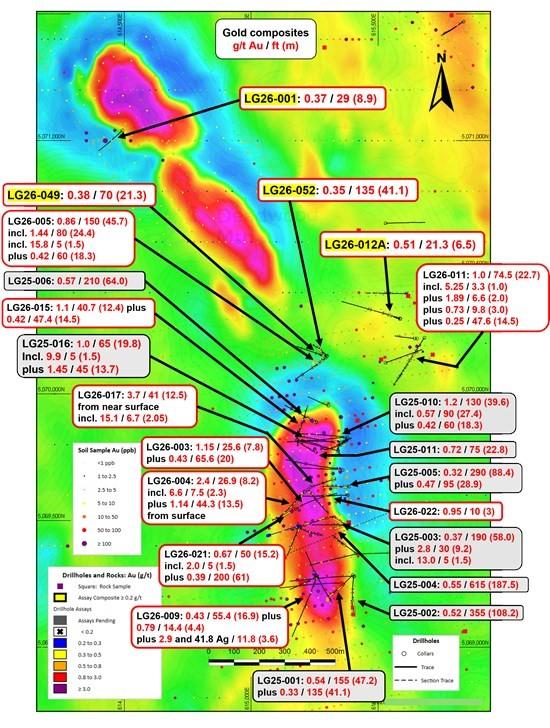
Figure 1: Plan View – 2025 and 2026 Baner Drill Results on Magnetics (new holes LG26-001,
LG26-012A, LG26-049 and LG26-052 highlighted; composites shown as g/t Au / ft (m))
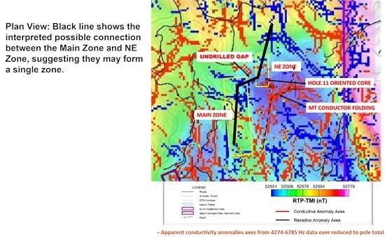
Figure 2: MT Conductive and Resistive Anomaly Axes over Magnetics (RTP-TMI), Main and NE Zones
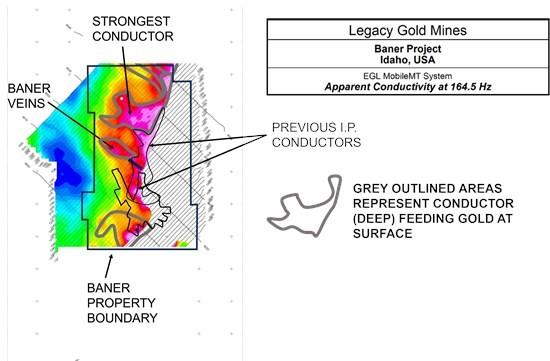
Figure 3: Plan View – MobileMT Apparent Conductivity (164.5 Hz), Baner Property
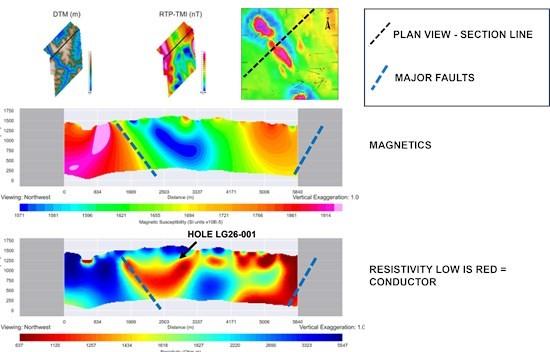
Figure 4: SW-NE Magnetic Susceptibility (top) and MT Resistivity (bottom) Sections through Hole LG26-001, looking northwest, with section line shown in plan
Exceptional Gold Intercepts Across Multiple Vein Systems at the B... READ MORE
Standard Uranium Ltd. (TSX-V: STND) (OTCQB: STTDF) (FSE: 9SU0) ... READ MORE
Revenue, Production and Net Income were all higher than Q2. ... READ MORE
PE-26-042 INTERSECTS 2.92 g/t over 7.30 m (70.00 m to 77.30 m) In... READ MORE