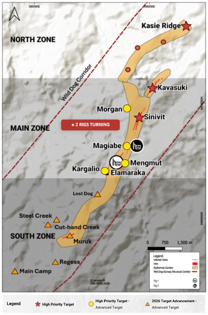
Great Pacific Gold Corp. (TSX-V: GPAC) (OTCQX: GPGCF) (FSE: 0B3) reports results from the maiden drill program at the Kasie Ridge target on its flagship Wild Dog Project in East New Britain Province, Papua New Guinea (Figure 1). Both holes, drilled approximately 315 m apart, confirm continuity within the Project’s largest preserved advanced argillic alteration system and define clear geological and geochemical vectors to guide follow-up work.
Highlights
“Kasie Ridge is now a much better-defined exploration target than it was before this program. With two completed holes, we have demonstrated continuity across a large, high-temperature magmatic-hydrothermal system, identified gold-bearing structures and established a coherent vector that strengthens toward the bottom of both holes.
“What is particularly important is where the first phase of drilling finished. KAS-01A ended in the strongest sulphide-rich alteration encountered, with increasing pyrite, high-temperature mineralogy and key pathfinder elements strengthening at depth. The interpreted magmatic source remains untested.
“The surface program and specialist studies will tell us whether and where Kasie Ridge justifies further holes. In the meantime, both of our rigs remain active at Magiabe and Mengmut, maintaining drilling momentum and a steady pipeline of assay results from the Main Zone epithermal targets at Wild Dog – our focus for the balance of 2026,” said Callum Spink, Chief Operating Officer and Vice President Exploration.
Figure 1: Wild Dog Project, showing Kasie Ridge at the northern end of the Wild Dog-Gunsap structural corridor.
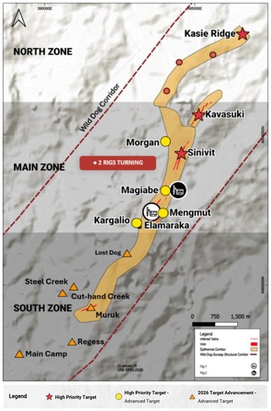
To view an enhanced version of this graphic, please visit:
https://images.newsfilecorp.com/files/11018/315149_gpfig109212026.jpg
Kasie Ridge Target
Kasie Ridge lies at the northern end of the Wild Dog structural corridor, approximately 5 km northeast of the historic Sinivit open pit within EL 2761 (Gunsap). Its advanced argillic alteration footprint extends approximately 1.5-2 km along strike and several hundred metres across. Historic XRD and fluid-inclusion work identified high-temperature alteration minerals and fluids, while reprocessed MobileMT data outlined a structurally complex zone beneath the ridge. Together, these datasets supported the first drill test of the target.
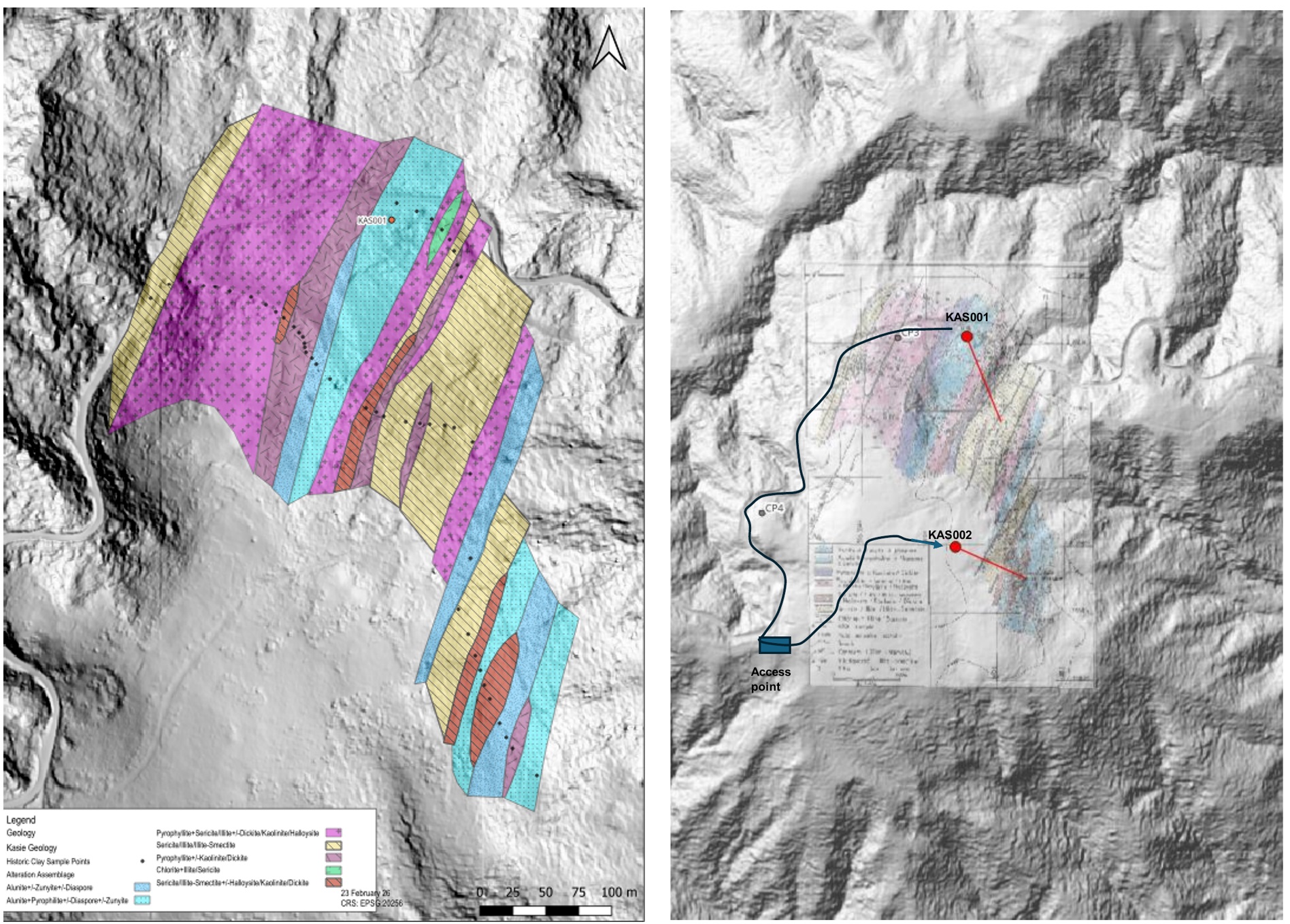
Figure 2: Kasie Ridge alteration assemblages and drill locations over LiDAR terrain. KAS-01A and KAS-02 tested positions approximately 315 m apart.
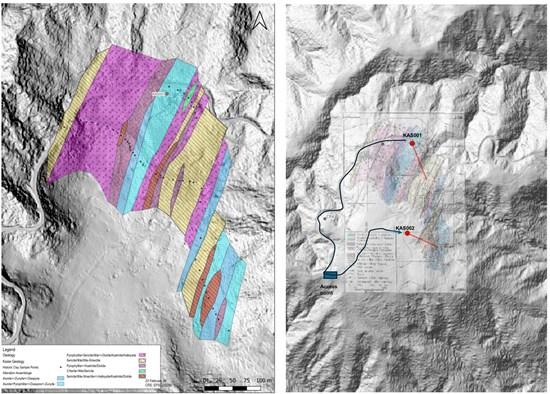
To view an enhanced version of this graphic, please visit:
https://images.newsfilecorp.com/files/11018/315149_gpfig209212026.jpg
Maiden Drill Program
KAS-01A (595.7 m) and KAS-02 (346.6 m) delivered 942.3 m of core, with KAS-02 collared approximately 315 m south of KAS-01A to test continuity closer to the interpreted deep conductive anomaly (Figure 2). Collar details are provided in Table 1.
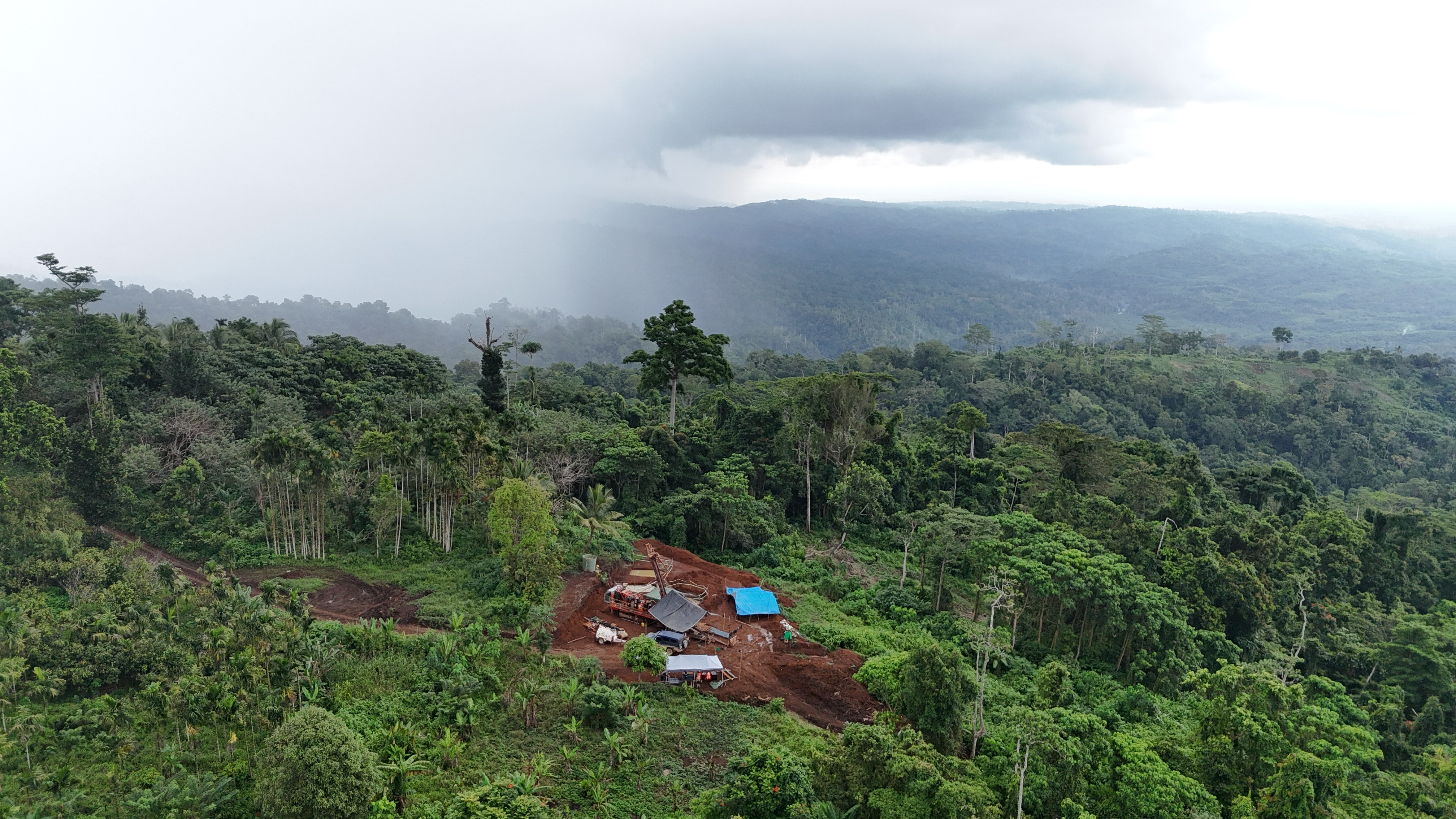
Figure 3: Aerial view of the KAS-02 drill pad at Kasie Ridge, within the Wild Dog Project, East New Britain Province, Papua New Guinea.
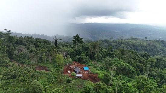
To view an enhanced version of this graphic, please visit:
https://images.newsfilecorp.com/files/11018/315149_67781f5c745deaeb_005full.jpg
| Hole ID | Easting | Northing | RL (m) | Dip (°) | Azimuth (°) | Depth (m) | Status |
| KAS-01 | 396599.6 | 9493496.5 | 592 | -69 | 160 | 174.2 | Abandoned; re-drilled as KAS-01A |
| KAS-01A | 396600.0 | 9493483.0 | 613 | -67 | 160 | 595.7 | Completed |
| KAS-02 | 396582.8 | 9493182.8 | 674 | -68 | 118 | 346.6 | Completed |
Table 1: Kasie Ridge drill collars (WGS84 / UTM Zone 56S).
Drilling Results
KAS-01A. The hole intersected a vertically zoned sequence from propylitic rocks through a pyrite-rich phyllic transition into massive chalcedonic silica and, below approximately 336 m, intensely silicified advanced argillic and phyllic alteration. Pyrite intensifies through the deepest approximately 130 m; hypogene anhydrite and visible chalcopyrite occur below approximately 480 m. The hole ended at 595.7 m in sulphide-bearing alteration, leaving the system open below.
KAS-02. The southern hole intersected correlated silica-rich, argillic and phyllic alteration, including sulphidic silicified tuffs and hydrothermal breccias. A massive chalcedonic silica unit at approximately 200-211 m correlates with the KAS-01A silica body, and advanced argillic alteration continues to approximately 316 m. These correlations demonstrate continuity across 315 m while also showing local structural variation.
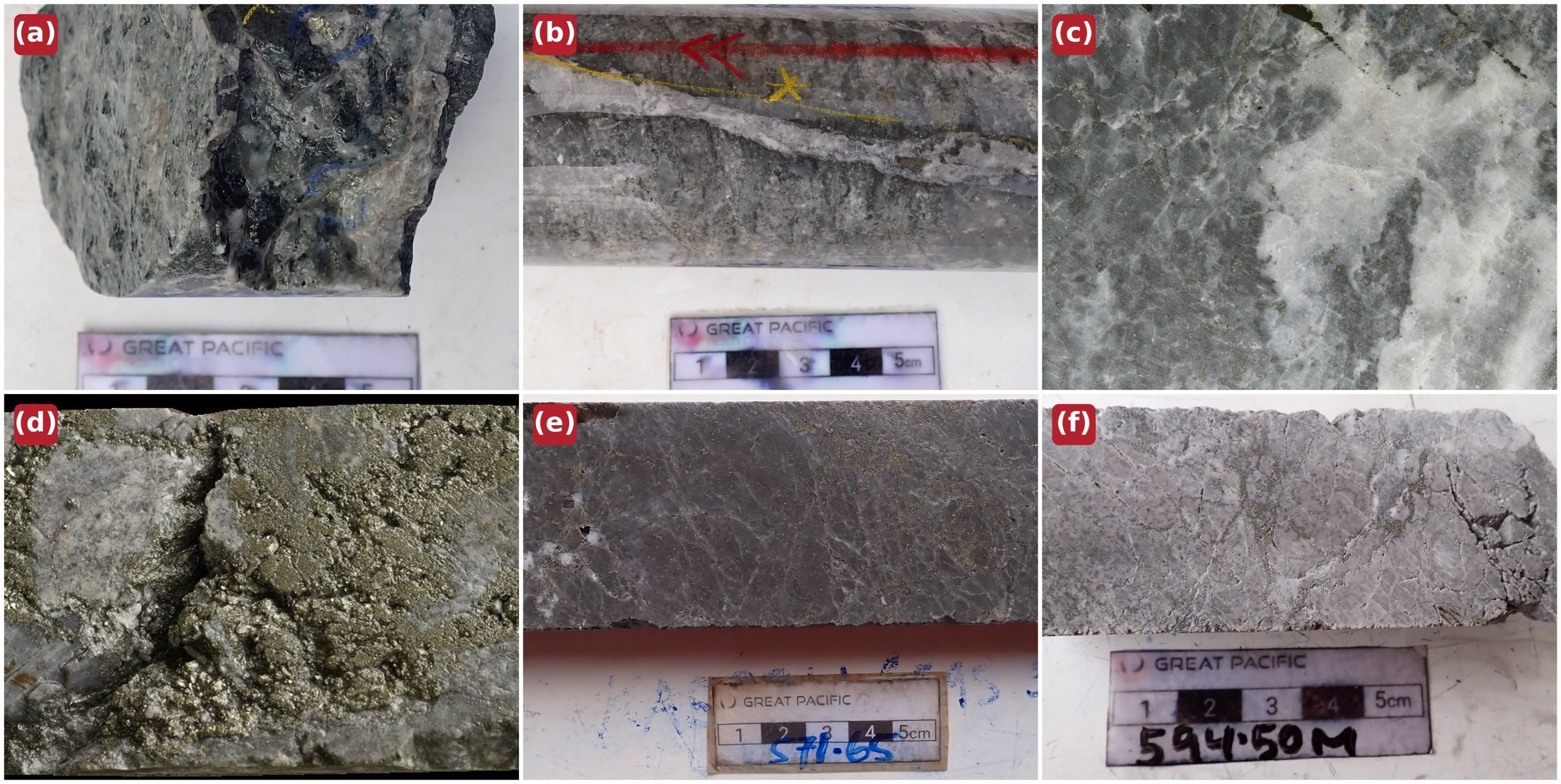
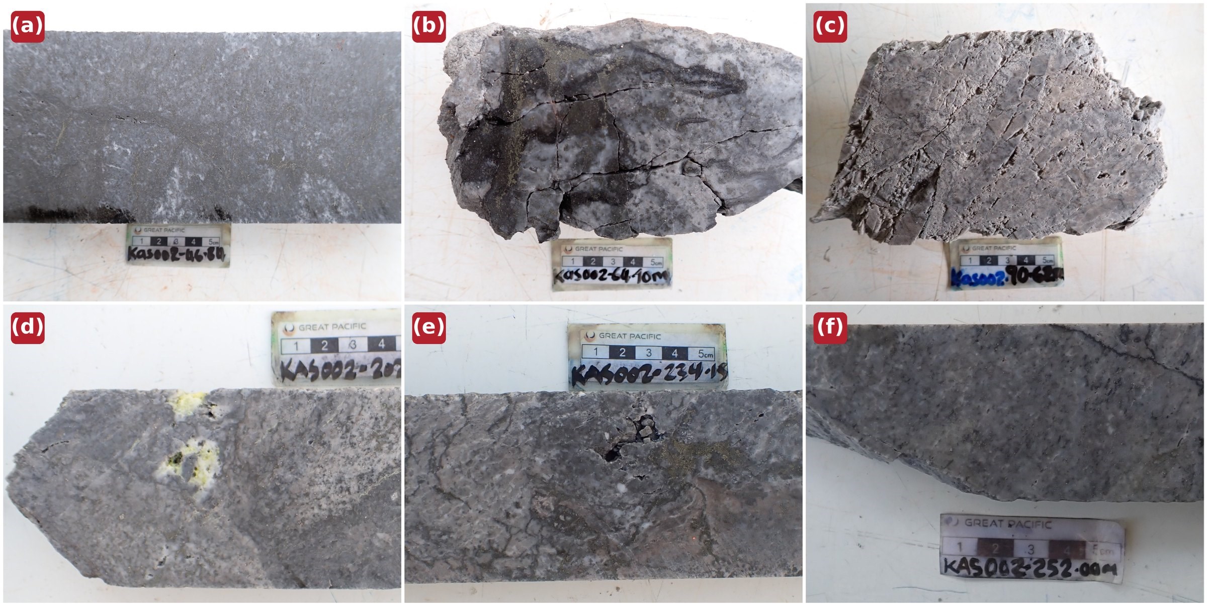
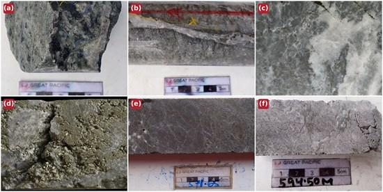
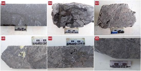
Representative core photographs are shown in Figure 4 (KAS-01A) and Figure 5 (KAS-02).
Figure 4 (a-f): KAS-01A core photographs. (a) 118.1 m – crackle breccia with chalcopyrite blebs in the propylitic zone; (b) 233.2 m – massive quartz-pyrite vein within the phyllic transition; (c) 275.8 m – banded grey-white chalcedonic silica at the top of the massive silica body (272-336 m); (d) 462.2 m – semi-massive pyrite with grey silica clasts within the deep sulphide zone; (e) 571.7 m – sulphide-laced silicified rock in the deepest zone; (f) 594.5 m – silicified, sulphide-bearing breccia 1.2 m above the end of the hole; the system remains open below.
To view an enhanced version of this graphic, please visit:
https://images.newsfilecorp.com/files/11018/315149_67781f5c745deaeb_006full.jpg
Figure 5 (a-f): KAS-02 core photographs. (a) 46.8 m – disseminated sulphide in silicified tuff; (b) 64.1 m – dark sulphide haloing quartz-carbonate veining; (c) 90.7 m – crackle-textured brecciation with fine sulphide replacement; (d) 202.7 m – patchy native sulphur (yellow) in the massive chalcedonic silica unit, direct evidence of condensing magmatic volatiles; (e) 234.2 m – silica-anhydrite-pyrite cut by dark sulphide stockwork veinlets within the 231-256 m gold-bearing zone; (f) 252.0 m – dark-sulphide stringers within the 231-256 m zone that returned individual samples up to 1.25 g/t Au.
To view an enhanced version of this graphic, please visit:
https://images.newsfilecorp.com/files/11018/315149_67781f5c745deaeb_007full.jpg
Assay Results
A total of 842 half-core samples from the two completed holes were analyzed for gold by 50 g fire assay, with silver and copper by aqua-regia digest and AAS. Full 48-element four-acid ICP-MS results have been received for 302 KAS-01A intervals from 118.0-479.4 m, supplemented by 82 spot pulps extending multi-element coverage to 595.6 m. KAS-02 multi-element results and 39 XRD results from 154-337 m remain pending.
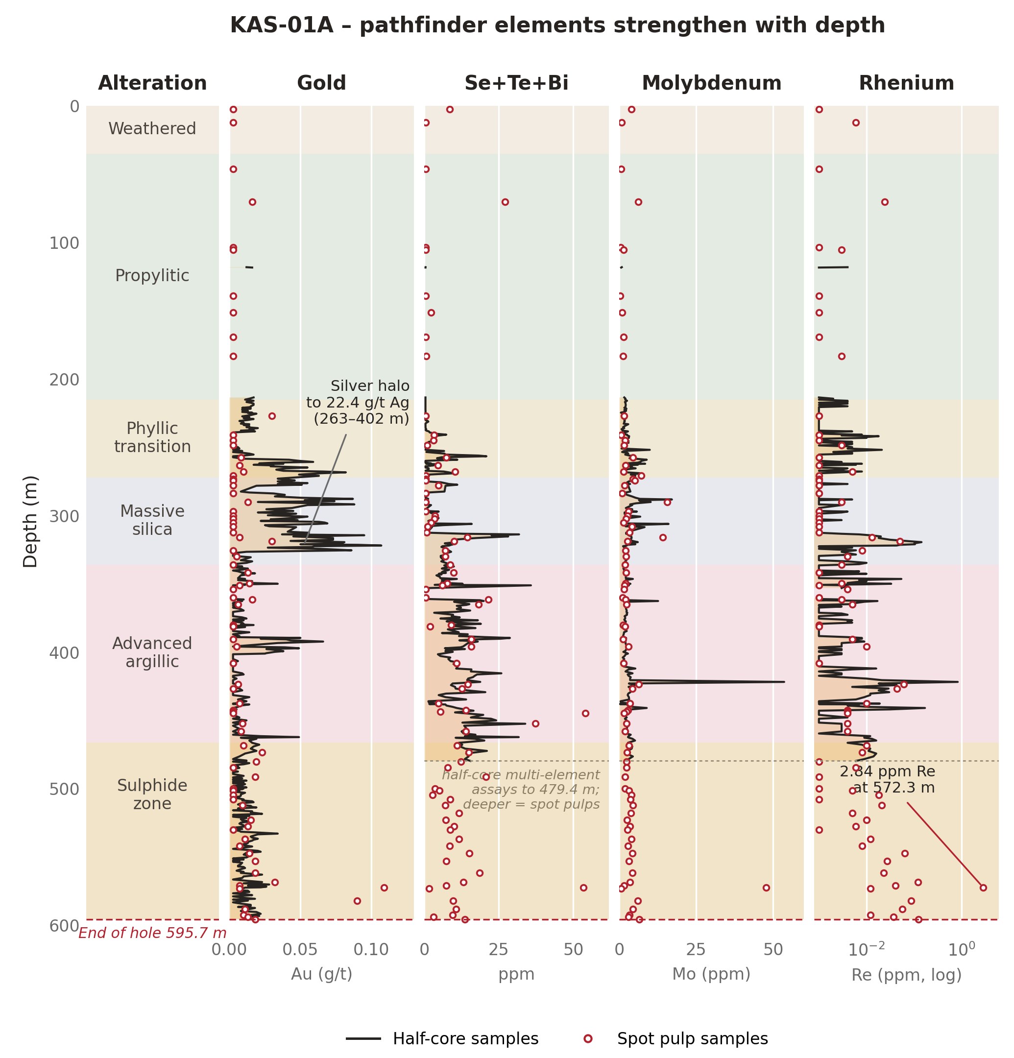
Gold is present in both holes and is most strongly developed in KAS-02, where two structurally controlled zones returned eight individual samples grading 0.20 g/t Au or better. The 141-166 m zone returned five samples between 0.20 and 1.55 g/t Au, including 1.55 g/t Au at 151.7 m and 0.38 g/t Au at 159.6 m; the 231-256 m zone returned 0.47 g/t Au at 231.6 m, 0.31 g/t Au at 251.6 m and 1.25 g/t Au at 254.2 m. KAS-01A returned a maximum of 0.11 g/t Au at 572.3 m and individual silver values up to 22.4 g/t Ag within a broad silver halo from approximately 263-402 m. Copper was uniformly low, with a maximum of 0.09%. The presence of gold in a magmatic-hydrothermal system of this scale is considered encouraging at this stage of exploration: it demonstrates that gold-bearing fluids moved through the system, and the structures that carried them are a direct target for follow-up work. All values reported are individual point samples presented to show metal distribution and support vectoring; individual values appear in Table 2, and peak KAS-01A pathfinder values appear in Table 3.
| Hole ID | Depth (m) | Au (g/t) | Ag (g/t) | Context |
| KAS-02 | 149.0 | 0.25 | 0.4 | Silicified tuff with sulphide veinlets (141-166 m interval) |
| KAS-02 | 151.7 | 1.55 | 0.7 | Silicified tuff with chalcopyrite-pyrite-dark sulphides (141-166 m interval) |
| KAS-02 | 159.6 | 0.38 | 0.9 | Silicified tuff with sulphide veinlets (141-166 m interval) |
| KAS-02 | 160.1 | 0.22 | 0.1 | Silicified tuff with sulphide veinlets (141-166 m interval) |
| KAS-02 | 165.6 | 0.20 | 1.2 | Silicified tuff with sulphide veinlets (141-166 m interval) |
| KAS-02 | 231.6 | 0.47 | <0.5 | Sulphide-rich hydrothermal breccia (231-256 m interval) |
| KAS-02 | 251.6 | 0.31 | 1.4 | Sulphide-rich hydrothermal breccia (231-256 m interval) |
| KAS-02 | 254.2 | 1.25 | 1.2 | Sulphide-rich hydrothermal breccia (231-256 m interval) |
| KAS-01A | 323.8 | 0.06 | 22.4 | Peak of silver halo, base of massive silica cap |
| KAS-01A | 390.4 | 0.04 | 21.4 | Silver halo, silicified advanced argillic zone |
| KAS-01A | 572.3 | 0.11 | <0.5 | With 2.84 ppm Re, 47.8 ppm Mo, 49.7 ppm Se |
Table 2: Individual enriched samples. These point assays are reported to characterize metal distribution and support exploration vectoring; they are not composited intercepts and are not necessarily representative of broader intervals (see Notes). Depths are downhole; true widths are not known.
| Pathfinder element | Peak value | Depth (m) | Association |
| Tellurium (Te) | 8.8 ppm | 448.9 | Magmatic volatile suite; telluride-style event |
| Selenium (Se) | 49.7 ppm | 572.3 | Magmatic volatile suite |
| Bismuth (Bi) | 13.5 ppm | 444.8 | Magmatic volatile suite |
| Molybdenum (Mo) | 53.6 ppm | 421.0 | Porphyry pathfinder suite |
| Rhenium (Re) | 2.84 ppm | 572.3 | Magmatic-degassing pathfinder |
Table 3: Peak pathfinder values, KAS-01A multi-element analyses. Values are geochemical anomalies reported as exploration vectors. KAS-02 multi-element results are pending.
Alteration Mineralogy
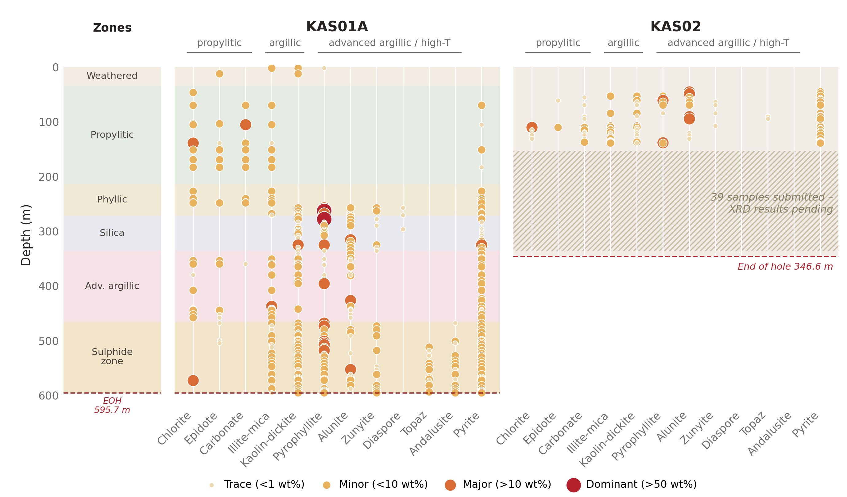
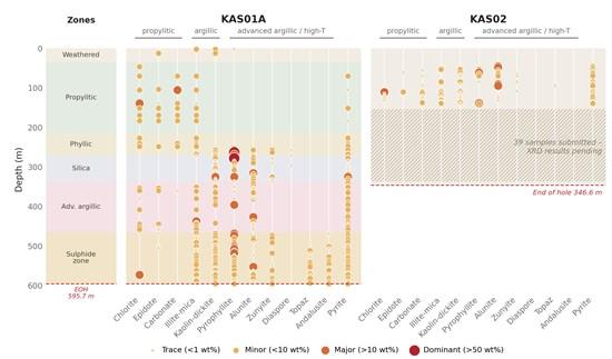
The Company has received 105 quantitative XRD results: 82 samples spanning 2.5-595.6 m in KAS-01A and 23 samples spanning 45.8-139.4 m in KAS-02. The mineralogy is systematically zoned and matches the logged alteration. In KAS-01A, propylitic assemblages give way downhole to quartz-mica-pyrite and then to alunite-pyrophyllite-zunyite-diaspore alteration; topaz and andalusite occur in the deepest approximately 190 m. Comparable acid alteration is present in KAS-02, 315 m to the south (Figure 6). The remaining KAS-02 XRD results are pending.
Figure 6: Downhole quantitative XRD mineralogy, KAS-01A and KAS-02. Dot size and colour show the laboratory abundance category; alteration zones are shown at left. Topaz and andalusite appear only in the deepest approximately 190 m of KAS-01A. KAS-02 samples from 154-337 m are pending.
To view an enhanced version of this graphic, please visit:
https://images.newsfilecorp.com/files/11018/315149_67781f5c745deaeb_008full.jpg
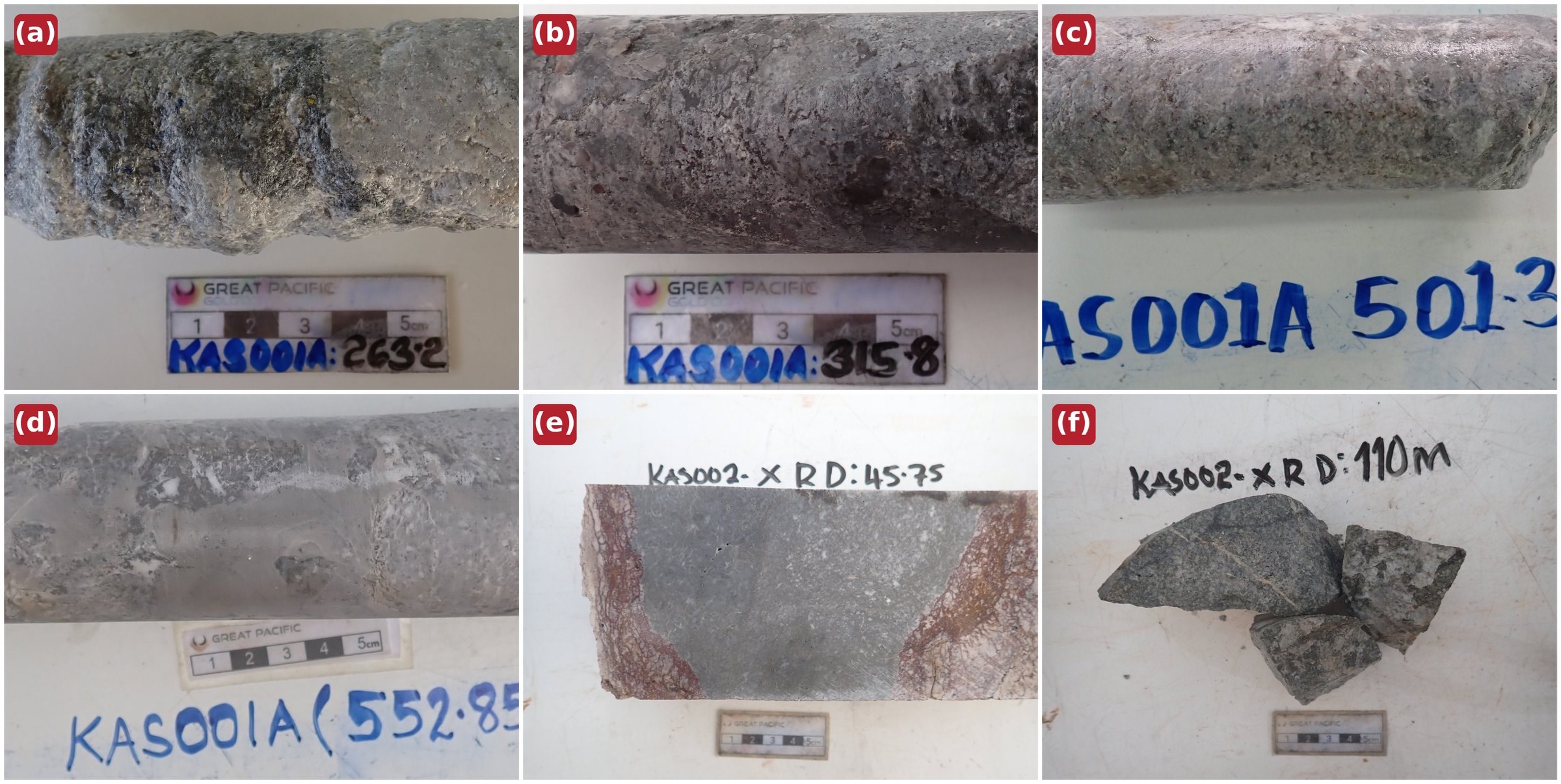
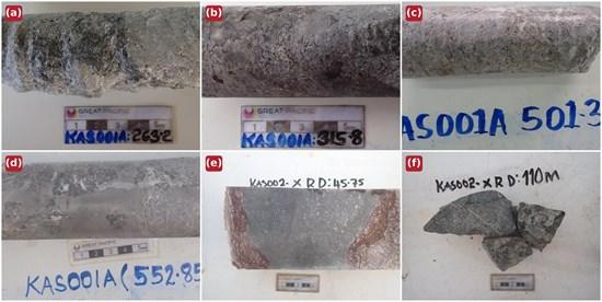
Zunyite, diaspore, topaz and andalusite are consistent with highly acidic, high-temperature magmatic fluids and support a hypogene origin for the alteration. Their distribution provides a practical vector for the current surface mapping program. The interpretation will be updated when the remaining KAS-02 XRD results are received. Representative XRD samples with their laboratory-measured mineralogy are shown in Figure 7.
Figure 7 (a-f): Representative XRD samples with laboratory-measured mineralogy. (a) KAS-01A 263.2 m – pyrophyllite (dominant) with zunyite and kaolin; (b) KAS-01A 315.8 m – alunite and quartz (major); (c) KAS-01A 501.4 m – quartz and pyrophyllite (major) with andalusite; (d) KAS-01A 552.9 m – alunite and quartz (major) with topaz, pyrophyllite, zunyite and andalusite: the full high-temperature acid suite 43 m above the end of the hole; (e) KAS-02 45.8 m – alunite and quartz (major); (f) KAS-02 110.0 m – quartz (dominant) with chlorite, carbonate and kaolin. Mineral abundances are laboratory-reported semi-quantitative categories.
To view an enhanced version of this graphic, please visit:
https://images.newsfilecorp.com/files/11018/315149_67781f5c745deaeb_009full.jpg
Downhole Geochemical Vector
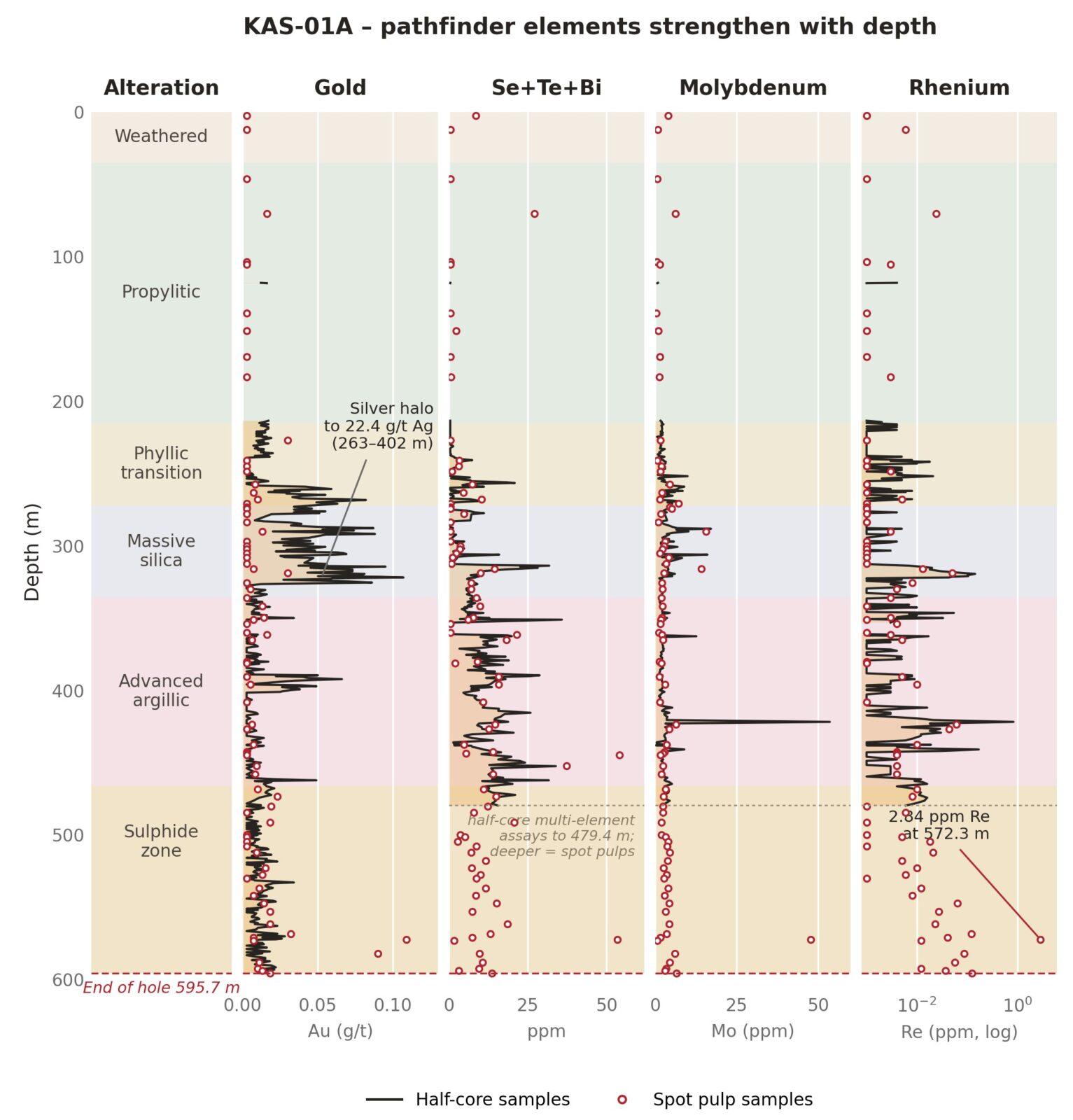
KAS-01A multi-element results define a coherent downhole increase in selenium-tellurium-bismuth, molybdenum and rhenium (Figure 8). Combined Se+Te+Bi values rise from less than 1 ppm in the upper propylitic rocks to sustained values of 5-20 ppm below 300 m, peaking at 54 ppm near 445 m. Molybdenum peaks at 53.6 ppm at 421.0 m. Rhenium rises from approximately 0.002 ppm in the upper hole to repeated values of 0.02-0.12 ppm below 500 m and remains elevated in the deepest sample, with a peak of 2.84 ppm at 572.3 m coincident with 47.8 ppm Mo, 49.7 ppm Se and 0.11 g/t Au. Arsenic and antimony remain low. KAS-02 multi-element results are pending.
Figure 8: KAS-01A downhole geochemistry. The key pathfinder elements strengthen with depth and are still climbing at the end of the hole (rhenium shown on a logarithmic scale). Half-core multi-element assays cover 118.0-479.4 m; deeper multi-element values are spot pulp samples.
To view an enhanced version of this graphic, please visit:
https://images.newsfilecorp.com/files/11018/315149_67781f5c745deaeb_010full.jpg
Interpretation
The Company’s current model is that drilling tested a preserved lithocap above or beside an untested magmatic source. High-temperature minerals, increasing pyrite and anhydrite, visible chalcopyrite below approximately 480 m and strengthening downhole pathfinders are consistent with a source below or lateral to the drilling. The structurally controlled gold enrichment in KAS-02 may reflect a later mineralizing event. Any follow-up drilling would target both the source of the lithocap and structures associated with the later gold event. The model may be refined as pending results are received.
Surface Program
Further surface exploration work is underway at Kasie Ridge, including:
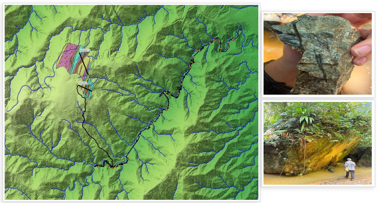
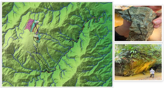
Figure 9: Follow-up surface work at Kasie Ridge. The first 6.47 km Minju Creek traverse mapped and sampled drainages south and east of the drilled target, following up porphyry-style quartz-chlorite-chalcopyrite-magnetite float and silicified boulders as part of the program to refine vectors and identify additional drill targets.
To view an enhanced version of this graphic, please visit:
https://images.newsfilecorp.com/files/11018/315149_67781f5c745deaeb_011full.jpg
Drilling Update – Magiabe and Mengmut
Both of the Company’s diamond drill rigs are active on the Main Zone drilling program at the Magiabe and Mengmut targets. To 15 September 2026, 1,639.4 metres had been drilled across nine holes: three holes (590.2 m) at Magiabe, testing the main Magiabe Vein and the Magiabe West Vein approximately 700 m southwest of Sinivit (see news release dated August 5, 2026), and six holes (1,049.2 m) at Mengmut, the first westerly directed drilling at that target, testing approximately 850 metres of strike. Seven holes are complete and two are in progress.
Logging to date has intersected structurally controlled corridors with phyllic and silicic alteration, quartz-sulphide veining and locally abundant pyrite with trace chalcopyrite at both targets. Core from the completed holes has been logged and sampled, with the next batch of samples scheduled for dispatch to the laboratory on 18 September 2026. Assays for all holes are pending and will be reported once received and validated.
Notes
On behalf of Great Pacific Gold:
Alex Heath
Chief Executive Officer and Director
For further information, visit gpacgold.com or contact:
Investor Relations
Phone +1-778-262-2331
Email: info@gpacgold.com
Qualified Person
The technical content of this news release has been reviewed, verified and approved by Callum Spink, Chief Operating Officer and Vice President Exploration of Great Pacific Gold Corp., who is a Member of the Australian Institute of Geoscientists (MAIG) and a Qualified Person as defined by National Instrument 43-101 Standards of Disclosure for Mineral Projects. Mr. Spink has verified the data disclosed in this release by reviewing original drill logs, sampling records, laboratory assay certificates, XRD mineralogy reports, QA/QC results and the Company’s drillhole database, and by cross-checking reported intervals against original laboratory data. Historical exploration results have been compiled from and reviewed against available historical reports and records but have not been independently verified through resampling or other confirmatory work. Mr. Spink is not independent of the Company.
Quality Assurance and Quality Control
Drill core was logged, cut and sampled at the Company’s secure core facility and transported under chain-of-custody procedures to the independent Intertek laboratory in Lae, Papua New Guinea, for preparation. Samples were dried, crushed to at least 80% passing 2 mm, riffle split to approximately 3 kg and pulverized to at least 80% passing 75 microns. Gold was analyzed by 50 g lead-collection fire assay with an AAS finish; silver and copper by aqua-regia digest with an AAS finish; and multi-element geochemistry by four-acid digest with an ICP-MS finish at Intertek’s ISO/IEC 17025-accredited Australian laboratories. Intertek also completed the quantitative XRD analyses. Certified reference materials and field blanks were each inserted at a rate of 1 in 20. QA/QC results associated with the assays reported in this release were reviewed and considered acceptable for the purposes of this disclosure.
About Great Pacific Gold
Great Pacific Gold is focused on advancing its flagship Wild Dog Project in Papua New Guinea.
Wild Dog covers the 15 km Wild Dog structural corridor in East New Britain Province. The Project hosts a large epithermal system with numerous high-grade gold-copper drill results and five district-scale porphyry targets, including Magiabe and Kasie Ridge. Two diamond drill rigs are advancing targets, supported by a field exploration team.
The Company also holds the Kesar and Arau projects in the Eastern Highlands Province, contiguous with K92 Mining Inc.’s mine tenements, and the Tinga Valley Project in western PNG.
Apollo Silver Corp. (TSX-V: APGO) (OTCQB: APGOF) (Frankfurt: 6ZF) reports that Ejido Benito Juárez,... READ MORE
Blue Jay Gold Corp. (TSX-V: JAY) (OTCQB: JAYGF) (FSE: JAY), today reported results from the metallur... READ MORE
Canagold Resources Ltd. (TSX: CCM) (OTCQB: CRCUF) (FSE: CANA) is pleased to announce it has arranged... READ MORE
DPM Metals Inc. (TSX: DPM) (ASX: DPM) is pleased to report results from delineation drilling at the ... READ MORE
Alpha Exploration Ltd. (TSX-V: ALEX) is pleased to announce a first batch of results from its ongo... READ MORE