








Highlights
Selkirk Copper Mines Inc. (TSX-V: SCMI) (FSE: IO20) (OTCQB: SKRKF) is pleased to announce initial results from the Phase 2 drill program which commenced in May 2026, at the Minto Project in Yukon, Canada.
Our exploration and discovery team, applying fundamental geoscience know-how and experience, closely coordinated with resource modeling and mine planning teams, continues to meaningfully expand zones of mineralization at Minto North, Minto East, Copper Keel, Ridgetop, 118, and the newly discovered 117 and 301 lenses, all of which is being translated into integrated mine plans. A key objective of the Phase 1 and Phase 2 Drill Programs is to make meaningful additions to mine life in a cost-effective manner, thus far we are meeting this objective.
The updated Mineral Resource Estimate and Preliminary Economic Assessment are on target for completion in the second half of July which, respectively, will demonstrate the prospectivity of the geological system as well as the fundamentals of the investment opportunity we see in the Minto Project.”
2026 Phase 2 Drill Program
Four drill rigs are active on the Phase 2 drill program, which commenced on May 1, 2026. This drill program is targeting 50,000 metres with a focus on expansion, exploration, and infill drilling to support resource expansion of key target areas as well as increased resource confidence.
Drill productivity has been consistently high throughout the first two months of the Phase 2 program. Drilling rates have achieved up to 220 metres per day for a single drill, and daily productivity is averaging approximately 120 metres per day. The high productivity is attributed to an experienced team that is benefiting from site-specific knowledge that has been developed over the past nine months. A robust core logging process is maintained to ensure new drill core is reviewed and interpreted on a daily basis. The team continues to focus on quality, consistency, efficiency, and safety for all aspects of the drill program as well as other activities on site.
As of June 30, 27,300 metres of drilling has been completed in 104 holes, comprising 54% of the planned 50,000 metres. Reported here are results from the first nine holes drilled in May. Turnaround time for assay results is currently six to eight weeks. The drill program is anticipated to continue until approximately late August with assay results expected to be released throughout the summer and fall of 2026.
2026 Technical Field Data Collection
In addition to the resource drilling program described above, the company has initiated a technical data collection program that will inform an upcoming Feasibility Study that is planned for completion in mid-2027. The team is making maximum use of the summer months to collect field data across the project area.
Technical data collection scopes this summer include the following:
Table 1: Summary of Phase 2 Drilling Completed by Location
| Zone | Holes Completed | Meters Drilled | Holes with Assays Reported |
| Minto North | 27 | 6,546 | 3 |
| Minto East | 3 | 1,185 | 3 |
| Minto Main | 20 | 7,257 | 1 |
| Area 118 | 20 | 6,141 | 1 |
| Copper Keel | 31 | 6,925 | 0 |
| Ridgetop | 0 | 0 | 0 |
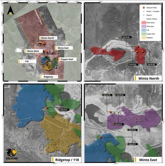
Figure 1: Plan view of the Minto Mine Property showing surface projections of mineralized zones as well as Phase 1 and Phase 2 drill collars. Drill hole results presented here are highlighted.
Minto North Drill Results
At Minto North, the Phase 2 drill program is testing for expansion of mineralized lenses as well as infill drilling of planned priority mining areas. Reported here are three holes drilled at the 120 Lens, which has not been previously investigated by Selkirk Copper.
Results from three drill holes targeting the 120 Lens indicate that mineralization in this location is characterized by folioform and disseminated chalcopyrite, bornite, and associated with magnetite. Host rocks for mineralization are pervasively foliated granodiorite and migmatite, similar to other mineralized areas within Minto North.
Additionally, the Phase 2 drill holes reported here targeting the 120 Lens represent the first-ever oriented core structural information collected in this location. Historical workers had interpreted significant structural complexity at Minto North, but very little structural data was available. Results of the drilling reported here will provide important information on joint orientation, foliation fabric, and mineralized trends that will be used to inform subsequent geotechnical designs and detailed resource modelling.
Hole 26SCM183 targeted a 30-metre step-out west of previous drilling in the northwestern part of the 120 Lens. This hole intersected high grade mineralization comprising 2.22% Cu, 0.41 g/t Au, and 5.3 g/t Ag (2.59% CuEq) over 4.5 m, within a broader interval of 1.16% Cu, 0.31 g/t Au, and 3.2 g/t Ag (1.44% CuEq) over 11.9 m. The results of this hole indicate that high-grade mineralization remains open for further expansion westwards in this location. Further drilling is planned to follow-up on this hole.
Hole 26SCM186 targeted the northern portion of the 120 Lens, at the limits of previous drilling. This hole intersected a broad interval of moderate grade mineralization comprising 0.41% Cu, 0.09 g/t Au, and 1.8 g/t Ag (0.51% CuEq). The results of this hole indicate that a broad width of mineralization remains open to the north, however the lower grade observed in this hole may not warrant immediate follow-up.
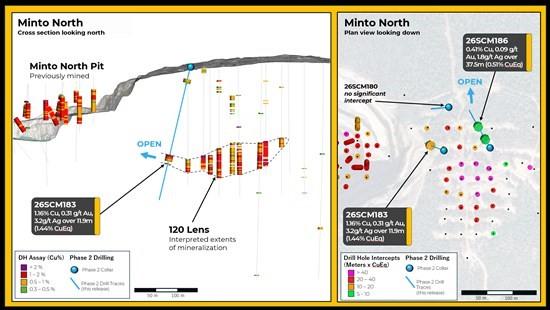
Figure 2: Cross section view of Minto North highlighting Phase 2 drill results from the 120 Lens
117 Lens Drill Results
In the Minto Main area, follow-up drilling on the 117 Lens is a priority objective of the Phase 2 drill program. This target, discovered during the Phase 1 Drill program, is located close to existing underground mining infrastructure and has the potential to be a low-cost addition to the restart mine plan. This newly discovered lens is a very good example of the outcomes of applying fundamental geosciences to exploration in a mature system.
The Phase 2 drilling at the 117 Lens will focus on exploration drilling to understand the extents of this zone; as well as infill drilling to confirm the grade and continuity within this zone. Reported here are results from the two holes drilled in this location as part of the Phase 2 program.
Hole 26SCM175 and 26SCM177 were drilled to infill between widely spaced previous drillholes. Both drill holes intersected significant mineralization, most notably 26SCM175 which intersected a broad interval comprising 1.02% Cu, 0.35 g/t Au, 4.2 g/t Ag (1.35% CuEq) over 22.7 m. Mineralization in this hole is characterized by folioform chalcopyrite and bornite hosted in pervasively foliated granodiorite. Results of this hole confirm the grade continuity and thickness of mineralization in this portion of the 117 Lens. Mineralization remains open to the north in this location, indicating a priority target for follow-up.
Area 118 Drill Results
In Area 118, follow-up drilling on the 301 Lens is a priority objective of the Phase 2 drill program. This target is located at relatively shallow depths immediately adjacent to the underground mine portal which presents the opportunity for low-cost development within a restart mine plan. This newly discovered lens is another good example of the prospectivity of the system that is being delivered by our exploration and discovery focused geosciences team.
The Phase 2 drilling in this area will focus on exploration drilling to investigate potential extensions to mineralization in several areas; as well as infill drilling to confirm the grade and continuity within the 301 Lens. Reported here are results from the first hole drilled in this location as part of the Phase 2 program.
Hole 26SCM181 targeted a gap in drilling located nearby to historical underground workings. This hole successfully intersected two mineralized intervals including: 0.69% CuEq over 29.1 m and 0.54% CuEq over 14.3 m (see Table 2 for detailed assays). The results of this hole confirm that relatively broad intervals of mineralization occur very close to existing underground development, however in this location the results are marginally economic. This area is being evaluated for potential follow-up drilling, however subsequent drilling has focused on the 301 Lens, as shown in Figure 3 below.
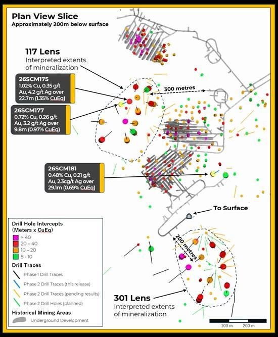
Figure 3: Plan view at the elevation of the 117 Lens and 301 Lens, approximately 200 metres below surface. This image highlights significant intercepts, historical mining areas, Phase 1 drill results, Phase 2 drill results, and holes that are pending results and planned for drilling.
Minto East Drill Results
At Minto East, the Phase 2 drill program is targeting expansion of mineralized lenses at Minto East, with a focus on investigating an under-explored area between Minto East and Minto Main. Reported here are the results from three holes drilled at the same collar location on different azimuths.
The three holes reported here all intersected narrow intervals of high-grade mineralization around 70 to 140 metres depth. Significant intervals include: Hole 26SCM174 which intersected 3.38% CuEq over 2.2 metres; Hole 26SCM176 which intersected 3.53% CuEq over 1.9 metres; and Hole 26SCM178 which intersected 4.28% CuEq over 5.9 metres. Results of these holes are interpreted to indicate that narrow zones of high-grade mineralization extend beyond the limits of previous mining in the Minto Main area. This area is being evaluated for potential follow-up drilling.
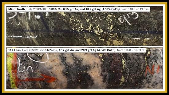
Figure 4: Drill core photographs of high-grade mineralization at Minto North and the 117 Lens.
Table 2: Collar Locations and Header Information
| Hole ID | Easting | Northing | Azi | Dip | EOH (m) | Zones | Category |
| 26SCM174 | 384905 | 6945157 | 0 | -70 | 447 | Minto East | Expansion |
| 26SCM175 | 384726 | 6944712 | 341.5 | -85 | 357 | Minto Main | Infill |
| 26SCM176 | 384903 | 6945157 | 186 | -80 | 357 | Minto East | Expansion |
| 26SCM177 | 384726 | 6944712 | 298.5 | -78 | 354 | Minto Main | Infill |
| 26SCM178 | 384904 | 6945157 | 0 | -90 | 381 | Minto East | Expansion |
| 26SCM180 | 384563 | 6946052 | 265 | -74 | 126 | Minto North | Expansion |
| 26SCM181 | 384856 | 6944156 | 282 | -80 | 435 | Area 118 | Expansion |
| 26SCM183 | 384556 | 6945969 | 291 | -77 | 177 | Minto North | Expansion |
| 26SCM186 | 384642 | 6945977 | 329 | -68.5 | 222 | Minto North | Infill |
Table 3: Significant Interval Table
| Hole ID | From | To | Length (m) |
Cu % | Au g/t | Ag g/t | CuEq % | Zone | Category |
| 26SCM174 | 72.8 | 75.0 | 2.2 | 1.62 | 1.85 | 12.6 | 3.38 | Minto East | Expansion |
| 26SCM175 | 316.9 | 339.5 | 22.7 | 1.02 | 0.35 | 4.2 | 1.35 | Minto Main | Infill |
| 26SCM176 | 139.1 | 141.0 | 1.9 | 1.66 | 2.03 | 9.6 | 3.53 | Minto East | Expansion |
| and | 305.7 | 311.5 | 5.9 | 1.13 | 0.30 | 3.7 | 1.41 | Minto East | Expansion |
| 26SCM177 | 327.8 | 337.6 | 9.8 | 0.72 | 0.26 | 3.2 | 0.97 | Minto Main | Infill |
| 26SCM178 | 90.0 | 101.2 | 11.2 | 0.70 | 0.20 | 2.1 | 0.89 | Minto East | Expansion |
| incl. | 90.0 | 93.0 | 3.0 | 1.91 | 0.57 | 5.7 | 2.44 | Minto East | Expansion |
| and | 142.0 | 147.9 | 5.9 | 2.33 | 1.98 | 22.3 | 4.28 | Minto East | Expansion |
| 26SCM180 | No Significant Intercept | Minto North | Expansion | ||||||
| 26SCM181 | 142.3 | 156.6 | 14.3 | 0.49 | 0.05 | 1.3 | 0.54 | Area 118 | Expansion |
| and | 282.9 | 311.9 | 29.1 | 0.48 | 0.21 | 2.3 | 0.69 | Area 118 | Expansion |
| 26SCM183 | 116.6 | 128.5 | 11.9 | 1.16 | 0.31 | 3.2 | 1.44 | Minto North | Expansion |
| incl. | 116.6 | 121.1 | 4.5 | 2.22 | 0.41 | 5.3 | 2.59 | Minto North | Expansion |
| 26SCM186 | 120.5 | 158.0 | 37.5 | 0.41 | 0.09 | 1.8 | 0.51 | Minto North | Infill |
| CuEq Calculation: CuEq = ((Cu% × CuP × RCu × 2204.62)+(Au g/t ÷ 31.1035 × AuP × RAu) + (Ag g/t ÷ 31.1035 × AgP × RAg ))/(CuP × RCu × 2204.62) Where: CuP/AuP/AgP = US$ commodity prices of $4.25/lb Cu, $2500/oz Au, $29/oz Ag; RCu = Cu Recovery = 98%; RAu = Au Recovery = 85%; RAg= Ag Recovery = 85% Recoveries as estimated from historical mineral processing results. |
|||||||||
QAQC Procedures and Data Validation
The Company is drilling NQ sized core. Following data collection, core is cut along the long axis, with half of the core going to the lab for chemical analysis and the remaining half kept in sequence as record. The half core samples are packaged with the corresponding sample tag id and sealed. All sampling is conducted by Selkirk Copper Mines Inc. and subject to Company standard internal quality control and quality assurance (QAQC) programs. QAQC procedures include the insertion of certified reference material, coarse blank materials, and field duplicate analysis, as well as standard laboratory procedures to monitor contamination during preparation, analytical accuracy, and precision. QAQC insertion rates by Selkirk Copper approximate 15% of all samples at set intervals.
For the Phase 2 drill program, all samples were sent to ALS’s prep facility in Whitehorse, then shipped to ALS’s analytical laboratory in Vancouver. All samples are prepared by crushing rock to 70% passing 2mm screen, then splitting a 250g sub-sample using a riffle splitter before being pulverized 85% passing 75 microns. Gold is analyzed by 30 g Fire Assay (Au-AA23) with atomic absorption (AAS) analysis followed by gravimetric finish for overlimit results. Copper is analyzed by four-acid digest (ME-ICP61) with inductivity coupled plasma – atomic emission spectroscopy (ICP-AES) finish. If copper overlimit results are triggered a second four-acid digest for high grade copper (Cu-OG62) is conducted. Samples containing greater than 1000 ppm copper are also analyzed for soluble copper using a sulphuric acid leach (Cu-AA05) analysis with AAS finish is performed. ALS Vancouver holds an ISO/IEC 17025 standard accreditation.
QAQC results are reviewed by Selkirk Copper upon receipt of assay results. Overall, QAQC results show strong analytical performance across Cu, Au, and Ag datasets. All control standards are within acceptable tolerance, with no significant outliers or systematic bias observed.
Primary intervals are reported as drill core length, with true widths estimated to be approximately 90% of core lengths, based on the sub-horizontal to shallow-dipping nature of the modelled mineralized zones.
Mineral Resource Estimate Details
The following table summarizes the current Minto Mineral Resource Estimate:
Table 4: Global Mineral Resource Estimate for the Minto Project (Effective Date: April 7, 2025)
| Type | Cut | Class | ROM | In Situ Grade | Metal | |||||||
| (CDN$) | Tonnage (000) |
NSR (CDN$) |
Cu (%) |
Au (gpt) |
Ag (gpt) |
Ox Ratio |
ASCu (%) |
Cu (Mlbs) |
Au (Koz) |
Ag (Koz) |
||
| OP | $30 | Indicated | 6,085 | $89.11 | 0.897 | 0.274 | 2.9 | 0.15 | 0.163 | 120.3 | 53.7 | 560.4 |
| Inferred | 9,496 | $73.71 | 0.702 | 0.162 | 2.4 | 0.07 | 0.057 | 146.9 | 49.3 | 738.4 | ||
| UG | $80 | Indicated | 6,504 | $183.90 | 1.489 | 0.636 | 5.6 | 0.06 | 0.090 | 213.5 | 132.9 | 1,167.6 |
| Inferred | 14,162 | $156.85 | 1.281 | 0.539 | 4.9 | 0.06 | 0.075 | 399.9 | 245.4 | 2,229.6 | ||
| Total | Varies as Above |
Indicated | 12,588 | $138.08 | 1.203 | 0.461 | 4.3 | 0.10 | 0.125 | 333.8 | 186.6 | 1,728.0 |
| Inferred | 23,658 | $123.48 | 1.048 | 0.387 | 3.9 | 0.07 | 0.068 | 546.8 | 294.7 | 2,968.1 | ||
| Notes |
|
|||||||||||
References
1 See 2025-08-06 Technical Report “NI 43-101 2025 Mineral Resource Estimate Update for the Minto Property, Yukon, Canada” effective date 2025-04-07 filed by Venerable Ventures Ltd., available on SEDAR+ (sedarplus.ca).
Technical aspects of this news release have been reviewed, verified and approved by Leif Bailey, P.Geo., Director of Geoscience & Exploration of Selkirk Copper Mines Inc., who is a qualified person as defined by National Instrument 43-101 – Standards of Disclosure for Mineral Projects.
About Selkirk First Nation
Selkirk First Nation is centered in Pelly Crossing, a community in central Yukon, 280 km north of Whitehorse. They are a self-governing First Nation, having signed its Final and Self-Government Agreements in 1997. Selkirk First Nation owns 4,740 square kilometers of Settlement Land, including 2,408 square kilometers where they own both the surface and subsurface. Selkirk First Nation is one of three self-governing Northern Tutchone First Nations in the Yukon. The Selkirk First Nation, indirectly, holds a controlling equity stake in Selkirk Copper.
About Selkirk Copper
Selkirk Copper is a well-financed, newly formed company with a controlling interest held by the Selkirk First Nation through its wholly owned subsidiary, that, in partnership with the Selkirk First Nation, is completing a thorough exploration drilling campaign and a restart and redevelopment plan for the former Minto copper-gold-silver mine based on best-in-class environmentally sustainable mining, development and reclamation practice. Selkirk Copper controls 26,850 hectares of prospective mineral claims located in the Minto-Carmacks copper belt as well as significant open-pit and underground infrastructure, a 4,100 tonne per day processing plant, 400-person full-rotation camp, water treatment facilities, numerous ancillary buildings, and mobile equipment centered on the former Minto copper-gold-silver mine. Selkirk Copper’s mineral tenure, operation infrastructure, access roads and powerline, is located on or adjacent to Lands of the Selkirk First Nation much of which is surrounded by prospective Selkirk First Nation Category A Lands.
Brutus Mining Inc. (CSE: BRU) (FSE: ZI3) is pleased to announce that it has closed its non-brokered ... READ MORE
Jaguar Uranium Corp. (NYSE American: JAGU) is pleased to announce an independent Mineral Resource E... READ MORE
Auro Metals Inc. (TSX-V: AURO) (OTCQB: AURFF), is pleased to announce the assay results of the fina... READ MORE
Endeavour Silver Corp. (NYSE: EXK) (TSX: EDR) is pleased to announce that repairs to the primary bal... READ MORE
Scorpio Gold Corp. (NASDAQ: SGLD) (TSX-V: SGLD) (OTCQB: SRCRF) (FSE: RY9) is pleased to announce re... READ MORE


